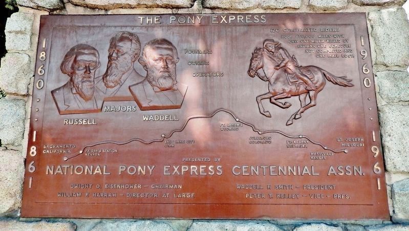
On North Carson Street (Lincoln Highway) (Business U.S. 395) north of West Robinson Street, on the left when traveling north.
”Pony” Bob Haslam, considered to be the greatest of all Pony Express riders, rode for the Express from the beginning to the end. His route was through Carson City, one of the relay stations.
Erected by the Nevada Pony Express Centennial . . . — — Map (db m128553) HM
Abraham Curry, the “Father of Carson City”, accomplished more in his 15 year residence than most men hope to in a lifetime. Not only did he purchase the land in 1858 which is now Carson City, but laid out the townsite and built many of its . . . — — Map (db m20874) HM
On Spooner Drive near Windridge Drive, on the right when traveling west.
In 1902 Marion Jefferson Blackwell purchased 360 acres from the State of Nevada, 556 acres of adjoining land from Sweeney’s Hot Springs and a lot with a house. He raised carp and catfish to sell commercially also hay and horses. Neighbors used the . . . — — Map (db m116178) HM
On Elizabeth Street at West Robinson Street, on the left when traveling north on Elizabeth Street.
Built by Duane L. Bliss
Lumber & railroad Magnate
1879
In it's time the most modern & largest home in Nevada.
Entirely constructed of clear lumber & square nails.
First home in Nevada entirely piped for gas lighting. — — Map (db m284410) HM
On South Carson Street (Business U.S. 395), on the right when traveling south.
[Front of Marker:]
Dedicated April 12, 1996
Carson City
Original Station
Apr. 3, 1860 - Nov. 20, 1861
by
Byron L. & Peggy Clark & Family
Bob & Tina McFadden
Mae & Jim Thorpe
The Bike Smith
Betty Young & Erica . . . — — Map (db m23038) HM
Near South Carson Street (U.S. 395/50) near East Musser Street.
Nevada's State Capital, one of the state’s oldest communities, was established in 1851 as Eagle Station, a trading post and ranch on the Carson Branch of the California Immigrant Trail, by Frank and Warren L. Hall, George Follansbee, Joe and . . . — — Map (db m20911) HM
On North Stewart Street, on the left when traveling south.
This is the site of the house and observatory of Nevada’s first weatherman, astronomer, and seismologist, Charles William Friend. Born in Prussia in 1835, Friend immigrated by way of South America to California during the 1849 Gold Rush. In 1867, he . . . — — Map (db m162166) HM
On East 3rd Street just east of South Stewart Street, on the right when traveling west.
This site was part of Carson City's Chinatown, which at one time was one of Nevada's largest Chinese Communities. In the 1880 Census Manuscript of Carson City, of the 789 Chinese, 706 were men and of these, 267 were married, 18 were widowed, 391 . . . — — Map (db m146930) HM
At 4:00 Am September 28, 1926, Fire Broke Out At The Jack Smith Ranch, At The Base Of Clear Creek Canyon.winds, Reversed Itself And Came Down Ings Canyon. It Reversed Itself Again And Raced Up Kings Canyon Once More, Trapping 5 Firefighters Near The . . . — — Map (db m100249) HM
On East Musser Street at North Pratt Avenue, on the right when traveling east on East Musser Street.
On March 17, 1897, at an arena located on this site, Carson City played host to Nevada's first world championship prizefight, a fourteen-round thriller in which the reigning heavyweight titlist, James J. "Gentleman Jim" Corbett, was dethroned by . . . — — Map (db m69690) HM
“Myriads of Stars shine over the graves of our ancestors.” Dat-So-La-Lee had seen some 96 winters, mostly in Carson Valley, when death came in 1925.
She was the last of those Washoe weavers whose ancient art had been practiced by countless . . . — — Map (db m20801) HM
Near North Carson Street (Lincoln Highway) (Business U.S. 395) at East Caroline Street, on the left when traveling north.
This reproduction of the Liberty Bell was presented to the people of Nevada by direction of The Honorable John W. Snyder Secretary of the Treasury
As the inspirational symbol of the United States Savings Bonds Independence . . . — — Map (db m128551) HM
On West Appion Way at Snyder Avenue, on the right when traveling west on West Appion Way.
Centrally located between the first Nevada settlement at Genoa and the precious metal deposits of the Comstock Lode, Eagle Valley, site of present Carson City, was a vital link in land communications.
One of the key California emigrant routes, . . . — — Map (db m20802) HM
On U.S. 50 at Akron Way, on the right when traveling east on U.S. 50.
When the Comstock Lode was discovered in 1859, the problem of reducing the ore from the fabulously rich Virginia City mines had to be solved. Mills were built in Gold Canyon and Six Mile Canyon. In Washoe Valley, at Dayton, and on the Carson . . . — — Map (db m55083) HM
Empire City was a milling town that was established in 1855. As you read this storyboard you are facing east toward Brunswick Canyon. The City of Empire was located to your right about 1/4 - 1/2 mile. At one time Empire City stretched for 3/4 of a . . . — — Map (db m89601) HM
On North Carson Street at East Telegraph Street, on the right when traveling north on North Carson Street.
This imposing public structure, the former United States Post Office and Courthouse, represents the first federal office building constructed in the State of Nevada.
Construction began in late 1888 and was completed in 1891 at a cost of $138, . . . — — Map (db m101827) HM
On South Carson Street (U.S. 395/50), on the right when traveling south.
On this site in the period from 1870 until 1918 stood the ornate two-story home of Mathew Culbertson Gardner, rancher and lumberman. The residence was headquarters for Gardner’s 300 acre ranch in Meadows to the Southward.
Here was located, 1870 . . . — — Map (db m20926) HM
Approximately one-half mile south of this point and west of the present highway lay the immense lumberyard of the Carson-Tahoe Lumber and Fluming Company, the greatest of the Comstock lumbering combines operating in the Lake Tahoe Basin during . . . — — Map (db m20804) HM
On East Musser Street at North Plaza Street on East Musser Street.
This block at the historic core of Carson City was the site of many business enterprises since the city's founding in 1858. The longest standing structure was the Odd Fellows Hall. Here for some 95 years the following lodges met at one time or . . . — — Map (db m89475) HM
On Kings Canyon Road 0.1 miles south of Cooper Springs Court, on the right when traveling south.
Originally a Washoe Indian trail, Kings Canyon served as a gateway to Lake Tahoe following the gold rush to California. Eagle Station was established in 1851 near the mouth of the canyon, Dr. Benjamin King built his ranch the next year, and others . . . — — Map (db m163164) HM
Near Seely Loop near North Saliman Road, on the left.
In March 1868 William Sharon of the Bank of California contracted with Isaac Evan James to construct a railroad from the mines of the Comstock Lode to the stamp mills located on the Carson River. Survey work got underway in December and grading . . . — — Map (db m21338) HM
On Empire Ranch Road at Morgan Mill Road on Empire Ranch Road.
Johnson Cutoff - A New Road
"Strike the river and campt on the bank... near the junction of the roads... The left is the old Carson Road. The right is Johnsons Cut Off a new road... we take the cut off... across the valley to Eagle Ranch 4 . . . — — Map (db m264678) HM
"Continue descending but passing over sandy hills on the south of the road [south of Hwy 50]... Good grass and water 2 miles [to Clear Creek]" - James H. Compton, Sep 20, 1853 — — Map (db m228421) HM
Unveiled June 10, 1989
Artist: Buckeye Blake
It was the winter of 1843-44 when Kit Carson along with the John C. Fremont expedition worked his way south from Pyramid Lake looking for an easy route across the Sierra Nevada. Carson, depicted . . . — — Map (db m20897) HM
On U.S. 395 Alterate (Alternate U.S. 395) at Hobart Road, on the right when traveling south on U.S. 395 Alterate.
As early as 1863, two hotels with appurtenant stables were located here. In 1872, one hotel became a station on the newly-completed Virginia and Truckee Railroad between Carson City and Reno.
Crossing under the highway are three inverted . . . — — Map (db m244508) HM
On North Carson Street (Lincoln Highway) (Business U.S. 395) at West Robinson Street, on the left when traveling north on North Carson Street (Lincoln Highway).
Now:
U.S. 50 • San Francisco to Salt Lake City
U.S. 30 • Salt Lake City to Philadelphia
U.S. 1 • Philadelphia to New York City — — Map (db m128552) HM
Near South Carson Street (Business U.S. 395) at Fairview Drive, on the right when traveling south.
Logging wagon built in 1870 at Bassett Station, Yuba Pass. Used to haul lumber to the Sierra Buttes mines with teams of oxen. Presented to Nevada Day committee in 1950 by Ceasar P. Lombardi. — — Map (db m163897) HM
Dedicated in 1867, this church serves a congregation that was organized in 1859 and is often referred to as the “Cradle of Nevada Methodism”. Like many other buildings in Carson City, the stone used in its construction was quarried at . . . — — Map (db m21240) HM
On North Roop Street 0.2 miles south of East William Street.
On April 15th, 1951 this 52-acre tract, known as Foley's Woods to Carsonites of an earlier day, was presented to the City of Carson by the Mills family, of San Francisco, for use as a city park. The 52-acre tract embraces the eastern extremity of . . . — — Map (db m221712) HM
On North Carson Street (Lincoln Highway) (Business U.S. 395) north of West Robinson Street, on the left when traveling north.
Honour to the Nevada men who were riders in the July 19 to 28, 1960 Centennial Reenactment of the Pony Express
Monument Erected by the
Pony Express Club of Nevada
National Pony Express Centennial Association
Dwight D. . . . — — Map (db m128554) HM
On South Stewart Street at East 7th Street, on the right when traveling south on South Stewart Street.
The Nevada Orphan’s Asylum, a privately funded institution, was opened in Virginia City May 1867 by Sister Frederica McGrath and two other nuns of the Sisters of Charity. By 1870, most of its functions were taken over by the Nevada Orphans’ Home . . . — — Map (db m20806) HM
Near Seely Loop near North Saliman Road, on the left.
In memory of our Brothers who Never Returned From
Republic of VietNam 1954 – 1975
POW – MIA
[Column 1:]
Perry Richard Clark – LDCR – Navy – Carlin – 31 Aug. 1967 • Whittemore Frederick H. . . . — — Map (db m21348) WM
Near South Carson Street (U.S. 395/50) near East Musser Street.
Completed in 1871, Nevada’s splendid Victorian Capitol was built of sandstone from the quarry of the town’s founder, Abe Curry. The octagon annex was added in 1907, the north and south wings in 1915. Notable features are its Alaskan marble walls, . . . — — Map (db m20812) HM
On West King Street at Nevada Street, on the right when traveling west on West King Street.
Olcovich-Meyers House
Has been placed on the
National Register
of Historic Places
By the United States
Department of the Interior
1874 — — Map (db m21395) HM
On North Curry Street, on the right when traveling north.
Opened in 1875 on Carson Street by Andrew and Henry Robert, French Canadian brothers. The saloon was closed by prohibition in 1918. In 1951 Bob Golightly, Andrew’s grandson asked Virgil Bucchianeri to reopen the Old Globe.
In 1971 the saloon was . . . — — Map (db m174112) HM
On North Division Street at West Spear Street, on the right when traveling south on North Division Street.
Orion Clemens, secretary to territorial Governor James W. Nye, lived in this house with his wife, “Mollie,” from 1864 to 1866. Samuel, his brother who was a reporter for the Territorial Enterprise, stayed here periodically until leaving the . . . — — Map (db m284821) HM
On North Carson Street at West Second Street when traveling north on North Carson Street.
Carson Citys first hotel site bought by Major William Ormsby in 1859 from M. Stebbins, completed after his death in the 1860 Indian War. The hotel was the first polling place in Carson City also meeting place of early lawmakers. It was lighted by . . . — — Map (db m174114) HM
On West Fifth Street at Terrace Street, on the right when traveling west on West Fifth Street.
In May, 1860 Major William Ormsby was killed in an ambush by Paiutes at Pyramid Lake. In June, 1860 William Allen, a scout, was the last of some 40 white men killed in the ensuing war. Both were interred here, but Ormsby was later reburied in N.Y.. . . . — — Map (db m175808) HM
On North Carson Street at East Telegraph Street, on the right when traveling north on North Carson Street.
Carson City, Nevada, was one of the stations along the historic but hazardous 1966 mile Pony Express route between Sacramento Cal. and St. Joseph, Mo.
This monument is dedicated July 20, 1960 in memory of the Pony Express, during the epic . . . — — Map (db m101828) HM
On North Curry Street near West King Street, on the right when traveling south.
Completed in 1876, this palatial residence represents one of the finest and best preserved examples of High Victorian Italianate architecture remaining in the American West.
Charles H. Jones, a French-schooled designer, constructed the residence . . . — — Map (db m21246) HM
On West 3rd Street at Carson Street (Business U.S. 395), on the right when traveling west on West 3rd Street.
One of the oldest continuously operating hotels in the state. It is composed of two hotels. The three story St. Charles and the two story Muller House next door south. Construction of both buildings took place in 1862 with completion in August of . . . — — Map (db m23039) HM
On North Division Street near West Telegraph Street, on the right when traveling south.
Construction of this graceful reminder of the churches of old New England began in October 1867. Work was completed in July 1868 at a cost of $5,500.
The church was first occupied by its congregation on Sunday, August 9, 1868, with the . . . — — Map (db m21211) HM
Near East 2nd Street just west of South Stewart Street, on the right when traveling west.
Completed in 1886, the State Printing Building is the second oldest structure built by the State within the Capitol Complex. Architects Morrill J. Curtis and Seymore Pixley, designed the Italianate structure to compliment the older State Capitol . . . — — Map (db m160701) HM
On Snyder Avenue near Clear Creek Drive, on the right when traveling south.
Originally known as the Carson Indian Training School. Stewart Indian School, operated by the U.S. Bureau of Indian Affairs, provided vocational training and academic education for American Indian students from throughout the west for nearly a . . . — — Map (db m20796) HM
On North Minnesota Street at West King Street, on the right when traveling south on North Minnesota Street.
This house was built about 1860 of local sandstone for William Morris Stewart who lived here until 1862. He sold it to the Territorial Governor of Nevada, James W. Nye. The two men served as Nevada's first United States Senators after the . . . — — Map (db m162593) HM
On North Carson Street (Business U.S. 395) just south of Corbett Street, on the right when traveling north.
The Foreman-Roberts House Museum Built in 1864, Washoe City, Nev. Moved to this site November 1874 Carson City Historical Society — — Map (db m146954) HM
On Mountain Street at West Robinson Street, on the left when traveling north on Mountain Street.
Reno architect George A. Ferris designed this neo-classical mansion, which cost $22,700. It is the only home ever built for Nevada's highest elected official. In July, 1909, acting Governor Denver Dickerson and his wife Una became the first . . . — — Map (db m89516) HM
On North Carson Street (U.S. 395), on the right when traveling south.
The original Carson City building is a formal balanced, sandstone block edifice, two stories high with a centrally located, cupola. The sandstone blocks were quarried at the Nevada State prison. On March 3, 1862, Congress passed a bill establishing . . . — — Map (db m89543) HM
On West Robinson Street near North Carson Street, on the right when traveling west.
The original Carson City building is a formal balanced, sandstone block edifice, two stories high with a centrally located, cupola. The sandstone blocks were quarried at the Nevada State prison. On March 3, 1862, Congress passed a bill . . . — — Map (db m89438) HM
On North Plaza Street at East Washington Street on North Plaza Street.
For hundreds of years prior to the
White Man the Washoe and Paiute
Indians used this site as a recreation area and played a type of
ball game here. Later, in the year
1872, the area became the freight
vards of the historic Virginia &
Truckee . . . — — Map (db m136166) HM
Near South Carson Street (Business U.S. 395) at West 2nd Street, on the right when traveling north.
Adolph Sutro engineered and constructed the Sutro Tunnel. Approximately four miles long, the Tunnel runs in a westerly direction intersecting the Comstock Lode some 1600 feet under Virginia City. The portal is near Dayton, Nevada. The Tunnel . . . — — Map (db m146900) HM
Near East Musser Street near North Fall Street when traveling south.
The Channel Marker directly across the Channel marks the location of Nevada Point, where the USS NEVADA, the only battleship to get underway on 7 December, 1941, ended her attempted sortie. Believed to be sinking, and thus in danger of blocking the . . . — — Map (db m160703) HM WM
On Carson Street at Washington Street, on the right when traveling north on Carson Street.
This building was headquarters for the fabled Virginia & Truckee Railroad. From Carson City rails extended in three directions: To Virginia City in 1870, to Reno in 1872, and to Minden in 1906. The line to Virginia City was abandoned in 1939; The . . . — — Map (db m89559) HM
On North Carson Street, on the right when traveling north.
The quarried sandstone you are looking at came from
the Virginia and Truckee Railroad's machine shop and engine
house also referred to as "the Stone Fort” or
the Carson City/Virginia and Truckee Roundhouse.
The Stone was quarried at the . . . — — Map (db m157591) HM
This land was first home to the Washoe people. In 1850, the United States Congress created the Utah Territory, which then included present-day Nevada. In that year, Benjamin Green, John Musser, Abe Curry and Frank Proctor arrived in Carson County to . . . — — Map (db m298507) HM
Near East Musser Street at North Fall Street when traveling south.
Washington first took command of the American Army under the grandparent of this elm at Cambridge, Mass, July 3, 1775. Raised and given by Maryland D.A.R. Marked by Nevada D.A.R. This tree is planted as part of the two hundredth anniversary of the . . . — — Map (db m160564) HM
On Lincoln Highway (U.S. 50) west of Kings Canyon Road, on the right when traveling west.
“A gradual ascent [rough road], the latter portion in a ravine [of Clear Creek], to the top of a ridge [at Spooner Summit].”
- William Bartlett [Bartlett’s Guide], Aug 13, 1853
Guidebook Available
Trails West Inc. P.O. Box 12045 Reno . . . — — Map (db m224084) HM
On Lincoln Highway (U.S. 50) west of Kings Canyon Road, on the right when traveling west.
Glen Hampton, a Forest Service employee and avid backcountry hiker had a dream – an environmentally sensitive trail encircling Lake Tahoe on the ridgetops, offering a challenging hike with breathtaking views of endless mountaintops, lakes, and . . . — — Map (db m229314) HM
On Lincoln Highway (U.S. 50 at milepost 13) west of Kings Canyon Road, on the right when traveling west.
Over the years, this canyon was used for lumbering, cattle and sheep grazing, as well as for its water resources. Today, it is part of Lake Tahoe Nevada State Parks’ Marlette-Hobart Backcountry Management Area.
With over a million visitors each . . . — — Map (db m229311) HM
On Lincoln Highway (U.S. 50 at milepost 13) west of Kings Canyon Road, on the right when traveling west.
This beautiful trail, with spectacular views of Lake Tahoe's high country, follows the route of an old flume and tunnel system that carried water from Marlette Lake to Virginia City. Originally built in 1877, the tunnel eventually collapsed and the . . . — — Map (db m229309) HM
Near Lincoln Highway (U.S. 50 at milepost 13) west of Kings Canyon Road.
Panel One:
in 1851, a free-for-all was happening in this forest
The Territorial government, in an effort to settle the area, was encouraging its residents to build lumber mills and harvest as much lumber as possible.
Then, only four . . . — — Map (db m227767) HM
Near Lincoln Highway (U.S. 50 at milepost 13) west of Kings Canyon Road, on the right when traveling east.
Panel One: the lifestyle was rustic here at the summit
In 1860, French-Canadian entrepreneur Michele E. Spooner acquired about 640 acres of land with the idea of starting up a sawmill, a shingle mill and a hotel. He named the area . . . — — Map (db m227674) HM
Near Lincoln Highway (U.S. 50 at milepost 13) west of Kings Canyon Road, on the right when traveling east.
Men working at the camp on Spooner Summit, or in even more remote forest locations, spent long days in isolation. When payday rolled around, the men were eager for social interactions and the comforts that “town” had to offer.
Some dared to . . . — — Map (db m227676) HM
On Lincoln Highway (U.S. 50 at milepost 13) west of Kings Canyon Road, on the right when traveling west.
Can You Imagine Tahoe Without Trees?
In 1883, Edward's Tourist Guide and Directory of the Truckee Basin boasted of a bountiful virgin forest at Lake Tahoe, "The [timber] supply may be said to be never ending....It is beyond the power of man . . . — — Map (db m228460) HM
Near Lincoln Highway (U.S. 50 at milepost 13) west of Kings Canyon Road, on the right when traveling east.
Panel One:
The forest immediately around Virginia City and the Comstock Lode were quickly depleted of their timber. Eyes soon turned to the nearby Sierra Nevada Mountains east of Lake Tahoe for more wood.
Bust!
In the 1890s, the boom . . . — — Map (db m229047) HM
On U.S. 395 near Eddy Street, on the right when traveling north.
Originally the site of the I.O.O.F. hall built by Baptiste Borda at the turn of the 19th Century. The Adaven Building has been a merchandise store, soda fountain, restaurant, and hotel. The Adaven Building also had a post office for a period of . . . — — Map (db m21649) HM
On Courthouse Alley north of Eddy Street, on the right when traveling north.
From this Valley on 17 June 2002, the crew of Tanker 130, Steven Wass, Craig Labare and Michael Davis answered the call to duty and took wing to fight a horrific fire in the Sierras. For their determination and ultimate sacrifice, we honor their . . . — — Map (db m25358) HM
The Arendt Jensen, Jr. House is a 1-1/2 story bungalow style home and stands near the Arendt Jensen Mansion, the first and largest home built by the Jensen Family.
Completed in 1932, the home was built for Arendt Jensen, Jr. and his wife Minnie . . . — — Map (db m21682) HM
On U.S. 395 at Eddy Street, on the right when traveling north on U.S. 395.
Vernacular with neoclassical elements style
Arendt Jensen built this general merchandise store in the early 1900's. On the store shelves shoppers could find a wide variety of everyday necessities and supplies from clothing to agricultural . . . — — Map (db m21466) HM
On Centerville Lane (Nevada Route 756) at Highway 88, on the left when traveling west on Centerville Lane.
This was the name given to the present Centerville Lane on the 22nd day of October 1894 when it was declared a public road by order of the county commissioners. Opening of the road was made contingent on the willingness of ranchers along the section . . . — — Map (db m10801) HM
On U.S. 395 0.9 miles south of Leviathan Mine Road, on the right when traveling north.
Double Springs was the notorious Round Tent Ranch, or Spragues, another station on the road to Esmeralda. Here, James C. Dean, one of the owners and Justice of the Peace in the district in 1864, murdered his wife. This station was connected by the . . . — — Map (db m69467) HM
On Highway 395, on the right when traveling south.
In 1917 State Senator Wm. F. Dressler gave this 40 acre tract to Washo Indians, then living on ranches in Carson Valley. After a school was opened in 1924, it became a nucleus of settlement.
Before the intrusion of Caucasians in 1848, Washos . . . — — Map (db m3190) HM
On U.S. 395 at Gilman Avenue on U.S. 395. Reported permanently removed.
The East Fork Hotel was constructed in 1893 by George and Charley Brown, two brothers who came to Genoa, Nevada with a traveling circus. The Brown Brothers also owned the East Fork Brickyard, providing bricks that were used in many Valley . . . — — Map (db m24832) HM
On Eddy Street 0.1 miles U.S. 395, on the left when traveling west.
Built in the early 1900’s and known at
that time as the “Nevada Consolidated
Telephone and Telegraph Company,” only
five telephone lines were originally
installed in Gardnerville. “Long
Distance Connections . . . — — Map (db m15835) HM
On Cemetery Lane at Spruce Street, on the left when traveling north on Cemetery Lane.
The Garden Cemetery was established in the late 1800's. Interred here are generations of prominent Carson Valley families. All who are laid to rest here are part of the history of this community, and their contributions to The Valley stand today. . . . — — Map (db m54792) HM
On U.S. Highway 395 North, on the right when traveling south.
Early Gardnerville served the farming community, and teamsters hauling local produce to booming Bodie. The first buildings were a blacksmith shop, a saloon, and the Gardnerville hotel. The latter was moved by Lawrence Gilman in 1879 from the . . . — — Map (db m284680) HM
On Courthouse Street near Gilman Street, on the left when traveling north.
Constructed by Douglas County on land donated by the East Fork Township's Fourth Justice of the Peace, Mr. L.S. Ezell in 1910. The main jail in Genoa was destroyed by fire in 1910, and the Gardnerville Branch Jail was quickly placed in full . . . — — Map (db m21409) HM
Near Mottsville Cemetery Road north of Mottsville Lane/Waterloo Lane ( Route 207).
Buried here are Hiram Mott and family, emigrants from Canada. Isreal Mott, son of Hiram built this house a few yards east of the spot in July 1852. Eliza his wife was the first white women settler in Nevada. Their child Louisa was the first white . . . — — Map (db m90622) HM
This building dates back to the 1870's and was moved to Carson Valley from Virginia City before the end of the 19th Century. It was somewhat commonplace to move buildings from Virginia City after the Comstock Lode Era.
Town founder Lawrence . . . — — Map (db m24091) HM
On Ezell Street at Eddy Street, on the left when traveling south on Ezell Street.
Arendt Jensen had this beautiful mansion constructed for his family in 1910. Mr. Jensen owned a general store in Gardnerville that became very prosperous. He later established the first bank in the Carson Valley, the Douglas County Farmer's Bank. . . . — — Map (db m21541) HM
On Eddy Street at Mission Street, on the right when traveling east on Eddy Street.
The Jensen Family emigrated from Denmark in the late Nineteenth Century. As Gardnerville grew, Arendt Jensen, Sr. took advantage of the growing economy becoming a successful businessman and banker.
The Jensen Family's merchandise store was . . . — — Map (db m21721) HM
On Foothill Road (Nevada Route 206) at Old Kingsbury Grade Road, on the right when traveling south on Foothill Road.
Dagget Pass Trail, named for C.D. Dagget, who acquired land at its foot in 1854, was earlier called Georgetown Trail. Replaced in 1860 by the wagon road built by Kingsbury and McDonald, for which they received a Territorial Franchise in 1861, it . . . — — Map (db m21892) HM
On Foothill Road (State Highway 206) north of Leealan Drive, on the right when traveling north.
Luther Canyon, west of this site, takes its name from Ira M. Luther, who from 1858-1865 had a sawmill there. The house behind the marker was his home. He was a delegate to the second Nevada Territorial Legislature. After 1865, the canyon came to be . . . — — Map (db m34516) HM
On Foothill Road (Nevada Route 206) south of Mountain Reach Court, on the right when traveling north.
This is the site of the settlement on the Emigrant Trail known as Mottsville, where Hiram Mott and his son Israel settled in 1851. Their homestead was the scene of an impressive number of firsts in Carson County, Utah Territory:
1851: Israel . . . — — Map (db m40102) HM
On U.S. 395 at Gilman Avenue, on the left on U.S. 395.
This building has been used for many commercial purposes dating back to the late 1800's and early 1900's. The single story rear portion of the building is thought to be the original home of John and Mary Gardner, the Town's namesake. Ollie . . . — — Map (db m21617) HM
On Eddy Street west of Main Street, on the right when traveling west.
The Record Courier has been published in Douglas County since 1904 when Dr. Southworth merged the Gardnerville Record and the Genoa Weekly Courier into one newspaper. In 2004 the Record Courier marks a solid century of printing.
This building . . . — — Map (db m28071) HM
Opened in 1896 by Mr. and Mrs. William Ritchford, the three-story hotel was a stage stop. A water tower was also built on the site, however it no longer stands.
The Ritchford was the most luxurious hotel in town at the turn of the century. It . . . — — Map (db m25577) HM
On 1440 Highway 395 at Route 756, on the right when traveling south on 1440 Highway 395.
The "Corner Saloon" was constructed on this site in the late 1890's. Adjacent uses on and near this site came to include a drug store, blacksmith shop, and mortuary. C.M. Krummes operated the blacksmith shop and mortuary, and served as the first . . . — — Map (db m21446) HM
On Foothill Road (Nevada Route 206) near Canyon Creek Court, on the left.
In 1861, a blacksmith shop, a store, a boarding house, and two saloons comprised the village of Sheridan. The village had grown up around Moses Job’s General Store, established prior to 1855.
The Surveyor General, in his 1889-90 biennial . . . — — Map (db m21309) HM
On U.S. 385 at High School Street, on the right when traveling north on U.S. 385.
This building served as the first Catholic Church in Gardnerville, and is an excellent representation of brickwork found in many valley buildings.
Completed in 1919 on land donated by local merchant Sam Imelli, the building was used until . . . — — Map (db m23250) HM
On Courthouse Alley at Gillman Avenue, on the left when traveling north on Courthouse Alley.
One of the original businesses in Gardnerville, the East Fork Hotel once stood proudly on Main Street at Gilman Ave. In 1892-93, Brothers George and Charles Brown built a 20' x 50' building with a saloon in front and a small residence in the back . . . — — Map (db m236760) HM
Owned at one time by Baptiste Borda and later leased to the Mitcheo family. Raymond Borda, upon returning from World War II, owned and operated the hotel for many years. The French Hotel was one of the three main Basque hotels in Gardnerville . . . — — Map (db m25321) HM
On U.S. 395N south of Riverview Drive, on the right when traveling south.
An important hostelry was so named because of its distance from Genoa and also from Cradlebaugh Bridge across the Carson River. It was built in 1860 by Thomas Wheeler, where the Boyd Toll Road to Genoa and the Cradlebaugh Toll Road to Carson City . . . — — Map (db m89436) HM
On Genoa Lane at Main Street, on the right when traveling west on Genoa Lane.
Whichever direction your travels take you, you’re going to have a similar experience to what the California-bound immigrants had. You’re going to see the same country, except for the towns and ranch meadows. The big difference, though, is that . . . — — Map (db m98183) HM
Near Foothill Road, on the right when traveling north.
"We passed around a barren portion of the mountain, where there gushed from the base... almost a thousand springs of hot water in half a mile,... The springs form a hot water lake all along their course." - William R. Rothwell, Aug 18, 1850 — — Map (db m99871) HM
Near Main Street, on the right when traveling north.
"At the... foot of the mountains, the Mormons... have established a trading post.... Passing on from this place, as fast as we could,... to save what money we had, we continued up Carson Valley" - Edward Patterson, Jul 11, 1850 — — Map (db m99870) HM
On Foothill Road/Main Street (Nevada Route 206) near Genoa Lane, on the right when traveling south.
Chartered on September 17, 1868 by the newly created Grand Lodge of Nevada, their first Worshiper Master was Robert W. Bollen. In early 1873 they purchased this building in a partially finished condition. It was subsequently completed in November of . . . — — Map (db m20677) HM
On Nevada Route 206 east of Main Street, on the left when traveling east.
In 1864, the fledgling Nevada State Government was comprised of ten counties with twelve school districts, eight school houses, and eighteen schools. This was a time when no one seriously contemplated making Nevada a permanent home as people . . . — — Map (db m115736) HM
Near Main Street south of Kinsey Way, on the right when traveling north.
The structure in front of you is a chicken house, built sometime between 1920 and the 1940s. The building features a nesting room, a brooder room for raising chicks, and a storage room for feed and supplies. Families that lived on this property in . . . — — Map (db m227666) HM
462 entries matched your criteria. The first 100 are listed above. Next 100 ⊳