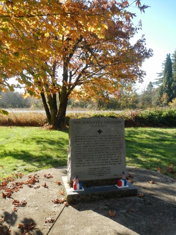
Near Camp Adair Road near Pacific Highway West (Oregon Route 99W), on the left when traveling east.
Activated on September 5, 1918 (World War I). Demobilized January 7, 1919. Became Oregon's Reserve Division in 1923. Activated to active duty August 15, 1942 at Camp Adair with orders to be Combat Ready as soon as possible. Trained at Camp Adair, . . . — — Map (db m114386) HM WM
The Quest symbolizes Alice E. Biddle, who in 1870 became the first woman to graduate from what is now Oregon State University. It reflects the energy, dedication and strength of all students in the pursuit of learning. — — Map (db m113343) HM
On SW Avery Park Drive, on the left when traveling east.
(Seven panels dealing with topics related to the Applegate Trail are found at this kiosk.)
Applegate Trail
Southern Route to Oregon
In 1846, Jesse Applegate and fourteen others from near Dallas, Oregon, established a . . . — — Map (db m116846) HM
Built in 1888-89, the Benton County Courthouse is the oldest building in Oregon still being used for its original purpose.
The courthouse was designed by Delos D. Neer, a prominent Portland architect, in a style he described as resembling . . . — — Map (db m107360) HM
On SW Madison Avenue, on the right when traveling west.
The Benton County State Bank building was dedicated on July 25, 1907. The bank, built on the ruins of a burned saloon, was representative of a period of growth and prosperity in Corvallis at the beginning of the 20th century.
Corvallis' . . . — — Map (db m117442) HM
Near Camp Adair Road near Pacific Highway West (Oregon Route 99W), on the left when traveling east.
The US War Department ultimately selected 55,000 acres at this location for an infantry training site in 1941. Temporary quarters were constructed, and the site was dedicated as Camp Adair in 1942. Camp Adair was designed to train two divisions at . . . — — Map (db m114382) HM
On Southwest Madison Avenue at Pacific Hwy W (U.S. 20), on the right when traveling east on Southwest Madison Avenue.
The Corvallis City Hall was located on the southeast corner of Fourth and Madison Streets from 1892 to 1956. This grand brick and stone building with the imposing belltower housed the City Council Chambers, and in addition, provided much of the . . . — — Map (db m112916) HM
On SW 1st Street north of SW Jefferson Avenue, on the right when traveling north.
The banks of the Willamette River were the focus of early town development. The town plat for Marysville was files on February on February 25, 1851, by Joseph C. Avery, using a portion of his land claim of 1845. The town included property from . . . — — Map (db m117488) HM
On SW Campus Way 0.5 miles west of SW 35th Street, on the left when traveling west.
The Reach
The Agricultural Reach of Oak Creek drains the croplands and research farm facilities of OSU. The Department of Animal Science manages these agricultural lands. Pastures are used for seasonal grazing and production of hay and . . . — — Map (db m108388) HM
The Episcopal Diocese of Oregon established the first school in the Central Park area. Dr. William Graham, a local physician, donated four lots on the block bounded by Madison, Monroe, Seventh, and Eighth Streets. He stipulated that the building . . . — — Map (db m117365) HM
On SW 8th St at SW Madison Ave, on the right when traveling north on SW 8th St.
The First Congregational Church was built here in 1917 to serve a congregation that had outgrown its original 1889 building at Third and Jefferson streets. Designed by architect Roy Dobell, a former instructor at Oregon Agricultural College (OAC, . . . — — Map (db m117268) HM
On SW Madison Ave at SW 8th St, on the right when traveling west on SW Madison Ave.
Fred J. Porter was the great-grandson of Benton County pioneer, Johnson Mulkey.
In the winter of 1845, Mulkey filed a land claim for 640 acres along Oak Creek, on the north side of Baldy Mountain. This was only a few months after Joseph Conant . . . — — Map (db m117266) HM
On Southwest Monroe Avenue, on the left when traveling west.
Mechanical Hall
This structure was built in 1899 to replace the original Mechanical Hall that burned to the ground on September 27, 1898. That fire threw the school year into chaos, since the building had housed the entire engineering program . . . — — Map (db m112864) HM
This is one of the first mill stones or burns to be used in this section of Oregon. This was originally quarried in France and shipped around the horn from New York in 1850 by sailing vessel. In 1852, was transported by oxen team from Portland to . . . — — Map (db m116840) HM
On Southwest Madison Avenue at SW 2nd St, on the left when traveling east on Southwest Madison Avenue.
The L.G. Kline Building was built in 1889 for Lewis G. Kline after his successful career as a dry goods merchant in Corvallis.
Kline, a Polish immigrant, came to Corvallis with his wife, Adaline, a Russian immigrant, in 1864. The Klines and . . . — — Map (db m112915) HM
On SW Madison Ave, on the left when traveling north.
In 1973, Dr. Robert MacVicar, president of Oregon State University, and Gene Hansen, president of the Corvallis Chamber of Commerce, discusses the need to develop a stronger connection between the university and downtown, especially for . . . — — Map (db m117364) HM
On SW Campus Way 0.5 miles west of SW 35th Street, on the left when traveling west.
A Watershed
A watershed is an area of land from which water drains and flows into a river and its tributaries. Small watersheds, such as Oak Creek’s, become part of larger watersheds when their streams converge. Thus, Oak Creek‘s . . . — — Map (db m108389) HM
On SW Jefferson Way at SW 15th Street, on the right when traveling west on SW Jefferson Way.
On October 27, 1868, the small institution of higher education known as Corvallis College was granted a charter by Oregon's legislative assembly designating it as the state's land grant institution under the provisions of the federal 1862 Morrill . . . — — Map (db m108382) HM
World War I plaque
In Memory of
Earl Blackden
Owen Johnson
R K Wilmot
Foresters Who
Fell in the
World War
1917-1918
World War II plaque
In Memory Of O. S. C.
Foresters
Who Lost Their Lives
In World War II . . . — — Map (db m113266) WM
On SW 1st Street north of SW Jefferson Avenue, on the right when traveling north.
The first steamboat to reach Corvallis was the sidewheeler Canemah in October of 1851. With this arrival, Corvallis joined Oregon's steamboat era, with tis stories of risk, profit, rivalries, mergers, heroics, innovation and disasters. . . . — — Map (db m117465) HM
Site of the earliest boat landing Lower Town, Marysville, 1851 Presented to City of Corvallis, Oregon Centennial Celebration, June 1957 by the Winema Chapter Daughters of the American Revolution — — Map (db m107333) HM
On SW Campus Way 0.5 miles west of SW 35th Street, on the left when traveling west.
Agricultural Users
This portion of the Oak Creek watershed is managed as a working agricultural laboratory. Agricultural users include the OSU Dairy Center, beef and sheep production barns, and the Veterinary Medicine Research Farm . . . — — Map (db m108387) HM
On SW Madison Ave, on the left when traveling north.
The Corvallis Arts Center building began its life as an Episcopal church, constructed in in 1889 just a block south of here. It was one of the products of the influential English emigrants who arrived in Benton County in the late 1800s under the . . . — — Map (db m117279) HM
Ferry service across the Willamette River was established by William F. Dixon, co-founder of Corvallis, in 1848. The service continued for 65 years until the opening of the Van Buren Street Bridge in 1913.
In the 1860s, the ferry was operated . . . — — Map (db m117447) HM
On SW Washington Avenue at SW 8th Street, on the right when traveling east on SW Washington Avenue.
The Incubator House and Poultry Building stood at 26th and Jefferson on the OAC (Oregon Agricultural College, now OSU) campus until 1927, where they formed the headquarters of the Department of Poultry Husbandry.
The Incubator House was the . . . — — Map (db m117612) HM
On Pacific Highway West at Pacific Hwy W (U.S. 20) on Pacific Highway West.
The Opera House was built on this site in 1870. It was a wooden building with a porch and covered entrance which faced on Fourth Street. The residents of Corvallis raised the money by subscription and donated their labor to build it. Inside there . . . — — Map (db m112917) HM
On Camp Adair Road near Pacific Highway West (Oregon Route 99W).
The 104th Infantry Division was activated on 15 September 1942, at Camp Adair and was named "The Timberwolves." After 18 months of training at Camp Adair and maneuvers in Eastern Oregon and the California-Arizona desert, they moved to Camp Carson, . . . — — Map (db m114384) HM WM
Near Camp Adair Road near Pacific Highway West (Oregon Route 99W), on the left when traveling east.
The 70th Infantry Division was activated on 15 June 1943 as "Oregon's Own" and was named "The Trailblazers" in honor of the Oregon Trail Centennial. After a year of training here at Camp Adair the Division moved to Ft. Leonard Wood, Missouri for . . . — — Map (db m114383) HM WM
Near NE 1st Street south of NW Harrison Boulevard.
The Van Buren Street Bridge is Oregon's only remaining example of a movable bridge built using the rare pin-connected truss technology. The use of pins, or bolts, connecting each truss point allowed the bridge to be easily assembled on site after . . . — — Map (db m117491) HM
On Pacific Hwy W (U.S. 99) at SW Madison Ave, on the right when traveling north on Pacific Hwy W.
The Whiteside Theatre opened on November 9, 1922. That evening, the audience enjoyed the silent picture “The Old Homestead,” accompanied by Lilian McElroy on a $20,000 two manual, double touch Wurlitzer organ. That organ was the largest, and the . . . — — Map (db m117434) HM
Near Camp Adair Road near Pacific Highway West (Oregon Route 99W), on the left when traveling east.
The 91st Infantry Division was originally activated 5 September 1917 at Camp Lewis, Washington and designated the "Wild West Division." The battle cry "Powder River! Let'er Buck!" was adopted in 1918. During World War I the division fought in the . . . — — Map (db m114385) HM WM
In June 1846 Jesse Applegate, Levi Smith and 11 other men left their homes near Dallas Oregon to develop a southern route from Fort Hall (Idaho) to the Willamette Valley. Their route passed through the gap west of Pigeon Butte, then proceeded . . . — — Map (db m119068) HM
On Bellfountain Rd, on the left when traveling south.
On this knoll stood Ebenezer School-
house, built in 1850. The first school
in the historic Belknap settlement, it was
also used for Methodist Sunday school
and class meetings.
In 1854, the second Methodist Conference
on the West . . . — — Map (db m119276) HM
On Pacific Hwy (U.S. 99) at Main Street, on the right when traveling south on Pacific Hwy.
(Two interpretive displays are located here next to the South Benton Community Museum):
(First Display)
In 1846, Jesse Applegate and fourteen others from near Dallas, Oregon, established a trail south from the Willamette Valley and . . . — — Map (db m116837) HM
United Methodist
Historic Site
No. 323
In memory of the pioneers of the Belknap Settlement who served God faithfully in an untamed land — — Map (db m122508) HM
On Pacific Hwy W (Oregon Route 99), on the right when traveling west.
This variable pitch water wheel was installed in the Long Tom River in 1906 to power the grain & flour machinery at the Adam Wilhelm Flour Mill. It also powered an electric generator that was later installed to provide electricity to the mill & the . . . — — Map (db m119283) HM
On Corvallis-Newport Highway (aka Main Street) (U.S. 20) at South 11th Street, on the right when traveling west on Corvallis-Newport Highway (aka Main Street).
Philomath College was chartered November 1865, as the United Brethren School for Oregon, Washington, Idaho, Montana and California. The name combines two Greek words meaning love of learning. The building’s center structure was completed in . . . — — Map (db m122509) HM
On Mt. Union Avenue, on the right when traveling north.
On May 11, 1861 Reuben and Mary Jane
Holmes Shipley, former negro slaves,
deeded from their farm purchased from
Charles Bales’ donation land claim, the
original plot for this cemetery.
Buried in Lot 10 are Reuben Shipley, Mary
Jane Shipley . . . — — Map (db m118083) HM
Near Mount Union Avenue north of Benton View Drive, on the right when traveling north.
During the first year of the Civil War, Reuben and Mary Jane Shipley donated land to establish this cemetery for the burial of both black and white people. The Shipleys were former enslaved laborers who arrived by wagon with their owners. Mary . . . — — Map (db m234519) HM
On James Street 0 miles east of Newton St, on the left when traveling east.
Mount Union Cemetery is situated on Reuben and Mary Jane Shipley, one of Oregon's earliest Black pioneer couples. Reuben was born into slavery in Kentucky and was brought to Oregon by his enslaver, Robert Shipley, in 1853. In return for driving . . . — — Map (db m234513) HM
On SE Main Street north of Clackamas Highway ( Highway 211), on the right when traveling south.
In remembrance of
Harold E. Babcock
Eagle Scout, WW II Veteran,
Educator, and Master Mason
Mr. Babcock kept the flags
in Estacada flying for 20 years! — — Map (db m8745) HM
On Old Barlow Road near Barlow Road (Forest Road NF-3530), on the left when traveling east.
This mountain pass in named for Samuel K. Barlow who opened the first wagon route over the Cascades in 1846 to complete the Oregon Trail. The route was far from easy. Emigrant Isom Cranfill (cabinet maker, farmer, and itinerant preacher) made the . . . — — Map (db m112383) HM
On East Perry Vickers Road near East Chimney Rock Road, on the left when traveling south.
Imagine feeding your hungry children and skinny ox teams whottleberries here. Helping you spouse repair your tired wagon for tomorrow's dreaded drop down Laurel Hill. Rain clouds gather around Mount Hood's peak. More storms coming. And they say the . . . — — Map (db m112373) HM
Near Mt. Hood Highway (Oregon Route 35), on the right when traveling east.
In 1924 engineers constructing the first Mt. Hood Highway discovered a gravesite here. The grave was marked with an old wooden wagon tongue buried beneath decades of overgrown brush. When they dug up the site, they found the remains of an . . . — — Map (db m113603) HM
On Barlow Road at Forest Road NF-3530, on the right when traveling east on Barlow Road.
First Road built over Cascade Range in 1845-1846 by
Samuel K. Barlow (1792-1867)
an Oregon Pioneer from Kentucky
Wamic -- Miles 32
Dalles California Highway -- Miles 38
Maupin -- Miles 48 — — Map (db m112396) HM
On Government Camp Loop near East Wyeast Trail, on the right when traveling west.
Village of
Government Camp
formerly a camp on the old Barlow Road, the village was named in 1849 when US Cavalry troops were forced to abandon wagons and supplies here. — — Map (db m112337) HM
On Government Camp Loop near 2nd Street, on the left when traveling west.
Village of
Government Camp
Formerly a camp on the old Barlow Road was named in the fall of 1849 when the first United States Mounted Rifles abandoned a large number of wagons here, while a detachment was traveling from The Dalles to . . . — — Map (db m112338) HM
On Government Camp Loop at 2nd Street (East Little Trail), on the right when traveling west on Government Camp Loop.
Samuel Kimbrough Barlow
Oregon Pioneer from Kentucky
Built the first wagon road across
Cascade Mountains
passing this spot
1845 - 1846
The building of railways . . . — — Map (db m241048) HM
dedicated September 28, 1937 by
Franklin D. Roosevelt
President of the United States
as a monument to the skill and faithful performance of workers on the rolls of the Works Progress Administration — — Map (db m112336) HM
In memory of the 304th Rescue Squadron aircrew members, who lost their lives on board aircraft King 56, while performing a training mission on the night of November 22, 1996. These men were Citizen Soldiers committed to the preservation of the . . . — — Map (db m11977) HM
On Wilbur Street at Durham Street, on the left when traveling east on Wilbur Street.
George M. Rogers purchased this lot in 1918 and lived in its existing small house until 1929, when he engaged Van Evera Bailey, a noted Portland architect, to design this unique Arts and Crafts/Mediterranean style residence. Exterior is . . . — — Map (db m119859) HM
On Green Street at Furnace Street on Green Street.
Henry Dodge Green and his brother John Green came to Oregon from New York in 1852. In partnership with H. C. Leonard, the Green brothers procured the gas and water franchises for the City of Portland. The cost of shipping cast-iron gas and water . . . — — Map (db m116109) HM
This cottage is the last survivor of cottages built for workers in Oswego's iron industry. It was probably built in the late 1870s or early 1880s by Albert Clinefelter or Lucien Davidson, local carpenters who constructed many buildings for the . . . — — Map (db m120039) HM
On South State Street at Middlecrest Road, on the right when traveling south on South State Street.
On this site in 1893, Oswego's first public school was built and served the children of the town until it was outgrown, and replaced in 1928 by this handsome Colonial Revival style structure. Originally called Oswego Grammar School, it was renamed . . . — — Map (db m116105) HM
On Old River Road east of Green Street, on the left when traveling south.
"Charcoal haulers would cross the covered bridge and follow the trail along the river...."
Mary Goodall, Oregon's Iron Dream, (1958, p. 76)
At least four bridges have been built at the mouth of Oswego Creek and adjacent to Oswego . . . — — Map (db m116051) HM
On North State Street 0.1 miles south of A Avenue, on the left when traveling south.
This Arts and Crafts style building was constructed in 1940 as the Murphy Real Estate office. It is one of a cluster of buildings on State Street designed by the prominent local architect, Richard Sundeleaf. The half-timbered architecture was . . . — — Map (db m116518) HM
On Wilbur Street at Durham Street, on the right when traveling east on Wilbur Street.
Albert Alonzo Durham filed the first donation land claim here in 1850, naming the place Oswego after his New York home town. In 1864 John Corse Trullinger bought Durham's sawmill on Sucker Creek, and in 1866 this 87-acre portion of land, Trullinger . . . — — Map (db m117168) HM
In the early 19th century, the river landing at the mouth of Oswego Creek was a convenient camping place for explorers, fur traders, and pioneers. In the words of one old timer, it was "a stopping place, a sort of a relay station for boats both . . . — — Map (db m121328) HM
This mass of solidified iron from the hearth of the Oswego furnace is known as a 'Salamander'. It is named after a mythological amphibian that lived in fire. Salamanders often formed in the bottom of 19th Century iron furnaces and were removed, with . . . — — Map (db m116143) HM
On McVey Avenue west of South State Street, on the right when traveling west.
On this site Oswego's first industry, a saw mill, was established in 1850 by Albert Alonzo Durham on this portion of his 637 acre Donation Land Grant which included "Old Town" and much of East Oswego. He advertised his new mill in the . . . — — Map (db m117224) HM
In Prehistoric Times
Fifteen thousand years ago, the mouth of the Tualatin River was located at Like Oswego. The river's course changed when the cataclysmic Missoula floods poured down the Columbia Basin and inundated the Willamette Valley. . . . — — Map (db m120526) HM
Ikanum are traditional stories. One such story from Victoria Howard of Grand Ronde is told about the area around Lake Oswego. The story tells of a particularly hostile winter, in which cold and starvation threatened the entire village of . . . — — Map (db m116145) HM
Originally called Green Point, Indians gathered here for over 3,000 years to fish at Willamette Falls.
George Abernethy arrived here June 2, 1840, with the "Great Reinforcement" of Jason Lee's Willamette Mission. He took 640 acres just north . . . — — Map (db m286204) HM
Near Washington Street, on the right when traveling north.
"When woman's true history shall have been written, her part in the upbuilding of this nation will astound the world." -- Abigail Scott Duniway, Path Breaking (1914)
The third in a family of fourteen, Abigail "Jenny" Scott traveled west . . . — — Map (db m114173) HM
Near South Gronlund Road near Carver Road, on the right when traveling west.
Commerce came quickly to the area as pioneers cleared land and became established. Pasture and grazing was common but presented transportation problems before refrigeration and good roads or bridges. The Clear Creek Creamery co-op was formed to . . . — — Map (db m114236) HM
Near South Gronlund Road near Carver Road, on the right when traveling west.
Welcome to the Baker Cabin Historical Site. This is one panel of many that are spaced throughout the site. You are invited to see them all. The Baker Cabin Historical Society is the present day organization founded from the Old Timers Association of . . . — — Map (db m114257) HM
On South Gronlund Road near Carver Road, on the right when traveling west.
This marker is located on the grounds of Baker Cabin Historical Site.
Oregon Trail emigrants left established homes and farms in the East to start anew in the wilderness that was the Oregon Country. Emigrants packed simple farm wagons with enough . . . — — Map (db m114232) HM
Near South Gronlund Road near Carver Road, on the right when traveling west.
The Baker's water supply consisted of a hand dug well located close to the cabin. Likely located by dowsing , there is a strong underground stream easily found even today with a 'water-witch.' The well extended down approximately 25 feet and often . . . — — Map (db m114256) HM
On 3rd Avenue at Hedges Street, on the right when traveling west on 3rd Avenue.
Before the coming of the white immigration, the flat area above the falls was a native encampment called "Kanim" or "Canoe Place". In 1844 Absolom Hedges staked out a donation land claim and platted it in 1849 naming the area Falls City. The first . . . — — Map (db m114029) HM
Near Washington Street near Abernethy Road, on the right when traveling north.
About four miles below Oregon City the Klackamass enters the Walhamettee: and, seated below the banks at its mouth, I saw a party of Indians of the Klackamass tribe, and I put ashore for the purpose of taking a sketch of them.
They were busy . . . — — Map (db m114759) HM
Near Washington Street near Abernethy Road, on the right when traveling north.
"Let us make a waterfall across the river." Meadowlark said to Coyote. So they made a rope by twisting young hazel shoots.
Holding one end of the rope, Meadowlark went on one side of the Willamette River; holding the other end, coyote went on the . . . — — Map (db m114060) HM
Near Washington Street near Abernethy Road, on the right when traveling north.
Coyote came to that place around Oregon City and found the people there very hungry. The river was full of salmon, but they had no way to spear them in the deep water. Coyote decided he would build a big waterfall, so that the salmon would come to . . . — — Map (db m114061) HM
Dr. Forbes Barclay left Scotland in 1839 for Fort Vancouver (Washington) where he became chief physician for Hudson's Bay Company. He moved to Oregon City in 1850 where he practiced medicine for many years. He was one of Oregon City's early mayors, . . . — — Map (db m8692) HM
On McLoughlin Boulevard (Oregon Route 99) at S. 2nd Street, on the right when traveling south on McLoughlin Boulevard.
Born in Riviere du Loup, Canada, October 19, 1784.
1824 Came to the Oregon Country as Chief Factor of the Columbia Department of the Hudson's Bay Company.
1829 Located his claim to the present site of Oregon City.
1845 Resigned his . . . — — Map (db m8699) HM
On Centre Street at 7th Street, on the left when traveling north on Centre Street.
Chief Factor, 1821-1845, and Superintendent of the Columbia Department, 1824-1821, of the Hudson's Bay Company, laid claim to and took possession of the Site of Oregon City in 1829.
In 1842 he had the site surveyed, and subsequently dedicated . . . — — Map (db m114027) HM
Near Washington Street near Abernethy Road, on the right when traveling north.
"He stood among his pioneer contemporaries like towering old (Mount) Hood ... a born leader of men." -- Willard H Res, description of John McLoughlin during speech, 1879
His personality was measured in patience, generosity, . . . — — Map (db m114065) HM
Near Washington Street near Abernethy Road, on the right when traveling north.
It must have been long long ago that the earth shook. Then they would get their wooden pans and buckets, they would turn them upside down there, and they would sing and make a racket. They would say in their singing,
Put by the side of the . . . — — Map (db m114168) HM
Near Washington Street near Abernethy Road, on the right when traveling north.
Here the Pioneers Ended Their
Journey West.
Abernethy Green is the Official
End of the Oregon Trail,
As Designated by the U.S. Congress
In 1978.
Placed in Honor
of the Pioneer Achievements of
Dan Fowler
Oregon . . . — — Map (db m114198) HM
Near Washington Street near Abernethy Road, on the right when traveling north.
Oregon City, Western Terminus of the Oregon Trail
(about 2200 miles from Independence, MO)
Here at Abernethy Green in the fall of 1845, members of the Barlow-Palmer-Rector Wagon Train entered Oregon City as best they could. Pioneering a . . . — — Map (db m114199) HM
In memory of Eva Emery Dye and others who saved the McLoughlin House from demolition in 1909. The house was moved down Main Street and up Singer Hill to open as a museum on this location in 1910. Mrs. Dye was the author of “McLoughlin and Old . . . — — Map (db m8698) HM
Near Washington Street near Abernethy Road, on the right when traveling north.
Since time immemorial, Willamette Falls (Tumwater) has been an important fishing site for the Clowewalla (also known as the Willamette Tumwater) and Clackamas Chinook peoples. They controlled access to the falls through inter-tribal relationships . . . — — Map (db m114172) HM
Near Washington Street near Abernethy Road, on the right when traveling north.
"We pitched our tent... remaining at this camp for about one week, feasting on watermelons and good, fresh vegetables right from the garden, which are brought in by the Clackamas County farmers in great abundance." E.W. Conyers on arrival in . . . — — Map (db m114201) HM
Near Washington Street near Abernethy Road, on the right when traveling north.
George Abernethy who arrived at Willamette Falls in 1840 by ship, took a land claim that stretched from the Willamette River to Holcomb Hill. The neck of land that followed Abernethy Creek across Green Point became known as Abernethy Green. . . . — — Map (db m286194) HM
Native Americans are understood to have used this large rock for grinding acorns, nuts, or grains, and preparing other foods. The several holes are evidence of long term use. This rock may have been close to Native American encampments located near . . . — — Map (db m114255) HM
On 5th Avenue near Blanchard Street, on the right when traveling west.
In 1864 Absolom Hedges donated 1.91 acres for a cemetery. By 1865 the Canemah Cemetery Association was formed and received a deed. In 1883 the Rhinehart family donated a 30 ft. wide roadway to 5th Avenue. In 1914 the cemetery was surveyed and iron . . . — — Map (db m114028) HM
On Main Street at 6th Street, on the right when traveling south on Main Street.
The oldest brick commercial building remaining in downtown Oregon City
early tenants were J Myers & Co
"Cheap Cash Store" (1865-1888)
Clackamas County Courthouse (1865-1885)
Oregon City Enterprise (1880-1919)
the Bank of Oregon City . . . — — Map (db m288863) HM
On McLoughlin Boulevard (Pacific Highway) (State Highway 99) at 6th Street on McLoughlin Boulevard (Pacific Highway).
Born in Washington Co. Va., Meek leaves home at age 18, arriving in St. Louis in the fall of 1828. Meek signs on as a trapper with the Rocky Mtn. Fur Co., remaining in the Rockies until 1839.
1839 - 1843: Meek travels to the Willamette Valley . . . — — Map (db m8673) HM
Near Tumwater Drive at S. 2nd Street, on the right when traveling south.
Born in Oregon City
June 10, 1949
Killed in Action
February 23, 1971
Vice President Ford of the United States of America awarded posthumously in the name of Congress
The Medal of Honor
for conspicuous gallantry & intrepidity in . . . — — Map (db m8711) HM
Near Washington Street near Abernethy Road, on the right when traveling north.
Lot Whitcomb, proprietor of the town, gave two lots and an unfinished building that had cost him about $1,000 - the first Episcopal church building in Oregon.
His wife, Irene, suffered from asthma. Believing Oregon a healthy place, in . . . — — Map (db m114171) HM
On this site was an early firehall. Current structure was built as City Hall housing city offices, Police Dept., and the jail, all of which remained until the mid 40s. Oregon City Beauty School occupied main floor and basement for 22 years. Jail . . . — — Map (db m8747) HM
In the city he founded, in this house he built, lived Dr. John McLoughlin, 1846-57.
He won enduring fame for his generous and humane aid to early American settlers in the Oregon Country, as Chief Factor and Superintendent of the Hudson’s Bay . . . — — Map (db m8693) HM
Near Washington Street near Abernethy Road, on the right when traveling north.
"A few of us (went) to the Falls of Willamut where we found many people & considerable of business." Medorem Crawford, Journal, October 3, 1842
An emigrant of 1842, Medorem Crawford worked for nearly a decade hauling freight around . . . — — Map (db m114760) HM
On Main Street near 7th Street, on the right when traveling west.
Built by Ed Johnson as a full service barber shop with 4 chairs and bathing facilities. Basement still has massive brick boiler for hot water originally fired by sawdust from local mill. Converted to restaurant in 1986. — — Map (db m8746) HM
Near Washington Street near Abernethy Road, on the right when traveling north.
"We claim that country - for what? To make the wilderness blossom as the rose, to establish laws, to increase, multiply, and subdue the earth..." -- John Quincy Adams, Congressional Globe, February 9, 1846
Arguing that God had manifestly . . . — — Map (db m114064) HM
On McLoughlin Boulevard (Oregon Route 99) near S. 2nd Street, on the right when traveling south.
Oregon City - supply point for pioneer emigrants was first located as a claim by Dr. John McLoughlin in 1829. The first provisional legislature of the Oregon Country was held here in 1843 and land and tax laws formulated. Oregon City was the . . . — — Map (db m8700) HM
480 entries matched your criteria. The first 100 are listed above. Next 100 ⊳