1039 entries match your criteria. The first 100 are listed. ⊳
Historical Markers and War Memorials on Tampa Bay Region
By Tim Fillmon, November 8, 2017
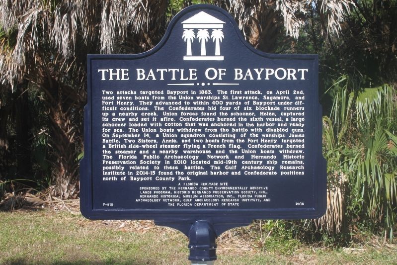
Bayport in the Civil War/The Battle of Bayport Marker Side 2
1 ► Florida, Hernando County, Bayport — F-915 — Bayport in the Civil War / The Battle of Bayport —  |
| Near Cortez Boulevard (County Road 550) 1.5 miles south of Pine Island Drive. | |||
| 2 ► Florida, Hernando County, Bayport — F-789 — Bayport's Early Historic Period/Post Civil War Era — |
| Near Cortez Boulevard (County Road 550) 6.5 miles west of Commercial Way (U.S. 19), on the right when traveling west. | |||
| 3 ► Florida, Hernando County, Bayport — F-788 — The Bayport Area Before Human Occupation/Bayport's First People — |
| Near Cortez Boulevard (County Road 550) 6.5 miles west of Commercial Way (U.S. 19). | |||
| 4 ► Florida, Hernando County, Brooksville — F-1174 — 1885 Train Depot — |
| On Russell Street 0.1 miles west of South Brooksville Avenue, on the right when traveling east. | |||
| 5 ► Florida, Hernando County, Brooksville — F-1181 — Brooksville Army Airfield Gunnery Backstop — |
| On Aviation Loop Drive at Sam Pearson Way, on the right when traveling west on Aviation Loop Drive. | |||
| 6 ► Florida, Hernando County, Brooksville — F-1284 — Chinsegut Hill — |
| Near Chinsegut Hill Road 0.3 miles west of Snow Memorial Highway. | |||
| 7 ► Florida, Hernando County, Brooksville — F-510 — Chinsegut Hill |
| On Chinsegut Hill Road at Snow Memorial Highway, on the right when traveling west on Chinsegut Hill Road. Reported permanently removed. | |||
| 8 ► Florida, Hernando County, Brooksville — F-802 — Chocochatti — |
| On Cortez Boulevard (State Road 50) 0.2 miles west of East Jefferson Street (U.S. 98), on the right when traveling east. | |||
| 9 ► Florida, Hernando County, Brooksville — City of Brooksville — Founded 1856 - Incorporated October 13, 1880 — |
| On Howell Avenue north of West Fort Dade Avenue, on the left when traveling north. | |||
| 10 ► Florida, Hernando County, Brooksville — F-75 — Hernando County — |
| On North Main Street north of Broad Street (U.S. 98), on the right when traveling north. | |||
| 11 ► Florida, Hernando County, Brooksville — Hernando County Confederate Monument — |
| On North Main Street at North Broad Street (U.S. 98), on the left when traveling south on North Main Street. | |||
| 12 ► Florida, Hernando County, Brooksville — Hernando County Global War on Terrorism Memorial — |
| On North Main Street at East Jefferson Street, on the right when traveling north on North Main Street. | |||
| 13 ► Florida, Hernando County, Brooksville — Hernando County War Memorial — |
| On North Main Street north of Broad Street (U.S. 98), on the right when traveling north. | |||
| 14 ► Florida, Hernando County, Brooksville — Historic Sidewalk — |
| On Russell Street just west of South Brooksville Avenue, on the left when traveling west. | |||
| 15 ► Florida, Hernando County, Brooksville — Saint Stanislaus Chapel — Established 1915 — |
| On Citrus Way (County Road 491) south of Ponce de Leon Boulevard (U.S. 98), on the right when traveling south. | |||
| 16 ► Florida, Hernando County, Brooksville — St. Anthony the Abbot Church — Established 1892 — Oldest Catholic Parish in Hernando County — |
| Near Cortez Boulevard (State Road 50) at Hope Hill Road, on the right when traveling east. | |||
| 17 ► Florida, Hernando County, Brooksville — F-471 — The Grave of Charlotte Wynn Pyles Crum — |
| Near Olmes Road 0.1 miles west of Jasmine Drive. | |||
| 18 ► Florida, Hernando County, Garden Grove — F-1052 — Garden Grove — |
| On Broad Street (U.S. 41) at Stromberg Avenue, on the right when traveling north on Broad Street. | |||
| 19 ► Florida, Hernando County, Istachatta — 12 — Pressing Onward — Florida De Soto Trail — July 23, 1539 — |
| Near Lake Lindsey Road (County Road 476) 0.1 miles east of Lingle Road (County Road 439), on the left when traveling east. | |||
| 20 ► Florida, Hernando County, Masaryktown — F-426 — Masaryktown — |
| On Broad Street (U.S. 41) at Wilson Boulevard, on the right when traveling north on Broad Street. | |||
| 21 ► Florida, Hernando County, Richloam — F-994 — Richloam General Store and Post Office — |
| On Richloam-Clay Sink Road at Riverland Road, on the left when traveling south on Richloam-Clay Sink Road. | |||
| 22 ► Florida, Hernando County, Richloam — 11 — Rumors of Riches — Florida De Soto Trail — July 20, 1539 — |
| Near Richloam Clay Sink Road 0.1 miles east of Riverland Road, on the right when traveling east. | |||
| 23 ► Florida, Hernando County, Ridge Manor — Florida Honors and Remembers our POWs and MIAs — |
| Near Interstate 75 at milepost 307, 8.9 miles north of Cortez Blvd (U.S. 98), on the left when traveling north. | |||
| 24 ► Florida, Hernando County, Ridge Manor — F-247 — Fort King Road — |
| On Cortez Boulevard (State Road 50) at Treiman Boulevard (U.S. 301), on the right when traveling east on Cortez Boulevard. | |||
| 25 ► Florida, Hernando County, Spring Lake — Spring Lake Community Center — 1938 — |
| On Spring Lake Highway (County Road 541) south of Old Spring Lake Road, on the right when traveling north. | |||
| 26 ► Florida, Hernando County, Webster — F-1005 — Richloam — |
| On Richloam-Clay Sink Road 0.1 miles south of Riverland Road, on the right when traveling south. | |||
| 27 ► Florida, Hernando County, Weeki Wachee — Bayport — |
| On Cortez Boulevard, on the right when traveling south. | |||
| 28 ► Florida, Hernando County, Weeki Wachee — F-939 — Town of Centralia — |
| On Commercial Way (U.S. 19) 0.1 miles north of Centralia Road (County Road 476), on the right when traveling north. | |||
| 29 ► Florida, Hillsborough County, Apollo Beach — A Butterfly’s Habitat — |
| On Dickman Rd. | |||
| 30 ► Florida, Hillsborough County, Apollo Beach — Do You See a Manatee? — |
| On Dickman Rd. | |||
| 31 ► Florida, Hillsborough County, Apollo Beach — Listen carefully to hear a manatee! — |
| On Dickman Rd. | |||
| 32 ► Florida, Hillsborough County, Apollo Beach — Long-Legged Wading Birds Stalk the Shallows — |
| On Dickman Rd. | |||
| 33 ► Florida, Hillsborough County, Apollo Beach — Manatee Scar Identification — |
| On Dickman Rd. | |||
| 34 ► Florida, Hillsborough County, Apollo Beach — Storm Water and the Estuary — |
| On Dickman Rd. | |||
| 35 ► Florida, Hillsborough County, Apollo Beach — The Life Cycle of the Monarch Butterfly — Dananus plexippus — |
| On Dickman Rd. | |||
| 36 ► Florida, Hillsborough County, Apollo Beach — What Role Do Mangroves Play In An Estuary? — |
| On Dickman Rd. | |||
| 37 ► Florida, Hillsborough County, Bealsville — Bealsville — |
| On Nesmith Road at Joe King Road, on the right when traveling west on Nesmith Road. | |||
| 38 ► Florida, Hillsborough County, Brandon — Memoria In Aeterna, 1911 — “In Eternal Remembrance,” 1911 — Hillsborough County's Confederate Monument — |
| On North Pinewood Avenue at East Brandon Boulevard (State Road 60), on the left when traveling north on North Pinewood Avenue. | |||
| 39 ► Florida, Hillsborough County, Brandon — Brandon Family Cemetery — |
| On North Pinewood Avenue north of East Brandon Boulevard (State Road 60), on the left when traveling north. | |||
| 40 ► Florida, Hillsborough County, Brandon — Brandon Homestead — |
| On Brandon Boulevard (State Road 60), on the right when traveling east. | |||
| 41 ► Florida, Hillsborough County, Brandon — Brandon Masonic Lodge No. 114, F. & A.M. — 1890-1990 — |
| On North Moon Avenue at West Morgan Street, on the right when traveling north on North Moon Avenue. | |||
| 42 ► Florida, Hillsborough County, Brandon — Brandon School — |
| On West Sadie Street at North Knights Avenue, on the right when traveling west on West Sadie Street. | |||
| 43 ► Florida, Hillsborough County, Brandon — Hillsborough County's Confederate Monument — Memoria In Aeterna — (In Eternal Remembrance) — |
| On East Brandon Boulevard (State Road 60) at North Pinewood Avenue, on the left when traveling east on East Brandon Boulevard. | |||
| 44 ► Florida, Hillsborough County, Brandon — Limona — Founded January 12, 1876 — |
| On Lakewood Drive at Limona Road, on the right when traveling north on Lakewood Drive. | |||
| 45 ► Florida, Hillsborough County, Brandon, Buckhorn Creek — Brandon — Established 1890 — |
| On Ronele Drive at South Kings Avenue on Ronele Drive. | |||
| 46 ► Florida, Hillsborough County, East Lake-Orient Park — 1958 Lebanon crisis — Hillsborough County Veterans Memorial Park — |
| Near U.S. 301 0.2 miles south of East Dr. Martin Luther King Jr. Boulevard, on the right when traveling south. | |||
| 47 ► Florida, Hillsborough County, East Lake-Orient Park — Boxer Rebellion 1898-1901 — Hillsborough County Veterans Memorial Park — |
| Near U.S. 301 0.2 miles East Dr. Martin Luther King Jr. Boulevard, on the right when traveling south. | |||
| 48 ► Florida, Hillsborough County, East Lake-Orient Park — Mayaguez Incident (1975) — Hillsborough County Veterans Memorial Park — |
| Near U.S. 301 0.2 miles south of East Dr. Martin Luther King Jr. Boulevard, on the right when traveling south. | |||
| 49 ► Florida, Hillsborough County, East Lake-Orient Park — The Philippine-American War 1899 - 1913 — Hillsborough County Veterans Memorial Park — |
| Near U.S. 301 0.2 miles south of East Dr. Martin Luther King Jr. Boulevard, on the right when traveling south. | |||
| 50 ► Florida, Hillsborough County, East Lake-Orient Park — United States occupation of the Dominican Republic (1916-1924) — Hillsborough County Veterans Memorial Park — |
| Near U.S. 301 0.2 miles East Dr. Martin Luther King Jr. Boulevard, on the right when traveling south. | |||
| 51 ► Florida, Hillsborough County, East Lake-Orient Park — United States occupation of the Dominican Republic (1965-1966) — Hillsborough County Veterans Memorial Park — |
| Near U.S. 301 0.2 miles south of East Dr. Martin Luther King Jr. Boulevard, on the right when traveling south. | |||
| 52 ► Florida, Hillsborough County, East Lake-Orient Park — United Task Force (1992-1993) — Hillsborough County Veterans Memorial Park — |
| On U.S. 301 0.2 miles south of East Dr. Martin Luther King Jr. Boulevard, on the right when traveling south. | |||
| 53 ► Florida, Hillsborough County, East Lake-Orient Park — US Army Howitzer 75mm — SN: 20543 Recoil # M1897A5 Barrel# M1897A4 — |
| Near U.S. 301 0.2 miles south of East Dr. Martin Luther King Jr. Boulevard, on the right when traveling south. | |||
| 54 ► Florida, Hillsborough County, East Lake-Orient Park — US Army Stuart M3A1 Light Tank — Hillsborough County Veterans Memorial Park — |
| Near U.S. 301 0.2 miles East Dr. Martin Luther King Jr. Blvd (Florida Route 574), on the right when traveling south. | |||
| 55 ► Florida, Hillsborough County, East Lake-Orient Park — USS Cole Bombing (2000) — Hillsborough County Veterans Memorial Park — |
| Near U.S. 301 0.2 miles south of East Dr. Martin Luther King Jr. Boulevard, on the right when traveling south. | |||
| 56 ► Florida, Hillsborough County, Lithia — Site of Alderman's Ford — First Crossing Point of the Alafia River in This Vicinity — |
| Near Aldermans Ford Park Drive 0.3 miles south of Plant City-Picnic Road (County Road 39). | |||
| 57 ► Florida, Hillsborough County, Lithia — Site of Fort Alafia — Indian War Stockade Built 1849 Community & Post Office Established 1855 — |
| Near Alderman Ford Park Drive at County Route 39, on the left when traveling south. | |||
| 58 ► Florida, Hillsborough County, Lutz — Old Lutz Elementary School — Erected 1927 — |
| On U.S. 41 at 4th Avenue SE, on the right when traveling north on U.S. 41. | |||
| 59 ► Florida, Hillsborough County, Lutz — Veterans Memorial — |
| On 1st Avenue SW at 1st Avenue SW, on the left when traveling north on 1st Avenue SW. | |||
| 60 ► Florida, Hillsborough County, Plant City — F-987 — Bing Rooming House — |
| On Allen Street at East Laura Street, on the right when traveling south on Allen Street. | |||
| 61 ► Florida, Hillsborough County, Plant City — Cow Cavalry — In Memory — Co. B 1st Battalion Fl. Special Cavalry C. S. A. |
| On North Collins Street at East Gilchrist Street, on the left when traveling north on North Collins Street. Reported permanently removed. | |||
| 62 ► Florida, Hillsborough County, Plant City — Echebucsassa Post Office — |
| On East Baker Street (U.S. 92) at North Gordon Street, in the median on East Baker Street. | |||
| 63 ► Florida, Hillsborough County, Plant City — Freedom Rising Monument — Veterans’ Memorial Monument Park — |
| On N. Wheeler Street at W. Damon Street, on the right when traveling north on N. Wheeler Street. | |||
| 64 ► Florida, Hillsborough County, Plant City — Glover School — Hillsborough County Historic Landmark — circa 1933 — |
| On Horton Road north of State Road 60, on the right when traveling north. | |||
| 65 ► Florida, Hillsborough County, Plant City — In Honor and Remembrance — |
| On North Collins Street at NE Drane Street, on the right when traveling south on North Collins Street. | |||
| 66 ► Florida, Hillsborough County, Plant City — Marine PFC Edward L. Wise — Veterans’ Memorial Monument Park — |
| Near N Wheeler Street at Damon Street. | |||
| 67 ► Florida, Hillsborough County, Plant City — 81000194 — Plant City High School — |
| On North Collins Street north of East Herring Street, on the left when traveling north. | |||
| 68 ► Florida, Hillsborough County, Plant City — Plant City Railroad Platform and Tower — |
| Near South Palmer Street at East Drake Street, on the right when traveling north. | |||
| 69 ► Florida, Hillsborough County, Plant City — 75000558 — Plant City Union Depot — |
| Near North Palmer Street near East North Drane Street, on the right when traveling north. | |||
| 70 ► Florida, Hillsborough County, Plant City — Robert E. “Roy” Parke — Veterans’ Memorial Monument Park — |
| Near North Wheeler Street at Damon Street. | |||
| 71 ► Florida, Hillsborough County, Plant City — Site of Methodist Episcopal Church South — 1885-1902 — |
| On West Dr Martin Luther King Jr Boulevard east of South Howard Street, on the left when traveling west. | |||
| 72 ► Florida, Hillsborough County, Plant City — Town of Plant City — Incorporated January 10, 1885 — |
| On Palmer Street east of East North Drane Street, on the right when traveling north. | |||
| 73 ► Florida, Hillsborough County, Plant City — Turkey Creek School — |
| On Turkey Creek Road at Connell Road, on the right when traveling south on Turkey Creek Road. | |||
| 74 ► Florida, Hillsborough County, Plant City — Veterans Memorial — Veterans’ Memorial Monument Park — |
| Near North Wheeler Street at Damon Street. | |||
| 75 ► Florida, Hillsborough County, Plant City — Veterans Memorial — Veterans’ Memorial Monument Park — |
| Near North Wheeler Street at Damon Street. | |||
| 76 ► Florida, Hillsborough County, Plant City — Veterans’ Memorial Monument Park — |
| Near North Wheeler Street at West Damon Street. | |||
| 77 ► Florida, Hillsborough County, Riverview — 5 — Saved from Slavery — Florida De Soto Trail — June 20, 1539 — |
| Near McMullen Road 0.9 miles south of Boyette Road, on the left when traveling south. | |||
| 78 ► Florida, Hillsborough County, Ruskin — Florida Honors and Remembers our POW’s and MIA’s — |
| Near Interstate 75 at milepost 238, 2.5 miles south of College Avenue (Florida Route 674), on the right when traveling south. | |||
| 79 ► Florida, Hillsborough County, Ruskin — Florida Honors and Remembers our POW's and MIA's — |
| On Interstate 75 1.8 miles south of College Avenue (Florida Route 674), on the right when traveling north. | |||
| 80 ► Florida, Hillsborough County, Ruskin — 3 — Landing in La Florida — Florida De Soto Trail — May 30, 1539 — |
| On Gulf City Road 0.2 miles north of Cockroach Bay Road, on the left when traveling north. | |||
| 81 ► Florida, Hillsborough County, Ruskin — Miracle at Cockroach Bay The Leisey Shell Fossils — |
| On Mammoth Trail 0.2 miles south of Gulf City Road, on the right when traveling south. | |||
| 82 ► Florida, Hillsborough County, Ruskin — F-246 — Ruskin College President's Home — |
| On South Tamiami Trail (U.S. 41) at 5th Avenue Southeast, on the right when traveling south on South Tamiami Trail. | |||
| 83 ► Florida, Hillsborough County, Ruskin — 4 — Staking Their Claim — Florida De Soto Trail — June 1, 1539 — |
| On E.G. Simmons Park Drive 3.2 miles west of South Tamiami Trail (U.S. 41). | |||
| 84 ► Florida, Hillsborough County, Seffner — Florida Militia Ambush |
| On East Hillsborough Avenue (U.S. 92) just east of Pasadena Drive, on the right when traveling west. Reported missing. | |||
| 85 ► Florida, Hillsborough County, St. Petersburg — Administration Building — Egmont Key State Park — |
| Near Anderson Boulevard (Florida Route 679) 1.5 miles west of Pinellas Bayway South, on the left when traveling west. | |||
| 86 ► Florida, Hillsborough County, St. Petersburg — Bakery — Egmont Key State Park — |
| Near Anderson Boulevard (Florida Route 679) 1.5 miles Pinellas Bayway South, on the left when traveling west. | |||
| 87 ► Florida, Hillsborough County, St. Petersburg — Battery Charles Mellon - 1898 — Egmont Key State Park |
| Near Anderson Boulevard (Florida Route 679) 1.5 miles west of Pinellas Bayway South, on the left when traveling west. Reported unreadable. | |||
| 88 ► Florida, Hillsborough County, St. Petersburg — Battery Guy Howard, 1906 — Egmont Key State Park — |
| Near Anderson Boulevard (Florida Route 679) 1.5 miles west of Pinellas Bayway South, on the left when traveling west. | |||
| 89 ► Florida, Hillsborough County, St. Petersburg — Cable Tank and Mine Storehouse — Egmont Key State Park — |
| Near Anderson Boulevard (Florida Route 679) west of 3500 Pinellas Bayway South, on the left when traveling west. | |||
| 90 ► Florida, Hillsborough County, St. Petersburg — Civil War Burials — Egmont Key Lighthouse Cemetery — Egmont Key State Park — |
| Near Anderson Boulevard (Florida Route 679) 1.5 miles Pinellas Bayway South, on the left when traveling west. | |||
| 91 ► Florida, Hillsborough County, St. Petersburg — Egmont Key Light — Egmont Key State Park — |
| Near Anderson Boulevard (Florida Route 679) 1.5 miles west of Pinellas Bayway South, on the left when traveling west. | |||
| 92 ► Florida, Hillsborough County, St. Petersburg — Egmont Key Lighthouse Cemetery — Egmont Key State Park — |
| Near Anderson Boulevard (Florida Route 679) 1.5 miles west of Pinellas Bayway South, on the left when traveling west. | |||
| 93 ► Florida, Hillsborough County, St. Petersburg — Egmont Key Train — Egmont Key State Park |
| Near Anderson Boulevard (Florida Route 679) 1.5 miles west of Pinellas Bayway South, on the left when traveling west. Reported unreadable. | |||
| 94 ► Florida, Hillsborough County, St. Petersburg — Fire Control Command Tower — Egmont Key State Park — |
| Near Anderson Boulevard (Route 679) 1.5 miles west of Pinellas Bayway South, on the left when traveling west. | |||
| 95 ► Florida, Hillsborough County, St. Petersburg — Fire Station - built 1910 - Cost $2,424.00 — Egmont Key State Park — |
| Near Anderson Boulevard (Florida Route 679) 1.5 miles Pinellas Bayway South, on the left when traveling west. | |||
| 96 ► Florida, Hillsborough County, St. Petersburg — First Light Tower Built In 1848 - Similar To This — Egmont Key State Park — |
| Near Anderson Boulevard (Florida Route 679) 1.5 miles west of Pinellas Bayway South, on the left when traveling west. | |||
| 97 ► Florida, Hillsborough County, St. Petersburg — Fog Bell — Egmont Key State Park — |
| Near Anderson Boulevard (Florida Route 679) 1.5 miles west of Pinellas Bayway South, on the left when traveling west. | |||
| 98 ► Florida, Hillsborough County, St. Petersburg — Foghorn — Egmont Key State Park — |
| Near Anderson Boulevard (Florida Route 679) 1.5 miles west of Pinellas Bayway South, on the left when traveling west. | |||
| 99 ► Florida, Hillsborough County, St. Petersburg — Fort Dade Mine Wharf — Egmont Key State Park |
| Near Anderson Boulevard (Florida Route 679) 1.5 miles west of Pinellas Bayway South, on the left when traveling west. Reported unreadable. | |||
| 100 ► Florida, Hillsborough County, St. Petersburg — Fort Dade Tennis Court — Egmont Key State Park — |
| Near Anderson Boulevard (Florida Route 679) 1.5 miles west of Pinellas Bayway South, on the left when traveling west. | |||
1039 entries matched your criteria. The first 100 are listed above. Next 100 ⊳