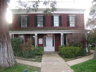
Near Church Street near North Street, on the right when traveling south.
Home (built 1859) of Armstead C. Brown (1816 – 1902) & son George until 1947. A.C. Brown was a lawyer, first president of Jackson City Trustees, state assemblyman 1863 – 66 & 1860 – 70, county judge 1876 – 78. Gave land to north for school purposes. . . . — — Map (db m27683) HM
On State Highway 49 at milepost 1.4, 2.5 miles south of State Route 88, on the left when traveling south.
Constructed by Italian stone mason in 1857. Served pioneer settlers and miners as post office and general store later later known as Ginocchio's. — — Map (db m100579) HM
On Summit Street at Court Street, on the left when traveling south on Summit Street.
This building was constructed circa 1860 as the Constitution Saloon, making it one of the oldest, permanent buildings in Jackson. First owned by William A. Phoenix, the first sheriff of Amador County, the brick and stone structure survived the . . . — — Map (db m176164) HM
On Court Street east of North Main Street, on the right when traveling east.
Excelsior Parlor #31 was organized near this site on June 28, 1884. The building was the site of See & Marshall’s Circus lot in 1851, the Fireman’s Hall from 1850 through 1862 and Mat Ryan’s Saloon until purchased by the Native Sons of the Golden . . . — — Map (db m71556) HM
They traveled here from family hearths throughout the world to mine Sierra’s treasures from the Golden Mother Lode.
O’er claims where stood raw shacks and sailcloth tents the woodsmoke curled,
while pick and shovel, pan and sluice marked where . . . — — Map (db m42497) HM
In 1848, was a village of huts and tents called
"Bottileas”
by the Mexicans from the bottles strewn about by those who tarried here.
In 1849, it was named
Jackson
for Colonel Jackson an early day resident.
In 1853, Amador . . . — — Map (db m72060) HM
On North Main Street, on the left when traveling north.
Viewpoint: 50 yards west, Two of the richest gold mines in Amador County, both reached depths of over one mile. Worked until 1942. Kennedy produced $28.5 million, the Argonaut $ 25 million. Notice headframes west toward Highway 49 and tailing wheels . . . — — Map (db m44586) HM
Near Kennedy Mine Road, on the left when traveling east.
Gold changed an entire way of life in California during the Gold Rush. In 1860 Andrew Kennedy and three partners filed 4 mining claims of about 600 feet long. Two shafts were started near what is now Highway 49. The shafts were started, which . . . — — Map (db m101351) HM
On North Main Street / Jackson Gate Road 1 mile north of Carson Pass Highway (California Route 88).
The first major environmental project of mother lode mining. Entered on the National Historical Register July 7, 1981, through the efforts of Clyde Berriman on behalf of the City of Jackson. — — Map (db m71568) HM
In the late 1850’s, Andrew Kennedy discovered gold in an outcropping of quartz. The mine produced over $34.2 million in gold, making it one of the richest gold mines in the world. With a depth of 5,912 feet, it was the deepest mine in North America . . . — — Map (db m19797) HM
On Main Street at California Highway 49, on the right when traveling east on Main Street.
On this site in 1905, a double jack drilling contest took place. A 31 ½ inch hole was drilled in this granite in 15 minutes. The contest was won by Matt Thomas & Pete Vasilovich. — — Map (db m10777) HM
On Golden Chain Highway (California Route 49) at Martell Road, on the left when traveling north on Golden Chain Highway. Reported missing.
Started about 100 years ago as Ryan’s Station. In 1888 became known as Martell’s Station. This was the main terminal for stagecoaches from Amador County gold mines. Large shipments of gold bullion were made from Martell’s Station to San Francisco, . . . — — Map (db m70230) HM
The Massa Tunnel was dug in the 1850’s on Massa Brothers' land. The tunnel extends 126’ into the east vein of the Mother Lode. Little gold was found. The Kennedy Mine acquired the property in 1898. It and the Argonaut mined the richer west vein . . . — — Map (db m44587) HM
Near Church Street 0.2 miles south of North Main Street.
In memory of Elmer Bacheller, James Clayton, Evan Ely, William Fessel, Charles Fitzgerald, Ernest Miller, Arthur and son Charles O'Berg, and Bert Seamans who died August 28, 1922 in the Argonaut Mine Fire — — Map (db m94757) HM
Near Church Street 0.1 miles south of North Main Street.
In memory of Peter Bagoye, Rafaelo Baldocchi, Domenico Boleri, Eugene Buscaglia, John Caminada, Peter Cavaglieri, Manuel Costa, Paul Delonga, A. Fazzini, V. Fideli, Simone Francisconi, Battista Gamboni, Timothy Garcia, Maurice Gianetti, Giuseppe . . . — — Map (db m94774) HM
On Fuller Lane at Highway 49, on the left when traveling west on Fuller Lane.
Founded and active in the 1880’s. 10 stamp mill and a 640’ shaft. Re-opened 1921 till 1929. 20 stamp mill and a 2,291’ incline shaft. Tailing dam north to Raley’s. Produced $564,624 in gold.
Nearby Mines: South Jackson, Fern, Kearsling, . . . — — Map (db m44582) HM
On Main Street near Court Street, on the right when traveling south.
The Order or Native Daughters
of the Golden West
was organized on these premises
The site of the
Pioneer Hall
on September 1, 1886.
This tablet is placed
In memory of
the founding of the order
by
Ursula Parlor No. 1, . . . — — Map (db m28039) HM
Near Summit Street near Court Street, on the right when traveling north.
Voters on July 17, 1854, selected Jackson as the county seat of the new County of Amador, born that June 14 after a spirited election. Fulfilling their promise, the Jackson town trustees, at no county expense, financed construction of the first . . . — — Map (db m27910) HM
On Church Street at North Street, on the right when traveling north on Church Street.
On September 18, 1857, Congregation B’nai Israel of Jackson dedicated on this site the first synagogue in the Mother Lode. High holiday worship continued until 1869 when the larger Masonic Hall was used to accommodate the congregation. The wooden . . . — — Map (db m100588) HM
On North Main Street, on the right when traveling north.
St. Sava Serbian Orthodox Church was erected in 1894. It is the first Serbian Orthodox church built in the U.S. Rev. Sebastian Dabovich, first Priest in this parish. Born in S.F. & reared in nearby Plymouth. Inspired his people in the early 1890’s & . . . — — Map (db m11514) HM
On Summit Street near Court Street, on the right when traveling north.
Under This Tablet Is
The Court House Well
Dug in 1851, 52 feet in depth
For generations it was a main
source of domestic water
for the community.
“Gone is the ancient equipment
but still the living water flows.” . . . — — Map (db m27908) HM
On State Highway 49/88 (California Route 49), on the right when traveling south.
- The Kennedy Mine -
You are standing on property that once belonged to the Kennedy Mine. The Kennedy Mine is named for Andrew Kennedy, who reportedly discovered a quartz ledge in the late 1850s. The Kennedy Mining Company was formed in 1860 . . . — — Map (db m72070) HM
On Water Street at Main Street, on the right when traveling east on Water Street.
Known as the National Hotel from 1913 to 1962, this hostelry is built over double springs at which earlier gold seekers stopped to refresh themselves. It has been in constant operation since 1862 and has served as a focal point for “community . . . — — Map (db m27670) HM
Near Water Street, on the left when traveling west.
This monument marks the site of a spring that refreshed the early travelers into this region. So many bottles were found around this spring that some Chilean miners called the site "Bottileas" or place of the bottles, the first name by which the . . . — — Map (db m21371) HM
Near State Highway 49, on the right when traveling south.
The Foothill Station became the first University of California qualifying outlying station funded jointly by federal, state and local county sources in March 1888. The station was developed under the patronage of Senator A. Caminetti of Jackson. . . . — — Map (db m72065) HM
Prominent in the mining world through his work at the Zeile, Kennedy, Argonaut & other Mother Lode mines, 1881 – 1929. His public spirit and mechanical skills led to many improvements in Jackson’s streets and bridges.
First Mayor of . . . — — Map (db m27978) HM
On Main Street near Water Street, on the right when traveling north.
Dedicated to the pioneers
of California by the
Kit Carson Mountain Men
of Jackson, Amador County
June 18, 1949
An estimated $100,000,000 in
gold was handled
by this office.
Plaque provided by
Wells Fargo Bank
&
Union Trust . . . — — Map (db m27859) HM
On Main Street at Water Street, on the right when traveling north on Main Street.
First structure on site built in 1851. Bar portion of building erected in 1856 as drug store. Wells Fargo Express Agency moved to store briefly in 1887. Two story section built in 1858, used as a general store. Easterly one story section built in . . . — — Map (db m27857) HM
On Center Street near State Highway 88, on the right when traveling north.
The William J. Paugh House, also known as Rosewall, is a very pure example of a Gothic Revival House. The style was most popular during the 1840's and 1850's. It was built in the late 1850's by Charles L. Parish, artist, architect and builder. . . . — — Map (db m28067) HM
On Broadway Street at French Bar Road, on the left when traveling south on Broadway Street.
Founded in the 1860’s as the Coney Mine, operated continuously from 1875-1914. Later sold to Kennedy. Incline shaft 1865’ deep. Total production $5 million. Note powder house on road to the east. — — Map (db m44585) HM
On Jackson Gate Road north of China Graveyard Road, on the right when traveling north.
Since 1850
Has served Jackson Gate since
The California Gold Rush
NRHP Plaque:
Augustino Chichizola's
Store
Has been placed on the
National Register
of Historic Places
By the United States
Department of the . . . — — Map (db m33376) HM
On Carson Pass Scenic Byway (State Highway 88), on the right when traveling east.
Broken dreams and hope, carried 2000 miles through scorching deserts and over loft mountains. At last...the sight of the promise land. Those of you who visit this grave carry a torch of love and hope (which this young girl lost), and pass it on, to . . . — — Map (db m100573) HM
On Carson Pass Highway (State Highway 88), on the right when traveling east.
Mormon-Carson Pass Emigrant Trail, the heavily-travelled gateway to California gold fields, was blazed in 1848 by discharged members of the Mormon battalion traveling east to join their families.
Five hundred Mormon volunteers, recruited in . . . — — Map (db m10824) HM
On Carson Pass (State Highway 88), on the right when traveling east. Reported missing.
This marker is made up of three separate panels.
[Panel 1:]
The Road
From a narrow dirt wagon road to a scenic byway, the Carson Route has evolved over time to meet the needs of generations of travelers and our changing means of . . . — — Map (db m45050) HM
On Plasse Road near Carson Pass Scenic Byway ( Highway 88).
Raymond Peter Plasse arrived 1850 in San Francisco. Mined gold at Volcano & Aqueduct. In 1853 started a trading post (now site) on Emigrant Road near Wester’s Gap. & a log cabin (now used at Silver Lake. Traded supplies & fresh livestock with . . . — — Map (db m21249) HM
On Tragedy Springs Road near Carson Pass Scenic Byway ( Highway 88).
This campsite on the Kit Carson Emigrant Trail was a resting place for California settlers. It was named by members of the Mormon Battalion enroute to Salt Lake Valley. Three of their men, serving as advance trail scouts, were murdered here by . . . — — Map (db m21273) HM
On State Highway 88 east of Wicklow Way, on the right when traveling east.
This newspaper was started in Volcano October 27, 1855. It was moved to Jackson in April, 1857. The Amador Ledger is the fourth oldest weekly newspaper in California and the oldest in Amador County. This building became the new home of the Amador . . . — — Map (db m44139) HM
On State Highway 88/104 1.6 miles west of Ridge Road (State Highway 104), on the left when traveling west.
Michael (“Mike”) Tovey, Wells Fargo Messenger was killed and DeWitt Clinton Radcliff, stage driver injured on this spot, June 15, 1893, by a lone bandit who attempted to hold up the regular six-horse stage on the old Ione - Jackson Stage . . . — — Map (db m41555) HM
Near Pine Grove Volcano Road 0.3 miles north of Bryson Lane.
Chaw’se is the Miwok word for a mortar hole. The cup-shaped depression in a grinding rock was used to process acorns and other seeds into food by pounding and grinding with a cobblestone pestle.
The hole or chaw’se began as a . . . — — Map (db m71895) HM
On Clinton Road at Ponderosa Road / East Clinton Road, on the left when traveling south on Clinton Road.
Prospectors in 1849 traveled from the Mokelumne River through Clinton on the way to the diggins in Volcano. In the early 1850’s the camp of Clinton became a market town, supplying the placer miners of the middle and southern forks of Jackson Creek, . . . — — Map (db m100578) HM
Near Pine Grove Volcano Road 0.3 miles north of Bryson Lane.
The semi-subterranean assembly and dance house was the largest structure in the principal village or capital of the tribelet and was owned by the headman.
The sacred hun’ge was the community center for dances, meetings, social . . . — — Map (db m71894) HM
Near Pine Grove Volcano Road 0.3 miles north of Bryson Lane.
In addition to the bedrock mortars, over 363 petroglyph designs are carved into the surface of the marbleized outcropping of limestone. This association of rock art and grinding pits is unique in California. Except for one other small site, Chaw’se . . . — — Map (db m71896) HM
On State Highway 88 east of Irishtown Road, on the right when traveling east.
Late 1854, in a grove of tall pines Albert Leonard built his Pine Grove Home & Inn & was first postmaster. It was located at the junction of stage roads to Jackson and Clinton.
Pine Grove post office was established July 12, 1856. First school . . . — — Map (db m10505) HM
On Amador/Nevada Highway (State Highway 88) 0.6 miles Panther Creek Road, on the right when traveling east.
Established as Foster’s Trading Post in 1855, this building was constructed in 1862 when this area was known as Spring Valley. It later became Smith’s Hotel which boasted a “carpeted parlor for the ladies.” The building and the 640-acre homestead . . . — — Map (db m175870) HM
A lifelong fourth generation rancher from Ione with summer ranges in the mountains near Kirkwood, Benny Brown made his first appearance in this arena in 1951 at the age of 13. The event was cattle penning. His mother was his partner, and he won . . . — — Map (db m42453) HM
Was a mining camp about 1852. Plymouth proper began with quartz mining when settled early by Green Aden & other hard rock miners. Town was named Plymouth, probably after nearby Plymouth Mine. Post Office established 1871. Many town fires, most . . . — — Map (db m41349) HM
On Plymouth-Shenandoah Road, on the right when traveling north.
D’Agostini Winery was started in 1856 by Adam Uhlinger, a Swiss immigrant. The original wine cellar, with walls made from rock quarried from nearby hills, hand hewn beams, and oak casks, is still in use and part of the present winery. Some . . . — — Map (db m300991) HM
On Jackson Road (State Highway 16) 0.2 miles west of Forest Home Road, on the left when traveling east.
Copper mines patented 1873:
Peak Outputs: Early 1860’s, 1895-1917, 1943-1947,
Township organized 1854.
A Methodist center for many years
U.S. Postoffice: 1862-1905 — — Map (db m11361) HM
[Left Pillar:]
Boys of World War I
W.H. Pritchard •
A. Kretcher •
J.R. Hyland •
T. Trelese •
B. Packard •
R. Pew •
C.P. Sevey •
L.E. Walton •
L. Jack •
T. Pinder •
J.A. Doherty
[Right Pillar:]
Pioneers . . . — — Map (db m44137) HM
On Pacific Street south of Highway 49, on the left when traveling south.
Founded in 1852 from several claims and consolidated in 1883. Sold to the Argonaut company in 1925 and closed in 1943. Empire workings reopened 1946-47. Pacific shaft 4450’ deep. Total production $13,500,000. Mines north to Cosumnes River: Aden, . . . — — Map (db m44622) HM
This bell called the children of Shenandoah Valley to school. The school district was first named Williams after the family with the most children, then changed to Shenandoah in 1916. In 1952 with the creation of the Oro Madre School District . . . — — Map (db m10350) HM
On Plymouth Shenandoah Road at Shenandoah School Road, on the left when traveling east on Plymouth Shenandoah Road.
Dedicated to the early Shenandoah Valley pioneers & their descendants. They mined gold & produced grain, livestock, orchards & vineyards in these rolling hills. Nearby are the old school, used for 100 years, and now a social center, and the cemetery . . . — — Map (db m10639) HM
1914 This is the approximate year that this structure was rebuilt to be the Arcade Bar. During Prohibition a soda and candy shop operated for a handful of years here. In the early 1940’s the building was converted to the “Sportsman’s . . . — — Map (db m44132) HM
On Main Street west of Highway 49, on the left when traveling east.
The Wheeler Brothers Store was founded by Lester Wheeler and his brother Verne in 1924, and was originally across the street. In 1928 they moved to this location (at left) eventually replacing the smaller store and a saloon next to it with a . . . — — Map (db m44134) HM
On Mormon Emigrant Trail (NF-5) 1 mile west of 88 ( Route 88), on the right when traveling west.
Stop(p)ed & camped Leek Springs. A beautiful little valley surrounded by a large pine and fur trees. The most romantic spot we have camped upon. Mendall Jewett, July 19, 1850. — — Map (db m227886) HM
On Broad Street at Gopher Flat Road, on the right when traveling north on Broad Street.
Built in the 1870’s, the Norton-Popovich home contains the city’s first telephone, installed in 1896. Virgil Norton was postmaster of Sutter Creek from 1914 – 1931; son John was an engineer at Knight Foundry. The current owner’s father, Sam . . . — — Map (db m42405) HM
On Sutter Hill Road at Eureka Road, on the right when traveling west on Sutter Hill Road.
Amador County, carved from Calaveras and El Dorado, was organized July 3, 1854, at the crossroads of Sutter Hill.
Act of Legislature, May 11, 1854, set June 17, 1854, as election date for people to vote on such a division, and appointed five . . . — — Map (db m11222) HM
On Main Street (Old Highway 49) near Eureka Street, on the right when traveling south.
This hotel is a member of the State of California 100 Year Club and was opened for business in 1860. Bellotti Inn is one of oldest hotels still in continuous operation serving travelers in the State of California. The earliest hotel opened on this . . . — — Map (db m29819) HM
On Sutter Hill Road at Eureka Road, on the left when traveling north on Sutter Hill Road.
Erected circa 1860 by Theresa and Constantino Botto. Originally a Granary. Saloon for Central Eureka Miners Through the 1920’s. Second Wood Story Torn Down in the 1980’s. Placed by Janet Friedberg, Botto Descendent.
Amador County . . . — — Map (db m15827) HM
On Main Street (Old Highway 49), on the right when traveling north.
Established in 1869 by Carlo Soracco, the store and adjoining residence were copied from similar buildings in Genoa, Italy. Carlo’s son, Frank, one of Amador County’s leading citizens, became proprietor in 1894. C. Soracco Co. was a major supplier . . . — — Map (db m57992) HM
On Sutter Hill Road at Old Ridge Road when traveling east on Sutter Hill Road.
Was begun here in the early 1850’s as the Badger and later the Summit Mine. It consolidated with Hayward’s old Eureka Mine in 1924 as the Central Eureka Company, Amador Consolidated Mines. The main shaft reached a depth of 4,965’. It was the last of . . . — — Map (db m13084) HM
This site is named in recognition of the gift by W.D. "Dick" and Marge Cribbs to the city of Sutter Creek on April 6th, 1964. This land was given with the stipulation it be developed for municipal purposes including the construction and . . . — — Map (db m106334) HM
Eastern Shaft of the Wildman Mine located at the Post Office site. Used as an air chute and hoist shaft to dispose of waste rock later used to pave roads. The mine founded by William T. Wildman, circa 1851 — — Map (db m12601) HM
On Main Street (State Highway 49), on the right when traveling north.
In Memory of General John A. Sutter, benefactor of the Great State of California, who mined here and gave Sutter Creek its name and under whose regime gold was discovered.
Also to those pioneer mothers, fathers and miners of the Mother Lode, . . . — — Map (db m13407) HM
On Old Route 49 (Main Street) near Worley Street, on the left when traveling north.
Impulse turbines, also known as high pressure water wheels, were first developed in the foothill gold fields of Northern California to produce rotating mechanical power. Early water wheel designs were produced by Donnelly and Knight foundries of . . . — — Map (db m106398) HM
On Airport Road at Golden Chain Highway ( Route 49), on the left when traveling west on Airport Road.
Who Died in World War I G. Bulaich • J.A. Cuneo • F.S. Ferrari • B.L Flitcraft • B.F. Forbes • LT. Griesabach • P.W. Hamm • J.R. Hyland • A. Kretcher • G. Koprivica • R.E. Noce • R. Pew • W.H. Pritchard • S.C. Quirollo • R. Rugne • C.P. Sevey • . . . — — Map (db m85621) WM
On Randolph Street at Boston Alley, on the left when traveling east on Randolph Street.
Typical of old country stores at the turn of the century. Opened in 1898. Over its counter and from its shed, the Monteverde Family offered for sale all manner and description of merchandise. The emporium served as a meeting place for housewives, . . . — — Map (db m8975) HM
On Eureka Street, on the left when traveling east.
Knight Foundry was established in 1873 to supply heavy equipment and repair facilities to the gold mines and timber industry of the Mother Lode. Samuel N. Knight developed a high speed, cast iron water wheel which was a forerunner of the Pelton . . . — — Map (db m100590) HM
Near Old Route 49 (Main Street) near Worley Street, on the left when traveling north.
Knight Foundry Scarifier, Patent No. US 1665277 A, was developed in 1926 and patented in 1928 by Daniel (Dan) V. Ramazzotti, owner of Knight Foundry, as an improved mechanical ripper for removing uneven surfaces and ruts from roads. With the advent . . . — — Map (db m106423) HM
On Gopher Flat Road, on the left when traveling east on Gopher Flat Road.
A man of tremendous ambition, Leland Stanford, Sr., was one of California’s most distinguished businessmen, politicians, philanthropists, and proponents of education. Lured to California by the Gold Rush in 1852, he became an owner of Sutter Creek’s . . . — — Map (db m12610) HM
On Main Street (Old Highway 49) south of Keyes Street.
The front building built in 1860. The opera house was built on back in 1892 by John and Michael Levaggi, early pioneers and stone masons from Italy. Bricks used were kilned east of Sutter Creek and hauled to the site by twelve mule team. Amapola . . . — — Map (db m29814) HM
2616 entries matched your criteria. Entries 101 through 200 are listed above. ⊲ Previous 100 — Next 100 ⊳