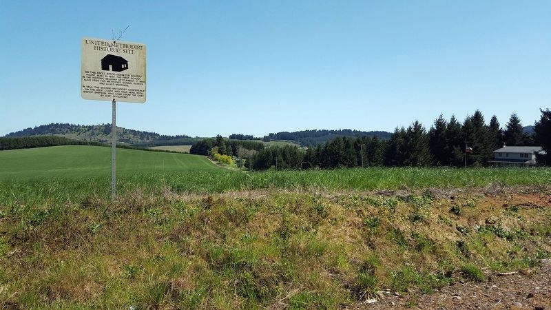
On this knoll stood Ebenezer School-
house, built in 1850. The first school
in the historic Belknap settlement, it was
also used for Methodist Sunday school
and class meetings.
In 1854, the second Methodist Conference
on the West . . . — — Map (db m119276) HM
(Two interpretive displays are located here next to the South Benton Community Museum):
(First Display)
In 1846, Jesse Applegate and fourteen others from near Dallas, Oregon, established a trail south from the Willamette Valley and . . . — — Map (db m116837) HM
United Methodist
Historic Site
No. 323
In memory of the pioneers of the Belknap Settlement who served God faithfully in an untamed land — — Map (db m122508) HM
This variable pitch water wheel was installed in the Long Tom River in 1906 to power the grain & flour machinery at the Adam Wilhelm Flour Mill. It also powered an electric generator that was later installed to provide electricity to the mill & the . . . — — Map (db m119283) HM
Philomath College was chartered November 1865, as the United Brethren School for Oregon, Washington, Idaho, Montana and California. The name combines two Greek words meaning love of learning. The building’s center structure was completed in . . . — — Map (db m122509) HM
On May 11, 1861 Reuben and Mary Jane
Holmes Shipley, former negro slaves,
deeded from their farm purchased from
Charles Bales’ donation land claim, the
original plot for this cemetery.
Buried in Lot 10 are Reuben Shipley, Mary
Jane Shipley . . . — — Map (db m118083) HM
During the first year of the Civil War, Reuben and Mary Jane Shipley donated land to establish this cemetery for the burial of both black and white people. The Shipleys were former enslaved laborers who arrived by wagon with their owners. Mary . . . — — Map (db m234519) HM
Mount Union Cemetery is situated on Reuben and Mary Jane Shipley, one of Oregon's earliest Black pioneer couples. Reuben was born into slavery in Kentucky and was brought to Oregon by his enslaver, Robert Shipley, in 1853. In return for driving . . . — — Map (db m234513) HM
In remembrance of
Harold E. Babcock
Eagle Scout, WW II Veteran,
Educator, and Master Mason
Mr. Babcock kept the flags
in Estacada flying for 20 years! — — Map (db m8745) HM
This mountain pass in named for Samuel K. Barlow who opened the first wagon route over the Cascades in 1846 to complete the Oregon Trail. The route was far from easy. Emigrant Isom Cranfill (cabinet maker, farmer, and itinerant preacher) made the . . . — — Map (db m112383) HM
Imagine feeding your hungry children and skinny ox teams whottleberries here. Helping you spouse repair your tired wagon for tomorrow's dreaded drop down Laurel Hill. Rain clouds gather around Mount Hood's peak. More storms coming. And they say the . . . — — Map (db m112373) HM
In 1924 engineers constructing the first Mt. Hood Highway discovered a gravesite here. The grave was marked with an old wooden wagon tongue buried beneath decades of overgrown brush. When they dug up the site, they found the remains of an emigrant . . . — — Map (db m113603) HM
First Road built over Cascade Range in 1845-1846 by
Samuel K. Barlow (1792-1867)
an Oregon Pioneer from Kentucky
Wamic -- Miles 32
Dalles California Highway -- Miles 38
Maupin -- Miles 48 — — Map (db m112396) HM
Village of
Government Camp
formerly a camp on the old Barlow Road, the village was named in 1849 when US Cavalry troops were forced to abandon wagons and supplies here. — — Map (db m112337) HM
Village of
Government Camp
Formerly a camp on the old Barlow Road was named in the fall of 1849 when the first United States Mounted Rifles abandoned a large number of wagons here, while a detachment was traveling from The Dalles to . . . — — Map (db m112338) HM
Samuel Kimbrough Barlow
Oregon Pioneer from Kentucky
Built the first wagon road across
Cascade Mountains
passing this spot
1845 - 1846
The building of railways . . . — — Map (db m241048) HM
dedicated September 28, 1937 by
Franklin D. Roosevelt
President of the United States
as a monument to the skill and faithful performance of workers on the rolls of the Works Progress Administration — — Map (db m112336) HM
In memory of the 304th Rescue Squadron aircrew members, who lost their lives on board aircraft King 56, while performing a training mission on the night of November 22, 1996. These men were Citizen Soldiers committed to the preservation of the . . . — — Map (db m11977) HM
George M. Rogers purchased this lot in 1918 and lived in its existing small house until 1929, when he engaged Van Evera Bailey, a noted Portland architect, to design this unique Arts and Crafts/Mediterranean style residence. Exterior is . . . — — Map (db m119859) HM
Henry Dodge Green and his brother John Green came to Oregon from New York in 1852. In partnership with H. C. Leonard, the Green brothers procured the gas and water franchises for the City of Portland. The cost of shipping cast-iron gas and water . . . — — Map (db m116109) HM
This cottage is the last survivor of cottages built for workers in Oswego's iron industry. It was probably built in the late 1870s or early 1880s by Albert Clinefelter or Lucien Davidson, local carpenters who constructed many buildings for the . . . — — Map (db m120039) HM
On this site in 1893, Oswego's first public school was built and served the children of the town until it was outgrown, and replaced in 1928 by this handsome Colonial Revival style structure. Originally called Oswego Grammar School, it was renamed . . . — — Map (db m116105) HM
"Charcoal haulers would cross the covered bridge and follow the trail along the river...."
Mary Goodall, Oregon's Iron Dream, (1958, p. 76)
At least four bridges have been built at the mouth of Oswego Creek and adjacent to Oswego . . . — — Map (db m116051) HM
This Arts and Crafts style building was constructed in 1940 as the Murphy Real Estate office. It is one of a cluster of buildings on State Street designed by the prominent local architect, Richard Sundeleaf. The half-timbered architecture was . . . — — Map (db m116518) HM
Albert Alonzo Durham filed the first donation land claim here in 1850, naming the place Oswego after his New York home town. In 1864 John Corse Trullinger bought Durham's sawmill on Sucker Creek, and in 1866 this 87-acre portion of land, Trullinger . . . — — Map (db m117168) HM
In the early 19th century, the river landing at the mouth of Oswego Creek was a convenient camping place for explorers, fur traders, and pioneers. In the words of one old timer, it was "a stopping place, a sort of a relay station for boats both . . . — — Map (db m121328) HM
This mass of solidified iron from the hearth of the Oswego furnace is known as a 'Salamander'. It is named after a mythological amphibian that lived in fire. Salamanders often formed in the bottom of 19th Century iron furnaces and were removed, with . . . — — Map (db m116143) HM
On this site Oswego's first industry, a saw mill, was established in 1850 by Albert Alonzo Durham on this portion of his 637 acre Donation Land Grant which included "Old Town" and much of East Oswego. He advertised his new mill in the . . . — — Map (db m117224) HM
In Prehistoric Times
Fifteen thousand years ago, the mouth of the Tualatin River was located at Like Oswego. The river's course changed when the cataclysmic Missoula floods poured down the Columbia Basin and inundated the Willamette Valley. . . . — — Map (db m120526) HM
Ikanum are traditional stories. One such story from Victoria Howard of Grand Ronde is told about the area around Lake Oswego. The story tells of a particularly hostile winter, in which cold and starvation threatened the entire village of . . . — — Map (db m116145) HM
Originally called Green Point, Indians gathered here for over 3,000 years to fish at Willamette Falls.
George Abernethy arrived here June 2, 1840, with the "Great Reinforcement" of Jason Lee's Willamette Mission. He took 640 acres just north . . . — — Map (db m286204) HM
"When woman's true history shall have been written, her part in the upbuilding of this nation will astound the world." -- Abigail Scott Duniway, Path Breaking (1914)
The third in a family of fourteen, Abigail "Jenny" Scott traveled west . . . — — Map (db m114173) HM
Commerce came quickly to the area as pioneers cleared land and became established. Pasture and grazing was common but presented transportation problems before refrigeration and good roads or bridges. The Clear Creek Creamery co-op was formed to . . . — — Map (db m114236) HM
Welcome to the Baker Cabin Historical Site. This is one panel of many that are spaced throughout the site. You are invited to see them all. The Baker Cabin Historical Society is the present day organization founded from the Old Timers Association of . . . — — Map (db m114257) HM
This marker is located on the grounds of Baker Cabin Historical Site.
Oregon Trail emigrants left established homes and farms in the East to start anew in the wilderness that was the Oregon Country. Emigrants packed simple farm wagons with enough . . . — — Map (db m114232) HM
The Baker's water supply consisted of a hand dug well located close to the cabin. Likely located by dowsing , there is a strong underground stream easily found even today with a 'water-witch.' The well extended down approximately 25 feet and often . . . — — Map (db m114256) HM
Before the coming of the white immigration, the flat area above the falls was a native encampment called "Kanim" or "Canoe Place". In 1844 Absolom Hedges staked out a donation land claim and platted it in 1849 naming the area Falls City. The first . . . — — Map (db m114029) HM
About four miles below Oregon City the Klackamass enters the Walhamettee: and, seated below the banks at its mouth, I saw a party of Indians of the Klackamass tribe, and I put ashore for the purpose of taking a sketch of them.
They were busy . . . — — Map (db m114759) HM
"Let us make a waterfall across the river." Meadowlark said to Coyote. So they made a rope by twisting young hazel shoots.
Holding one end of the rope, Meadowlark went on one side of the Willamette River; holding the other end, coyote went on the . . . — — Map (db m114060) HM
Coyote came to that place around Oregon City and found the people there very hungry. The river was full of salmon, but they had no way to spear them in the deep water. Coyote decided he would build a big waterfall, so that the salmon would come to . . . — — Map (db m114061) HM
Dr. Forbes Barclay left Scotland in 1839 for Fort Vancouver (Washington) where he became chief physician for Hudson's Bay Company. He moved to Oregon City in 1850 where he practiced medicine for many years. He was one of Oregon City's early mayors, . . . — — Map (db m8692) HM
Born in Riviere du Loup, Canada, October 19, 1784.
1824 Came to the Oregon Country as Chief Factor of the Columbia Department of the Hudson's Bay Company.
1829 Located his claim to the present site of Oregon City.
1845 Resigned his . . . — — Map (db m8699) HM
Chief Factor, 1821-1845, and Superintendent of the Columbia Department, 1824-1821, of the Hudson's Bay Company, laid claim to and took possession of the Site of Oregon City in 1829.
In 1842 he had the site surveyed, and subsequently dedicated . . . — — Map (db m114027) HM
"He stood among his pioneer contemporaries like towering old (Mount) Hood ... a born leader of men." -- Willard H Res, description of John McLoughlin during speech, 1879
His personality was measured in patience, generosity, . . . — — Map (db m114065) HM
It must have been long long ago that the earth shook. Then they would get their wooden pans and buckets, they would turn them upside down there, and they would sing and make a racket. They would say in their singing,
Put by the side of the . . . — — Map (db m114168) HM
Here the Pioneers Ended Their
Journey West.
Abernethy Green is the Official
End of the Oregon Trail,
As Designated by the U.S. Congress
In 1978.
Placed in Honor
of the Pioneer Achievements of
Dan Fowler
Oregon . . . — — Map (db m114198) HM
Oregon City, Western Terminus of the Oregon Trail
(about 2200 miles from Independence, MO)
Here at Abernethy Green in the fall of 1845, members of the Barlow-Palmer-Rector Wagon Train entered Oregon City as best they could. Pioneering a . . . — — Map (db m114199) HM
In memory of Eva Emery Dye and others who saved the McLoughlin House from demolition in 1909. The house was moved down Main Street and up Singer Hill to open as a museum on this location in 1910. Mrs. Dye was the author of “McLoughlin and Old . . . — — Map (db m8698) HM
Since time immemorial, Willamette Falls (Tumwater) has been an important fishing site for the Clowewalla (also known as the Willamette Tumwater) and Clackamas Chinook peoples. They controlled access to the falls through inter-tribal relationships . . . — — Map (db m114172) HM
"We pitched our tent... remaining at this camp for about one week, feasting on watermelons and good, fresh vegetables right from the garden, which are brought in by the Clackamas County farmers in great abundance." E.W. Conyers on arrival in . . . — — Map (db m114201) HM
George Abernethy who arrived at Willamette Falls in 1840 by ship, took a land claim that stretched from the Willamette River to Holcomb Hill. The neck of land that followed Abernethy Creek across Green Point became known as Abernethy Green. . . . — — Map (db m286194) HM
Native Americans are understood to have used this large rock for grinding acorns, nuts, or grains, and preparing other foods. The several holes are evidence of long term use. This rock may have been close to Native American encampments located near . . . — — Map (db m114255) HM
In 1864 Absolom Hedges donated 1.91 acres for a cemetery. By 1865 the Canemah Cemetery Association was formed and received a deed. In 1883 the Rhinehart family donated a 30 ft. wide roadway to 5th Avenue. In 1914 the cemetery was surveyed and iron . . . — — Map (db m114028) HM
The oldest brick commercial building remaining in downtown Oregon City
early tenants were J Myers & Co
"Cheap Cash Store" (1865-1888)
Clackamas County Courthouse (1865-1885)
Oregon City Enterprise (1880-1919)
the Bank of Oregon City . . . — — Map (db m288863) HM
Born in Washington Co. Va., Meek leaves home at age 18, arriving in St. Louis in the fall of 1828. Meek signs on as a trapper with the Rocky Mtn. Fur Co., remaining in the Rockies until 1839.
1839 - 1843: Meek travels to the Willamette Valley . . . — — Map (db m8673) HM
Born in Oregon City
June 10, 1949
Killed in Action
February 23, 1971
Vice President Ford of the United States of America awarded posthumously in the name of Congress
The Medal of Honor
for conspicuous gallantry & intrepidity in . . . — — Map (db m8711) HM
Lot Whitcomb, proprietor of the town, gave two lots and an unfinished building that had cost him about $1,000 - the first Episcopal church building in Oregon.
His wife, Irene, suffered from asthma. Believing Oregon a healthy place, in . . . — — Map (db m114171) HM
On this site was an early firehall. Current structure was built as City Hall housing city offices, Police Dept., and the jail, all of which remained until the mid 40s. Oregon City Beauty School occupied main floor and basement for 22 years. Jail . . . — — Map (db m8747) HM
In the city he founded, in this house he built, lived Dr. John McLoughlin, 1846-57.
He won enduring fame for his generous and humane aid to early American settlers in the Oregon Country, as Chief Factor and Superintendent of the Hudson’s Bay . . . — — Map (db m8693) HM
"A few of us (went) to the Falls of Willamut where we found many people & considerable of business." Medorem Crawford, Journal, October 3, 1842
An emigrant of 1842, Medorem Crawford worked for nearly a decade hauling freight around . . . — — Map (db m114760) HM
Built by Ed Johnson as a full service barber shop with 4 chairs and bathing facilities. Basement still has massive brick boiler for hot water originally fired by sawdust from local mill. Converted to restaurant in 1986. — — Map (db m8746) HM
"We claim that country - for what? To make the wilderness blossom as the rose, to establish laws, to increase, multiply, and subdue the earth..." -- John Quincy Adams, Congressional Globe, February 9, 1846
Arguing that God had manifestly . . . — — Map (db m114064) HM
Oregon City - supply point for pioneer emigrants was first located as a claim by Dr. John McLoughlin in 1829. The first provisional legislature of the Oregon Country was held here in 1843 and land and tax laws formulated. Oregon City was the . . . — — Map (db m8700) HM
Oregon City - once known as Willamette Falls - was early the site of an Indian salmon fishing village. The falls furnished the power for a lumber mill which began operation in 1842. A flour mill in 1844. A woolen mill in 1864 and the first paper . . . — — Map (db m113515) HM
Erected by the citizens of this pioneer Oregon community, this elevator tower replaces an original wood and steel structure, which was first advocated in 1899, and eventually constructed in 1913 on the west side of the railroad
tracks. The . . . — — Map (db m296934) HM
400 feet south
of this marker
stood the home of
Peter Skene Ogden
Chief Factor of
Hudson's Bay Co.
and rescuer of the
survivors of the
Whitman Massacre. — — Map (db m8714) HM
'It was two stories, 68 x 105, and was the first hotel west of the Rocky mountains." -- Harvey K. Hines, An Illustrated History... (1893)
In 1842 Dr. Elijah White recruited over one hundred people to emigrate across the Oregon Trail. . . . — — Map (db m114165) HM
Horace Baker emigrated from Illinois along the Oregon Traill in 1846 and married fellow emigrant Jane Hatten in 1852. The Bakers claimed 640 acres and built this cabin by 1856. The Baker Cabin is one of the oldest log structure in the state, and it . . . — — Map (db m114230) HM
Little is known about the first ten years after Horace and Jane Baker arrived in the 1846 Barlow Trail wagon train, and the construction of this cabin. Perhaps, like most pioneers they lived out of their wagon or tents the first winter. Most then . . . — — Map (db m114233) HM
The Barlow Trail branch of the Oregon Trail formally ended at the Phillip Foster Farm near Eagle Creek. From that point immigrants fanned out, taking several routes to Oregon City and beyond. One route passed this spot on the way up Gronlund Road to . . . — — Map (db m114235) HM
The Clowewalla (also known as the Willamette Tumwater) and Clackamas Chinooks were relocated to the Grand Ronde Reservation under the Treaty with the Kalapuya, Etc. 1855 (also known as the Willamette Valley Treaty).
The Clowewalla joined other . . . — — Map (db m114063) HM
When she went shortly after to her American woman friend, she told her, "They are going to take you Indian people somewhere pretty soon now." She told her, "Do not leave anything. Take along all your things with you. Put your canoe . . . — — Map (db m114762) HM
"Past on twelve miles or more, took the (w)rong road and arrived at the Willammette bottoms about dark a little below the City." -- Samuel Dexter Francis, October 14, 1852
In September and October, and early November the meadows at the . . . — — Map (db m114136) HM
In memory of all who gave their lives for the preservation of American Freedom
Spanish American War
World War I
World War II
Harold L. Adams •
Harold D. Alt •
Alfred W. Anderson •
Harold A. Anderson •
Robert C. Baker •
Herman v. . . . — — Map (db m13264) HM
Letters in newspapers, emigrant guide-books, and word of mouth gave counsel on overland travel. Emigrants commonly used farm wagons - simple, well-made, and utilitarian. Many were home-made or commission-built by local wagon makers. Some had custom . . . — — Map (db m114761) HM
When travelers arrived at the End of the Oregon Trail, they found Willamette Falls, a natural wonder that attracted both those early settlers and the Native Americans who settled here centuries earlier. For the traditional peoples, the main . . . — — Map (db m114034) HM
Willamette Falls is the second-largest waterfall by volume in North America. From time immemorial through today, it has been a gathering place for Native Americans. In the 1800s, it was the birthplace of the Oregon Territory and a center of . . . — — Map (db m269858) HM
Oregon City Mills, looking across the river to the newly built Willamette Falls Locks, 1874. Visible are the Imperial Flour Mills, built in 1863-1864, and to its right the Oregon Manufacturing Company (Oregon Woolen Mills) which was established . . . — — Map (db m286195) HM
In 1851, Dr. John McLoughlin dedicated a 7.8-acre park along the bluff now known as the McLoughlin Promenade for the use of the citizens of Oregon City. In 1938, a concrete pathway lined by stone walls and an adjoining grand staircase were . . . — — Map (db m269857) HM
The pioneer road here detoured the Columbia River rapids and Mount Hood to the Willamette Valley. The road at first followed an old Indian trail. The later name was Barlow Road. Travel was difficult. Wagons were snubbed to trees by ropes on held . . . — — Map (db m112372) HM
[Marker on Monument's front]:
In memory of veterans who served in all wars
"Never to be Forgotten"
Donated to the City of Sandy, Oregon
and dedicated on November 11, 1987 by members
of the Veterans of Foreign Wars of
the United . . . — — Map (db m8573) HM
In the shadow of the tall trees, a stream of travelers crossed ash flows, talus slopes and boggy wetlands along this last stretch of the trail. Some emigrants were forced to abandon their wagons with the death of livestock and walk, carrying their . . . — — Map (db m112341) HM
Chief factor of the Hudson’s Bay Company at Fort Vancouver, philanthropist, and founder of Oregon City. The land on the east bank of the Willamette River at the falls was claimed by Dr. McLoughlin and the Hudson’s Bay Co. in 1828-29. First called . . . — — Map (db m8669) HM
From 1845 to 1849, George Abernethy was the first Provisional Governor of the Oregon Country, which extended from the Pacific Ocean to the Rocky Mountains and from California to Northern British Columbia. After arriving in Oregon in 1840 as part of . . . — — Map (db m8670) HM
Was early the site of an Indian salmon fishing village. The falls furnished the power for a lumber mill which began operation in 1842, a flour mill in 1844, a woolen mill in 1864 and the first paper mill in the Pacific Northwest in 1867. The first . . . — — Map (db m113514) HM
Still in use below this point-were opened on New Years Day, 1873, when the steamer Maria Wilkins became the first vessel to navigate up the west end of Willamette Falls. Farming and shipping interests had long sought to eliminate expensive portages . . . — — Map (db m8667) HM
Many of Oregon’s early transportation routes resulted from the efforts of enterprising pioneers like the Boone family of Clackamas County. In 1846 Alphonso Boone, grandson of Daniel Boone, emigrated to Oregon via the Applegate Trail with his large . . . — — Map (db m127162) HM
Built in 1903, this building was important to area social life, serving as Wilsonville's first “community center.”
Meetings were held in a lodge hall that occupied the second floor. Area residents would also flock to the upstairs . . . — — Map (db m127203) HM
German immigrant farmers, attracted by the fertile fields of eastern Wilsonville, settled in this area and in 1878 founded Die Deutsche Evangelishe Reformierte Meridian Gemeinde des Clackamas County, Oregon, now the Meridian United Church . . . — — Map (db m231882) HM
The Grove of the States includes a tree representing each state in the USA and the District of Columbia. The idea for the Grove of the States was conceived by Oregon Attorney General Robert Y. Thornton to honor the passage of Lady Bird Jonson's 1965 . . . — — Map (db m127210) HM
Built at the turn of the 20th Century, the Norris Young Machine Shop served the farming community. Young, an accomplished machinist and inventor, repaired farm machinery and logging equipment.
Young was an enterprising businessman who along . . . — — Map (db m127204) HM
Built in 1905 and named for its colorful owner, Bill Flynn’s Saloon was a favorite hangout for residents and weary travelers. Farmers would park their wagons outside the saloon to rest their horses before the climb up “Whiskey Hill,” . . . — — Map (db m127205) HM
The Oregon Electric Railway was completed during the first decade of the 1900s, coming initially from Portland to Wilsonville, then on to Salem and Eugene after construction of a mile-long trestle across the Willamette River was completed in 1907. . . . — — Map (db m127219) HM
The Tauchman House overlooks the site of one of the Willamette River's first ferry operations, started in 1847 by Daniel Boone's grandson, Col. Alphonso Boone.
In the early days, the ferry boat transported passengers, wagons and livestock . . . — — Map (db m114278) HM
1428 entries matched your criteria. Entries 101 through 200 are listed above. ⊲ Previous 100 — Next 100 ⊳