Eaton County
Eaton County was organized in 1837 and named for President Andrew Jackson's war secretary, John H. Eaton. Pioneers had come to Bellevue, the first county seat, in 1833. The county was settled chiefly by New Englanders who . . . — — Map (db m121314) HM
This handsome brick church was completed in 1881. Seven persons organized the congregation in 1851 in nearby Carmel Township. Moving to Charlotte the next year, they held services in the wooden courthouse and in 1856 built the city's first place of . . . — — Map (db m121366) HM
Members of the Gresham United Methodist Church first worshipped in a school and in homes. In 1879 Palmer and Rebecca McDonald gave this site on which to build a church. In order to erect the church, people in the community donated logs, which were . . . — — Map (db m191522) HM
Local builder Nathan Johnson built this house around 1845 for Charlotte's first physician, Joseph P. Hall, and his wife, Mary. The house was moved from the business district to this site in 1868. Many professionals lived here, including . . . — — Map (db m126029) HM
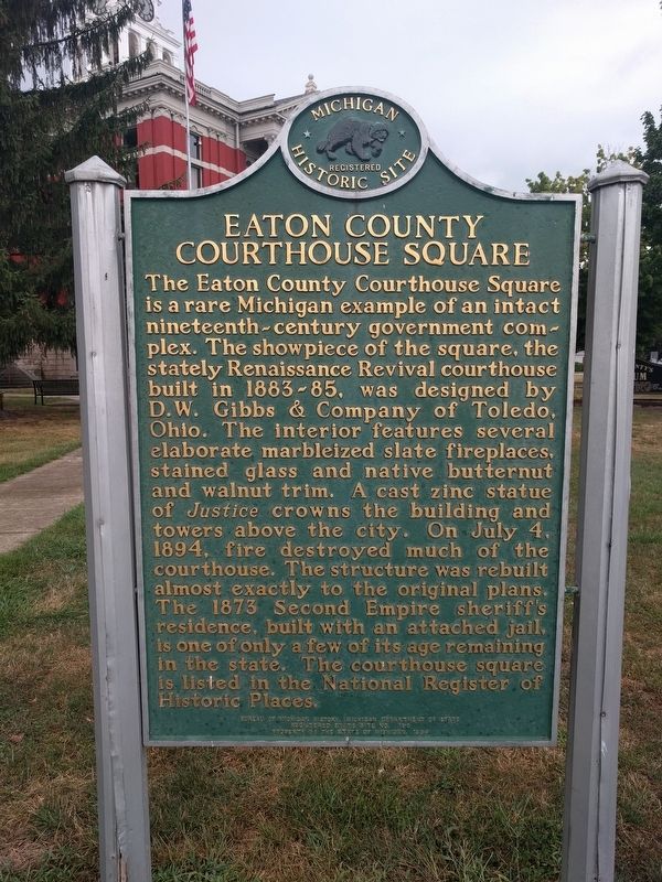
Side 1
Served for many years by circuit riding ministers, the Methodist congregation dates from 1838, making it Charlotte's oldest religious society. People worshipped at the home of Jonathan Searles, in a temporary courtroom in the Eagle . . . — — Map (db m121387) HM
Luren D. Dickinson
Michigan's thirty-seventh governor, Luren D. Dickinson (1859-1943), prided himself on being a frugal farmer. As a young man he taught school and served as principal of Potterville High School before becoming . . . — — Map (db m125995) HM
Eaton Rapids became a popular health resort when mineral water was discovered in 1869. Attracted by advertisements boasting of its curative powers, thousands came for treatment. The water was also bottled and shipped across the country. In 1874 . . . — — Map (db m171848) HM
Civil War governor Austin Blair (1818-1894) came to Jackson, Michigan, from New York in 1841. In 1842 he moved his law practice to Eaton Rapids. At that time the area was made up mostly of farmers, and Blair was paid for his legal services with . . . — — Map (db m171841) HM
In 1853 Warren and Sophia Ford deeded land for a school to Eaton Rapids School District No. 15. In 1869 the land became part of Hamlin Township. This one-room school, erected in 1884 with decorative Eastlake details, replaced one built in 1873. The . . . — — Map (db m171840) HM
This island, owned and operated by J. D. McAuliffe from 1872, was hailed as “a shady retreat for pleasure seekers...(with) a fine collection of animals and a museum of rare specimens”. In 1897 Eaton Rapids bought it for a city park. From . . . — — Map (db m171678) HM
In 1896 dairy farmers Dennis and Mary Miller produced ice cream for the first time on this site, using a hand-crank freezer. The 111-acre farm grew into a business with 14 farms, 1,300 acres, 500 Holstein cows, and modern equipment. In 1936 Miller . . . — — Map (db m171851) HM
The Eaton Rapids Reform Club, under the leadership of Isaac N. Reynolds, built this temperance hall in 1878. Affiliated with the national Red Ribbon movement, over a thousand local men knotted red ribbons in their lapels after pledging to abstain . . . — — Map (db m171843) HM
In 1923 the Veterans of Foreign Wars (VFW) initiated a plan to build a national home for the families of deceased and disabled American veterans. The following year a Jackson, Michigan, cattleman made his Ingham County ranch available for the site . . . — — Map (db m171836) HM
Constructed in 1884 as a roller skating rink, this building was purchased by Peter Blake and opened as Blake's Opera House in 1886. Here, audiences enjoyed talent shows, vaudeville, silent movies and athletic contests. Between 1928 and 1984, the . . . — — Map (db m122824) HM
Migrant Indian tribes led by the famous Chief Okemos called this area "Big Rocks." They came here in early spring to tap the sugar maples. Later, the beauty of the ledges and woods attracted the Grand Ledge Spiritualist Camp Association which, in . . . — — Map (db m122708) HM
Governor Frank D. Fitzgerald Home
Here lived Frank D. Fitzgerald who served his first term as governor 1935-36. His second term, starting in January 1939, was cut short by his death in this house in March of that year. Born in Grand Ledge . . . — — Map (db m122729) HM
Graced by the natural beauty of these soaring sandstone ledges, Grand Ledge was once famous for its Seven Islands Resort, a recreation area centered on this island from 1870 to 1910. At the turn of the century the ledges made this city one of the . . . — — Map (db m182468) HM
On this site in 1839, residents of Delta Township built their first school. A one-room woodframe structure, it could seat sixty-five. In 1940 the building was remodeled and a second classroom was added. Although the township district was annexed to . . . — — Map (db m182785) HM
Delta Township Musgrove Evans platted this area in 1827. The first settlers, Erastus and Sally Ingersoll and their twelve children, did not arrive until 1835. The township was organized in 1842. At the first township meeting, citizens chose . . . — — Map (db m182784) HM
The First Congregational Church grew out of the evangelical movement that swept the country during the early nineteenth century. The congregation and its anti-slavery and temperance societies were organized in 1845. Temperance activities continued . . . — — Map (db m216435) HM
On February 24, 1844, the Reverend John J. “Father” Shipherd and thirty-nine followers arrived by ox-cart on this wilderness hilltop, driving their herds before them. They felt God had directed them to this oak grove for the purpose of founding a . . . — — Map (db m216434) HM
Side 1
The Potterville United Methodist Church was organized after the Reverend Hiram Nichols held a revival meeting in Potterville in 1867. The congregation appointed a building committee in 1875 and began work on the church in the spring . . . — — Map (db m125966) HM
The Rev. Sylvester Cochrane, a Congregational minister from Vermont, first conceived of a settlement in Michigan after a visit here in 1835. Returning home he formed a group called the Union Colony, which settled in Vermontville the next year. The . . . — — Map (db m191516) HM
Vermontville Opera House, completed in 1898, is still the main center of community activities. The two-story red brick structure with cutstone foundation, and an off-center tower over the front entrance, was constructed with funds solicited from the . . . — — Map (db m191515) HM
In 1836 a group from Vermont known as the Union Colony settled here. The members were determined that their children should receive a good education. The Vermontville Academical Association was formed, constructed this building, and opened it for . . . — — Map (db m191517) HM
A Methodist class was organized in this area in 1845. Early worship services, held in private homes and local schools, were conducted by preachers traveling the Eaton circuit. In 1859 the Michigan Methodist Conference made Vermontville a separate . . . — — Map (db m191520) HM
Walter W. Fairbairn came to Alanson in 1888 as a government surveyor.
He worked as a blacksmith in Detroit and lived in North Dakota before settling permanently in Alanson in 1892.
Three years later, he established a hardware and plumbing . . . — — Map (db m107153) HM
Bay View
Bay View comprises one of Michigan's most spectacular collections of Victorian era architecture. Sweeping verandas and stately turrets characterize the Queen Anne style evident in the cottages and public buildings. Planned during . . . — — Map (db m97487) HM
J. W. Howard completed this spacious inn in 1887, naming it the Woodland Avenue House because of its proximity to that street. Later he called the hotel the Howard House. In 1923 the popular resort became the Roselawn in honor of Horace Rose, . . . — — Map (db m97565) HM
When the Terrace Inn opened in 1911, its owners billed it as Bay View's "newest and most modern hotel." One of only two remaining hotels among the resort's four hundred Victorian houses and public buildings, it was built to accommodate the growing . . . — — Map (db m97485) HM
The Legs Inn, named for the stove legs that trim the roofline, is one of Michigan's most exuberant and unusual landmarks. The building reflects Stanley Smolak's creativity and the craftsmanship of local Odawa (Ottawa) Indians. A Polish . . . — — Map (db m97844) HM
Andrew J. Blackbird House
Andrew J. Blackbird (c.1815 - 1908), an important figure in the history of the Odawa (Ottawa) tribe, was the son of a chief. Educated in the traditions of the Odawa, he also attended Euro-American . . . — — Map (db m97594) HM
The many-sided house across the street, sheathed in steel plates, was built for Ephraim Shay, inventor of the Shay locomotive. Patented in 1881, the locomotive operated by a gear-drive mechanism. Its great traction power and ability to operate on . . . — — Map (db m97600) HM
The Grand Rapids and Indiana Railroad linked Harbor Springs to its main line in 1882, further opening the Little Traverse Bay area to resort and commercial development. Grand Rapids architect Sidney J. Osgood designed this depot, built in 1889, . . . — — Map (db m97604) HM
This fort, built about 1715, put French soldiers at the Straits for the first time since 1701. French authority ceased in 1761 when the British troops entered the fort. On June 2, 1763, during Pontiac's uprising, Chippewa Indians seized the fort, . . . — — Map (db m7670) HM
Ezekiel Solomon, a native of Berlin, Germany, who had served with the British army, arrived at Michilimackinac in the summer of 1761.
He is Michigan’s first known resident of the Jewish faith.
Solomon was one of the most active Mackinac fur . . . — — Map (db m107159) HM
(Side A)
St. Ignatius of Loyola Church and Cemetery
By the 1740s, French Catholic missionaries had come to this area, known to the Odawa as Waganakising, to minister to local tribes. Later, missionary work was taken up by others, including . . . — — Map (db m97790) HM
During the late nineteenth and early twentieth centuries, city-dwellers from the Midwest escaped hot summers in the fresh air of northern Michigan. Constructed in 1899 for Norman J. Perry, the Hotel Perry catered to these vacationers with its . . . — — Map (db m97875) HM
For centuries this region has been the home of Ottawa Indians, whose warriors and orators fought bravely to retain their land. Around 1700 a mission was built by French Jesuits at the famous L'Arbre Croche villages which stretched from Cross . . . — — Map (db m55405) HM
In 1862 the Flint Pere Marquette Railroad built its original 26.1-mile section of track from Saginaw to Mount Morris. It selected Clio, originally known as Varna, as a railroad station location. The area around Varna was covered with white pine. The . . . — — Map (db m138086) HM
Constructed soon after the Detroit and Milwaukee Railroad reached town in 1855, this hotel has been a favorite resting and dining spot for over a century. It was said in 1883 that the guests were "entertained in a style unsurpassed in many large . . . — — Map (db m94761) HM
In March 1837 the Reverend Washington Jackson formed a Methodist congregation in Dibbleville (present-day Fenton) at the home of Levi Warren. Warren donated land and the first church was built in 1853. Its brick walls collapsed during the . . . — — Map (db m94759) HM
Many of Fenton’s early developers, politicians, businessmen, and veterans are interred in this cemetery, which was established in 1834. Clark Dibble, who made the first land purchase in present-day Fenton in 1834, and Dustin Cheney, who accompanied . . . — — Map (db m153632) HM
On May 3, 1858, the Reverend Henry Banwell held Fenton's first Episcopal service for the Ladies Mite Society. The society formally organized as Saint Jude's Episcopal Church on July 18, 1859. In 1860 members built their first church on this site, . . . — — Map (db m94716) HM
This mill, one of the last water-powered grist mills to operate in Michigan, was built in 1869. It was purchased by Tom Walker and John Browning for $10,000 in 1878. From then on the Walker family was involved with the mill for three generations. . . . — — Map (db m178068) HM
Side 1
In 1905 William Durant of the Buick Motor Company asked wheel and axle manufacturer Charles Stewart Mott (1875-1973) to build axles in Flint. The Mott family and business had moved from Utica, New York, to Flint by 1907. In 1913 . . . — — Map (db m142480) HM
Side 1
In 1905 William Durant of the Buick Motor Company asked wheel and axle manufacturer Charles Stewart Mott (1875-1973) to build axles in Flint. The Mott family and business had moved from Utica, New York, to Flint by 1907. In 1913 . . . — — Map (db m142532) HM
Berston Field House and Playground has served Flint citizens as an important recreation center since it opened in 1923. Designed by the Cambridge, Massachusetts, city planning firm of John Nolen, it was developed on land deeded to the city of Flint . . . — — Map (db m179964) HM
This Queen Anne style house, built circa 1890, was owned by automotive pioneer Charles W. Nash (1864-1948). Born in Illinois, Nash worked on area farms before forming a successful hay-processing firm, “Adams and Nash,” in 1882. He was hired by the . . . — — Map (db m179966) HM
In 1916, as a flood of new workers for Flint’s automobile factories caused housing shortages, the directors of the Flint Board of Commerce formed the Civic Building Association. The association had built 133 houses on 400 acres of farmland by . . . — — Map (db m180450) HM
The Community Presbyterian Church grew out of the Civic Park community, which General Motors established in 1919 through its Modern Housing Corporation to provide housing for its Flint workers. Several Presbyterian families in the area first met in . . . — — Map (db m180449) HM
In 1834 circuit rider Bradford Frazee held the first Methodist service in Flint. The following year, William Brockway, of the Saginaw Mission, established regular services in Wait Beach’s barroom. In 1836 the class of nine persons organized as the . . . — — Map (db m178345) HM
From its founding in 1864 through its closing in 1933 during the Great Depression, the First National Bank played a significant role in its home city´s development. The bank made loans and extended lines of credit to several fledgling motor . . . — — Map (db m178449) HM
Flint Industry From 1910 through the 1980s, automobile and parts manufacturing dominated Flint industry. Like the saw and flour mills that preceded them, the factories were centered west of downtown in the Flint River valley. Industry began . . . — — Map (db m180537) HM
Flint Road Cart Factory This one-story mill was built in the early 1880s as part of an unsuccessful effort to diversify the Flint Woolen Mills. In 1886 J. Dallas Dort and Billy Durant began leasing it to manufacture road carts. By the end of . . . — — Map (db m182343) HM
Genesee County was organized on March 8, 1836. The previous year the territorial legislature had stipulated that the county seat would be located on the west side of the Saginaw Turnpike “on lands recently deeded by John Todd and wife” . . . — — Map (db m121216) HM
Glenwood Cemetery was established in 1857. It is one of only a few mid-nineteenth-century Michigan cemeteries to feature a rolling landscape with winding roadways. The original cemetery, the western section of the present grounds, displays a broad . . . — — Map (db m178338) HM
Henry Howland Crapo Near this site stood the home of Henry Howland Crapo (1804-1869). Born in Massachusetts, Crapo in 1858 moved his family to Flint, where he had invested in timber land. Here, he developed a prosperous lumbering business, . . . — — Map (db m178409) HM
Jacob Smith The first permanent structure erected on this site was probably the trading post built in 1819 by Jacob Smith, the founder of Flint. Fluent in English, French, German and a half dozen Indian languages, Smith represented the Chippewa . . . — — Map (db m179846) HM
Dating from medieval times, Freemasonry is likely the world´s oldest fraternity. Freemasonry dates from 1848 in Flint. Completed in 1911, this building has housed lodges including Flint 23, Fellowship 490, Genesee 174, Charles A. Durand 533, . . . — — Map (db m178356) HM
Michigan School for the Deaf In 1848 the Michigan legislature established the Michigan Asylum for Educating the Deaf and Dumb and the Blind. Flint was selected as the site for the new institution. The first student arrived on February 6, 1854. . . . — — Map (db m178343) HM
Founded in 1875 and named in memory of Paul Quinn, the fourth bishop of the African Methodist Episcopal Church, Quinn Chapel is the oldest black congregation in Genesee County. This building, dedicated in 1957, is the congregation’s third house of . . . — — Map (db m180988) HM
Resisting Slavery During the mid-nineteenth century a small number of African Americans settled in Genesee County where they found cheap land and employment as barbers, laborers, farmers, carpenters, and domestics. At this time differing . . . — — Map (db m178352) HM
Sarah Emma Edmonds Sarah Emma Edmonds (1841-c. 1898) left her New Brunswick, Canada, home in 1858. Escaping what she feared would be a life of “enslavement” as a woman, she took on the identity of a man, Franklin Thompson, and found employment . . . — — Map (db m178353) HM
In 1834 Daniel O’Sullivan, a teacher from Ireland, moved to Flint and began teaching religion to students after school. Together with two traveling priests he convinced Bishop Leferve to build a church in Flint. That church became St. Michael Roman . . . — — Map (db m182515) HM
The Reverend Daniel Brown came to this area in 1839 to help form a new Episcopal parish. He became the first rector of St. Paul's in 1840 when it received canonical sanction. The congregation met in a temporary chapel and then in a small church . . . — — Map (db m121202) HM
Stockton House The November 9, 1872, edition of the Flint Wolverine Citizen newspaper reported the near completion of this house for retired army colonel Thomas Stockton and his wife, Maria. The newspaper called it "elegant" and "among . . . — — Map (db m178346) HM
On February 1, 1937, the wave of sit-down strikes against General Motors broadened as Chevrolet Plant No. 4 was seized. The United Auto Workers’ strategy was a diversionary strike at the nearby Plant No. 9 to draw company personnel to that point . . . — — Map (db m180550) HM
Starting December 30, 1936, this building was occupied for forty-four days by striking members of the United Auto Workers. The strikers, acting in concert with other plants that were closed or to be closed by sit-downs, asked for recognition of the . . . — — Map (db m178335) HM
Flint, platted in 1836, became known as the “Vehicle City.” The production of road carts reached 150,000 annually. Due to the foresight of its vehicle manufacturers Flint has become second only to the Detroit area in production of motor vehicles. A. . . . — — Map (db m178355) HM
Whaley House
The central portion of this handsome Victorian home was built in the late 1850s. Several prominent Flint families lived in it before Robert J. Whaley purchased it in 1884. Whaley a local lumberman and banker, remodeled the . . . — — Map (db m143776) HM
William C. Durant William Crapo Durant (1861-1947), one of Flint’s most important historical figures, was a pioneer in the development of the American auto industry. Durant’s vehicle ventures began in 1886, when, with a borrowed $1,500, he . . . — — Map (db m182338) HM
Amos Woodruff The Amos and Eliza Woodruff family migrated from Massachusetts to the Flushing area about 1845. During the next five years Woodruff purchased several parcels of land on River Road. In 1852 he acquired this land, which was part of . . . — — Map (db m180448) HM
This structure was completed and dedicated as the Brent Creek Methodist Protestant Church in the fall of 1891. There were sixteen members. The church, which was originally located slightly west of this site, was moved here in 1940. The . . . — — Map (db m180635) HM
In 1840, Flushing residents began holding religious services in James Seymour´s sawmill. In 1842 the First Methodist Episcopal Church was organized. As part of the Flint River Circuit, the Methodists were ministered to by circuit riders. In 1846, . . . — — Map (db m180633) HM
In 1835 Rufus and Sarah Harrison settled on this property, traveling by ox team from Detroit. It was said their farm was the first in Flushing Township to be cleared. Harrison died in 1856, and the farm was acquired by William Schram, his . . . — — Map (db m180632) HM
Village Of Gaines Between 1855 and 1858 the Detroit and Milwaukee Railway built a rail line from Detroit to Grand Haven. In 1856 Gaines Station was established as a rail stop and post office. In 1859 Henry Walker platted the town, aligning the . . . — — Map (db m178334) HM
In 1833 eleven people established the First Congregational Church of Grand Blanc. The congregation, which held its early services in homes and, later, schoolhouses built their first house of worship in 1855. They replaced it with this modest red . . . — — Map (db m179796) HM
At the close of the nineteenth century, many rural Michigan school districts were in crisis as people left farms for the city and industrial jobs. A 1903 state law authorized consolidation of districts and provided for public transportation to . . . — — Map (db m179803) HM
Simeon Perry Farmstead In 1826 Simeon Perry (1804-1880) came to this area with his father, Edmund, a cousin, Roland, and his sister, Eliza. They built a log house. Then Edmund and Eliza returned to Avon, New York, to bring the rest of the family . . . — — Map (db m179804) HM
The Buick Open
One year after Warwick Hills Golf and Country Club opened in 1957, Waldo McNaught used his unique position as club president and public relations director of the Buick Motor Division of the General Motors Corporation (GM) to . . . — — Map (db m135748) HM
In 1894, William Ray Perry built this house on the farm that was purchased by his father in 1829. The Queen Anne house displays Eastlake ornamentation. Perry’s forebearers had arrived in New England in 1650. In 1825 Edmund Perry, William’s . . . — — Map (db m179807) HM
Jonathan Davison (1795-1865), a native of Livingston County, New York, purchased 160 acres of land here in 1831. His son, John W. Davison, a farmer and carpenter, completed the rear portion of the present structure in 1855. He enlarged it to its . . . — — Map (db m179801) HM
As Americans settled the wilderness areas of Michigan, religious services were often the first community concern. Beginning in 1831, traveling preachers visited this area, holding revival and prayer meetings, and starting new congregations. One of . . . — — Map (db m179798) HM
In 1838, Halsey Whitehead, a veteran of the War of 1812, buried his two-year-old daughter Rebecca here on land he settled in 1837. He offered burial plots for others until 1843, when he donated the land to Argentine Township. Graves located here . . . — — Map (db m178234) HM
The Linden Mills were a vital source of this village’s economic growth. The first mill, located on the land granted to Consider Warner, was used to cut lumber. From 1845-50 Seth Sadler and Samuel W. Warren, local residents, erected both a saw and . . . — — Map (db m178181) HM
In 1891 the Reverend Daniel Webster Hammond and seven members chartered the Methodist Episcopal Church of Montrose. The next year a church was erected on this site; however, a growing congregation demanded a larger building. The present church was . . . — — Map (db m182293) HM
Montrose Township Cemetery
In 1859 Montrose Township bought three acres of land from John Berry to create a burying ground, which was later expanded. In August of that year, John Pickett Slade, a veteran of the War of 1812, was the first . . . — — Map (db m180510) HM
First United Methodist Church, one of the oldest congregations in Genesee County, began with services held in Lewis Buckingham’s home in 1836. The Reverend Luther D. Whitney, a Flint circuit rider, and nine other people, organized the congregation . . . — — Map (db m179823) HM
E. S. Swayze opened a drugstore on this site prior to 1870. When the store burned in 1874, Swayze built this one. Members of the Free Methodist Church used the second-floor meeting hall for services from 1887 to 1890. In 1903 Masonic Lodge #401 and . . . — — Map (db m182516) HM
This house was built in stages between the 1860s and the 1930s. In 1889 Dr. John B. Laing and his wife, Harriet, purchased the house. Raised in Vermont, Laing (1846-1908) came to Otisville in 1871 as one of the village's earliest physicians, and . . . — — Map (db m33731) HM
When Nathaniel and Sarah Smith came to the Forest area from Vermont in 1837, members of the Henry Hiester family were the only Euro-American settlers in the area. Sarah Smith died in 1848 and was the first person interred in the cemetery that bears . . . — — Map (db m179822) HM
At an altitude of more than 1500 feet, 300 feet above the surrounding terrain, this location was the southernmost area in Michigan to offer a prospect of producing copper in commercial amounts. The Chippewa Copper Mining Company began work here in . . . — — Map (db m45043) HM
The Gogebic was the last of the three great iron ore fields opened in the Upper Peninsula and northern Wisconsin. Beginning in 1848 with Dr. A. Randall, federal and state geologists had mapped the ore formations almost perfectly long before any ore . . . — — Map (db m45035) HM
Here lived Solomon S. Curry, pioneer in the mining industry of the Ironwood area. Curry, a progressive, broad-minded man, was also instrumental in the building of the city of Ironwood, which through his efforts, grew from a wilderness to one of the . . . — — Map (db m45047) HM
On this site, on October 8, 1871, geologist Raphael Pumpelly of Harvard University discovered one of the iron ore formations that created Gogebic County’s “boom era”. The Newport Mine, named for Pumpelly’s home in Rhode Island, began operations . . . — — Map (db m242372) HM
1551 entries matched your criteria. Entries 301 through 400 are listed above. ⊲ Previous 100 — Next 100 ⊳