One of the most visible and longstanding programs of the THC is the Historical Markers Program. This program, which began in the late 1940s, has erected nearly 2,000 markers commemorating sites, persons, and events significant in Tennessee history. ... The markers program is an effective means of introducing highway travelers to Tennessee history.
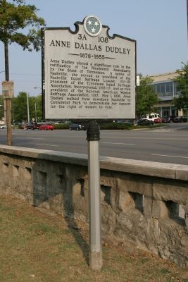
On West End Avenue (Tennessee Route 1) near 26th Ave, on the right when traveling south.
Anne Dudley played a significant role in the ratification of the Nineteenth Amendment by the State of Tennessee. A native of Nashville, she served as president of the Nashville Equal Suffrage League, 1911-15; president of the Tennessee Equal . . . — — Map (db m4524) HM
Near 27th Avenue North at Parthenon Avenue, on the right when traveling north. Reported missing.
The hill to the west was a strong point in the system of permanent Federal defenses, started in 1862, which extended to the river on both sides of the town. Artillery was emplaced here from time to time. — — Map (db m84792) HM
On Charlotte Avenue (State Highway 24) at 15th Avenue North, on the right when traveling east on Charlotte Avenue.
Formerly United Methodist Neighborhood Centers, Bethlehem Centers of Nashville began as settlement houses: Wesley House (1894), Centenary Center (1908), and Bethlehem Center (1911). Bethlehem Center was one of the first locations for African . . . — — Map (db m147461) HM
On West End Avenue (U.S. 70S), on the right when traveling south.
The house of John Cockrill, an early settler, stood about 60 yards north, near a large spring, whose waters ran northeast into Lick Branch, which emptied Great Salt Lick, around which Nashville was founded. A blacksmith shop stood under the great . . . — — Map (db m12765) HM
On 21st Avenue South at Medical Center Drive, on the right when traveling south on 21st Avenue South.
Near here, the interior defensive lines ran southwest to cross Harding Pike; the total length of these works was about 7 miles. First garrisoned by Wood's IV Corps, it was occupied Dec. 15 by Donaldson's Division of Quarter-master employees. Part of . . . — — Map (db m52145) HM
On 27th Avenue North at Parthenon Avenue, on the left when traveling north on 27th Avenue North.
The hill to the west was a strong point in the system of permanent Federal defenses, started in 1862, which extended to the river on both sides of town. Artillery was emplaced here from time to time. — — Map (db m61935) HM
On McMillin Street south of Charlotte Avenue (U.S. 70), on the right when traveling south.
This corner was part of the original prison ground for the first Tennessee State Penitentiary. The prison stood on 10 acres between Church Street and Cedar Street, now Charlotte Avenue, from 15th Avenue westward. The prison opened on January 1, . . . — — Map (db m151598) HM
On West End Avenue (U.S. 70S) east of Louise Avenue, on the right when traveling west.
A residence built on this site in 1910 served as the residence of the governors of Tennessee from 1921 until 1949, when a residence on Curtiswood Lane was acquired by the state. Governors who lived here were Alfred Taylor, Austin Peay, Henry Horton, . . . — — Map (db m52331) HM
On 21st Avenue, on the right when traveling north.
The Nashville Institute, renamed Roger Williams University, was located on a 28 acre campus next to Hillsboro Pike from 1874 to 1905. It was the largest of the Baptist schools for African-Americans, influencing many important educators and leaders. . . . — — Map (db m28417) HM
On West End Ave. (U.S. 70S) near the park entrance road.
Erected as the central structure of the Tennessee Centennial Exposition, 1897, this is the only full-scale reproduction of the fifth century B.C. Athenian temple and is exact in almost every detail to the original. The idea of reproducing the . . . — — Map (db m4152) HM
Vanderbilt Memorial Gymnasium was dedicated to Vanderbilt students and alumni killed in World War II on December 6, 1952. The site of civil rights activities; here in 1966 Nashville's Pearl High School won the first desegregated TSSAA basketball . . . — — Map (db m135220) HM
An independent, privately supported university founded 1873 by Commodore Cornelius Vanderbilt, New York shipping & railway magnate, who gave $1,000,000 to start the university & expressed his wish that it should "contribute to strengthening the ties . . . — — Map (db m25435) HM
Near here in 1820 the first Catholic Church in Tennessee was built by Irish Catholic workers then building a bridge over Cumberland River. In 1830 a brick structure known as Holy Rosary Cathedral succeeded the frame building. Here Bishop R. P. . . . — — Map (db m36240) HM
On 4th Avenue at U.S. 31/41/4, on the left when traveling south on 4th Avenue.
Morris Memorial Building. The Morris Memorial Building is named for the Rev. Elijah Camp Morris (1855-1922), who served as the first President of the National Baptist Convention, USA, Inc. from 1895 to 1922. At the time, the National Baptist . . . — — Map (db m174217) HM
On James Robertson Parkway (U.S. 431) just east of 2nd Avenue North, on the right when traveling west.
First hortelry on this spot was established by Maj. William T. Lewis, 1796. It became Winn's Inn in 1808, the Nashville Inn a few years later. Among its many distinguished guests were the three sons of the Duke of Orleans. Andrew Johnson, then . . . — — Map (db m147737) HM
On 4th Avenue North north of Harrison Street, on the left when traveling north. Reported permanently removed.
Nashville's first (1885) professional baseball was played in the Athletic Park which formerly occupied this block. Traditionally baseball was introduced in Nashville in 1862 by soldiers of the Union army of occupation who played the game here. This . . . — — Map (db m214005) HM
Designed by William Strickland, noted Philadelphia architect who also designed the tower of Independence Hall. Construction was commenced in 1845 and completed 1859. Strickland died in 1854 and is entombed in the north portico. His son Francis, . . . — — Map (db m36112) HM
On Dr. Martin Luther King Jr. Boulevard at 4th Avenue North, on the right when traveling west on Dr. Martin Luther King Jr. Boulevard.
Preceding the Civil War, this space, stretching from the intersection of 4th Avenue, North and Charlotte Avenue to the Public Square was the center of the slave trade in Nashville. The slave brokers that lined this thoroughfare provided prospective . . . — — Map (db m145783) HM
On Jefferson Street near 21st Ave N., on the right when traveling east.
(Obverse)
Citizens Savings Bank and Trust Company is the oldest, continuously operated African-American bank in the United States. Formerly known as the One-Cent Savings Bank and Trust Company and organized for the uplift of African . . . — — Map (db m81434) HM
On Doctor DB Todd Junior Boulevard at 17th Avenue North, on the right when traveling south on Doctor DB Todd Junior Boulevard.
Organized January 15, 1885, Nashville's first African-American fire unit, Engine Company No. 4, was located at 424 Woodland St. On January 2, 1892 Capt. C. C. Gowdy, hoseman Harvey Ewing, and reel driver Stokely Allen were killed while battling a . . . — — Map (db m151703) HM
On Dr. DB Todd Jr Boulevard at Knowles Street, on the right when traveling south on Dr. DB Todd Jr Boulevard.
In July 1932, the Rev. Wayman R. Horton organized the First Independent African Methodist Community Church. Instrumental in the Nashville Civil Rights Movement, the church's name was officially changed to First Community Church in 1966. The Rev. . . . — — Map (db m160112) HM
On Ed Temple Boulevard, on the right when traveling south.
Recognized as the first African-American professional golfer, Theodore "Ted" Rhodes, a native of Nashville, competed on the United Golf Association Tour. A predominately black tour, Rhodes won 150 tournaments from the late 1940s to 1960. Boxing . . . — — Map (db m4099) HM
Near 10th Avenue North at Rosa L. Parks Boulevard (Alternate U.S. 41).
Z. Alexander Looby, attorney, statewide civil rights leader, and a founder of the Kent College of Law, Nashville's first law school for blacks since the 1890s, is credited with desegregating the city's airport dining room and public golf courses. . . . — — Map (db m151705) HM
On 7th Avenue South just south of Drexel Street, on the left when traveling south.
In 1904, a Philadelphia nun and heiress, Mother Mary Katherine Drexel, purchased this site for Immaculate Mother Academy, which included a primary school and the first Catholic secondary school for black students in Tennessee. Holy Family Catholic . . . — — Map (db m147504) HM
On 9th Avenue South at McGavock Street, on the right when traveling north on 9th Avenue South.
Born here Jan. 1. 1858, a graduate of the Naval Academy in 1879, he commanded the USS Cushing in the War with Spain. In 1917 took command of the Cruiser and Transport Force, US Navy, which convoyed Allied troops to France without the loss of a man. . . . — — Map (db m147503) HM
On Rep. John Lewis Way South south of Peabody Street, on the right when traveling south.
Born 1803, in Salem, Massachusetts,
and a sea captain at 21, William
Driver retired in 1837. He came
here with his three children and
the flag given him by the girls of
Salem. He nicknamed the flag “Old
Glory”, the first known use of . . . — — Map (db m271985) HM
On Lea Avenue east of 5th Avenue South, on the left when traveling east.
Born in a house which stood here, Feb. 3, 1884, he graduated from the Military Academy
in 1905. Originally a cavalry officer, he transferred to the Air Corps in 1917. In 1941 he commanded the Caribbean Defense Command, later U.S. Air Forces, . . . — — Map (db m165435) HM WM
On Rep. John Lewis Way South (former 5th Street S.) south of Peabody Street, on the right when traveling south.
Born, 1803, in Salem Mass., and sea-captain at 21, he retired in 1837. Coming here for his wife's health, he brought with him the flag given him in 1832, which he had nicknamed "Old Glory," the first known use of the term. This flag was flown from . . . — — Map (db m74346) HM
On 4th Avenue South (Tennessee Route 11) at Oak Street, on the right when traveling south on 4th Avenue South.
First established in 1822, the remains of many early settlers were then brought here for permanent burial. Among the more than 20,000 persons buried here are Gen. James Robertson, Gov. William Carroll, Sec. of Treasury George W. Campbell, Lt. Gen. . . . — — Map (db m74357) HM WM
On Lebanon Pike (U.S. 70) 0.5 miles east of Fesslers Lane, on the right when traveling east.
After the War Between the States, the women of Nashville bought land at Mount Olivet, and formed Confederate Circle. The remains of about 1,500 Confederate soldiers were moved here from area battlefields. Seven Confederate generals were buried in . . . — — Map (db m76477) HM
On Elm Hill Pike at Spence Lane, on the right when traveling west on Elm Hill Pike.
George Woods was one of the earliest documented African-American archaeological technicians to work in Tennessee. He and his brother Joe were key participants during the 1877-1884 archaeological expeditions across Middle Tennessee sponsored
by . . . — — Map (db m147556) HM
On Elm Hill Pike at Spence Lane, on the right when traveling west on Elm Hill Pike.
At this location in 1905, Preston Taylor, a Nashville businessman, religious leader, and former slave, established the first park to serve Nashville's Negro community. Greenwood Recreational Park included a ball park, swimming pool, amusements, . . . — — Map (db m147553) HM
On Elm Hill Pike 0.2 miles east of Murfreesboro Pike (U.S. 41), on the left when traveling east.
Mount Ararat, Nashville's first African-American cemetery, was officially opened in April 1869. The property was purchased on March 23, 1869, by the Colored Sons of Relief Number One and the Colored Benevolent Society. Lots went on sale on May 2, . . . — — Map (db m151767) HM
On Fort Negley Boulevard 0.2 miles north of Chestnut Street, on the right when traveling north.
From October - December 1862, on this hill, black laborers helped the Union Army build Fort Negley. In November, blacks helped defend the unfinished fort against Confederate attack. During the Battle of Nashville (December 1864), nearly 13,000 black . . . — — Map (db m41483) HM
On Lester Avenue at Hart Street, on the right when traveling south on Lester Avenue.
Founded in 1865 as Central Tennessee College
for freedmen, the college was later named
Walden University and finally Walden College,
which stood on these grounds from 1922 to 1925.
While here, Walden College served as a normal
school for . . . — — Map (db m214000) HM
On Fourth Avenue South at Oak Street on Fourth Avenue South.
A native of Pennsylvania, William Carroll moved to Nashville in 1810. He became a successful merchant and hero of the War of 1812. William Carroll served longer as Governor, 12 years, than anyone else in the history of the state. Under his . . . — — Map (db m39407) HM
On Lafayette Street (Tennessee Route 1) at Claiborne Street, on the right when traveling north on Lafayette Street.
From a line of departure running NE-SW through here, Maj. Gen. Steedman’s Provisional Detachment of 6 brigades at 6:00 a.m. launched a holding attack southwestward against the Confederate right, on high ground about 2 miles south. The main attack, . . . — — Map (db m164104) HM
On Charlotte Avenue (U.S. 70) east of 33rd Avenue North, on the right when traveling west.
The right of the main Federal defense line crossed Charlotte Pike here. In the opening phase of the battle, mounted and dismounted cavalry of Wilson's Corps moved out of the Federal works, supporting the advance of Smith's XVÍ Corps in a turning . . . — — Map (db m163402) HM
On Brick Church Pike at West Trinity Lane (U.S. 431), on the right when traveling south on Brick Church Pike.
Thomas Talbot, Revolutionary War veteran wounded at the Battle of Kings Mountain,
South Carolina, served as sheriff of Washington County and Senate clerk for the State of
Franklin before moving to Nashville in 1789. On this site, he acquired 290 . . . — — Map (db m151762) HM
On West Trinity Lane (Tennessee Route 65) at Old Matthews Road, on the right when traveling east on West Trinity Lane.
Haynes School was named for William Haynes, a local African American who made the land available on which the school was built. With T. Clinton Derricks as founding principal, Haynes began in 1931 as an elementary school with grades one through . . . — — Map (db m154910) HM
On Broadway at 2nd Avenue North, on the right when traveling east on Broadway.
Sampson W. Keeble, barber, businessman, and civic leader, became the first African-American to serve in the Tennessee General Assembly. Serving from 1873 to 1875, Keeble was appointed to the House Military Affairs Committee and the Immigration . . . — — Map (db m24220) HM
On Delaware Avenue at 42nd Avenue North, on the right when traveling west on Delaware Avenue.
On July 6, 1891, the Tennessee Baptist Orphans' Home was established on this site. The orphanage was housed in the Hotel Delaware. With the encouragement of Mrs. Roger Eastman, the Tennessee Baptist Convention endorsed the home in 1894 as its . . . — — Map (db m151612) HM
On 17th Avenue North, on the right when traveling south.
(Obverse) Named for Joshua F. Pearl, the city's first superintendent of schools, Pearl was established in 1883 as a grammar school for Negroes and was located on old South Summer Street. It became a high school in 1897 when grades 9 thru 11 . . . — — Map (db m4988) HM
On Spruce Street at Pearl Street, on the right when traveling north on Spruce Street.
Spruce Street Baptist Church was originally a part of the First Colored Baptist Church, founded in 1848 as a "mission” of the First Baptist Church. Nashville's first black ordained minister, the Rev. Nelson G. Merry, served as pastor. In 1865, . . . — — Map (db m147459) HM
On Charlotte Avenue (U.S. 70) just east of 17th Avenue North, on the right when traveling west.
William Edmondson, a native Nashvillian and renowned primitive sculptor, worked exclusively in limestone. In 1937, he became the first African-American to be given a one-man show by the Museum of Modern Art in New York City. His visions in stone are . . . — — Map (db m151599) HM
On Harding Pike (U.S. 70S) west of Old Harding Pike, on the right when traveling west.
In 1883, Gen. William G. Harding gave his daughter, Mary, 2600 acres of his farm, Belle Meade. The same year, Mary and her husband, U. S. Senator Howell E. Jackson, bought a 131-acre farm adjoining that tract. They built this home at a cost of . . . — — Map (db m166469) HM
On Charlotte Avenue (U.S. 70) 0.2 miles east of White Bridge Pike ( Route 155), on the right when traveling east.
Forming the outer arc of the Federal main attack, R.W. Johnson's 6th Cavalry Division, Wilson's Corps, here hit Rucker's Confederate Cavalry Brigade, west of Richland Creek. Withdrawing south to Harding Road, Rucker held there until bypassing . . . — — Map (db m151694) HM
On Whites Creek Pike (U.S. 431) 0.1 miles south of Old Hickory Blvd., on the right when traveling north.
In this building, then a combination saloon and grocery, W.W. Earthman, magistrate and ex-constable of Davidson County, on March 25, 1881, arrested Bill Ryan, alias Tom Hill, ruthless and indiscreet member of the gang, members of which were living . . . — — Map (db m39211) HM
On Nolensville Pike at Forty-Four Parkway (Interstate 440), on the right when traveling north on Nolensville Pike.
Holding a line running NE and SW and with its right on the NC & St. L. R.R. at Rains Cut, Cheatham's Confederate Corps stood off the attacks of Steedman's brigades. Part of Cheatham's Corps was moved to the support of Stewart's life late in the . . . — — Map (db m164103) HM
On Hadley Avenue just south of 17th Street, on the left when traveling south.
Old Hickory Village was built on 5,600 acres in 1918, when the DuPont Company signed a contract with the Federal Government to operate and construct the world's largest smokeless powder plant. Mason and Hanger Construction Company built 3,876 . . . — — Map (db m149356) HM
On Tennessee Route 114 at Dunbar Road, on the left when traveling north on Tennessee Route 114.
(side 1)
Dunbar Store, originally called Hermitage, was the center of early settlement here. It served as a store, bar, stagecoach stop, and rest stop for travelers going west. After the Civil War, the bar was no longer profitable. The . . . — — Map (db m142747) HM
On East Main Street (Tennessee Route 100) at South Pleasant Street, on the right when traveling east on East Main Street.
13 miles southeast, this furnace was built, 1848. Iron was mined from nearby hematite deposits and processed here until 1876. The region is also known as “The Coalings”, because of extensive charcoal production here during iron mining . . . — — Map (db m63127) HM
On South Tennessee Avenue (Tennessee Route 69) at West Main Street (U.S. 412), on the right when traveling south on South Tennessee Avenue. Reported missing.
The "Pea Vine" A Ghost Railroad. In 1886, Tennessee Midland Railway Company was chartered to build a railroad from Memphis to Virginia. By 1889, 135.6 miles of track were completed to Perryville where it ended for lack of funds. In 1892, . . . — — Map (db m304665) HM
On State Highway 100 at milepost 14.5, 0.5 miles north of Perryville Road, on the right when traveling south.
In November 1821, the Tennessee General Assembly passed acts directing appointed commissioners to locate the county seat of the 1819-confirmed county of Perry. The appointees selected the community of Midtown to be laid off as a town called and . . . — — Map (db m150304) HM
On Nashville Highway (U.S. 70) 0.1 miles east of Hillwood Acres, on the right when traveling east.
North ½ mile, the first fair was held October 15-17, 1856, on the south bank of Hickman Creek. The buildings were destroyed by Federal troops in 1863 and rebuilt across the creek 9 years later. There, despite fire and flood, the fair has been . . . — — Map (db m150175) HM
On Nashville Highway (U.S. 70) at Foutch Road, on the right when traveling north on Nashville Highway.
The raid by Brig. Gen John H. Morgan's Cavalry Division into Indiana and Ohio began here. Units were the 2nd, 3rd, 5th, 6th, 8th, 9th, 10th, and 11th Kentucky Cavalry, and the 9th Tennessee Calvary, with attached artillery. Brig. Gen. Basil Duke and . . . — — Map (db m110553) HM
On Nashville Highway (U.S. 70) at Goose Creek Road, on the right when traveling east on Nashville Highway.
Wheeler School for Blacks was established during the Reconstruction period in Wilson County on land donated by Captain J.D. Wheeler, formerly of the 5th Tennessee Cavalry, C. S. A. Renowned Black educator W. E. B. DuBois taught at the school during . . . — — Map (db m150174) HM
On Nashville Highway (U.S. 70) at Old Dry Creek Road, on the right when traveling east on Nashville Highway.
On April 3, 1863, two Union brigades under Gen. Stanley advanced to this position to battle a Confederate Division commanded by Col. Gano of Morgan's Cavalry ½ mile east on Snow Hill. Union wounded were taken to the Williams house 300 yards to . . . — — Map (db m74306) WM
On Lancaster Road (State Highway 96/141), on the right when traveling west.
Center Hill Dam
Designed by the U.S. Army Corps of Engineers and built by private contractors, Center Hill Dam, 240 feet high and 2,160 feet long, impounds 64 miles of the Caney Fork River. Congress authorized the dam in 1938 to reduce flood . . . — — Map (db m157775) HM
On Nashville Highway (State Highway 70) 0.2 miles east of Dismal Road, on the right when traveling east.
The first settler (1797) in what later became DeKalb County, Dale built a water-powered log mill to grind corn for the settlers who followed him here in 1800. Traces of the dam remain on Smith's Fork, about 200 yards upstream. — — Map (db m224819) HM
On Tennessee Route 26 at Route 83, on the right when traveling east on Tennessee Route 26.
The Beckwith Inn was located just south of here on the Old Turnpike. Originally built by James Cannady in 1816, it was one of the best-known landmarks in DeKalb County. James B. and Rachel Roulstone Beckwith operated the inn from 1843 until the late . . . — — Map (db m84976) HM
On Tennessee Route 26 at Evins Mill Road, on the right when traveling east on Tennessee Route 26.
1/2 Mi. south on Fall Creek stood a watermill built in 1837 by Daniel Smith, an early Tennessee pioneer. The original mill was destroyed by flood in 1905, and a new one 1000 ft. distant was built by J.E. Evins near Carmack Falls, where the river . . . — — Map (db m84322) HM
On State Highway 96 east of Mathis Street, on the right when traveling east.
Built on the banks of Beaverdam Creek c. 1819-1820, “Lonesome” is a pioneer log cabin thought to be one of the oldest residences in Dickson County. It was built for William Austin (1790-1876), a veteran of the War of 1812, and his wife . . . — — Map (db m151413) HM
Replica of the home of Rev. Samuel McAdow where he, together with Rev. Finis Ewing and Rev. Samuel King, founded the Cumberland Presbyterian Church Feb. 4, 1810. Outgrowth of “The Great Revival of 1800,” the new denomination arose to . . . — — Map (db m151470) HM
On Promise Land Road 0.1 miles north of Reddon Crossing Road, on the left when traveling north.
In this locality shortly after the Civil War, freed slaves established Promise Land, the first African-American community of Dickson County. Early settlers were Nathan Bowen, Washington Vanleer, and two brothers, John and Arch Nesbitt. In time, the . . . — — Map (db m68961) HM
On Van Leer Highway (State Highway 49) 0.1 miles west of Fagen Chapel Road, on the right when traveling west.
The former home of this pioneer is 0.2 miles north. Here, March 18, 1804, the first County Court of Dickson County met with Lemuel Harvey presiding. Other members were Montgomery Bell, Richard Napier, Jesse Craft. William Doak, William Teas, Gabriel . . . — — Map (db m151438) HM
On Promise Land Road 0.1 miles north of Reddon Crossing Road, on the right when traveling north.
Born in the Promise Land community of Charlotte
Tennessee, Theodore and Lizzie Vanleer Edmondson
formed The Promise Land Singers who traveled
throughout Tennessee and Kentucky. In 1953, a
year before the beginning of the modern civil
rights . . . — — Map (db m274724) HM
On State Highway 48 0.1 miles south of New Dry Hollow Road, on the right when traveling north.
One mile west, James Robertson purchased land in 1793 to build the first iron works west of the Cumberlands. In 1804, Montgomery Bell bought it and during the War of 1812 supplied Gen. Jackson's army with cannon shot. From 1825 to 1863, A. W. . . . — — Map (db m151422) HM
On Frank Clement Place east of South Main Street, on the right when traveling east.
Born on this site, June 1920, Clement spent his childhood in Dickson. Famous as an orator, he was three times elected Governor of Tennessee, for a two-year term in 1952 and for four-year terms in 1954 and 1962. Among the programs inaugurated during . . . — — Map (db m68933) HM
On Cowan Road north of East Broad Street, on the right when traveling north.
In 1907 Thomas E. Miller established Miller Academy for Black students, which was the
forerunner of Hampton School. Miller served as the school's principal until 1919, when he moved to Illinois and the school closed. In 1922 the Dickson County . . . — — Map (db m151415) HM
On Center Avenue (State Highway 48) just west of West Walnut Street, on the right when traveling west.
In 1929, the Tennessee State Legislature authorized a memorial building to honor sons and daughters of Dickson County who served in World War I and other wars. A Colonial Revival style structure designed by architect E. H. Woolwine and built by . . . — — Map (db m158683) HM
On Jackson Hill Road (U.S. 70) just south of U.S. 70, on the right when traveling south.
1.1 miles southwest is a restoration of the log cabin in which Finis Ewing, Samuel King and Samuel McAdow organized the Cumberland Presbyterian Church on Feb 4, 1810. The congregation was made up of secedent members of the Presbyterian Church and . . . — — Map (db m143836) HM
On South Mill Avenue at West Court Street, on the left when traveling south on South Mill Avenue.
Col. Robert Henry Dyer served during the War of 1812, including the Creek War and as a commander on the left flank under Gen. Andrew Jackson during the Battle of New Orleans on Jan. 8, 1815. The previous night he was injured when his horse fell on . . . — — Map (db m255371) HM
Born in Ohio, he came to Dyersburg and practiced law before secession. In 1861 he raised here a company of the 4th Tenn. Infantry for the Confederacy. Winning successive promotion to the grade of brigadier general, he was killed leading his brigade . . . — — Map (db m63174) HM
On Old Highway 20 (Tennessee Route 210) at Bonicord Road Extension, on the right when traveling east on Old Highway 20.
About five miles southeast, in the family cemetery, is buried this veteran of the Revolutionary War. Born in Botetourt Co., Va., in 1763, he later moved to Guilford County, N.C., where he enlisted at the age of 18, serving under Generals Gates, . . . — — Map (db m56290) HM
On U.S. 412 at Bill Murray Road, on the right when traveling west on U.S. 412.
An important post-Civil War Black educator, Moody
was born to an enslaved man named Daniel and
Jane Freeman, a free woman of mixed race. He
farmed as a free man with his mother in Dyer
County; they hired his enslaved father as labor.
After . . . — — Map (db m255378) HM
On State Highway 59 0.1 miles east of Welch Road, on the right when traveling east.
In 1836, this church, sometimes called Palestine, stood in the thriving village of Concordia on the Randolph Road Stage Route about one mile west of Braden. Political speeches were made and voting took place here for Civil District 8. In the 1870s, . . . — — Map (db m148508) HM
On 3rd Street (State Highway 57), on the right when traveling west.
From here, Col. Benjamin H. Grierson's task force (6th Ill., 7th Ill., 2nd Ind. Cav., Btry "K", 1st Ill. Art.) raided into the deep south. Using as advanced guard Federals in Confederate uniform and other stratagems, he cut the Mobile & Ohio RR at . . . — — Map (db m19303) HM
On Third Street (State Highway 57) at Pine Street, on the left when traveling east on Third Street.
The "Queen of the Confederacy" was born here January 11, 1832. In 1858 she married Francis Pickens, United States Ambassador to Russia and later Governor of South Carolina. During the Civil War, Lucy was the only woman honored by having her portrait . . . — — Map (db m37274) HM
On 3rd Street (State Highway 57), on the right when traveling east.
This Protestant Episcopal Church was first established as a mission in 1832, consecrated in 1843. Rev. Samuel George Litton was its missionary and first rector. It was established by the efforts of Mrs. Mary Hayes Gloster a widow from Warrenton, . . . — — Map (db m62006) HM
On 3rd Street (State Highway 57), on the right when traveling east.
Settled in 1819 on the site of an Indian trading post, it was named for General La Fayette's ancestral home in France. He visited La Grange in 1824 and called it the "Beautiful Village." Its location on a bluff made it a natural military post; . . . — — Map (db m62007) HM
On 3rd Street (State Highway 57), on the right when traveling west.
This house was built in 1828 by Major Charles Michie, a veteran of the War of 1812. During the War between the States it was for a time headquarters for Maj. Gen. William Tecumseh Sherman of the Federal Army. It was also several times occupied by . . . — — Map (db m19299) HM
On Tennessee Route 59 0.2 miles south of Interstate 40, on the left when traveling south.
Named for Cypress Creek and at other times called Davis for the pioneer Davis family, ancestors of the Emerson family of Somerville, this church stood in the Center Point community on land owned now (1996) by James H. Shelton, great-great-grandson . . . — — Map (db m55399) HM
On Main Street (State Highway 57), on the right when traveling west.
Battle of Moscow December 4, 1863Three thousand Confederate cavalry with artillery, led by Gen. James Chalmers, attacked the Memphis & Charleston Railroad bridge over Wolf River and ambushed Col. Edward Hatch's brigade of Union cavalry crossing . . . — — Map (db m81524) HM
On State Highway 57 at Rossville Road (State Road 194), on the right when traveling west on State Highway 57.
Born in Rossville on January 12, 1904, Fred McDowell was one of America's eminent blues artists. His work, rooted in the Delta blues tradition, won him international fame. Of his unique bottleneck guitar style he said: "I make the guitar say what I . . . — — Map (db m19310) HM
On West Court Square 0 miles north of West Fayette Street (U.S. 64).
Fayette County was organized the first Monday in December, 1824, in the home of Robert G. Thornton, ten miles S. East on North fork of Wolf River. It was made a part of the district which David Crockett then represented in the state legislature. — — Map (db m33856) HM
On Alvin C York Hwy (U.S. 127) 0.5 miles south of Clarkrange Monterey Hwy/Deer Lodge Hwy (State Route 62), on the left when traveling south.
Kate Bradford Stockton was born in Stockton, California, in 1880. Four years later, she moved with her parents to Fentress County. She was the descendant of a distinguished family of radical thinkers, and was the product of the Upper Cumberland . . . — — Map (db m72466) HM
On U.S. 127 at Election Road, on the right when traveling north on U.S. 127.
Fentress County Established 1823; named in honor of James Fentress then speaker of the State House of Representatives, an office which he had held for four terms.
Pickett County Established 1879; named in honor of Howell L. Pickett . . . — — Map (db m98858) HM
On North Main Street (U.S. 127) south of Dragon Drive, on the right when traveling south.
Born in nearby Pall Mall, 1887. Enlisted in U.S. Army 1917, all-American Division, and became outstanding hero of World War I. Awarded Congressional Medal of Honor and Croix De Gurerre for killing 25 of the enemy and single-handedly capturing 132. . . . — — Map (db m62907) HM
This cemetery was established in the early 1800’s and was originally called Mt. Pleasant Burying Ground. The oldest known grave of approximately 600 burials is Charles Paul, 1826. Wolf River’s first settler, Conrad “Coonrod” Pile, is . . . — — Map (db m62905) HM
On U.S. 64 0.2 miles west of Walnut Grove Road, on the right when traveling west. Reported missing.
The homestead which David Crockett occupied and named in 1812 is now marked by a well standing in a field 3-1/2 miles south and to the east of this road. From here he went to the Creek War; his first wife died here. In 1816 he married Elizabeth . . . — — Map (db m284055) HM
Lived here. He came to Franklin Co. in 1872 from Ohio. In 1892, with the aid of J. B. Killebrew, agricultural agent of the N. C. & St. L. RR. and former State Commissioner of Agriculture, he imported from France the first crimson clover seed, . . . — — Map (db m26828) HM
On U.S. 64 close to Maxwell Road, on the right when traveling west.
David Crockett, his first wife and their children settled on a homestead a few miles east about 1813. She died in 1815, following her husband's return from the Creek War. She is buried in an old cemetery overlooking Bean's Creek, about five miles . . . — — Map (db m26172) HM
On Cumberland Street West (U.S. 41A) at Front Street South, on the right when traveling south on Cumberland Street West.
Built in 1904, the Cowan Railroad Depot handled travelers bound for Nashville and Chattanooga, as well as Sewanee and the Cumberland Plateau, until it closed in 1971. In 1976 the depot was moved from Tennessee Avenue to its present location, now . . . — — Map (db m58253) HM
On South Main Street (Tennessee Route 41-a), on the right when traveling north.
Here was one of the earlier training camps of the Confederacy. Units training here included the 1st Tenn. Infantry (Maney) and 17th Tenn. Infantry (Newman). The area, covering the former mill settlement of Allisonia, was heavily fortified to protect . . . — — Map (db m81537) HM
On Banks Street (State Highway 97) at Alabama Street (State Highway 97), on the right when traveling east on Banks Street.
Hunter's Grocery's new brick building was constructed in 1918, by J.H. Hunter, after his old wood frame store and a large part of the town of Huntland was destroyed by fire on Aug, 9, 1917. The store provided grocery items not only for Huntland . . . — — Map (db m152117) HM
On Route 64 at Old Salem Lexie Rd, on the right when traveling west on Route 64. Reported missing.
1.2 miles north. In 1810, this was a leading cotton-producing region. The brick building, built around 1825, housed a thread mill, which utilized the water power of Bean's Creek. It operated sporadically until about 1890. — — Map (db m284056) HM
On U.S. 64 at Old Salem Lexie Road, on the right when traveling west on U.S. 64.
The first permanent settler in what later became Franklin Co., he established a forge and gunsmith shop in a cave on Caney Hollow Branch, about three miles north, shortly after 1800. A gunsmith of great ability, his 45-inch long rifles became famous . . . — — Map (db m31561) HM
On Tennessee Route 64, on the right when traveling east.
Here, and extending 2 miles S.W., occurred the last battle of the Middle Tennessee Campaign. Protecting Bragg's withdrawal, Maj. Gen. Joseph Wheeler, with Texas Rangers and the 4th Tenn. Cav., repulsed an attack by the 5th & 6th Ky. Cav., under Col. . . . — — Map (db m24192) HM
On University Avenue 0.1 miles north of Reed's Lane, on the right when traveling south.
Nine years after Brown v. Board of Education, eight local families initiated a lawsuit to compel Franklin County to desegregate the public school system. The plaintiffs included the Bates, Cameron, Camp, Goodstein, Hill, Sisk, Staten, and . . . — — Map (db m153772) HM
1484 entries matched your criteria. Entries 301 through 400 are listed above. ⊲ Previous 100 — Next 100 ⊳