On 3rd Street East just east of Sims Street, on the left when traveling east.
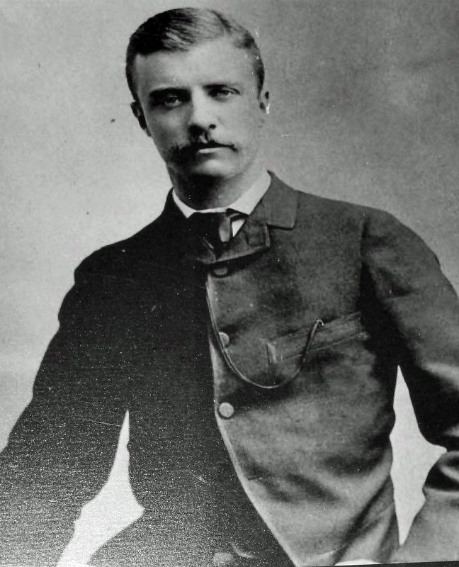
In July of 1886, a young Theodore Roosevelt gave his first major public speech right here in Dickinson, North Dakota. Roosevelt had been asked to give the Independence Day speech by Dr. Victor Stickney, the man who had patched up Roosevelt's feet . . . — — Map (db m238083) HM
Near East Burdick Expressway (Business U.S. 2) at 13th Street Southeast, on the right when traveling west.
Medal of Honor Citation Lt. Col. Roosevelt distinguished himself by acts of bravery on July 1, 1898 near Santiago de Cuba, Republic of Cuba, while leading a charge, accompanied by only four or five men up San Juan Hill. This action encouraged . . . — — Map (db m231684) HM
Susan Brownell Anthony
Woman Suffrage Leader
Visited October 19, 1878
"To secure both national and 'domestic tranquility,' to 'establish justice,' to carry out the spirit of our Constitution, put into the hands of all women....the . . . — — Map (db m53838) HM
On Belmont Street 0.1 miles north of 34th Street, on the right when traveling south.
Side 1
Union Square and Its Uses
Labeled "Union Square" on the first village maps, block 12 of the City of Bellaire was formed by joining portions of the Harris and Rodefer Farms in 1857. Used for tent shows, circuses, political . . . — — Map (db m78494) HM
On East Mansfield Street (U.S. 30) at Penn Avenue, on the right when traveling west on East Mansfield Street.
This monument, erected by lodge members and friends, is affectionately dedicated
to the memory of John Edward Hopley, 1850 - 1927, pioneer in Lincoln Highway development. First state consul for Ohio of the Lincoln Highway Association. In 1887 he . . . — — Map (db m135375) HM
On Detroit Road (Ohio Route 254) just west of Walden Drive, on the right when traveling west.
Theodore Elijah Burton
Born in Jefferson, Ohio, Theodore E. Burton graduated from Oberlin
College and became a prominent Cleveland attorney. He was elected
to Congress in 1888 and served from 1889-91, 1895-1909, and
1921-28. He was . . . — — Map (db m267580) HM
University Hall was completed in 1893. It is constructed of Amherst Sandstone. The bell tower rises to a height of 148 feet. The structure houses administrative offices, classrooms, and the legendary Gray Chapel. Among the celebrities who have . . . — — Map (db m12845) HM
Near High Street south of Broad Street (U.S. 40), on the right.
This tree (a Scarlett Oak) was placed here by the Roosevelt National Living Memorial Association, as a living tribute to the great lover and defender of Country and Flag, and our youngest President of the United States—Theodore Roosevelt.
. . . — — Map (db m9866) HM
On Auburn Avenue, on the left when traveling south.
William Howard Taft. Born here on September 15, 1857, William Howard Taft is the only American to have served as President and Chief Justice of the United States. His unique career of public service began after he graduated from Yale . . . — — Map (db m168978) HM
On Bainbridge Road at Avon-Beldon Road ( Route 83), on the right when traveling east on Bainbridge Road.
US Service Members: 16,112,566
Battle Deaths: 291,557
We stand in the presence of
the honored dead. We stand
accountable to them, and to
the generations yet unborn
for whom they gave their
lives. God, the father of all
living, . . . — — Map (db m300420) WM
Piqua's public square, like in many mid-western communities, functions as the historical and cultural center of the city. Long after government buildings have moved to newer and larger sites, the public square maintains its status as the focal . . . — — Map (db m17367) HM
Near Route 125 0.7 miles north of Mackletree Road, on the left when traveling north.
In the early 20th century Ohio’s deer, wild turkey, beaver, bobcat, and other wildlife populations were facing extinction due to the widespread loss of forests combined with uncontrolled hunting. Ohio’s first wildlife area, The Theodore Roosevelt . . . — — Map (db m225778) HM
On Main Street (Ohio Route 29/47), on the left when traveling north.
Theodore Roosevelt
Former President Theodore Roosevelt addressed a large crowd from these steps on May 16, 1912. He was introduced by C. B. De Weese.
William Howard Taft
President William Howard Taft was the first sitting . . . — — Map (db m28619) HM
On Main Street (County Route 57) at Cross Street (County Route 55), on the right when traveling west on Main Street.
Vice President Charles Warren Fairbanks
Charles Warren Fairbanks became a
prominent lawyer and nationally known
political leader. He was the keynote
speaker at the Republican Convention in
1896, United States Senator from 1897 . . . — — Map (db m87103) HM
On Front Street, on the right when traveling south.
President Theodore Roosevelt and W. H. Taft spoke here in 1912. President Franklin Roosevelt dedicated the “Start Westward” sesquicentennial monument in 1938. — — Map (db m20603) HM
On West Grand Avenue (Business U.S. 60) just west of South 1st Street, on the left when traveling west.
Arcade Hotel The Arcade Hotel began as a small wood frame structure. The hotel building, a so-called "house of ill-repute", was moved to Ponca City in 1897 from the city of Cross after Ponca City received a stop on the Santa Fe Railroad. Cross . . . — — Map (db m263799) HM
In the summer of 1909 the Abernathy brothers set off alone on horseback, riding from their Cross Roads Ranch in Tillman County to Santa Fe, New Mexico and back. Louie (Bud) was nine years old. Temple was only five.
On April 5, 1919, with Bud and . . . — — Map (db m120036) HM
On East 1st Street (U.S. 70) at Main Street, on the left when traveling west on East 1st Street.
When Kiowa-Comanche-Apache lands in Oklahoma opened to white settlement 1901, there were 505,000 acres reserved as grazing lands. This area became known as Big Pasture. Most of region leased for cattle ranching. Because of soil’s fertility, white . . . — — Map (db m282381) HM
On State Highway 5 0.1 miles west of N 2330 Road, on the right when traveling east.
President Theodore Roosevelt arrived by train, in Frederick, Oklahoma, on April 5, 1905. The President came to join famed wolf hunter, Jack “Catch ‘em Alive” Abernathy, on a wolf hunting expedition. More than 5,000 excited citizens . . . — — Map (db m108858) HM
On Oklahoma Route 5 south of County Road E1770, on the right when traveling north.
On April 5, 1910, 9 year old Bud and 5 year old Temple Abernathy, left the Crossroads Ranch near Frederick, Oklahoma, and traveled alone on horseback to New York City. Their father, Jack Abernathy, a close friend of President Theodore Roosevelt, . . . — — Map (db m120033) HM
On Fish Lake Rd at Park Meadows Rd, on the right when traveling west on Fish Lake Rd.
Early-day explorers, settlers, and rangers named some the the places in the forest. "Whiskey Spring" apparently received its name as part of an "alcoholic" theme, along with "Rye Spring" and "Bourbon Spring" to the south. Also a few miles to the . . . — — Map (db m112878) HM
On Upper Applegate Rd, on the right when traveling north.
This simple frame building — listed on the National Register of Historic Places - is one of the oldest Forest Service structures in the country. Known for many years as the “tack room,” it has served a variety of purposes since its . . . — — Map (db m113409) HM
Early industries in the Florence area were built on the natural resources that the Siuslaw River Valley had to offer. The rivers were filled with swarming salmon and the forests held acres of old growth timber. Those abundant natural resources . . . — — Map (db m93894) HM
Near South Water Street (Route 550) south of West High Street, on the right when traveling south.
Welcome to the Lumber Heritage Region of Pennsylvania, a celebration of our history, our people, and our forest. From the onset of early exploration and settlement, when the region was blanketed in virgin timber, to the days when streams and . . . — — Map (db m134712) HM
This statue is a replica of a bronze sculpture of Dickenson College founder Dr. Benjamin Rush that stands of the grounds of the U.S. Navy Bureau of Medicine and Surgery in Washington, D.C. The original statue by Roland Hinton Perry was a gift to . . . — — Map (db m152379) HM
Began April 25, 1898 when Congress declared war against Spain
Ended December 10, 1898 with the Treaty of Paris
Total Service Member - 306,760
Total casualties killed, died, or wounded worldwide - 4,108
[Historical images include] . . . — — Map (db m304732) WM
Notably the Congressional Medal of Honor is awarded to a small percentage of remarkable individuals.
The only President to have been awarded the Medal of Honor was
Theodore Roosevelt, who was awarded, posthumously, for his actions in
the . . . — — Map (db m304734) HM
On State Street at Third Street, on the left when traveling east on State Street.
Upon the destruction of the Old Capitol Building in 1897, the sense of loss was quickly replaced by a new spirit of community advancement for which the construction of a new Capitol Building would act as catalyst. In order to continue the operations . . . — — Map (db m154747) HM
On Smithbridge Road east of Bob Mench Drive, on the left when traveling east.
SPANISH-AMERICAN WAR
(1898) Aiming to secure independence for Cuba and the Philippines, the US declared war on Spain in April 1898. Hostilities erupted after the USS Maine was sunk in Havana Harbor, giving rise to the battle cry . . . — — Map (db m232029) WM
On 2nd Street (U.S. 522) at Market Street, on the right when traveling south on 2nd Street.
[Dedication Plaque]:This park forum and bronze tablets erected by the citizens of Fulton County as a memorial to her soldiers who served in the Civil War, the Spanish-American War, and the World War.
1861 • 1865
[Top of Civil . . . — — Map (db m251480) WM
On Adams Avenue 0.1 miles north of Spruce Street, on the left when traveling north.
In May 1902, 150,000 mineworkers struck for six months for union recognition, higher wages, shorter hours, and other demands. The Anthracite Coal Strike Commission, set up by President Theodore Roosevelt, held hearings at the Lackawanna County . . . — — Map (db m67827) HM
On South River Street near South Street, on the right when traveling south.
From headquarters in Wilkes-Barre, Howe's six touring shows introduced motion pictures to rural Americans. Pioneer exhibitor of "high class" film programs with coordinated sound. Filmed world & local events, including Pres. Theodore Roosevelt's . . . — — Map (db m18599) HM
On Penn Street, on the right when traveling north.
Founding pastor of Holy Savior Parish in 1895. Known as the Labor Priest, he championed the workers' cause and was instrumental in settling the Anthracite Strike of 1902. He was a friend of Theodore Roosevelt, who visited here often. — — Map (db m19059) HM
On South Main Street just north of West Northampton Street, on the right when traveling south.
16 blocks of the Connecticut settlers
Teedyuscung King of the Delawares •
Francis Slocum Kidnapped Indian princess •
John Wilkes English friend of the States •
Isaac Barre French . . . — — Map (db m252026) HM
On Packer Street, on the right when traveling north.
Founded in Williamsport in 1831 and named for its honored director Daniel Repasz, it is one of the oldest American community bands. The band played at Lee's surrender at Appomattox in 1865 and at its 150th anniversary in 2015, and at Grant's Tomb . . . — — Map (db m145870) HM
On Walnut Street (County Road 3006) near South Watts Street, on the right when traveling west. Reported permanently removed.
Until 1903, "The Yellow Mansion," pictured here, stood at the northeast corner of Broad and Walnut streets (directly behind where you are standing). Build in 1839 for a wealthy banker, it was for a time the most valuable home in the city. . . . — — Map (db m191882) HM
Near South Christopher Columbus Boulevard at Spruce Street, on the right when traveling north.
Theodore Roosevelt had a great love for naval history and strategy and his career as a politician and statesman intertwined with Olympia several times.
Roosevelt visited Olympia twice in his career as a politician. The first . . . — — Map (db m290115) HM
Near South Christopher Columbus Boulevard south of Spruce Street, on the right when traveling north. Reported permanently removed.
Olympia
Cruiser Olympia, launched in 1892, is the oldest steel warship afloat today. Olympia is best known as Commodore George Dewey’s flagship in the Battle of Manila Bay, Philippine Islands during the 1898 Spanish . . . — — Map (db m19242) HM
On Walnut Street at South 16th Street, on the right when traveling west on Walnut Street. Reported damaged.
This stately Renaissance-style home at the Northwest corner of 16th & Walnut Streets was built in 1901 for a wealthy banker and designed by renowned Philadelphia architect Horace Trumbauer, who also designed the Philadelphia Museum of Art. This . . . — — Map (db m191880) HM
On Market Street (County Road 2004) at South 6th Street, on the right when traveling east on Market Street.
This intersection of Market Street and Sixth Street has always been bustling with energy and traffic. This image from 1902 of southeastern corner looking east shows the variety of forms of transportation used at that time, including horse-drawn . . . — — Map (db m227589) HM
On East Centre Street at North Union Street, on the right when traveling east on East Centre Street.
In May 1902, 150,000 mineworkers struck for six months for higher wages, union recognition, shorter hours, and other demands. A July 30th riot of 5,000 strikers in Shenandoah led to its occupation by the PA National Guard and influenced President . . . — — Map (db m67358) HM
Near Main Street (Pennsylvania Route 660) 0.1 miles west of Central Avenue ( Route 287).
This testimonial is dedicated by the North American survivors, colleagues of E.A. VanValkenburg during the quarter-century in which he directed the publication of the Philadelphia North American. As its editor he inspired and directed public opinion . . . — — Map (db m88334) HM
On Avenida de la Constitución/Constitution Avenue (State Highway 25/26) west of C.Reverendo Gerardo Dávila/Rev. Gerardo Dávila St., on the right when traveling east.
Prior to being sworn in, President Roosevelt had already served as vice president, governor of New York, assistant secretary of the navy and president of the Board of Police Commissioners of the City of New York. President Roosevelt's . . . — — Map (db m193243) HM
Mary Ferrazzoli (1928-1994) was the visionary leader who founded the Friends of the Waterfront in 1982. She vigorously championed public access and stood firmly opposed to the commercial overdevelopment of the Newport waterfront blocking public . . . — — Map (db m189622) HM
On Freedom Blvd. (US 21) at Freedom Rd. (US 21), on the right when traveling north on Freedom Blvd. (US 21).
The first settlement of the town of Branchville was 1735 about one mile southeast of the present town. Almost 100 years later, the present town grew from 170 acres of land purchased from the South Carolina Canal and Railroad Company. It was . . . — — Map (db m16536) HM
From hunting club to Refuge
What was once a hunting camp is now a refuge for waterfowl and other migratory birds. Waubay National Wildlife Refuge (NWR) was established in 1935 by President Franklin D. Roosevelt in response to record low . . . — — Map (db m125350) HM
From hunting club to Refuge
What was once a hunting camp is now a refuge for waterfowl and other migratory birds. Waubay National Wildlife Refuge (NWR) was established in 1935 by President Franklin D. Roosevelt in response to record low . . . — — Map (db m125355) HM
On 2nd Avenue (South Dakota Route 471) north of G Street, on the right when traveling north.
(Side 1)
President Theodore Roosevelt (T. R.) stopped in Edgemont on April 25, 1903 as part of a
western states tour. Hundreds were on hand to welcome him.
An old friend, Seth Bullock of Deadwood, arrived with him.
They were then . . . — — Map (db m124008) HM
On West Capitol Avenue at North Huron Avenue, on the right when traveling west on West Capitol Avenue.
Born in Canada, John Sutherland taught school in Wisconsin and received his law degree from Brown University. He came to Dakota Territory in 1884. The young Scottish attorney led Pierre’s campaign committee to resounding victories in the . . . — — Map (db m124080) HM
On North Phillips Avenue north of West 5th Street, on the right when traveling north.
(panel 1)
”If you didn't drink whiskey, play cards, use your fists or otherwise intimidate, you didn't belong in the arena with Frank Pettigrew… a man who came to the Dakotas with nothing but desire, talent and ambition. He pitched his . . . — — Map (db m124226) HM
On West 9th Street at South Minnesota Avenue, on the right when traveling east on West 9th Street.
On September 11, 1900, Theodore Roosevelt spoke from a platform at this intersection of Ninth Street and Minnesota Avenue. Thousands turned out for "Roosevelt Day" to see and hear the 41-year-old governor of New York, who was running . . . — — Map (db m184700) HM
On U.S. 385 0.1 miles Pactola Basin Road, on the right when traveling south.
By the mid-20th century, water in the West did more than irrigate 160 acre patches of alfalfa. Water flowed as the life blood of cities, private industries, and military bases. Droughts during the 1930s illustrated that Rapid City could not depend . . . — — Map (db m37070) HM
Born: October 27, 1858, New York, New York
Married: Alice Hathaway Lee (1861-1884), October 27, 1880; Edith Kermit Carow (1861-1848), December 2, 1886
Children: Alice, Theodore, Jr., Kermit, Ethel, Archibald, Quentin
Died: January 6, . . . — — Map (db m89459) HM
On 9th Street at Main Street (Business Interstate 90), on the right when traveling north on 9th Street.
26th President of the United States 1901-1909
A Gift to The City of Presidents
from
Jacquolyn and Dale Fullerton
John Lopez, Sculptor — — Map (db m314138) HM
On Walnut Street at West 3rd Street, on the right when traveling north on Walnut Street.
This corner of Walnut and 3rd Streets has been the focal point of many historical events in Yankton. Among the most significant were visits by William Jennings Bryan, President William McKinley, and President Theodore Roosevelt.
William . . . — — Map (db m211682) HM
On Church Street 0.1 miles west of 4th Avenue North, on the left when traveling east.
On this site stood the Maxwell House Hotel built by John Overton in 1859. It was destroyed by fire on Christmas Day, 1961. After wartime use as a barracks, hospital and prison, it was formally opened as a hotel in 1869. Presidents Andrew Johnson, . . . — — Map (db m24145) HM
On Beale Street east of South 4th Street, on the right when traveling east.
At this location Church Park and Auditorium was established in 1899 by Robert R. Church Sr., a Memphis business man and former slave, to provide recreational facilities for members of his race who had no other place to meet. Many famous Americans, . . . — — Map (db m82845) HM
On Beale Street 0.1 miles east of 4th Street, on the left when traveling west.
Established in 1899, Church's park and auditorium was the only such facility in the United States owned entirely by a black man and conducted in the interest of black people.
Standard admission to the auditorium was 15¢ seating capacity was 2200, . . . — — Map (db m107386) HM
On Beale Street at 4th Street, on the right when traveling east on Beale Street.
Robert R. Church, Sr.
1839-1912
Pioneer businessman, first citizen to buy bond to restore City Charter after yellow fever epidemics of 1878-1879 had reduced Memphis to a taxing district, bought bond number one of first series for . . . — — Map (db m107461) HM
On North Orleans Street just north of Jefferson Avenue, on the right when traveling north.
A Confederate officer who was cited for gallantry, he held the office of attorney-general for Shelby County. Wright also served as the first governor-general of the Philippines and as the first official ambassador to Japan, and under President . . . — — Map (db m148986) HM
Exact replica of pub in London's House of Lords. Theodore Roosevelt recruited "Rough Riders" here in 1898. Site of more cattle deals than any other place in Texas and San Antonio's oldest continuously operated saloon. — — Map (db m30556) HM
In recognition of its nurturing
atmosphere for
William Sidney Porter (O. Henry)
Theodore Roosevelt
Sidney Lanier
Oscar Wilde
January 14, 2000
———————
[Marker in the 1859 hotel lobby] . . . — — Map (db m31844) HM
William A. (1827-1871) and Mary Menger, both born in Germany, opened a boarding house and brewery at this site in 1855, when most local businesses were still clustered around Main Plaza and Military Plaza. The popularity of the boarding house led . . . — — Map (db m92750) HM
Early San Antonio boarding house keeper, Wm. Menger in 1859 opened fine stone hotel, the "new" Menger, beside Alamo Plaza. To host Indians, presidents, poets, actors, generals, singers, public of the world. Served venison, quail, mutton, beef, . . . — — Map (db m30597) HM
On East Crockett Street west of Bonham, on the right when traveling west.
Theodore Roosevelt, Jr., American statesman, adventurer, and conservationist, is generally ranked as one of the five best Presidents of the United States.
With the beginning of the Spanish-American War in April 1898, Roosevelt resigned as . . . — — Map (db m232228) HM WM
On State Highway 207 0.5 miles north of Four Sixes Road, on the right when traveling north.
Takes name from creek where noted buffalo hunter and scout Billy Dixon established first dugout home on High Plains, 1874.
Ranch founded, 1882, by Francklyn Land and Cattle Co., English firm backed by Cunard Steamship Co.
Fenced, 1884, . . . — — Map (db m93762) HM
On Buffalo Soldier Road, on the right when traveling west.
Just one year after the Civil War, Congress passed an act which created two "experimental" cavalry regiments for service on the western frontiers. African Americans, most of whom had only recently been slaves, put on blue uniforms and filled the . . . — — Map (db m93887) HM
1900 - 1920
The Dawn of a New Century
The years following the turn of the century heralded sweeping changes in agriculture throughout Texas and the nation. Advances in technology led to improved irrigation and farming methods . . . — — Map (db m91053) HM
On Travis Street north of Lamar Street (Texas Highway 56), on the left when traveling north.
One of the most festive events in Sherman's early history, Theodore Roosevelt's 1905 appearance here marked the first visit of a President of the United States to Grayson County.
Traveling to San Antonio to attend a reunion of the . . . — — Map (db m73236) HM
On Preston Street at Fulton Street, on the left when traveling south on Preston Street.
Outgrowth of Liberty Class, formed 1847 for Bible study and worship, in log cabin of Jim Creager (1.25 mi. S) by the Rev. Joab Biggs, of the Dallas Methodist Circuit, and M. F. Cole. In 1855, after a rainstorm that detained quarterly conference . . . — — Map (db m73149) HM
On South Main Street at West 3rd Street (Texas Highway 133), on the right when traveling south on South Main Street.
Quanah Parker, man of vision, fought against all odds to save the Comanche way of life. Then, he fought to survive and prosper in a white man's world. His mother, a white woman captured by Indians at age nine, was raised a Comanche. When Quanah was . . . — — Map (db m96820) HM
Near East Prarie Street (Farm to Market Road 2640) east of Walnut Street, on the right when traveling east.
Fearless frontier law officer. Known for crack marksmanship and lightning-fast disarming of foes. His long-time friend Gov. James Hogg made him Captain of
Co. B, Frontier Battalion, in 1891. There he handled the "Murder Society of San Saba" and . . . — — Map (db m70513) HM
On Bledsoe Place 0.2 miles west of Lakeshore Drive.
Illinois native John Warne Gates (1855-1911) arrived in Port Arthur in 1899 at the urging of his business partner and town promoter, Arthur Stilwell. Gates' time here as a financier, entrepreneur and philanthropist left a significant legacy to the . . . — — Map (db m151350) HM
On Allison Road (Loop State Highway 291), on the right when traveling east.
The community of Roosevelt began with the establishment of a post office in 1898. Although Alice Wagner applied for the post office with another name, the postal service in Washington substituted the name Roosevelt presumably in honor of Theodore . . . — — Map (db m128103) HM
Near South Collegiate Drive north of Jefferson Road (County Road 1507), on the right when traveling north.
Estimated totals
Killed: 392 Wounded: 1,645
The Spanish-American war was a conflict between Spain
and the United States beginning in 1898. Hostilities began
in the aftermath of the sinking of the . . . — — Map (db m144153) WM
The last major Native American warrior of the great Plains, was the son of Comanche Chief Peta Nocona and Cynthia Ann Parker, a white woman kidnapped in a Comanche raid. His tribe was one of the last to come into the U.S. Reservation system. Quanah, . . . — — Map (db m111756) HM
On East Exchange Avenue at Rodeo Plaza, on the left when traveling east on East Exchange Avenue.
Until 1908, The Annual Fort Worth Fat Stock Show was held in a variety of locations. As interest increased in the event and its educational and promotional values were realized, livestock exhibitors sought a permanent home for the show. The coliseum . . . — — Map (db m53426) HM
On N 1st Street at Cypress St, on the left when traveling west on N 1st Street.
With the arrival of the railroad in Abilene in 1881, a railroad car was used as the first depot. In 1882, a two-story structure was built consisting of a passenger waiting room, office space, dining and a hotel on the second floor. Located a few . . . — — Map (db m105926) HM
On Jim Sharp Boulevard (State Highway 302) 0.1 miles east of South East Avenue, on the left when traveling east.
County Seat of Winkler County. Organized in 1910. Incorporated in 1938. Named for Kermit Roosevelt, son of President Theodore Roosevelt, who had visited a local ranch. One of the top oil and gas producing counties in state. Ranch center. Gateway to . . . — — Map (db m61319) HM
In 1883, Cass Hite wandered up White Canyon from his mining claim on the Colorado River and “discovered” three stone bridges. He brought them to the attention of area residents and the scientific community. Nowhere else had three such . . . — — Map (db m132275) HM
From the beginning of the Common Era and into the nineteenth century, European Jews were prohibited from owning land. By necessity, Jews abandoned an agrarian existence and turned to a more urban way of life, becoming instead shopkeepers, peddlers, . . . — — Map (db m134344) HM
On College Street, on the left when traveling north.
George Dewey, Admiral of the Navy, U.S.N.
1837-1917
Born in Montpelier, Vermont, George Dewey graduated from the United States Naval Academy in 1858. Following service in the Civil War, he held several high-ranking administrative positions in the . . . — — Map (db m115266) HM WM
On West Shore Road 1.2 miles south of New Road, on the right when traveling north.
On this site on September 6, 1901, Vice President Teddy Roosevelt was a guest at the home of Lieut. Gov. Nelson Fisk to be the main speaker at the annual meeting of the Vermont Fish and Game League. Here Roosevelt learned that President McKinley . . . — — Map (db m74729) HM
Near Jones Point Drive east of South Royal Street, on the right when traveling east.
Theodore Roosevelt Island
This wooded island is a tribute to the vision of our 26th president. Explore, on foot, 2.5 miles of trails and the memorial plaza.
Lady Bird Johnson Park
Take time to visit the Lyndon Baines Johnson . . . — — Map (db m233790) HM
On 26th Street N at North Wakefield Street, on the right when traveling north on 26th Street N.
Caleb Birch, a farmer and constable, built a log house here around 1800 on land granted to his grandfather, James Robertson, by Lord Fairfax in 1724. The original house burned and was rebuilt about 1836. A second log cabin was added ten years later. . . . — — Map (db m56520) HM
Dedicated to the Buffalo Soldiers, 9th and 10th Cavalry, and the 24th and 25th Infantry Regiments (Colored Troops) for valiant service in the Spanish-American War. They charged up San Juan Hill and El Caney, Cuba with Teddy Roosevelt and the Rough . . . — — Map (db m11889) WM
On Mount Vernon Trail north of Four Mile Run Trail, on the right when traveling south.
U.S. Marine Corps War Memorial
Learn more about the U.S. Marine Corps' long history of service. Sculpted from a famous photograph of the second flag-raising during the World War II battle for Iwo Jima, the monument honors all Marines who . . . — — Map (db m130982) HM
This island haven honors Theodore Roosevelt, 26th president of the United States. Woodlands, waters, and wildlife habitat like this—near the City—inspired Roosevelt’s conservation ethic.
After becoming the president in 1901, the lifelong . . . — — Map (db m194324) HM
On Mount Vernon Trail, on the right when traveling south.
Theodore Roosevelt Island
This wooded island is a tribute to the vision of our 26th president. Explore, on foot, 2.5 miles of trails and the memorial plaza.
Lady Bird Johnson Park
Take time to visit the Lyndon Baines Johnson . . . — — Map (db m134964) HM
Near North James Madison Highway (Route 642) 0.1 miles north of North James Madison Highway (U.S. 15), on the left when traveling north. Reported missing.
Three days after the battle, after cease-fire, Stonewall Jackson's force withdrew to Gordonsville. At least 405 men were buried on the field. All but one, N.B. Phillips, were in unmarked graves.
The Union army occupied the field for about a . . . — — Map (db m184367) HM
On Main Street (Virginia Route 645) at Richards Lane, on the right when traveling south on Main Street.
Built by Harrison G. Otis. A popular resort hotel during the last quarter of the 19th century, offering health of the 19th century mineral water from its Paradise Spring and the finest in southern cuisine. Presidents Arthur, Grant, Hayes, Roosevelt, . . . — — Map (db m112196) HM
On Workhouse Way 0.2 miles north of Ox Road ( Route 123).
In 1908, President Theodore Roosevelt, appointed a special three-member Penal Commission to investigate the overcrowded and unsanitary conditions at the District of Columbia jail and workhouse. The Progressive-era reform movement advocated training . . . — — Map (db m145081) HM
On Chesapeake Avenue (Virginia Route 167) near Alleghany Road, on the left when traveling south.
The body of water before you, named Hampton Roads, is one of the world’s biggest, deepest, natural harbors. It is formed at the mouths of the James, Nansemond and Elizabeth Rivers and empties into the Chesapeake Bay. The name Hampton Roads honors . . . — — Map (db m33941) HM
Near Washington Avenue at 35th Street, on the left when traveling west.
A state holiday was declared on the day the 15,000-ton battleship USS Virginia was launched in 1904. USS Virginia was one of the seven battleships built by Newport News to sail in President Theodore Roosevelt’s Great White Fleet on its world . . . — — Map (db m34022) HM
On East Freemason Street at Bank Street, on the right when traveling east on East Freemason Street.
Moses Myers (1753-1835) was a shipping merchant who came to Norfolk in 1787 from New York. He acquired this site in September 1791 and built his distinguished Federal town house in 1792. It was one of the early brick buildings to be constructed . . . — — Map (db m303841) HM
Near Lincoln Street east of 3rd Street, on the left when traveling east.
In 1907 President Theodore Roosevelt launched the "Great White Fleet" from the shipyard as it began its journey around the world.
Norfolk Naval Shipyard built the first flight deck on a ship, the USS Birmingham (CS-2). . . . — — Map (db m76836) HM
Charles Kuralt (1934 - 1997) was a native of North Carolina with deep family roots in the Tarheel region. As a distinguished radio and broadcast journalist, Kuralt was the innovator of a popular television news feature, "On the Road." Traveling . . . — — Map (db m231565) HM
On Atlantic Avenue just south of 14th Street, on the right when traveling south.
Born a slave and deprived of any early education, Booker T. Washington became America's foremost black educator of the 20th Century. He was the founder of the Tuskegee Institute where he championed vocational training as a means of self-reliance. A . . . — — Map (db m165889) HM