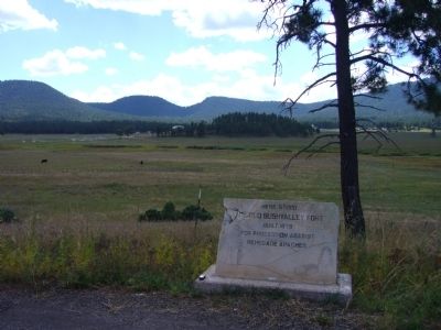
Once owned & often visited by film legend John Wayne, the ranch with the prominent white show barn came to fame in the 1940s as the Milky Way Hereford Ranch, owned by the Mars Candy Family. — — Map (db m36611) HM
This stone chimney is all that remains of a one room country school house that served pioneer Amity pop. 119 from the early 1880's until closing in April 1930. The Amity Cemetery & Amity Ditch are the only other remains of this early Mormon . . . — — Map (db m36614) HM
An early 1900s adobe home built by the son of Eagar's first Mormon Bishop. Crosby, a major sheep & cattle rancher, was a railroad contractor who in 1917 laid the track for the Santa Fe Railroad north of here. — — Map (db m36626) HM
Below among the large cottonwood trees are the historic hdqtrs of Fred T. Colter's Cross Bar Ranch. Originally homesteaded in 1881 by Texan Micajah Phelps, Colter built the ranch into one of the largest cattle operations in Northeastern AZ. — — Map (db m36609) HM
After the original frame school house burned in 1930, this building served Eagar's children for 53 years. Mothers prepared hot lunch across the street creating Eagar's own depression era "soup lines" at 5 cents a cup for the children. — — Map (db m36628) HM
Completed in 1912 by J.P. LeSueur manager of the Eagar ACMI, this frame house with a skin of pressed metal wall sheathing is best known as home to one of the Colter Bros. important Round Valley Ranchers. — — Map (db m36643) HM
Built in the early 1900s by one of Eagar's prominent civic, religious & business leaders, this barn was constructed with wooden pegs & retains remarkable architectural integrity. The 2-story brick farmhouse no longer stands. — — Map (db m36640) HM
Built c.1892, this adobe structure once housed the Eagar School & later a bootlegger's still. Jepson purchased & enlarged the home in 1925 & moved his family from Alpine so his daughters could attend Round Valley High School. — — Map (db m36627) HM
On July 24, 1900, the Peter P. Rencher family arrived from Texas in four wagons & set about building their place in Eagar. Completed in 1913, this 5 bedroom, red brick Colonial Revival home was the crown jewel of their labors. — — Map (db m36618) HM
In 1878, this notorious outlaw gang clashed over dividing their loot. A heated gunfight occurred in the saddle of this hill and it is said that at least seven died. Here lie their last known remains. — — Map (db m36607) HM
This handsome example of Colonial Revival architecture was home to the manager of Round Valley's ACMIs. His wife, the area's first registered nurse, boarded expectant mothers & teachers from the high school. — — Map (db m36645) HM
Think of a word to describe the semi-arid grassland in front of you. Is it lush, green, or forested? No, but those would be accurate descriptions for this land during the Triassic Period. At that time, this area resided on the supercontinent Pangea . . . — — Map (db m269588)
Built of adobe in 1901 with a cast iron front shipped from St. Louis, the ACMI was a branch of the Mormon Cooperative Store system for 17 yrs. It later served the community as a saloon, variety store & furniture emporium. — — Map (db m36652) HM
Gregorio Baca bought this house from G. Becker in 1907 for his bride, Chona Ortega. It's walls are 16" thick adobe. The wealthy Bacas & Ortegas ran large herds of cattle & sheep on vast tracts of land in Concho, St. Johns & The R.V. area. — — Map (db m36383) HM
Part of the Spanish migration from northern New Mexico to Round Valley, Faustin Baldonado & his son Pedro bought this adobe home w/1 foot thick walls in the 1890's. Originally a cantina, Pedro added rooms when he married in 1900. — — Map (db m36382) HM
The oldest continuously operated Ford dealership west of the Mississippi began in the west building in 1910. A pathfinding auto trip blazed the first "ocean to ocean highway" through here. — — Map (db m36379) HM
In 1899, 14 year old Bertha Wahl was murdered here by a shepherd. Just south of here was the original Becker Store. Beyond lie the graves of the Becker family. Due west stood Henry Springer's Mercantile. — — Map (db m36647) HM
H.T. Brawley, teacher and principal of R.V.H.S. began construction on this house in approximately 1925. The unfinished shell sold to the M.J. Wiltbank Family in 1935. M.J. & son Clive completed the home. Through the years teachers, newlyweds & . . . — — Map (db m36595) HM
Built c.1915 & originally called the Apache Theatre, this adobe movie house once showed silent flickers with a hand-cranked projector. Renamed the El Rio in 1937, Round Valley's first theatre is still operating with its original popcorn machine. — — Map (db m36381) HM
Due south rises the 3rd tallest peak in AZ, revered by conservationist, Aldo Leopold Escudilla was home to Ike Clanton of OK Corral fame & Arizona's last grizzly bear. In fall, the north slope is golden with Aspen covering the 23,000 acre fire of . . . — — Map (db m36592) HM
On Dec. 25, 1886, James Hale was gunned down here in front of the Brighton Saloon. His accused was never brought to trial. In 1894 this site, then called Hunter's Hall, held the first Presbyterian services in the Round Valley. — — Map (db m36651) HM
This 10 foot high, 5 ton statue cast by St. Louis sculptor August Leimbach is one of 12 identical monuments to the bold spirit of the pioneers erected in 1928-29 along the National Old Trails Road from Maryland to California. — — Map (db m36380) HM
Just west on the river, W.R Milligan built the first grist mill & sawmill in Round Valley, later a brick kiln was added. Subsequent owners included the Udall Bros. & J.P. Rothlisberger who built the barn just ahead. — — Map (db m158475) HM
These log structures built by Thompson, a Danish convert to Mormonism, are Round Valley's oldest surviving buildings (1879). The cabin hosted the first Mormon services in Springerville. — — Map (db m36385) HM
Begun as missions in the late 1800s, Community Presbyterian Church here, and St. Peter's, a block east, moved into these permanent homes built respectively of brick (1918) & adobe (1928). — — Map (db m36384) HM
Second cousin to famed "Texas John Slaughter", Peter Slaughter & his rough trailhands brought the first Texas cattle to the White Mountains c. 1881 and built his P Lazy S Ranch on the Black River. Pete is buried here with 3 sons & extended family. — — Map (db m228567) HM
This bronze school bell summoned children until 1950. This 2 room adobe with high pitched roof & bell tower was added onto with brick, altering the entry & roof in 1927 & again in 1950. The school served the community 99 years. — — Map (db m36653) HM
1914 Honor roll 1918
Died
in the service of
their country
Richard W. Judd
born Dec 17, 1895 died April 12, 1918
Sidney Severens
born March 24, 1891 died June 7 1918
John H. Slaughter
born April 2, 1889 died October 27, 1918 . . . — — Map (db m195841) WM
This park contains buildings restored by the White Mtn. Historical Society. They preserve early settler, Hispanic, & Native American cultures, along with farming, forestry and ranching heritage. — — Map (db m36594) HM
Built during the great depression using native stone & W.P.A. labor, this twenty-bed facility finally opened in 1939 when a doctor agreed to come to Round Valley to finish, lease & run the hospital for 10 years. — — Map (db m36649) HM
The original dam at this site was destroyed in the spring floods of April, 1915. With the loss of eight lives and severe damage to farmlands. It was rebuilt with loans from the state of Arizona. — — Map (db m136234) HM
The old "Bowery" was the first place of worship used by the members of the Latter Day Saints Church who came to St. Johns in 1879-1880. The Assembly Hall, located on the northwest corner of the public square was erected in 1882. It was built of logs . . . — — Map (db m36586) HM
A pioneer wagon road came through this area and went to Fort Apache, established in 1870. Hay, which was delivered to the fort, was one of the few cash crops in those early days. The road is now covered by Rainbow Lake.
Early sheepmen first . . . — — Map (db m36741) HM
The White Mountain communities dedicate this memorial to the
courageous men and women who voluntarily put themselves in harm's way to protect
from imminent destruction by the Rodeo-Chediski Fire.
By the Grace of God, and through the . . . — — Map (db m36745) HM
These pictographs were made by Native Americans some 800 to 2,000 years ago.
How were they made?
Paint was made from powdered minerals, charcoal or crushed plants and mixed with a binder such as saliva, blood or vegetable juices. A yucca . . . — — Map (db m68674) HM
Full of hope in the spring of 1883 Sadie Richardson arrived at the townsite of Wilford with her husband and four other Mormon families.
They built cabins and corrals for their cattle. They cleared the land and planted corn, potatoes, wheat, . . . — — Map (db m68679) HM
The smell of burning pinyon lingers in the air. You've just enjoyed a bowl of corn meal mush. The corn has been stored since last season and still feeds the family.
Fall is coming. Soon it will be time to gather pinyon nuts and walnuts.
A . . . — — Map (db m68675) HM
From 1915 to 1949 the Heber Ranger Station Stood at this site.
The year is 1910 and you decide you'd like to be a Forest Service Ranger. To pass the test you'll need to know the local country, be able to take care of yourself and your . . . — — Map (db m68676) HM
For 75 years this bell tolled throughout Pinedale Valley as a symbol of unity, calling the settlers to school, church and socials and warning of disaster. Purchased in 1892, it hung for many years in a log schoolhouse near this site. Later it was . . . — — Map (db m36666) HM
In recognition of her unselfish participation and example in community beautification. Serving on the town bicentennial committee, she proposed the covered bridge and the planting of pine trees along the lane north to the highway as being worth . . . — — Map (db m36665) HM
In 1876, Corydon E. Cooley and Marion Clark, two ranchers who had both laid claim to, and eventually became partners in managing 100,000 acres of land at the northwest edge of the White Mountains determined that the land could not support two . . . — — Map (db m36664) HM
In 1870 Corydon E. Cooley, a government scout and Marion Clark entered this valley and located ranches. Cooley built a log house on the hill. By 1876 many families came, including Alfred Cluff, David E. Adams, Thomas W. Adair, Heber Dalton and . . . — — Map (db m36663) HM
One of the remaining one-room brick schoolhouses in Northern Arizona was built in 1900 of fired brick.
The school was named for Charles Shumway who settled in Spring Valley (now Silver Creek Valley) in 1878 and built a grist mill for wheat and . . . — — Map (db m36738) HM
Born December 2, 1834 in Stockholm, New York, son of Silas and Mary Aikens Smith, and first cousin to the Prophet Joseph Smith, he crossed the great plains to the Salt Lake Valley in 1847 with the Mormon pioneers. Called to help colonize Parowan in . . . — — Map (db m36736) HM
A new pioneer settlement was begun on July 21, 1878, when William J. Flake and his wives Lucy and Prudence led five families, their wagons and livestock into this valley. Lucy Flake described the scene as "a beautiful place" with "clear water" and . . . — — Map (db m36717) HM
A.Z. Palmer was one of the original settlers of Snowflake and established the first store there with Mark Kartchner, a brother-in-law. In 1895 he purchased the store located on this site and thereafter became the pre-eminent merchant in the region . . . — — Map (db m36692) HM
Construction began in 1930 by Jane Hatch, Lizzie Willis and Emma Kartchner. The building was neglected for several years and in the early 1950's seven couples agreed to save the home, which became the clubhouse for the 20-30 Club. On November 2, . . . — — Map (db m36695) HM
George P. Hatch married Dora Palmer, A. Z.'s daughter, and later they began an ice cream parlor in A.Z.'s store. When A. Z. Died, they bought out Dora's siblings. Dora's store experience plus George's business college background brought great . . . — — Map (db m36693) HM
In 1945, Reed & Burt Hatch, brothers & partners, purchased this building from the A.Z. Palmer Family, as they had outgrown the building where they operated a thriving general store. After some renovation, the building was renamed "Hatch Bros. . . . — — Map (db m36694) HM
Has been designated a
National Historic Landmark
This site possesses national significance
in commemorating the history of the
United States of America
1964 — — Map (db m36885) HM
Owner
Navajo County, AZ
Design Engineer
American Bridge Company
Rehabilitation Engineer
Jerry A. Cannon
The Little Colorado River formed one of the most formidable obstacles to transcontinental travel across Arizona on Route 66. The . . . — — Map (db m195839) HM