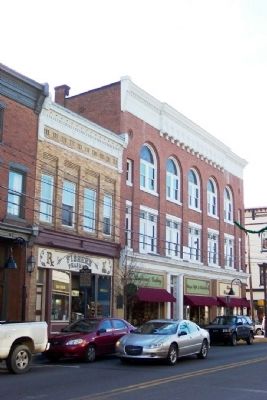
A log structure, built prior to 1761, stood on this site. Known, also, as the Commandants House; later as “Rising Sun Inn.” Occupied by British officers until close of French and Indian War. Destroyed by fire, Dec. 14, 1885. — — Map (db m14004) HM
This Plaque Commemorates the 250th Anniversary of the Survey of the Town of Bedford by John Lukens.
John Lukens was directed to survey and lay out a town by Lt. Gov. John Penn on 05 May 1766. Lukens laid out 200 lots
between 04 June and 14 . . . — — Map (db m176293) HM
Built in 1815. East room housed the first bank in Bedford, known as the Allegheny Bank of Pennsylvania, from 1815 to 1832. Original vault can still be seen. Since 1924, used as public library and community center. — — Map (db m13986) HM
Formed on March 9, 1771 from Cumberland County, it first embraced most of western Pennsylvania. Named for its county seat (formerly Raystown) incorporated 1795. In 1758, Fort Bedford was erected here, and Forbes Road - to become a major highway . . . — — Map (db m13990) HM
(Front):To all her sons who volunteered to defend and perpetuate the government of these United States, Bedford County dedicates this monument July 4, A.D. 1890 Erected in part by the children of the Common Schools of Bedford County . . . — — Map (db m14002) HM
In honor of the men and women of Bedford County who answered the call
We remember these who lost their lives in service to their country
Darrell Zane Magruder •
Donald Clair Wyles •
Charles E Sivits •
Irvin Grant Weyand •
Rodney . . . — — Map (db m14008) WM
Settled about 1750, known then as Raystown. Site of an early trade post and Fort Bedford, 1758. Base for Forbes, Bouquet expeditions. In 1794 Washington here reviewed forces in Whiskey Rebellion. — — Map (db m52662) HM
IN
memory of
CHARLES McDOWELL
who died Feb 20th A.D. 1843
aged 63 years 1 month & 24 days.
The deceased
was a native of Ireland whence he emigrated
to the U.S. in 1795 at the age of twenty five
years. He settled in Bedford . . . — — Map (db m253669) HM
Built about 1771. It was the headquarters of George Washington in October, 1794, when he came to Bedford to review troops assembled here to quell Whiskey Rebellion in western part of the State. — — Map (db m14015) HM
During the early years of the Lincoln Highway, gas and snacks were not nearly as easy to find
as they are today. Individual gas pumps were located in front of stores on the sidewalks.
Early travelers were warned to fill their tank every . . . — — Map (db m253538) HM
This tablet marks the site of the First Court House and Prison Built in 1774 in the prison yard around which was a high stone wall were The Pillory and Whipping Post used in those days for the punishment of criminals.
Prior to the . . . — — Map (db m14000) HM
Depot of supplies assembling place of an army of nearly eight thousand men and the starting point of General John Forbes' Expedition for the possession of Fort Duquesne. The road leads Westward to the Forks. — — Map (db m52666) HM
Philadelphia • Carlisle • Bedford • Ligonier • Pittsburgh
In 1758, at the height of the French & Indian War, British General John Forbes and his troops took on a daunting task: to carve a trail, over 300 miles long, through the Pennsylvania . . . — — Map (db m177005) HM
Site of lots on which John Fraser and his wife established an inn and trading post in 1758. Fraser had been a guide and interpreter for Colonel Washington. The inn provided meals for army officers at Fort Raystown (Bedford). — — Map (db m166918) HM
“First in war - first in peace, and first in the hearts of his countrymen.”
This tablet marks the building used by President George Washington as his headquarters October 19 and 20, 1794, when he was in Bedford, in charge of the United . . . — — Map (db m14089) HM
In 1758 Colonel George Washington led the Virginia troops to Fort Raystown in Central Pennsylvania. Under the direction of Brigadier General Forbes, British and
Provincial troops had been ordered to cut a road 200 miles west and capture the . . . — — Map (db m177139) HM
This millstone, which dates prior to the American Revolution, came from Dutch Corner in Bedford County. Jim Karns found it in 1985 while doing construction work near Imlertown. The mill from which it came is unknown. This stone, which weighs about . . . — — Map (db m91117) HM
Korean War
Killed During The War
Donald L. Bishop 1 Aug 1950 •
John W. Nearhood 8 Aug 1950 •
George Way 8 Sep 1950 •
Harold W. Dorsey Dec 1950 •
Joseph G. Boyer 1 Jan 1951 •
Lemuel R. Bowser 22 Feb 1951 •
Benjamin F. Smith 22 Feb . . . — — Map (db m178853) WM
Raised and equipped the 16th regiment
of Virginia Continentals. Fought at White Marsh Plains 1777 Valley Forge Campaign
1775 1783 — — Map (db m177115) HM
(Statement):
A full transcript of the original Presbyterian Burial Ground Patent is available to all those interested from the Memorial Park Conservancy
In June, 1766, in pursuance of an order from his Honour the Governor John Penn, . . . — — Map (db m176390) HM
This house, built
in 1816 by the Hon.
James Russell, first
burgess of Bedford,
is considered a fine
example of Georgian
style of the Post-
Colonial period. — — Map (db m145062) HM
The Elm Tree which this tablet marks was planted in memory of those Patriots of the Borough of Bedford who gave their lives for the cause of freedom in the Great World War.
Corporal Howard Pardoe Booty, Co. L. 112th U.S. Infantry, 28th . . . — — Map (db m14011) WM
In Memory of those Soldiers
of the American Revolution
buried in this cemetery
Col. Hugh Barclay · Col. Charles Cessna · Col. Samuel Davidson · Col. Levin Powell · Henry Armstrong · George Funk · Bert Gibson · Frederick Hill · Joseph . . . — — Map (db m176783) WM
This tablet erected by Bedford Penn'a Chapter Daughters of the American Revolution
May 30, 1925
Marks the site of Fort Bedford
One of the Frontier Forts built by the British in 1758
The stockade enclosing the fort contained about 7000 . . . — — Map (db m166796) HM
[Honor Roll of Veterans]
Allen D. Oster • Donald Geisler • Arthur P. Hartle
Wm. C. Shipe, Jr. • Warren E. Sams • John E. Thomas
Jack H. Pepple • Joseph Courdriet • Earl Weight
Lester R. Cussins • Milton P. Boore • Chauncey . . . — — Map (db m180181) HM
Medicinal values of these springs discovered about 1796. It soon became a leading resort visited by numerous notables. James Buchanan used the Springs as his summer White House while President. — — Map (db m202853) HM
The Bedford Springs Historic District consists of a mineral springs resort established c.1806 by Dr. John Anderson. The district's oldest extant buildings are the stone Nawgel's Mill, c.1796, and the log Miller's House, c.1800. In 1804, Nawgel . . . — — Map (db m202855) HM
Settled about 1750, known then as Raystown. Site of an early trading post and Fort Bedford, 1758. Base for Forbes, Bouquet expeditions. In 1794 Washington here reviewed forces in Whiskey Rebellion. — — Map (db m13995) HM
Settled about 1750, known then as Raystown. Site of an early trade post and Fort Bedford, 1758. Base for Forbes, Bouquet expeditions. In 1794 Washington here reviewed forces in Whiskey Rebellion. — — Map (db m82781) HM
Generating pristine water for centuries, The Black Spring is named for the Black family who lived on the land over 200 years ago. Producing over 600,000 gallons of water per day, it supplies nearby Red Oak Lake as well as potable water used to . . . — — Map (db m224848) HM
The Iron Spring, which also has been called Fletcher's Spring or the Upper Spring issues forth copiously from a fissure in limestone outcroppings on the upper part of Shober's Run. This highly mineralized water is similar to the nearby Mineral . . . — — Map (db m224849) HM
Modern road construction methods have evolved utilizing multiple sub grade & substrate layers of compacted earth, crushed stone, concrete, asphalt and can measure up to 36" in depth creating a stable smooth driving surface. Construction of the . . . — — Map (db m116487) HM
This is one of the original service plazas for the nation's first long-distance superhighway. On October 1, 1940, the Turnpike opened, stretching 160 miles from Irwin to Carlisle. The Turnpike Commission had been created in 1937; construction . . . — — Map (db m308156) HM
This is one of the original service plazas for the nation's first long-distance superhighway. On October 1, 1940, the Turnpike opened, stretching 160 miles from Irwin to Carlisle. The Turnpike Commission had been created in 1937; construction . . . — — Map (db m308157) HM
In 1936 seventy-five percent of Pennsylvania farms had no electric service. During the next five years, with Federal support, 14 consumer-owned cooperatives were formed in this State. Bedford Rural Electric Cooperative, which serves members in . . . — — Map (db m52665) HM
The increased number of automobiles during the Lincoln Highway era (1912-1940) led to the development of programmatic architecture. Proprietors took daring approaches to appeal to the new motoring public.
All across the country, oversized . . . — — Map (db m13998) HM
Nearly three centuries of transportation history can be found in Pennsylvania: native American paths to wagon trails, early canals and railroads, the Forbes and Burd Roads, and a string of ten other turnpikes. However, none were more important in . . . — — Map (db m166856) HM
From June 27-July 8, 1861 a newly formed brigade of 1,500 Union troops under Chas. J. Biddle consisting of the 5th and 13th (Bucktail Regiment) PA Reserves, and 1st PA Res. Artillery, encamped here while enroute to relieve Col. Lew Wallace’s 11th . . . — — Map (db m288780) WM
Near this site on July 30, 1758, Cols. Bouquet and Washington discussed proposed routes by which Gen. Forbes’ army would attack French Ft. Duquesne. Bouquet preferred the route due west from Bedford, while Washington advocated Braddock’s 1755 road . . . — — Map (db m84287) HM
Founded 1681 by William Penn as a Quaker Commonwealth. Birthplace of The Declaration of Independence and The Constitution of the United States — — Map (db m91128) HM
Mail was delivered here on foot over Wills Mtn. from the B&O Railroad in Hyndman, PA. The 4 mile Mail Path was used from 1871 until 1923. Mail was also delivered 4 more miles over Evitts Mtn. to Bean's Cove. After 1923, mail arrived here via Blue . . . — — Map (db m84288) HM
This inn at the junction of the Forbes and Burd Roads was operated, 1779-1815, by Jean Bonnet and his heirs. In mid-1794, during the Whiskey Rebellion, embattled farmers met here and raised a liberty pole to protest the federal excise tax on . . . — — Map (db m60115) HM
This intersection marks the point where Forbes Road
of 1758 diverged from the path cut by Col. Burd in
1755. The Forbes Road led through the wilderness
west toward Ligonier from this point. — — Map (db m59734) HM
The Forks
The Road cut by Colonel James Burd
in 1755 and the Forbes Road diverge here,
Forbes Road leading southwestward to Shawnee
Cabins Encampment 4 1/2 miles from Fort Bedford. — — Map (db m166740) HM
For over 200 years, Bedford County taverns have served as stopovers for weary travelers en route to Pittsburgh or Philadelphia. Over the years, most of these taverns have ceased to operate. However, the Jean Bonnet Tavern continues to offer a fine . . . — — Map (db m60116) HM
Nearby water gaps have made this an important transporation corridor for thousands of years. Native American trails, 18th century military roads, the Pennsylvania Road, the Chambersburg and Bedford Turnpike, the Lincoln Highway, US 30, and the . . . — — Map (db m52667) HM
During World War II, the Gateway was considered to be a major stop-off for many servicemen and women who were on their way to Maryland, Virginia, the Carolinas and westward. This prime location near the turnpike interchange in Breezewood and along . . . — — Map (db m337) HM
Shortly after the Pennsylvania Turnpike opened in 1941, Snyder's Gateway Inn was one of the first businesses to appear. Merle and Marian Snyder opened the restaurant shortly before World War II began and eventually supplied fuel to the military . . . — — Map (db m167357) HM
Dedicated to the men of the Buffalo Mills area who have honorably served in the Armed Forces of the United States in time of War
Walter Adams • George Bingman • Walter Bingham • Paul Bittner • Eugene Bohn • Charles Brown • Mason Bullington • . . . — — Map (db m176933) WM
Erected 1929 A.D. by the
Commonwealth of Pennsylvania
to the memory of
Ludwick Lybarger Sr. • George Lybarger • Nicholas Lybarger Sr. • Nicholas Lylarger Jr. • Henry Lybarger
Soldiers of the Revolutionary War
who served in
"Wills Creek . . . — — Map (db m176117) WM
Located just a stone's throw from the Forbes Road (later the Lincoln Highway), the Everett Foundry and Machine Shop was the place to go for machine parts, welded pieces, molds or bells. The business was started in 1854 by Josiah and Jeremiah . . . — — Map (db m134810) HM
[Center plaque:]
To those who
served our country
in time of war
☆ ☆ ☆
They gave their today
for our tomorrow
[Left plaque]
In loving memory
of all Rebekahs
and Odd Fellows
[Right . . . — — Map (db m135658) WM
In the early 1900s two local boys made a name for themselves in the automobile world. Chester (Chet) and Clayton Karns of Everett were pioneers in the automobile industry. The American Automobile Association (AAA) recognized the brothers as the . . . — — Map (db m134815) HM
The village of Bloody Run, later named Everett, was planned by Michael Barndollar in 1785. Barndollar also built the Union Hotel at this site in 1808. It was known as one of the finest hotels in existence at that time. During the flood of 1936 . . . — — Map (db m134813) HM
At the end of the 1800s, most people lived less than 20 miles from a railroad station. By the early 1900s new paving techniques created opportunities for improved roads, like the Lincoln Highway. With automobile travel there were new levels of . . . — — Map (db m134812) HM
At the Juniata Crossings, half a mile north of here, General Forbes erected a small stockade in 1758 to protect the communications of his army moving west to attack Fort Duquesne. — — Map (db m52663) HM
Entrenchments still visible by the roadsides were prepared in June, 1863, by militia under Col. J.C. Higgins against threatened Confederate attack toward the railroad at Altoona. The march of troops toward Gettysburg on June 30-July 1 ended the . . . — — Map (db m54182) HM
Travel reached its peak with the birth of automobiles. For the sake of convenience and price, motor camping was soon the latest trend. However, it wasn't long that travelers wanted heat, water, food and gas. As a result, entrepreneurs had the . . . — — Map (db m166739) HM
Constructed 1996-1997
Co. Commissioners: Norma C. Ickes, Chairperson • Dick M. Rice • Gary W. Ebersole
Engineer: P. Joseph Lehman, Inc.
Contractor: Carmen Paliotta Contracting Company
History of the Bridge
In 1882, a . . . — — Map (db m251344) HM
Even when blessed with good roads and good weather, crossing the Alleghenies on the Lincoln Highway was a challenge for the early motorist. Steep grades and winding roads resulted in overheated engines and severe cases of vertigo. Entrepreneurs . . . — — Map (db m61117) HM
By 1923, motor camping was the number one national pastime. Automobiles provided average Americans a new type of freedom and a way to escape their daily routine by touring the countryside on short weekend trips or cross-country treks. But it . . . — — Map (db m120992) HM
In 1936 seventy-five percent of Pennsylvania farms had no electric service. Over the next five years, in response to their needs, 14 consumer-owned cooperatives were formed in this State. Serving users in Bedford, Fulton and Huntingdon counties, New . . . — — Map (db m91087) HM
Top Marker
Friends Cemetery
Founded 1794
Originally 6 acres of ground was purchased from William Webb, Frederick County, Maryland, for 15 shillings per acre, August 30, 1794, by "Members of the Society of People called Quakers to . . . — — Map (db m114345) HM
Before and during the Civil War, Benjamin Walker, Abner Walker, Sr. and George Harbaugh worked closely with African American Underground Railroad conductors John Fiddler, Elisa Rouse and Joseph Crawley. Hundreds of fugitive slaves were led from the . . . — — Map (db m91088) HM
This bell is all that remains of the school house, that once stood on these grounds. Purchased by the Pleasantville Borough at a cost of $1,500.00. The two story structure with bell tower, measuring 38 ft. x 40 ft. was built by Thomas S. Holsinger. . . . — — Map (db m114434) HM
Rebuilt in 2004
Co. Commissioners: Steven K. Howsare, Chairman
Dick M. Rice • Glenora H. Faupel
Contractor: Kee-Ta Quay Construction
Restored in 1995
Co. Commissioners: Dick M. Rice, Chairman
Elaine M. Sollenberger • Gary W. Ebersole . . . — — Map (db m263028) HM
Capt. William Phillips and 11 men of his militia company were captured near this point by Indians, July 16, 1780. Ten men were killed here and were buried later by a search party. Capt. Phillips and son Elijah, taken prisoner, were freed by British . . . — — Map (db m91084) WM
Near here was located Shawnee Cabins camp. Used by Gen. Forbes army in the campaign of 1758 against the French at Fort Duquesne in present Pittsburgh. — — Map (db m8288) HM
Shawnee Cabins Encampment
At this point
the Forbes Road
leads southwestward
to
the eastern slope
of
the Allegheny Mountains
8 1/3 miles from Fort Bedford — — Map (db m49562) HM
In the early days of the automobile, owning a car was considered a novelty. It was also considered a major expense. People had to buy cars outright in cash. As a result it was not surprising that owners wanted to protect their investment by parking . . . — — Map (db m122137) HM
A village site nearby on the Raystown Path. Named for a group of Shawnee Indians who halted here on their retreat from the Potomac to the lower Allegheny valley in the early 18th century. — — Map (db m8290) HM
One of the nation's earliest cooperative
extension offices was established in 1910
in Schellsburg, Bedford County, with A.B.
Ross as county agent. The innovative
program sought to educate farmers about
agricultural science to increase . . . — — Map (db m176111) HM
To all Veterans who served their country in defense of freedom
(Rear):
Schellsburg area
Veterans Memorial
Dedicated
November 11, 1985 — — Map (db m176114) WM
1325 entries matched your criteria. The first 100 are listed above. Next 100 ⊳