On May Street South just south of Donald Street East, on the right when traveling south.
Thunder Bay’s annual 10-Mile Road Race in May is one of the oldest foot races in Canada. First run in 1910 through the streets of Fort William and Port Arthur, it effectively linked the two rival cities. Created to encourage “healthy and clean . . . — — Map (db m244243) HM
On Court Street North just north of Cooke Street, on the right when traveling north.
The Court Street Fire Hall, built in 1906, was designed by Port Arthur Architect, Thomas Hanley. The brick two-storey structure was designed for horse-drawn fire wagons with access provided by four round-arched wooden doors. A one-storey tower at . . . — — Map (db m227985) HM
On Donald Street East at Ross Street, on the left when traveling east on Donald Street East.
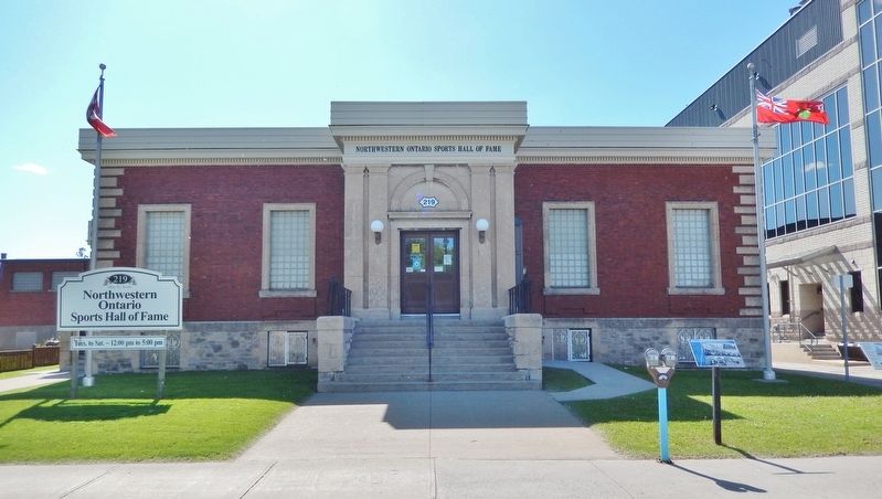
This Edwardian-style building was designed by Robert E. Mason, and constructed by Michael Braden in 1910 as a court house and police station combined. The placement of the two pilasters on the façade creates the impression that four columns exist . . . — — Map (db m227965) HM
On Sleeping Giant Parkway just north of Pearl Street, on the right when traveling north.
Origin Stories The rock, the water, the oral traditions of the First Nations: Each tells its own tale about the origins of this shoreline site, but all speak of a place that is ancient. Geologists talk in terms of glaciers. The first . . . — — Map (db m227996) HM
On Arundel Street just west of Lyon Boulevard, on the right when traveling west.
Constructed in 1912 by Seaman and Penniman, this single span bridge was designed by Joachim Antonisen to harmonize with the beauty and grandeur of the landscape. Featuring arch ribs and open spandrels, its unadorned functionalism and use of . . . — — Map (db m195890) HM
The dynamic "Minister of Everything", Massachusetts-born Clarence Decatur Howe immigrated to Canada in 1908 and established an engineering firm in Port Arthur in 1916. Elected to the House of Commons in 1935, he was a dominate figure in Liberal . . . — — Map (db m107352) HM
Near Montreal Street, 0.4 kilometers east of Neebing Avenue.
"Can Car" was the main plant of Canada's largest aircraft manufacturer during the Second World War. Here, workers built 1,451 of the reliable Hawker Hurricanes that won renown in the battle of Britain and 835 Curtiss Helldivers, significantly . . . — — Map (db m106692) HM
Near Sleeping Giant Parkway, 0.4 kilometers north of Pearl Street, on the right when traveling north.
Thunder Bay’s Stone Frigate Her Majesty's Canadian Ship Griffon was launched modestly, in a leased garage a few blocks from this waterfront with its White Ensign flying from a tree trunk felled in the bush. But from the start, . . . — — Map (db m227989) HM
Near Sleeping Giant Parkway, 0.3 kilometers north of Pearl Street, on the left when traveling north.
Joining rail and water transportation, this station, which was built in 1905 at Port Arthur and which formed the end of the line from Winnipeg, was designed in what was commonly called the Canadian Railway style by Winnipeg architect, R.B. Pratt. . . . — — Map (db m227999) HM
On Algoma Street South close to Red River Road, on the right when traveling south.
Designed by Robert J. Edwards, the school was erected in 1884. In 1901, an eight-room classroom structure, designed by C.W. Wheeler, was added. The two-storey brick structure has a symmetrical facade and the straightforward design is ornamented . . . — — Map (db m195889) HM
On May Street South just south of Donald Street, on the right when traveling south.
Thunder Bay's current city hall had two predecessors. The first (visible at right) was built in 1893. It housed Fort William's civic offices and served as a venue for community events and entertainments. It also accommodated Fort William's . . . — — Map (db m244242) HM
On Waverley Street at Secord Street, on the right when traveling west on Waverley Street.
This celebrated Canadian army nurse and public health authority was born in Port Arthur. In 1909 "Beth" Smellie became night supervisor at McKellar General Hospital. Joining the Royal Canadian Army Medical Corps in 1915, she served in France and . . . — — Map (db m106976) HM
Near Selkirk Street South at Ridgeway Street East, on the right when traveling south.
Tree Planted by The Honourable Lynn McLeod and Jack Adderly in 1990 to commemorate the 100 millionth tree planted by Abitibi-Price Inc. in Ontario — — Map (db m243999) HM
On Red River Road at Waverley Street, in the median on Red River Road.
This square was named in 1936 for Prince Arthur, Duke of Connaught, third son of Queen Victoria. He was serving in Canada with his regiment in 1870, when Colonel Wolseley named Prince Arthur's Landing (later Port Arthur) in his honour. Created Duke . . . — — Map (db m107067) HM
On Colonel Keene Drive at High Street South, on the right when traveling east on Colonel Keene Drive.
At least 9,000 years old, the Cummins site is one of the most significant of several Palaeo-Indian archaeological sites that form the Lakehead Complex. Many of these early seasonal camps were located on the shoreline of ancient Lake Minong, at a . . . — — Map (db m106858) HM
Near Montreal Street, 0.4 kilometers east of Neebing Avenue.
Elsie MacGill made remarkable contributions to aeronautical engineering by introducing mass-production techniques for the Hawker Hurricane built here during the Second World War and later by developing international air-worthiness regulations. . . . — — Map (db m106696) HM
On Donald Street East at May Street South, on the right when traveling east on Donald Street East.
A small fort was established near here in 1717 by a French officer, Zacharie Robutel de la Nouë. First of a projected series of bases en route to the "Western Sea", it replaced a structure built in 1679 by Daniel Greysolon, Sieur Dulhut, on another . . . — — Map (db m106760) HM
On Arthur Street East, 0.1 kilometers east of Brunswick Street South, on the right when traveling east.
In aboriginal times the Kaministikwia river was an important link between the Great Lakes and the northwest, and from the late 17th century French posts here at its mouth served as bases for the penetration of the interior. Between 1804 and 1821 . . . — — Map (db m106755) HM
On McNaughton Street at McTavish Street, on the right when traveling east on McNaughton Street.
When the boundary settlement of 1783 placed its major inland depot, Grand Portage, in U.S. territory, the North West Company was forced to seek a new site on British soil. Following the reopening of the Kaministikwia route a new post, later named . . . — — Map (db m106757) HM
Near Waverley Street just east of Banning Street, on the right when traveling east.
It was here on June 11, 1923, that the General Assembly of The Presbyterian Church in Canada, after two days of vigorous debate, voted decisively in favour of the Presbyterians uniting with the Methodists and the Congregationalists to form the . . . — — Map (db m227975) HM
Near Marina Park Drive at Marina Park Overpass, on the right when traveling north.
This historic stone was embossed with the letters C.P.R. in 1907 for display under the peak of the roof of the Canadian Pacific Railway Station at Port Arthur. Commonly called Tyndall stone, it is dolomitic limestone weighing 1500 pounds and comes . . . — — Map (db m228000) HM
Near Red River Road just east of Regent Street, on the right when traveling east.
The fountain was a gift to the City of Port Arthur from Mrs. Madge Hogarth in honour of her husband Major General D. M. Hogarth, an early industrialist, sportsman, soldier and politician. Originally from Luton Hoo Mansion, Hitchen, Hertfordshire, . . . — — Map (db m244244) HM
On Red River Road just east of Algoma Street North, on the left when traveling east.
A.L. McGovern • R.H. Clarke • C. Vincent • B. Clavet • J. Jeffs • J. Heffernan • J. Morrison • C. King • J. Bougie • W. Jeffs • E. J. McCartney • J. Audray • H. Nadon • M. Sauve • P.J. Moriarty • R. Taylor • J. Deagle • A. Pariseau • W. Malott • N. . . . — — Map (db m244104) WM
Near Sleeping Giant Parkway, 0.2 kilometers north of Pearl Street, on the right when traveling north.
Cathedrals, Pyramids and Hospitals Canada's famous photographer Yousuf Karsh called them cathedrals. Europe's most influential architects compared them to the pyramids. At one time, there were 29 grain elevators on this waterfront. . . . — — Map (db m227991) HM
Near Sleeping Giant Parkway, 0.5 kilometers north of Pearl Street, on the right when traveling north.
A Joint Venture of the Peng You Taiji Quan Association and The City of Thunder Bay: Martial Arts Capital of Canada Taiji (or Tai Chi) an ancient Chinese martial art — a form of wushu — is performed with slow, carefully controlled movements . . . — — Map (db m243796) HM
In response to a brief from Lakehead educators and business representatives outlining northwestern Ontario's need for an institution of higher education, a provincial Order-in-Council established the Lakehead Technical Institute in 1946. Two years . . . — — Map (db m106857) HM
On Red River Road just west of Algoma Street South, on the left when traveling west.
Live theatre has been part of life at the Lakehead since the 1800s. Many amateur companies performed dramas, comedies and even full-fledged operas. In addition, professional troupes made regular stops here, nurturing a wide audience base. The . . . — — Map (db m243798) HM
Near Sleeping Giant Parkway just north of Pearl Street, on the right when traveling north.
Paddling to the Depot Bark peeled from a birch tree felled in spring. Cedar branches, tamarack roots, spruce pitch, and charcoal. From those materials, the first mariners of Lake Superior — the ancestors of the present-day First . . . — — Map (db m227995) HM
Near Sleeping Giant Parkway, 0.4 kilometers north of Pearl Street, on the left when traveling north.
[English] On Thunder Bay just north of Fort William, engineer Simon Dawson established the eastern terminus of the Canadian government's proposed land and water route connecting Lake Superior and the Red River, for . . . — — Map (db m199597) HM
On Red River Road just west of North Water Street, on the right when traveling west.
For many decades, lake commerce was the life's blood of the community and the focus of much business activity. Port Arthur and Fort William, which joined in 1970 to become Thunder Bay, once fought over who had the better harbour. But things changed . . . — — Map (db m243799) HM
On Red River Road just east of Regent Street, on the right when traveling east.
Erected in commemoration of the men and women of this city who died on the field of honour in war that Canada might maintain her heritage of freedom 1914-1918 1939-1945 1950-1953 — — Map (db m244241) WM
Near Red River Road close to Regent Street, on the right when traveling east.
Designed by Henry Simpson of Toronto with George H. Otto, general contractor, this structure was built in 1909 with classrooms being added in 1925, 1954, and a new gymnasium in 1972. The original design has medieval and Flemish architectural . . . — — Map (db m195886) HM
On Sleeping Giant Parkway, 0.4 kilometers north of Pearl Street, on the left when traveling north.
The First Highway to the West Continents and oceans, geography and history, the Great Lakes and the inland waterways: they all meet here, on this waterfront, at the mouth of a river called the Kaministiquia. The name has been . . . — — Map (db m227997) HM
On Colonel Keene Drive at High Street South, on the right when traveling south on Colonel Keene Drive.
Born in Scotland, Dawson emigrated to Canada as a young man and began his career as a civil engineer. In 1857 as a member of a Canadian government expedition, he surveyed a line of road from the Lakehead to Fort Garry and in 1858-59 further . . . — — Map (db m106859) HM
On Cumberland Street North, 0.1 kilometers north of Van Norman Street, on the right when traveling north.
Born in Chelsea, Illinois, Van Horne, after a brilliant career with a number of railway companies in the mid-western United States, accepted the position of general manager of the Canadian Pacific Railway in 1881. Construction of this pioneer . . . — — Map (db m107350) HM
On Trans-Canada Highway (Provincial Highway 17) 2 kilometers east of Hodder Avenue, on the right when traveling west.
"Dreams are made if people only try. I believe in miracles... I have to... Because somewhere the hurting must stop." Terry Fox inspired this nation with his dream - his MARATHON OF HOPE - a cross-Canada run to raise money for cancer research. . . . — — Map (db m107355) HM
Near Trans-Canada Highway (Provincial Highway 17) 2 kilometers east of Hodder Avenue.
While in remission from cancer, Terry Fox set out to run across Canada in 1980 to raise money for cancer research. Despite having lost his right leg to the disease, this determined athlete ran 5,373 kilometres - nearly a marathon a day for 143 . . . — — Map (db m107354) HM
On Agora Circle, 0.1 kilometers south of Oliver Road, on the left when traveling south.
This boulder composed of 15 tonnes of massive copper, zinc, and lead ore with gold and silver values was discovered in Aldina Twp. west of Thunder Bay by local prospector Dan Calvert. It symbolizes the significance of the mining industry to the . . . — — Map (db m244000) HM
On Leith Street at Brodie Street North, on the right when traveling west on Leith Street.
In 1812, the Earl of Selkirk settled dispossessed Scottish highlanders on Red River valley lands granted by the Hudson's Bay Company. The HBC's rival in the fur trade, the North West Company, feared the new colony would block its trade and . . . — — Map (db m106761) HM
On Park Avenue just east of Secord Street, on the right when traveling east.
This Armoury is dedicated to the memory of Major Christopher Patrick John O'Kelly, VC, MC of the 52nd (New Ontario) Battalion, Canadian Expeditionary Force. The then Captain O’Kelly was awarded the Victoria Cross for his actions at the Battle of . . . — — Map (db m227998) HM WM
On Cumberland Street South at Lincoln Street, on the right when traveling south on Cumberland Street South.
The “new” Ottawa House was rebuilt on this site in 1888, after fire had destroyed two wooden hotels built earlier in the decade. A major addition was made in 1901, with the architectural detailing carefully matched. The façade features ornate . . . — — Map (db m227961) HM
Near Sleeping Giant Parkway, 0.4 kilometers north of Pearl Street, on the left when traveling north.
The Economic Engine of the Lakehead Wheat from the west, coal from the east. White pine from the woods, whitefish from the lakes. Barley and beef, iron and ice. From the 1880s to the mid-1900s, the railroad carried thousands of tons of freight . . . — — Map (db m243797) HM
On Red River Road at Algoma Street North, on the right when traveling west on Red River Road.
Born in Carlisle, England, Baxter came to Canada as a child. He studied in Toronto and at the Sulpician College in Montreal before becoming, reputedly, the first English-speaking Jesuit novice in Canada. After his ordination in New York in 1854, he . . . — — Map (db m107065) HM
On Red River Road at North Water Street, on the right when traveling west on Red River Road.
Constructed in 1909 as the Industrial Development and Publicity Bureau by the City of Port Arthur, as a special building for the purpose of furthering the industrial and general development of the city. Designed by H. Russell Halton of Fort . . . — — Map (db m243800) HM
On Syndicate Avenue South at Ridgeway Street East, on the right when traveling north on Syndicate Avenue South.
In June, 1875, the first sod on the Canadian Pacific Railway's line from the Lakehead to the West was turned at Fort William. A government contract of that year called for the building of a line northwest towards Lake Shebandowan. In 1882 the . . . — — Map (db m106758) HM
On Brodie Street South north of Arthur Street East, on the right when traveling north.
The Thunder Bay Public Library came into being following the amalgamation of Fort William and Port Arthur in 1970. Prior to this, each city had its own library system. Both libraries emerged in the late 1800s and grew into strong community and . . . — — Map (db m195870) HM
On Red River Road at N Water Street, on the right when traveling west on Red River Road.
This tourist kiosk was erected in 1909 to promote Port Arthur's social and economic merits to visitors and investors. Its eye-catching architecture and strategic location reflect civic boosterism and the city's rivalry with nearby Fort William . . . — — Map (db m107068) HM
On Waverly Street just west of Algoma Street South, on the right when traveling east.
A century ago, in November 1871, upon part of this site in what was then known as Prince Arthur’s Landing, Methodism came into existence in this area by the establishment of Providence Methodist Church, the first Protestant church in the territory. . . . — — Map (db m199600) HM
On Waverley Street just west of Algoma Street South, on the right when traveling east.
The city of Port Arthur’s first Methodist Church was built on this site in 1871. The present church, built in 1905 as the “Methodist Church,” was renamed “Trinity Methodist Church” in 1908. Architects were Langly-Langly from Toronto who designed . . . — — Map (db m244202) HM
On King Road, 1.2 kilometers south of Broadway Avenue.
In the late eighteenth century, most of the fur traders using the Ottawa River-Great Lakes canoe route into the interior of North America belonged to the North West Company, which used Fort William as its inland headquarters. To the north, the . . . — — Map (db m96414) HM
On Van Norman Street at Cumberland Street North, on the right when traveling north on Van Norman Street.
Built in 1913, this magnificent eight story "skyscraper" was commissioned by James Whalen and designed by Brown and Valance of Montreal to resemble the Chicago Style and promote the City of Port Arthur as the "Chicago of the North." The exterior . . . — — Map (db m195872) HM
On Donald Street East at May Street South, on the right when traveling east on Donald Street East.
Born in Inverness-shire, Scotland, McGillivray joined the North West Company in 1784, became a partner in 1790 and its principal director in 1804. Fort Kaministiquia, the Company's wilderness headquarters, was renamed Fort William in his honour in . . . — — Map (db m106759) HM