On Trappe Road (County Route 619), on the right when traveling south.
(Preface): After Confederate Gen. Robert E. Lee's stunning victory at Chancellorsville in May 1863, he led the Army of Northern Virginia went into the Shenandoah Valley, then north through Maryland and across the Mason-Dixon Line into . . . — — Map (db m41655) HM
On John Mosby Highway (U.S. 50) at Hill Road / Trappe Road (County Route 619), on the right when traveling east on John Mosby Highway.
After Confederate Gen. Robert E. Lee's stunning victory at Chancellorsville in May 1863, he led the Army of Northern Virginia west to the Shenandoah Valley, then north through central Maryland and across the Mason-Dixon Line into . . . — — Map (db m3753) HM
On John S. Mosby Highway (U.S. 50), on the right when traveling east.
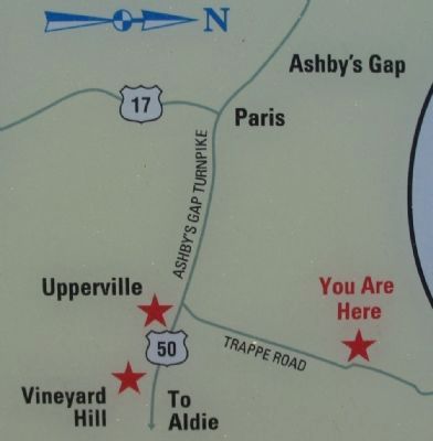
This site, known during the war as Vineyard Hill, commands a clear view of the road, stone walls, and fields in front of you where 10,000 cavalry and infantry clashed in the Battle of Upperville on June 21, 1863. It was the fifth day of attack and . . . — — Map (db m1550) HM
On Vint Hill Road (Virginia Route 215) at Lee Highway (U.S. 15/29), on the right when traveling north on Vint Hill Road.
(Preface): On October 19, 1863, 12,000 Confederate and Union cavalry clashed at the Battle of Buckland Mills in the last large-scale Confederate victory in Virginia. Gen. J.E.B. Stuart, screening the Confederate infantry’s march to Culpeper . . . — — Map (db m174872) HM
On North Calhoun Street, on the right when traveling north.
Judge Edward M. Spilman of the Fauquier County Circuit Court constructed this house in 1859-61. James Keith, who served in the Black Horse Cavalry and later became president of the Supreme Court of Appeals of Virginia, acquired it in 1869. John . . . — — Map (db m7750) HM
On Colonial Road at U.S. 29 on Colonial Road. Reported missing.
For Gen. J.E.B. Stuart and his Confederate
cavalry, the 1863 campaigns brought fewer
victories against the improving cavalry corps
of the Union Army of the Potomac—that is,
until October 19, 1863.
Here on Chestnut Hill the . . . — — Map (db m117053) HM
On Main Street (Business U.S. 15) at Courthouse Square, on the right when traveling east on Main Street.
Although Warrenton was spared the ravages of major battles during the war, control of the town changed hands 67 times and many homes and churches housed soldiers or were used as hospitals. Warrenton was the home of several notable Confederates . . . — — Map (db m151305) HM
On Waterloo Street (Business U.S. 211) at Ashby Street, on the left when traveling west on Waterloo Street. Reported permanently removed.
Although Warrenton was spared the ravages of major battles during the war, control of the town changed hands 67 times and many homes and churches housed soldiers or were used as hospitals. Warrenton was the home of several notable Confederates . . . — — Map (db m167480) HM
On West Lee Street at South Chestnut Street, on the left when traveling west on West Lee Street. Reported permanently removed.
The gate to your right opens to Warrenton
Cemetery, the final resting place of 986 Confederate soldiers, of every Southern state, about
650 casualties of the Civil War. Many wounded
Confederates were evacuated to Warrenton and
vicinity after . . . — — Map (db m117019) HM
On South Chestnut Street at West Lee Street, on the left when traveling south on South Chestnut Street.
The gate to your right opens to Warrenton Cemetery, the final resting place of 986 Confederate soldiers, of every Southern state, about 650 casualties of the Civil War. Many wounded Confederates were evacuated to Warrenton and vicinity after the . . . — — Map (db m151310) HM
On South Main Street at South Street, on the left when traveling south on South Main Street.
The war seemed far from Franklin when Union forces captured Roanoke Island and the North Carolina Sounds in February 1862. In May, however, when they occupied Norfolk and Suffolk to control both coastal Virginia and North Carolina, suddenly the . . . — — Map (db m18135) HM
On South Main Street at South Street, on the left when traveling south on South Main Street.
Before the Civil War erupted, Franklin became a regional transportation and commercial center for the Blackwater-Chowan River basin because the seaboard and Roanoke Railroad connected with steamship lines here. When the war began, the town . . . — — Map (db m18133) HM
On South Main Street at South Street, on the left when traveling south on South Main Street.
To protect Richmond from a Union attack from Suffolk, Confederate authorities fortified the Blackwater River in 1862. You are standing on the Blackwater Line. The intermittent earthworks stretched fifty miles from north of Zuni to the North . . . — — Map (db m18134) HM
On Old Hollow Road, on the right when traveling west.
This is the childhood home of Jubal Anderson Early, who was born on November 3, 1816. He graduated from the U.S. Military Academy at West Point in 1837 and served as a lieutenant in the Seminole War in Florida before resigning in 1838. He practiced . . . — — Map (db m87172) HM
On Indian Hollow Road (Virginia Route 679) at North Frederick Pike (U.S. 522), on the right when traveling west on Indian Hollow Road.
In June 1863, Confederate Gen. Robert E. Lee marched his infantry from Culpeper County to the Shenandoah Valley to launch his second invasion of the North. First, however, he had to capture Winchester, the largest town on his line of communication, . . . — — Map (db m2645) HM
On North Buckton Road (Virginia Route 842) at Larrick Lane, on the right when traveling west on North Buckton Road.
(Preface): The fertile Shenandoah Valley was the "Breadbasket of the Confederacy" as well as an avenue of invasion. Confederate Gen. Jubal A. Early's march north and his raid on Washington, D.C., in June-July 1864 alerted Union Gen. Ulysses . . . — — Map (db m78137) HM
On Main Street (U.S. 11) south of Fairfax Street (Virginia Route 277), on the right when traveling north.
On May 26, 1864, Union Gen. David Hunter marched south from Cedar Creek near Winchester to drive out Confederate forces, lay waste to the Shenandoah Valley, and destroy railroads at Lynchburg. His raid was part of Gen. Ulysses S. Grant's . . . — — Map (db m158593) HM
On Valley Pike (U.S. 11), on the right when traveling north.
As the Federal army attempted to conquer and hold the Valley in 1864, its lines of supply and communication were extended and became susceptible to attack by bands of Confederate partisans. On May 24, 1864, under orders from Union Gen. David . . . — — Map (db m41658) HM
On Jordan Springs Road (County Route 664), on the right when traveling east.
During the Civil War, both United States and Confederate forces used Jordan Springs resort as a hospital at different times. Wounded and sick Confederate soldiers from the Antietam and Gettysburg battlefields came to the springs—although . . . — — Map (db m2358) HM
On Milburn Road (County Route 662) at Old Charlestown Road (County Route 761), on the right when traveling south on Milburn Road.
In the spring of 1863, Confederate Gen. Robert E. Lee and the Army of Northern Virginia began a march that culminated at the Battle of Gettysburg. Lee chose the Shenandoah Valley for his invasion route. Ninety-six hundred Federals under Gen. . . . — — Map (db m41659) HM
On Milburn Road (County Route 662) at Old Charlestown Road (County Route 761), on the right when traveling south on Milburn Road. Reported missing.
On September 19, 1864, Union Gen. Philip H. Sheridan’s Army of the Shenandoah routed Confederate Gen. Jubal A. Early’s Valley Army at the Third Battle of Winchester (also called Opequon) in the bloodiest and largest battle in the Shenandoah Valley. . . . — — Map (db m100977) HM
On Martinsburg Pike (U.S. 11), on the right when traveling south. Reported damaged.
Confederate Gen. Jubal A. Early attacked the defenses of Washington, D.C., in July 1864, then retreated to the Shenandoah Valley. Union Gen. Horatio G. Wright pursued him, and after a sharp fight and Confederate victory at Cool Spring on July 18, . . . — — Map (db m13988) HM
Near Fortress Drive, 0.1 miles north of North Frederick Pike (U.S. 522), on the right when traveling north.
During the Civil War, armies of both sides built earthwork fortifications of varying sizes and shapes. The star fort was one of the most difficult types to construct. Although the design afforded the defenders the potential to fire into an attacking . . . — — Map (db m100976) HM
Near Fortress Drive, 0.1 miles north of North Frederick Pike (U.S. 522), on the right when traveling north.
Union Gen. Robert H. Milroy and his division entered Winchester on January 1, 1863. The abolitionist general, who vowed to enforce the Emancipation Proclamation aggressively, soon set to work strengthening the town's defenses. His soldiers rotated . . . — — Map (db m100975) HM
On Martinsburg Pike (U.S. 11) at Brooke Road (Route 1322), on the right when traveling north on Martinsburg Pike.
Confederate troops constructed Fort Collier in 1861 after the evacuation of Harpers Ferry. The earthworks, which surrounded the Benjamin Stine house here, commanded the approach to Winchester on the Martinsburg and Winchester Turnpike. The fort saw . . . — — Map (db m2492) HM
On Martinsburg Pike (U.S. 11), on the right when traveling south. Reported damaged.
John H. Rutherford was born about 1820. He acquired approximately 275 acres here between 1843 and 1848 from the heirs of John Carter. About May 24, 1849, Rutherford married Camilla C. Baker. At first, the couple lived with Mrs. Susan Pitman Carter, . . . — — Map (db m14028) HM
On Jones Road (County Route 621), on the right when traveling north. Reported permanently removed.
The First Battle of Kernstown, on March 23, 1862, was also the first major Civil War battle fought in the Shenandoah Valley. Throughout the morning, 16 Union cannons on Pritchard’s Hill held off Gen. Thomas J. “Stonewall” Jackson’s overmatched . . . — — Map (db m183304) HM
Near Jones Road (Virginia Route 621) 0.1 miles south of Cedar Creek Grade (Virginia Route 622), on the right when traveling north.
The First Battle of Kernstown, on March 23, 1862, was also the first major Civil War battle fought in the Shenandoah Valley. Throughout the morning, 16 Union cannons on Pritchard’s Hill held off Gen. Thomas J. “Stonewall” Jackson’s overmatched . . . — — Map (db m185032) HM
On Martinsburg Pike (U.S. 11), on the right when traveling south. Reported damaged.
In addition to the action of July 20, 1864, known as the Battle of Rutherford’s Farm, two other significant events occurred on or near John Rutherford’s property here. The first took place on June 14-15, 1863, during the Gettysburg Campaign, as . . . — — Map (db m154051) HM
Near Fortress Drive, 0.1 miles north of North Frederick Pike (U.S. 522), on the right when traveling north.
(preface)
After Confederate Gen. Robert E. Lee's stunning victory at Chancellorsville in May 1863, he led the Army of Northern Virginia west to the Shenandoah Valley, then north through central Maryland and across the Mason-Dixon Line into . . . — — Map (db m100973) HM
Near Fortress Drive, 0.1 miles north of North Frederick Pike (U.S. 522), on the right when traveling north.
While Union artillery from Star Fort dueled with Confederate gunners in West Fort on June 14, 1863, Winchester's civilians fretted for their safety. Some wondered if Union Gen. Robert H. Milroy would destroy Winchester by either burning or . . . — — Map (db m100978) HM
On Fortress Drive, on the right when traveling north. Reported missing.
Three times during the Civil War, Star Fort played a major role in the defense of Winchester. Union Gen. Robert H. Milroy’s troops began constructing the fort in January 1863 on the site of artillery emplacements Confederate Gen. Thomas J. . . . — — Map (db m117368) HM
Near Fortress Drive, 0.1 miles north of North Frederick Pike (U.S. 522), on the right when traveling north.
(preface)
The fertile Shenandoah Valley was the "Breadbasket of the Confederacy" as well as an avenue of invasion. Confederate Gen. Jubal A. Early's march north and his raid on Washington, D.C., in June-July 1864 alerted Union Gen. Ulysses . . . — — Map (db m117369) HM
On Redbud Road (County Route 661), on the right when traveling east. Reported permanently removed.
The Third Battle of Winchester, fought here on September 19, 1864, was a proving ground for several men on both sides who shaped post-war America. They included two future presidents, two senators, a state governor, and several military leaders. . . . — — Map (db m155042) HM
Near Redbud Road (Virginia Route 661) 0.9 miles east of Martinsburg Pike (U.S. 11), on the right when traveling east. Reported permanently removed.
By mid-afternoon on September 19, 1864, the battle had reached a stalemate on the south side of Red Bud Run. Gen. Philip H. Sheridan ordered Gen. George Crook's little Army of West Virginia into the fight on the Union right. There, Lt. Elmer Husted, . . . — — Map (db m193718) HM
Near Redbud Road (Virginia Route 661) 0.9 miles east of Martinsburg Pike (U.S. 11), on the right when traveling east. Reported permanently removed.
When Union Gen, Philip H. Sheridan first attacked early on the morning of September 19, 1864, Confederate Gen. Fitzhugh Lee's cavalry and Gen. Stephen D. Ramseur's infantry delayed the advance. Confederate Gen. Jubal A. Early arrived with the rest . . . — — Map (db m193720) HM
On Redbud Road (Virginia Route 661) 0.9 miles east of Martinsburg Pike (U.S. 11), on the left when traveling east.
The ground you stand on was part of three different Civil War battlefields, a testament to the frequency of combat around Winchester.
On June 15, 1863, during the Second Battle of Winchester, Louisiana troops cut off Union Col. Andrew T. . . . — — Map (db m155523) HM
On Caroline Street (State Highway 1) at Charlotte Street, on the left when traveling north on Caroline Street.
Because of the immense amount of fighting that occurred here, the Fredericksburg area has been called the vortex of the Civil War. Four major battles - Fredericksburg, Chancellorsville, Wilderness and Spotsylvania Court House - resulting in . . . — — Map (db m9096) HM
On Caroline Street (State Highway 1) at Charlotte Street, on the left when traveling north on Caroline Street.
For 18 months Fredericksburg was at the heart of the Civil War. Union and Confederate soldiers camped here, fought here and died here. Today there are many sites within the city. Civil War walking tour information is available free at the . . . — — Map (db m181508) HM
Directly ahead of you, across the river, stood George Washington’s boyhood home, Ferry Farm. According to legend, the future president cut down his father’s cherry tree there and threw a coin across the river. The property took its name from a . . . — — Map (db m1133) HM
Why was Fredericksburg important to the Union war effort? The answer lies in logistics. The Union army, numbering more than 100,000 troops, required tons of food, clothing and other supplies to operate. Wagon trains could supply the army for short . . . — — Map (db m215531) HM
Confederate troops under the command of Gen. William Barksdale were awake and alert here on the morning of December 11, 1862, waiting anxiously for the sun to rise. On the river, unseen in the inky blackness but clearly audible in the night’s . . . — — Map (db m215532) HM
Near Main Street (Business U.S. 17), on the right when traveling north.
Confederate authorities frequently stored arms and supplies in civilian warehouses, commercial buildings, and depots. County seats, with their commodious courthouses, jails, and offices, also were used, and Federal authorities routinely raided . . . — — Map (db m44389) HM
The earthworks before you are the remains of the star-shaped “covering work” that helped to defend the York River against Union attack from 1861 to 1862. Tyndall’s (Gloucester) Point was first fortified in 1667 and was officially named . . . — — Map (db m18642) HM
On Smoky Ordinary Road at Purdy Road, on the left when traveling east on Smoky Ordinary Road.
In June 1864, to deny Gen. Robert E. Lee the use of the South Side R.R. and the Richmond and Danville R.R., Gen. Ulysses S Grant sent Gen. James H. Wilson and Gen. August V. Kautz south of Petersburg on a cavalry raid to destroy track and rolling . . . — — Map (db m20169) HM
On North Main Street (U.S. 501) at Houston Street (Virginia Route T-1110), on the right when traveling north on North Main Street. Reported damaged.
In June 1864, to deny Gen. Robert E. Lee the use of the South Side R.R. and the Richmond and Danville R.R., Gen. Ulysses S. Grant sent Gen. James H. Wilson and Gen. August V. Kautz south of Petersburg on a cavalry raid to destroy track and . . . — — Map (db m181120) HM
On Kings Way, 0.1 miles south of Lincoln Street, on the right when traveling south.
“The courthouse, roofless and thoroughly gutted. … [Its] chimney served oar cooks well in getting supper. The Telegraph tent was soon up and the operator at work on the newly strung wire to Fort Monroe.” – Pvt. Robert Knox . . . — — Map (db m33853) HM
On Settlers Landing Road (U.S. 60) at South King Street, on the right when traveling west on Settlers Landing Road. Reported permanently removed.
When Capt. Jefferson C. Phillips’s Confederate troops set the town of Hampton on fire on the evening of August 7, 1861, a house that stood on this King Street site was one of the many structures destroyed. Archaeology tells the story of its . . . — — Map (db m219102) HM
On West Queens Way at High Court Lane, on the right when traveling east on West Queens Way. Reported permanently removed.
When Confederate Gen. John B. Magruder learned that the Federals intended to house troops and escaped slaves in Hampton, he burned down the town. Local soldiers, led by Capt. Jefferson C. Phillips, completed this “loathsome yet patriotic . . . — — Map (db m33847) HM
On West Queens Way just west of West Queens Court, on the left when traveling west.
Henry Cary, Jr. built St. John's Church, the oldest building in Hampton, in 1728. It is the fourth such structure to serve Elizabeth City Parish, established in 1610, and is America's oldest active parish in the Anglican Communion. St. . . . — — Map (db m166559) HM
On Bernard Road, on the right when traveling south. Reported damaged.
Fort Monroe is the largest stone fortification ever built in the United States. Construction began in 1819 and continued for 15 years. Second Lt. Robert E. Lee served as an engineer at Fort Monroe from 1831 to 1834. During the Civil War, Fort . . . — — Map (db m10357) HM
On Bernard Road just south of Mathews Lane, on the right when traveling south.
Fort Monroe is the largest stone fortification ever built in the United States. Construction began in 1819 and continued for 15 years. Second Lt. Robert E. Lee served as an engineer at Fort Monroe from 1831 to 1834.
During the Civil War, Fort . . . — — Map (db m166589) HM
Near Big Bethel Road, 0.1 miles north of Semple Farm Road, on the left when traveling north.
This is the site of the first land battle of the Civil War in present-day Virginia. During the spring of 1861, Federal officials took steps to secure Fort Monroe, which occupied a strategically vital position at the mouths of the Chesapeake Bay and . . . — — Map (db m66886) HM
Near Big Bethel Road (Virginia Route 600) 0.1 miles north of Semple Farm Road, on the left when traveling north.
Although Confederate Col. John B. Magruder and his forces won the Battle of Big Bethel, they could not stem the Federal tide for long. On June 15, 1861, within a week of the battle, a huge Sawyer rifled cannon mounted at Fort Calhoun (Fort Wool) on . . . — — Map (db m103837) HM
Near Big Bethel Road (Virginia Route 600) 0.1 miles north of Semple Farm Road, on the left when traveling north.
Unlike at Fort Sumter in South Carolina, the U.S. Army held Fort Monroe and its environs too strongly for Confederate forces to overcome. Instead, the Confederates concentrated on attempting to control Hampton Roads and protect Norfolk, the major . . . — — Map (db m103829) HM
Near Big Bethel Road (Virginia Route 600) 0.1 miles north of Semple Farm Road, on the left when traveling north.
Confederate Col. John Bankhead Magruder (1807-1871) graduated from the U.S. Military Academy at West Point in 1830. He served in the Second Seminole War (1835-1842) and the Mexican-American War (1846-1848), and commanded an artillery battery in . . . — — Map (db m181096) HM
Near Big Bethel Road (Virginia Route 600) 0.1 miles Semple Farm Road, on the left when traveling north.
“As a political question and a question of humanity can I receive the services of father and mother and not take the children? Of the humanitarian aspect I have no doubt; of the political one I have no right to judge.”—Gen. . . . — — Map (db m181098) HM
Near Big Bethel Road (Virginia Route 600) 0.1 miles north of Semple Farm Road, on the left when traveling north.
In the spring of 1862, Union Gen. George B. McClellan led his 100,000-man Army of the Potomac west from Hampton past Big Bethel in a campaign to capture Richmond. The battlefield of June 9, 1861, soon faded into obscurity.
Little remains of the . . . — — Map (db m103832) HM
Near Big Bethel Road (Virginia Route 600) 0.1 miles north of Semple Farm Road, on the left when traveling north.
During the Federal attack, the first Confederate enlisted man who died in combat during the Civil War was killed here.
Union Gen. Ebenezer W. Pierce began his assault at about 9 A.M. on June 10, 1861. Capt. H. Judson Kilpatrick led the 5th New . . . — — Map (db m103833) HM
Near Big Bethel Road (Virginia Route 600) 0.1 miles north of Semple Farm Road, on the left when traveling north.
The Battle of Big Bethel was, for most of the participants, their first experience with warfare. Officers and enlisted men on both sides often wrote of details that in fights to come would not merit a mention.
Union Gen. Ebenezer W. Pierce, the . . . — — Map (db m103834) HM
Near Big Bethel Road (Virginia Route 600) 0.1 miles north of Semple Farm Road, on the left when traveling north.
As the Confederates here tried to burn the Zouaves out of the buildings that stood in front of you, the last act of the battle unfolded to your left across the creek. The "New England Battalion” (1st Vermont, 4th Massachusetts, and 7th New . . . — — Map (db m103835) HM
Near Big Bethel Road (Virginia Route 600) 0.1 miles north of Semple Farm Road, on the left when traveling north.
For the Federals, the Big Bethel expedition ended in complete failure. Casualties totaled 76: 18 killed, 53 wounded, and 5 missing. The Northern press blamed Gen. Benjamin F. Butler for ordering his troops into battle with poor preparation and for . . . — — Map (db m161320) HM
On Water Street (Virginia Route 143), on the left when traveling south.
Here stood the U.S. Army’s first camp on Virginia soil after secession, built in May 1861. Only the Veteran’s Cemetery on County Street remains of this entrenched camp. The influx of soldiers at Fort Monroe prompted the commander, Lt. Col. Justin . . . — — Map (db m10479) HM
Near Emancipation Drive, 0.1 miles east of East Tyler Street. Reported permanently removed.
Here, under an oak tree, newly freed African American students listened in January 1863 as the Emancipation Proclamation was read aloud. Union Gen. Benjamin F. Butler’s “contraband of war” decision at Fort Monroe in 1861 anticipated . . . — — Map (db m33817) HM
On Emancipation Drive just south of William R. Harvey Way, on the right when traveling south.
Here, under an oak tree, newly freed African American students listened in January 1863 as the Emancipation Proclamation was read aloud. Union Gen. Benjamin Butler's "contraband of war" decision at Fort Monroe in 1861 anticipated that day, . . . — — Map (db m166561) HM
Near Settlers Landing Road (U.S. 60) at South King Street.
The control of Hampton had been disputed during the war’s first months. Brig. Gen. Benjamin F. Butler sought to expand Union control over the lower Peninsula. Despite his defeat during the June 10, 1861, Battle of Big Bethel, his troops occupied . . . — — Map (db m33838) HM
On Chesapeake Avenue (Virginia Route 167) at East Avenue, on the left when traveling west on Chesapeake Avenue.
After the March 8-9, 1862, Battle of Hampton Roads, CSS Virginia went into drydock for refitting. USS Monitor guarded Union Gen. George B. McClellan’s transport vessels in the York River near Fort Monroe, and the Federals reinforced . . . — — Map (db m10351) HM
On North Center Street north of England Street (Virginia Route 54), on the right when traveling south.
Ashland in 1860 was a quiet, charming village. Its 150 residents lived in cottages on tree-lined streets. A fashionable hotel, a notable racecourse, and a famous mineral springs resort made Ashland a social center. Then came war.
In the summer . . . — — Map (db m8199) HM
On Virginia Route 30, on the left when traveling east. Reported missing.
This junction was one of the most pivotal sites for the well-being of Confederate Gen. Robert E. Lee’s army. Known during the war as Hanover Junction, it was the intersection of two important railroads. The Richmond, Fredericksburg and Potomac . . . — — Map (db m125005) HM
On Verdon Road (Virginia Route 684) 0.2 miles west of New Market Mill Road (Virginia Route 685), on the right when traveling west.
Confederate Gen. Robert E. Lee's Army of Northern Virginia arrived here at the North Anna River on May 22, 1864. The next day, the Union Army of the Potomac followed, having maneuvered around the Confederates from the Wilderness through Spotsylvania . . . — — Map (db m73939) HM
On Hanover Courthouse Road (U.S. 301) 0.2 miles north of Depot Road, on the left when traveling north. Reported permanently removed.
This community’s first real taste of war came in May 1862, when Gen. George B. McC1e11an’s Union army moved from the east to threaten Richmond. On May 25, McClellan ordered troops to reconnoiter the Hanover Courthouse area and push back any enemy . . . — — Map (db m15818) HM
Near Hanover Courthouse Road (U.S. 301) at Library Drive, on the right when traveling south.
During the Civil War, Cleavers and Amanda Chisholm's Hanover Tavern "hosted" both armies and refugees who fled the depredations of war. Hard fighting just outside of town on May 27, 1862 resulted in several hundred casualties. Two weeks later, . . . — — Map (db m170041) HM
On Rural Point Road (County Route 643) at Heatherwood Drive, on the right when traveling north on Rural Point Road.
Following the cavalry fight at Enon Church on May 28, 1864, Lee moved to block Grant’s advance toward Richmond. He stationed his army along a ridge protected by swampy Totopotomoy Creek. When Union infantry arrived they found Lee’s soldiers solidly . . . — — Map (db m15829) HM
On Immanuel Trail at Old Church Road (Virginia Route 606), on the left when traveling south on Immanuel Trail.
In May 1862, Union Gen. George B. McClellan led the Army of the Potomac up the Peninsula to the gates of Richmond. Confederate Gen. Robert E. Lee assumed command of the Army of Northern Virginia in June and began planning a counterattack. On June . . . — — Map (db m61876) HM
On Studley Road (County Route 606) at Buckeye Road, on the left when traveling east on Studley Road.
Confederate cavalry under Gen. Wade Hampton arrived here May 28, 1864, hoping to locate the whereabouts of the Federal army. Hampton’s leading column collided with Gen. David Gregg’s Union cavalry division near the Haw’s Shop crossroads, one mile in . . . — — Map (db m15781) HM
On Rural Point Road (County Route 643) 0.1 miles south of Studley Road (County Route 606), on the right when traveling south.
This intersection was known as Polly Hundley’s Corner during the Civil War. The roads led to Atlee’s Station, the Pamunkey River, Mechanicsville and Hanover Courthouse. A sign here announced that it was only seven miles to Richmond and just two . . . — — Map (db m15757) HM
On Studley Road (County Route 606) 0.1 miles east of Williamsville Road (County Route 615), on the left when traveling east.
After crossing the Pamunkey River, Grant ordered his army to consolidate near this intersection.
While the cavalry fought a ferocious battle west of here at Enon Church on May 28, 1864, Grant’s infantry reconnoitered north toward Hanover Court . . . — — Map (db m15817) HM
Near Turner Ashby Lane, 0.2 miles north of Neff Avenue.
On June 6, 1862, the vanguard of Union Gen. John C. Frémont’s force, pursuing Confederate Gen. Thomas J. “Stonewall” Jackson’s army south up the Shenandoah Valley, reached this point near Harrisonburg. Jackson’s rear guard, led by Gen. . . . — — Map (db m15752) HM
On South Main Street (U.S. 11) 0.1 miles north of Campbell Street, on the left when traveling north.
Harrisonburg was Rockingham County’s seat of government and largest town, and it was an ideal site for a hospital. When the Civil War began in 1861, although the railroad had not yet extended to Harrisonburg, the town sat at the intersection of . . . — — Map (db m39330) HM
On Main Street (Business U.S. 11), on the left when traveling north.
During the Civil War, a road (Market Street) ran east and west through the courthouse square, dividing it roughly in half. The courthouse occupied the northern portion while the jail, clerk’s office, and springhouse were in the southern section. . . . — — Map (db m16482) HM
On South Main Street (Business U.S. 11) south of East Bruce Street, on the right when traveling north.
This was the home of Harrisonburg’s first mayor, Isaac Hardesty, an apothecary. Elected in 1849, Hardesty served until 1860. His Unionist sympathies compelled him to leave for Maryland after the Civil War began. Early in the first week of May . . . — — Map (db m41496) HM
On South Main Street (U.S. 11) 0.1 miles north of East Bruce Street, on the right when traveling north.
Harrisonburg is associated with the exploits of McNeill’s Rangers, a famous Confederate partisan unit. In 1862, John Hanson McNeill, a native of Hardy County in present-day West Virginia, recruited men for Co. E, 18th Virginia Cavalry. With . . . — — Map (db m39331) HM
On South Main Street (Business U.S. 11), on the left when traveling north. Reported permanently removed.
This was the home of Edward T.H. Warren, a Harrisonburg attorney. As a lieutenant in the Valley Guards, a Rockingham County militia company, Warren attended the trial and execution of John Brown in Charles Town (in present-day West Virginia) in . . . — — Map (db m41497) HM
On South Main Street (Business U.S. 11) at Franklin Street, on the left when traveling north on South Main Street.
This was the home of Edward T.H. Warren, a Harrisonburg attorney. As a lieutenant in the Valley Guards, a Rockingham County militia company, Warren attended the trial and execution of John Brown in Charles Town (in present-day West Virginia) in . . . — — Map (db m158113) HM
Near East Market Street (U.S. 33) at Reservoir Street.
During the Civil War, Woodbine Cemetery was Harrisonburg’s principal burial ground. Chartered in March 1850, it opened later that year after the city’s first mayor, Isaac Hardesty, sold 2.5 acres of his property to the cemetery company. The need . . . — — Map (db m39333) HM
On Meadow Farm Drive, 0.5 miles north of Mountain Road, on the left when traveling north.
Union Gen. Philip Sheridan used the Mountain Road during his 1864 raid toward Richmond. His lengthy column of 12,000 horsemen passed here on the morning of May 11. The troopers spread out to destroy many miles of railroad track at Ashland, Allen’s . . . — — Map (db m15819) HM
On Telegraph Road south of Towering Road, on the right when traveling south.
While Grant and Lee fought at Spotsylvania, Gen. Philip H. Sheridan took 12,000 Federal cavalry on a raid toward Richmond. After destroying a large Confederate supply depot at Beaver Dam Station, Sheridan’s troopers met 4,000 Southern cavalrymen . . . — — Map (db m183307) HM
Near Longbridge Road, 0.4 miles south of Darbytown Road, on the left when traveling south.
(sidebar)
In April 1862, Union forces under Gen. George B. McClellan began a major campaign to capture Richmond, marching west from Fort Monroe up the Peninsula between the York and James rivers toward the Confederate capital. A Confederate . . . — — Map (db m32291) HM
On Richmond Airport Connector Road south of Seven Hills Boulevard, on the right when traveling south.
In April 1862, Union Gen. George B. McClellan began marching his huge Army of the Potomac west up the Peninsula between the James and York Rivers from Fort Monroe to Richmond, the Confederate capital. Gen. John B. Magruder’s forces delayed the . . . — — Map (db m171304) HM
On New Market Road (Virginia Route 5) east of Laurel Hill Lane, on the right when traveling east.
For almost ten months beginning in mid-June 1864, the Army of the Potomac besieged the cities of Petersburg and Richmond from the east and south. Gen. Ulysses S. Grant ordered the Union fortifications extended west of Petersburg . . . — — Map (db m164454) HM
On Richmond Henrico Turnpike, 0.7 miles east of Azalea Avenue.
On May 12, 1864, this crossing of the Chickahominy River was the scene of a sharp engagement between Union and Confederate cavalry The previous day, Gen. Philip Sheridan and his Union troopers fought and defeated Gen. J.E.B. Stuart and his . . . — — Map (db m15217) HM
On Darbytown Road (County Route 600), on the right when traveling east.
A massive two-pronged Union attack on September 29, 1864, captured New Market Heights and a section of Richmond’s outer defenses including Fort Harrison. Not wishing to concede a vital part of his line to the enemy, Confederate commander Robert E. . . . — — Map (db m3688) HM
Near Nine Mile Road (State Highway 33) 0.1 miles west of Dabbs House Road, on the left when traveling east. Reported permanently removed.
In May 1862, Gen. George McClellan’s Union army was poised on the outskirts of Richmond threatening the Confederate capital. Here, in the Dabbs House, Robert E. Lee, as new commander of the Army of Northern Virginia, opened his headquarters on . . . — — Map (db m15930) HM
Near Nine Mile Road (Virginia Route 33) at Evergreen Road, on the right when traveling west.
Here at the Dabbs House on June 1, 1862, Confederate Gen. Robert E. Lee established his first field headquarters as the new commander of the Army of Northern Virginia. He replaced Gen. Joseph E. Johnston, who had been wounded, as Union Gen. . . . — — Map (db m167845) HM
Near Nine Mile Road (Virginia Route 33) at Evergreen Road, on the right when traveling west. Reported missing.
In May 1862, Gen. George McClellan's Union army was poised on the outskirts of Richmond threatening the Confederate capital. Here, in the Dabbs House, Robert E. Lee, as new commander of the Army of Northern Virginia, opened his headquarters on . . . — — Map (db m167846) HM
On Deep Bottom Road, on the left. Reported permanently removed.
After the Battle of Cold Harbor in June 1864, Grant and Lee shifted their armies to Petersburg; but Grant did not wish to abandon the Richmond front entirely. He had Gen. Benjamin Butler position a small force from his Army of the James here at . . . — — Map (db m193868) HM
On Deep Bottom Road east of James Street, on the left.
As you watch boats being launched here today, imagine the challenge faced by Union engineers tasked with constructing a pontoon bridge at this site on June 20th, 1864. Under the cover of night, and without alerting nearby Confederate pickets, . . . — — Map (db m216519) HM
On Richmond Airport Connector Road south of Seven Hills Boulevard, on the right when traveling south.
Early in May 1864, Gen. Ulysses S. Grant hoped to end the Civil War by attacking Confederate armies simultaneously throughout the South. The commander in chief of all U.S. armies, Grant, accompanied Gen. George G. Meade’s Army of the Potomac as it . . . — — Map (db m54253) HM
Near Brook Road (U.S. 1) 0.1 miles west of Brook Road, on the right when traveling south. Reported missing.
(Preface): In May 1862, Union Gen. George B. McClellan led the Army of the Potomac up the Peninsula to the gates of Richmond. Confederate Gen. Robert E. Lee assumed command of the Army of Northern Virginia in June and began planning a . . . — — Map (db m55719) HM
Near Brook Road (U.S. 1) 0.1 miles north of Brook Run Drive, on the left when traveling north.
The fortifications here was part of the outer defensive line begun during the Peninsula Campaugn to protect the Confederate capital of Richmond. At 5 A.M. on June 12, 1862, Confederate Gen. J.E.B. Stuart and 1,200 cavalrymen, including several who . . . — — Map (db m196021) HM
776 entries matched your criteria. Entries 201 through 300 are listed above. ⊲ Previous 100 — Next 100 ⊳