By Bernard Fisher, December 13, 2012
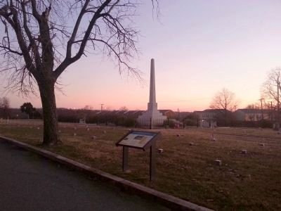
Oakwood Cemetery CWT Marker
GEOGRAPHIC SORT Title Sort Marker Number Sort Marker Number Sort N Marker Number Sort T Publication Order Sort Publication Order Sort A Erected Year Sort Most Viewed Sort Most Recent-Interest Sort Most Recently Changed Sort SEE FAQ #33 FOR DESCRIPTIONS
Near Oakwood Avenue at East Richmond Road.
On Meadow Road (County Route 156), on the right when traveling east.
On East Williamsburg Road (U.S. 60), on the left when traveling west. Reported permanently removed.
On East Williamsburg Road (Route 60) west of Rodes Avenue, on the left when traveling west.
On Grapevine Road, 0.3 miles south of Old Hanover Road, on the right when traveling south.
On Elko Road (County Route 156), on the right when traveling south on Elko Road. Reported missing.
On Farmers Circle Drive at New Market Road (Virginia Route 5), on the left when traveling north on Farmers Circle Drive.
Near Kingsland Road, 0.3 miles west of Deep Bottom Road, on the right when traveling west.
Near Kingsland Road, 0.3 miles west of Deep Bottom Road, on the right when traveling west.
Near Kingsland Road, 0.3 miles west of Deep Bottom Road, on the right when traveling west.
On New Market Road (Virginia Route 5) at Strath Road, on the right when traveling east on New Market Road.
On Elleber Sods Road (U.S. 250), on the right when traveling south.
On U.S. 250, on the left when traveling west. Reported permanently removed.
Near Highland Turnpike (U.S. 250) 1.5 miles east of Virginia Route 656, on the right when traveling east. Reported permanently removed.
On Highland Turnpike (U.S. 250) 1.5 miles east of Bullpasture River Road (Virginia Route 678), on the left when traveling west. Reported permanently removed.
Paid Advertisement
On Virginia Route 645 just north of Highland Turnpike (U.S. 250), on the right when traveling north. Reported permanently removed.
Near Bullpasture River Road (Virginia Route 678) 0.2 miles west of Highland Turnpike (U.S. 250), on the right when traveling west. Reported permanently removed.
On Virginia Route 645 just north of Highland Turnpike (U.S. 250), on the left when traveling north. Reported permanently removed.
On Highland Turnpike (U.S. 250) 1.5 miles east of Bullpasture River Road (Virginia Route 678), on the left when traveling north. Reported permanently removed.
On Bullpasture River Road (County Route 678) at Highland Turnpike (U.S. 250), on the right when traveling west on Bullpasture River Road. Reported permanently removed.
On West Main Street (U.S. 250) just east of Spruce Street, on the right when traveling east.
On High Street (U.S. 250), on the left when traveling west. Reported permanently removed.
On Oaklawn Boulevard (Virginia Route 36) at U.S. 295, on the right on Oaklawn Boulevard.
On Water Street at Pecan Avenue, on the right when traveling north on Water Street. Reported permanently removed.
On Appomattox Street at Cedar Lane, on the right when traveling north on Appomattox Street.
On Cedar Lane at Pecan Avenue, on the left when traveling north on Cedar Lane. Reported permanently removed.
On Pecan Avenue west of Prince Henry Avenue, on the left when traveling east. Reported permanently removed.
On Pelham Street at Prince Henry Avenue, on the right when traveling west on Pelham Street. Reported permanently removed.
On Eppes Street, on the right when traveling west.
On Brown Avenue north of Maplewood Avenue, on the right when traveling north. Reported permanently removed.
On Prince Henry Avenue at Maplewood Avenue, on the right when traveling north on Prince Henry Avenue. Reported permanently removed.
Paid Advertisement
On Prince Henry Avenue south of Pecan Avenue, on the right when traveling south. Reported permanently removed.
On Brown Avenue south of Pecan Avenue, on the right when traveling south.
On Water Street south of Pecan Avenue, on the right when traveling south. Reported permanently removed.
On Cedar Lane at Maplewood Avenue, on the right when traveling south on Cedar Lane. Reported permanently removed.
On Prince Henry Avenue at Maplewood Avenue, on the right when traveling north on Prince Henry Avenue. Reported permanently removed.
On Cedar Lane at Maplewood Avenue, on the right when traveling south on Cedar Lane. Reported permanently removed.
On Pecan Avenue, on the left when traveling east. Reported permanently removed.
Near Appomattox Street at Fort Street. Reported permanently removed.
Near Weston Lane, 0.2 miles west of North 21st Avenue, on the right when traveling west.
On Bank Street at Prince Henry Avenue, on the left when traveling west on Bank Street. Reported permanently removed.
On South Church Street (Business Virginia Route 10) 0.2 miles east of Jericho Road, on the left when traveling east. Reported missing.
Near Fort Boykin Trail (Virginia Route 705) at Mogarts Beach Road (Virginia Route 673), on the left when traveling north.
Near Talcott Terrace at Lawnes Neck Drive, on the right when traveling east. Reported missing.
Near Talcott Terrace at Lawnes Neck Drive, on the right when traveling east.
Near Benns Church Boulevard (Virginia Route 10) south of Casper Circle, on the right when traveling west.
On Penniman Road at Queens Creek Road, on the left when traveling north on Penniman Road.
Paid Advertisement
On Nelson Bridge Road (County Route 615) 0.9 miles north of River Road, on the right when traveling north.
On Seminary Road (Route 708) at Seminary Church Loop (Old U.S. 58), on the left when traveling west on Seminary Road.
On Moses Mill Road (Stono Lane) at Saunders Drive (Woods Creek Service Road), on the right when traveling north on Moses Mill Road (Stono Lane).
On East Washington Street, on the left when traveling east.
On John Mosby Highway (U.S. 50), on the right when traveling east.
On John Mosby Highway (Virginia Route 50) 0.1 miles west of Snickersville Turnpike (Route 734), on the right when traveling west.
On John Mosby Highway (U.S. 50), on the right when traveling east.
On John Mosby Highway at Watson Road, on the right on John Mosby Highway.
On Breaux Vinyard Lane, 0.2 miles east of Harpers Ferry Road (County Route 671), on the right when traveling east.
On Loudoun Street SW, on the right when traveling west.
On Tutt Lane (Route 740) west of Victory Lane, on the left when traveling west.
On Edward’s Ferry Road at Battlefield Parkway North East, on the left when traveling east on Edward’s Ferry Road. Reported damaged.
Near Fort Evans Road NE (Virginia Route 773) 0.1 miles west of Battlefield Parkway, on the right when traveling west.
On East Market Street (Business Highway 7) at North King Street (Business U.S. 15) on East Market Street.
Near Riverpoint Drive, on the left when traveling east.
On Old Waterford Road at North Street NW, on the right when traveling south on Old Waterford Road.
Paid Advertisement
On North King Street (Business U.S. 15) at North Street, on the right when traveling south on North King Street.
On Loudoun Street SW, on the right when traveling west.
On Market Street (Business State Highway 7) at King Street (Business U.S. 15), on the right when traveling west on Market Street. Reported permanently removed.
On Gleedsville Road (County Road 650) at Stone Fox Court, on the right when traveling north on Gleedsville Road.
On Tutt Lane (Virginia Route 740) west of Victory Lane, on the left when traveling west.
Near Oatlands Plantation Lane.
On Southern Planter Lane, on the right when traveling south. Reported missing.
On Oatlands Plantation Lane, 0.3 miles south of James Monroe Highway (U.S. 13), on the right when traveling south.
On East Broad Way (County Route 673) at South Loudoun Street, on the right when traveling east on East Broad Way.
On Berlin Pike (County Route 287) at Broadway (County Route 673) on Berlin Pike. Reported permanently removed.
On Town Square (Virginia Route 287) just west of West Broad Way, on the left when traveling west.
Near Hibler Road (Virginia Route 656) east of Harrison Hill Lane, on the right when traveling east.
Near Hibler Road (Virginia Route 656) east of Harrison Hill Lane, on the right when traveling east.
On The Plains Road (County Route 626), on the right when traveling south.
On North Madison Street at West Marshall Street, on the right when traveling north on North Madison Street.
On East Federal Street east of Liberty Street, on the right when traveling east.
Paid Advertisement
Near John Mosby Highway (U.S. 50) west of Zulla Road (Virginia Route 709), on the right when traveling east.
Near John Mosby Highway (U.S. 50) west of Zulla Road (Virginia Route 709), on the left when traveling west.
On Snickersville Turnpike (County Route 734) at JEB Stuart Road (County Route 630), on the right when traveling north on Snickersville Turnpike.
On North Maple Avenue north of East Main Street (Business Virginia Route 7), on the right when traveling east.
On East Main Street (Virginia Route 7) at North Hatcher Avenue on East Main Street.
On Harry Byrd Highway (State Highway 7), on the right when traveling west. Reported missing.
Near Old Vestal's Gap Road.
On Lovettsville Road (County Road 672) west of James Monroe Highway (U.S. 15), on the right when traveling west.
On Unison Road (County Route 630), on the right when traveling east.
On Lemmons Bottom Road north of John S. Bosby Highway (U.S. 50), on the right when traveling north. Reported permanently removed.
On Patrick Street at High Street (County Route 665), on the right when traveling west on Patrick Street. Reported permanently removed.
On Patrick Week (Virginia Route 783) at High Street (Virginia Route 665), on the right when traveling west on Patrick Week.
On Oakland Road (County Route 613), on the right when traveling north.
On Ellisville Drive (County Route 669) at Oakland Road (County Route 613), on the right when traveling north on Ellisville Drive.
On Louisa Road (U.S. 33) at Danne Road (County Route 682), on the right when traveling west on Louisa Road.
On Louisa Road (U.S. 33) at Danne Road (County Route 682), on the right when traveling west on Louisa Road.
Paid Advertisement
On West Street (County Route 666), on the right when traveling west.
On Ellisville Drive (County Route 669), on the right when traveling south.
On West Main Street (U.S. 33) at Elm Avenue, on the right when traveling east on West Main Street.
On Oakland Road (County Route 613), on the right when traveling north.
On West Street (County Route 666), on the right when traveling west.
776 entries matched your criteria. Entries 301 through 400 are listed above.
⊲ Previous 100 —
Next 100 ⊳