Ventura County Historical Landmarks Historical Markers
The Ventura County Historic Landmarks & Points of Interest consist of buildings, sites, and neighborhoods designated by Ventura County, California, Cultural Heritage Board as historic landmarks and points of interest.
Near Camarillo Ranch Road north of Mission Oaks Boulevard.
Across Mission Oaks Boulevard, next to the 101 Freeway, remains part of a grove of Eucalyptus trees that once lined both sides of the old two-lane El Camino Real. In 1892, Adolfo Camarillo planted 650 of these trees, which stretched from Pleasant . . . — — Map (db m130636) HM
Near Camarillo Ranch Road north of Mission Oaks Boulevard, on the right when traveling north.
This grand three-story, 15-room home was built by Adolfo Camarillo in the Queen Ann Victorian style, using the plans of architects Herman Anlauf and Franklin Ward. The home features seven bedrooms, a grand staircase, a tower bay, a walk-in wooden . . . — — Map (db m129517) HM
On Central Avenue at Main Street, on the right when traveling north on Central Avenue.
This building was constructed in 1917 to house the Fillmore State Bank, which had been founded in 1905 by Judge Felix Ewing and John Carne. In 1927 it became the Bank of Italy; the name was changed in 1930 to Bank of America. In 1965 the building . . . — — Map (db m77889) HM
On Main Street, 0.1 miles east of Central Avenue, on the right when traveling east.
• By 1919 Rancho Sespe had three bachelor quarters: The Japanese "Ranch House" built in
1909, Bunkhouse No. 1 (built in 1911) and Bunk House No. 2 (Built in 1919).
• The "Ranch House" was some distance away from the main headquarters . . . — — Map (db m217988) HM
On Main Street, 0.2 miles east of Central Avenue, on the right when traveling east.
The Southern Pacific Depot was built in 1887 during the Southern California land boom of that decade. It was saved from demolition and moved to its present site in 1974 to become the Fillmore Historical Museum. This was done through the efforts of . . . — — Map (db m132748) HM
On Bard Street west of Saratoga Street, on the left when traveling west.
“The Artists Barn” was established in 1936 by Mr. Lawrence Hinckley. The converted old redwood barn served for many years as an art center for Ventura County and drew national recognition. The barn and pepper tree date back to the late . . . — — Map (db m135704) HM
On Walnut Street at Charles Street, on the right when traveling north on Walnut Street.
This church is a unique combination of two historic buildings, the Epworth and the Somis churches.
Retired Methodist ministers established the Epworth Colony in what is now the Fairview district of Moorpark. A small chapel was built in 1894 . . . — — Map (db m131705) HM
On Santa Rosa Road, 0.6 miles west of Moorpark Road, on the left when traveling west.
Santa Rosa School Site and School Bell
The first Santa Rosa School was built
and the school bell installed in 1912
by local farmers, among whom were
members of the Norwegian Colony in
Conejo Valley. A new school was built
in . . . — — Map (db m180259) HM
Near North Ventu Park Road, on the right when traveling south.
"The hotel was built by James Hammell as the Grand Union Hotel in 1876 and was often called the "Conejo" or "Big" Hotel. In 1885, the site was purchased by Cecil Haigh. In 1965, his grandson, H. Allen Hays, donated 4 acres and the hotel to the . . . — — Map (db m78003) HM
On Matilija Hot Springs Road west of California Route 33, on the left when traveling west.
Matilija Hot Springs was developed as a health spa and
vacation resort by J.W.Wilcox in 1871. In 1873 cabins were
added and a hotel built. The resort was destroyed by
the floods of 1884, but rebuilt in 1885 with a bath house
and other . . . — — Map (db m167495) HM
On Ojai Avenue at Signal Street, on the right when traveling east on Ojai Avenue.
The Ojai Post Office Tower and Portico,
completed in 1917, provide a
scenic focal point for the downtown area.
Architects Frank Mead and Richard Requa
modeled the tower after the
Christopher Columbus Cathedral
in Havana, Cuba, with . . . — — Map (db m154419) HM
The original Bowl was built in Edward Drummond Libbey's Civic Center Park in phases from 1952 to 1957 by a community effort led by the Ojai Music Festival.
The shell was designed by architects Austen Pierpont of Ojai and Roy C. Wilson of Santa . . . — — Map (db m154425) HM
On East 5th Street, 0.1 miles east of Oxnard Boulevard, on the right when traveling east.
The American Beet Sugar Factory was built on a 100-acre site between 5th Street and Wooley Road in 1898 at a cost
of $2,000,000 by sugar industrialists Henry, James, Robert and
Benjamin Oxnard. It was the second largest sugar beet factory in
the . . . — — Map (db m172231) HM
On Garfield Avenue north of Colonia Road, on the right when traveling north.
Cesar E. Chavez was born in Yuma,
Arizona, on March 31, 1927. His parents
Librado and Juana Chavez came to
Oxnard to work in the walnut orchards
in 1938, 1939 and 1940. During their 1939 stay
the family lived in a storage building at
this . . . — — Map (db m146945) HM
Near A Street south of 7th Street, on the right when traveling south.
Original - Earlier Names: (1) Christian Church. (2) First Church of Christ Scientist.
Original - Earlier Locations: (1) Corner of C and 6th Streets. (2) Corner of D and 2nd Streets.
Construction Date: Summer 1902.
Architect & Builder: E. . . . — — Map (db m194104) HM
Near A Street south of 7th Street, on the right when traveling south.
Original Owner: David Tod Perkins. Original Location: 464 W. Pleasant Valley Road. Construction Date: Ca. 1887. Builder: Jens Rasmussen.
The History
David Tod Perkins was the son of a prominent
Ohio family that included a . . . — — Map (db m194101) HM
Near B Street south of 7th Street, on the left when traveling south.
Original Owner: Justin and Frances Petit. Original Location: 1900 East Wooley Road. Construction Date: Ca. 1896. Architect: Herman Anlauf.
The History
The Petit family emigrated from France to America
in 1853 when baby Justin . . . — — Map (db m194066) HM
On Pacific Coast Highway (California Route 1) at Mugu Canyon Rest Area, on the left when traveling north on Pacific Coast Highway.
Chumash seafarers were so comfortable on the ocean that elder Kitsepawit once called the tomol (plank canoe) “the house of the sea.” Shipbuilders crafted the tomol by splitting driftwood, sewing planks with cordage, and caulking with . . . — — Map (db m154652) HM
Near Gottfried Place north of Cesar Chavez Drive, on the left when traveling north.
Built in the 1870's by Gottfried Maulhardt
who was on the building committee for the
Santa Clara Chapel along with his brothers
Jacob and Anton plus Dominick McGrath,
Thomas Cloyne & Christian Borchard.
Gottfried grew 250 vines of the . . . — — Map (db m146638) HM
On South C Street near 5th Street, on the left when traveling south.
The pagoda was built in 1910 to house the pump which supplied water for irrigating the park. It was designed by architect Alfred J. Priest and built by Thomas H. Carroll, contractor. In 1911 the roof was raised to provide room for the band platform. . . . — — Map (db m120957) HM
On State Highway 126, 2 miles east of Piru, on the right when traveling east.
Rancho Camulos has been designated a National Historic Landmark.
This residential complex possesses national
significance in commemorating the history of the
United States of America.
Ygnacio del Valle established Rancho Camulos in 1853, on . . . — — Map (db m154495) HM
On Park Street, 0.2 miles north of Center Street, on the left when traveling north.
Built 1886-1890 by David Caleb Cook.
Destroyed by fire February 18, 1981.
Rebuilt 1981-1983 by Ruth and Scott Newhall,
with the skills of the following artists and artisans:
John L. Schleimer, J & J Construction Co., Contractor. . . . — — Map (db m170370) HM
Berylwood, The Thomas R. Bard Estate, 1912
The Officers Club of the Naval Construction Battalion Center
was originally the home of the honorable Thomas R. Bard,
U.S. Senator (California, 1900-1905) and his family. This was
the . . . — — Map (db m215216) HM
On Ventura Road at Park Avenue, on the right when traveling south on Ventura Road.
Site of Sen. Thomas R. Bard’s first home. A memorial
plot was built by the Bard family and dedicated in
1958. Now owned by the United States government
with an easement to the city of Port Hueneme for
the purpose of maintaining a memorial to the . . . — — Map (db m193908) HM
On South Surfside Drive south of Port Hueneme Road, on the right when traveling south.
W. B. Moranda Park was constructed over the former Hueneme Slough, or lagoon. High tides created this 8-acre body of water surrounded by cattails (tules) making it a haven for water fowl. The Ventura County Railroad crossed the slough on a trestle . . . — — Map (db m136194) HM
Near Surfside Drive, 0.6 miles west of Market Street, on the left when traveling west.
As early as 1857, the need for a lighthouse at Point Hueneme to mark the eastern Santa Barbara Channel entrance was recognized. In March 1873 Congress appropriated funds for a light station and a 60-acre lighthouse reservation at Point Hueneme. . . . — — Map (db m155775) HM
On Scott Street at Market Street, on the right when traveling west on Scott Street.
Women's Improvement Club has been placed on the National Register of Historic Places by the United States Department of the Interior. — — Map (db m193824) HM
On Main Street at 10th Street, on the right when traveling west on Main Street.
Birthplace of Union Oil Company of California. Founded October 17, 1890. Presented by the City of Santa Paula, California, to Union Oil Company of California, in commemoration of the company's 50 years of service to the West, August Twenty-Four, . . . — — Map (db m154493) HM
On Saticoy Street at 11th Street, on the right when traveling west on Saticoy Street.
1925 - Canyon School was built.
Built especially for Spanish-speaking
children to meet their language needs.
Parents were offered classes in citizenship,
health, and homemaking.
Originally, there were eight classrooms. . . . — — Map (db m184851) HM
Near South 10th Street (California Route 150) at E. Harvard Boulevard. Reported missing.
Jose Angel Diaz and Josepha de la Torre came to Santa Paula from Mexico with their parents. They met in 1916 while working at Limoneira Packing House, married in 1919 and started the first cafe at their home in 1935. In 1936 they moved into a . . . — — Map (db m120829) HM
On Telegraph Road west of Briggs Road, on the left when traveling west.
This home was the culmination of George
Washington Faulkner’s dream, expressed to
his bride in 1876: "We will have to begin
at the foot of the ladder and grow up with
the country, but I think that in a few years
we can have a beautiful home if . . . — — Map (db m131410) HM
On Railroad Avenue at 9th Street, on the right when traveling west on Railroad Avenue.
This church was built in 1900 by
contributions from the members of
the congregation. The Reverend Mr.
James F. Stewart chaired the committee
of church members who supervised the
building of the church, and raising the
funds necessary for . . . — — Map (db m175578) HM
On Mill Street at Santa Barbara Street, on the right when traveling south on Mill Street.
Glen Tavern Inn, built 1911.
Presented by
Aquila Chase chapter,
National Society Colonial Dames XVII Century,
12 October 2014.
The Glen Tavern Inn, built in 1911,
has been placed on the
National Register
of Historic Places
by . . . — — Map (db m175684) HM
On 4th Street north of Harvard Boulevard, on the right when traveling north.
Federal Works Agency,
Public Works
Administration. John M. Carmody, Federal Works Administrator.
Franklin D. Roosevelt,
President of the United States. Isbell School,
1939. — — Map (db m184889) HM
Near Pleasant Street at Mill Street, on the right when traveling west.
North Grammar School was built
in 1910 on land given by Mrs. Alice
Stowell McKevett.
On May 15, 1927, the PTA and Pioneer
Section of the Ebell Club rededicated
North Grammar School as McKevett
School in honor of its pioneer donor.
Local . . . — — Map (db m184881) HM
On East Telegraph Road (California Route 126), on the right when traveling east.
The Santa Clara School District was formed in 1879 when farmers in the area wanted a public school for their children.
Members of the first Board of Trustees were Mathew Atmore, Ruben Hall and C.H. Chittenden. The first schoolhouse was built in . . . — — Map (db m125568) HM
On East Telegraph Road (California Route 126) 1.6 miles east of California Route 150, on the right when traveling east.
The west portion of this house, which was built in the 1870s, is the original Tanner Home. Albert Miles Tanner was a member of the Mormon Battalion at the time of the War with Mexico. He opened the first hotel in Sacramento with Sam Brannon. Later . . . — — Map (db m131741) HM
On 10th Street at Santa Barbara Street, on the left when traveling north on 10th Street.
Prefabricated in Southern Pacific's
Sacramento shops, shipped in sections
by rail, and assembled on this site;
the depot opened for business in
1887. The second story served as
living quarters for the station agent and
family. . . . — — Map (db m175580) HM
On South 7th Street south of Main Street, on the left when traveling south.
The Ebell Club of Santa Paula was organized in 1913. It was the ninth chapter in California. In 1917, Alice Stowell McKevett donated land for Ebell Park and erected the first half of the building in memory of her husband, Charles M. McKevett. The . . . — — Map (db m120828) HM
On Ojai Road (California Route 150) at Royal Oaks Place, on the left when traveling north on Ojai Road.
Site of the W. L. Hardison Estate, established in 1884 by Wallace Libbey
Hardison with his wife Clara McDonald. Hardison, born in Maine in 1850, was
a Representative in the 104th Pennsylvania Legislature before coming to
Santa Paula in 1883 with . . . — — Map (db m175487) HM
On Main Street at Davis Street, on the left when traveling west on Main Street.
This is the site of the first meeting
of the Santa Paula Oddfellows lodge,
April 26 1884. The original hall was
destroyed by fire in 1903. The present
building with the clock tower was erected
in 1905. Community donations made it possible
to . . . — — Map (db m175682) HM
Near Cosmos Avenue, 0.1 miles south of Telephone Road.
Ventura County is within the historic territory of the Ventureño Chumash. The Chumash village of Sa’aqtik’oy, from which the Saticoy area takes its name, was located near this site and was first recorded in the diaries of Juan Rodriguez Cabrillo . . . — — Map (db m184242) HM
Near Strathearn Place, 0.2 miles west of Madera Road.
This is the site of the headquarters of the Spanish Rancho San Jose de Nuestra Senora de Altagarcia y Simi. The name derives from "Shimiji," the name of the Chumash village here before the Spanish. At 113,000 acres, Rancho Simi was one of the . . . — — Map (db m167458) HM
On Cochran Street west of Fig Street, on the right when traveling west.
Grandma Prisbrey's Bottle Village
This fantastic assemblage is one of California's remarkable Twentieth Century Folk Art Environments. In 1956, Tressa Prisbrey, then nearly 60 years old, started building a fanciful "village" of shrines, . . . — — Map (db m149173) HM
On Heritage Oak Court, 0.1 miles west of Tapo Canyon Road, in the median.
The Heritage Oak that stood on this site for more than 400 years was witness to the 4 historical periods of Simi Valley. From the Chumash Indians, to the largest land grant ever made to the Pico family in the Spanish period, through the pioneer . . . — — Map (db m132651) HM
On Katherine Road at Kuehner Drive, on the right when traveling west on Katherine Road.
Built by the Southern Pacific Railroad in 1903 at Los Angeles Avenue and Tapo Street. Moved to its present site in 1975. Designated by the Ventura County Heritage Board in 1976 as County Historical Landmark 29. — — Map (db m117586) HM
This town site at Corriganville had many names in Hollywood including Dodge City, Mineral City, Tombstone, and Lone Ranger Ranch. Most visitors knew it as Silvertown. Whatever the name, people came by the busloads to be entertained by the Wild West . . . — — Map (db m154424) HM
Near Strathearn Place, 0.2 miles west of Madera Road, on the right when traveling west.
The Simi Adobe was headquarters for the Spanish Colonial Land Grant named San Jose de Nuestra Senora de Altagracia y Simi. Santiago Pico was the original grantee in 1795, followed by three of his sons, Francisco Javier, Miguel and Patricio, to whom . . . — — Map (db m143273) HM
On School Street just west of Deodora Street, on the left when traveling west.
These are Simi Valley's only school
buildings of any significant age.
Simi School District was formed in 1889,
and school was held in one of the
colony houses, while the new building
was built and furnished for $3000.
In 1902, . . . — — Map (db m172223) HM
Near Strathearn Place, 0.2 miles west of Madera Road.
Community-minded citizens of Simi Valley raised the
money for the land, then asked the Ventura County
Library system to build this small building. There had
been numerous county branches here and there, using
a spare room in a church or . . . — — Map (db m173110) HM
Near Strathearn Place, 0.2 miles west of Madera Road.
These barns were built in the 1940s on the 5000-acre
cattle ranch in the southwest corner of Simi Valley.
The ranch had been known by many names through
the years. It was Cañada Verde during Spanish Rancho
times, then shortened to the Verde. . . . — — Map (db m173111) HM
On North Street west of West Street, on the left when traveling west.
The Somis School building is located on the former site of the Somis Methodist Church.
It was built in 1924 to replace the older school building which became the Somis Thursday Clubhouse.
Originally the school had only three classrooms. . . . — — Map (db m163459) HM
On Pleasant Way at Oakview Drive, on the right when traveling east on Pleasant Way.
The Crowley house was built in 1910 for Frank and Mae Crowley. In the 1920s, the home served as the sales office and dining venue for
prospective home buyers
interested in purchasing a home
in the new development of
Thousand Oaks. E.B. . . . — — Map (db m134189) HM
On Thousand Oaks Boulevard at The Lakes Drive, on the right when traveling east on Thousand Oaks Boulevard.
On this site Louis Goebel opened one of Southern California’s most popular tourists attractions. In 1925, Goebel purchased five lots for $50 along old Ventura Boulevard, which later became Thousand Oaks Boulevard. This land had formerly belonged to . . . — — Map (db m138682) HM
Near Lang Ranch Parkway, 0.5 miles east of Westlake Boulevard, on the right when traveling east.
Dating as far back as 12,000 years ago until the late 1800’s, Chumash people had established many villages and seasonal encampments in this area due to territorial and ritual privileges and the abundant source of food and water bestowed upon the . . . — — Map (db m154420) HM
On Regent Avenue at Faculty Street, on the left when traveling north on Regent Avenue.
When the college opened in 1961, the chicken coops located on the Pederson ranch were converted for campus use. F Building housed the campus coffee shop, which doubled as the cafeteria, and a full soda fountain, E Building served as the library; D . . . — — Map (db m154417) HM
On Greenmeadow Avenue, 0.5 miles west of Moorpark Road, on the right when traveling west.
This house was built in 1931 by Dr.
Edwin Janss, Sr. from designs by his wife
Florence Janss. It was the weekend
retreat of the Janss family, the base of
their Conejo Valley ranch, founded in 1910,
and the family home of Edwin Janss, Jr. . . . — — Map (db m143287) HM
On Poli Street at North California Street, on the right when traveling west on Poli Street.
This imposing building was designed by Albert C. Martin and built in 1912 as the Ventura County Court House. It is an outstanding example of neo-classic architecture, considered the proper style for public buildings of the early 20th century. The . . . — — Map (db m154494) HM
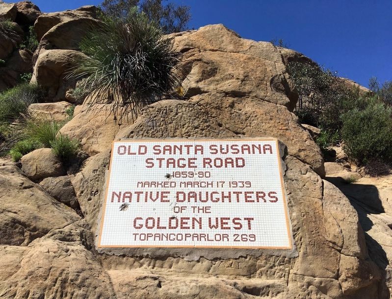
On Cañada Larga Road east of Highway 33, on the right when traveling east.
A visible section of the mission aqueduct still exists just east of Highway 33 on Cañada Larga Road. It is one of the few remaining parts of a seven-mile-long system that delivered water from San Antonio Creek to El Caballo filtration plant on the . . . — — Map (db m143278) HM
On North Ventura Avenue, 0.5 miles north of Cañada Larga Road, on the right when traveling north.
Santa Gertrudis Asistencia (chapel) was originally located about 500 feet north. Its location is now covered by the freeway. This chapel served the Indians in the early days.
Marked 1970. Replaced 1986. — — Map (db m143330) HM