140 entries match your criteria. The first 100 are listed. ⊳
Former U.S. Presidents: #36 Lyndon B. Johnson Historical Markers
By Mark Hilton, March 25, 2015
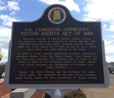
U.S. Congress Approves Voting Rights Act of 1965 Marker (Side 2)
| 1 ► Alabama, Dallas County, Selma — 'Bloody Sunday' Attack at Edmund Pettus Bridge / U.S. Congress Approves Voting Rights Act of 1965 |
| On Broad Street (Business U.S. 80) at Water Avenue, on the right when traveling north on Broad Street. Reported permanently removed. | |||
| 2 ► Alabama, Escambia County, Flomaton — Flomaton, Alabama — |
| On Sidney E Manning Blvd (U.S. 29) at Houston Street, on the right when traveling north on Sidney E Manning Blvd. | |||
| 3 ► Alabama, Lowndes County, White Hall — Marchers, Supporters, Hecklers — Selma to Montgomery National Historic Trail — |
| Near U.S. 80 west of White Hall Road. | |||
| 4 ► Alabama, Montgomery County, Montgomery — 9 — Judge Frank M. Johnson: Judicial Fairness in the Age of Segregation — Molton and Montgomery Streets — Selma to Montgomery National Historic Trail — |
| On Montgomery Street at Catoma Street, on the right when traveling south on Montgomery Street. | |||
| 5 ► Alabama, Montgomery County, Montgomery — 11 — Thousands Protest at the Seat of Government — Dexter Avenue — Selma to Montgomery National Historic Trail — |
| On Dexter Avenue at South Bainbridge Street, on the right when traveling east on Dexter Avenue. | |||
| 6 ► Arkansas, Benton County, Bella Vista — United States Commanders in Chief — |
| 7 ► Delaware, New Castle County, Wilmington, Swedes Landing — The Park — |
| Near East 7th Street just east of Swedes Landing Road, on the right when traveling east. | |||
| 8 ► District of Columbia, Washington, Northeast Washington, Brookland — Robert Clifton Weaver Residence Site — 3519 14th Street, NE — African American Heritage Trail, Washington DC — |
| On 14th Street Northeast north of Monroe Street Northeast. | |||
| 9 ► District of Columbia, Washington, Northwest Washington, Adams Morgan — 5 — Ambassadors of Faith — Roads to Diversity — Adams Morgan Heritage Trail — |
| On 16th Street, NW just south of Harvard Street, NW, on the right when traveling south. | |||
| 10 ► District of Columbia, Washington, Northwest Washington, American University Park — 15 — For the Children — Top of the Town — Tenleytown Heritage Trail — |
| On Nebraska Avenue Northwest at Van Ness Street Northwest, on the right when traveling south on Nebraska Avenue Northwest. | |||
| 11 ► District of Columbia, Washington, Northwest Washington, Downtown — Executive Office Building — |
| On Pennsylvania Avenue Northwest at 17th Street Northwest, on the right when traveling east on Pennsylvania Avenue Northwest. | |||
| 12 ► District of Columbia, Washington, Northwest Washington, LeDroit Park — 2 — T Street Elites — Worthy Ambition — LeDroit Park/Bloomingdale Heritage Trail — |
| On T Street Northwest west of 4th Street Northwest when traveling west. | |||
| 13 ► District of Columbia, Washington, Northwest Washington, Logan Circle — Belford V. Lawson and Marjorie M. Lawson Residence — 8 Logan Circle, NW — African American Heritage Trail, Washington DC — |
| On Logan Circle Northwest west of 13th Street Northwest when traveling west. | |||
| 14 ► District of Columbia, Washington, Northwest Washington, Logan Circle — 13 — The Presidents' Church — A Fitting Tribute — Logan Circle Heritage Trail |
| On 14th Street Northwest at Thomas Circle Northwest when traveling south on 14th Street Northwest. Reported damaged. | |||
| 15 ► District of Columbia, Washington, Northwest Washington, Pleasant Plains — 11 — The Lake So Blue — Lift Every Voice — Georgia Ave./Pleasant Plains Heritage Trail — |
| On 6th Street Northwest at Fairmont Street Northwest on 6th Street Northwest. | |||
| 16 ► District of Columbia, Washington, Northwest Washington, Sheridan-Kalorama — Robert Emmet: Irish Patriot — Rock Creek Park — National Park Service, U.S. Department of the Interior — |
| On 24th Street Northwest north of Massachusetts Ave Northwest, on the left when traveling north. | |||
| 17 ► District of Columbia, Washington, Southeast Washington, Anacostia — Thurgood Marshall — |
| Near Erie Street Southeast east of 18th Place Southeast, on the right when traveling east. | |||
| 18 ► District of Columbia, Washington, Southwest Washington, Columbia Island — "Where flowers bloom, so does hope" — Claudia Alta Taylor “Lady Bird” Johnson — Lady Bird Johnson Park - George Washington Memorial Parkway — |
| On Boundary Channel Drive, on the right when traveling north. | |||
| 19 ► District of Columbia, Washington, Southwest Washington, Columbia Island — Architect of the Great Society — George Washington Memorial Parkway — Lyndon Baines Johnson Memorial Grove — |
| On Boundary Channel Drive, on the right when traveling north. | |||
| 20 ► District of Columbia, Washington, Southwest Washington, Columbia Island — First Bloom — Lady Bird Johnson Park — George Washington Memorial Parkway |
| Near George Washington Memorial Parkway north of Boundary Channel Drive, on the right when traveling east. Reported missing. | |||
| 21 ► District of Columbia, Washington, Southwest Washington, Columbia Island — The Memorial Grove — A Living Legacy — Lady Bird Johnson Park — |
| On George Washington Memorial Parkway, 0.5 miles South Washington Boulevard, on the right when traveling south. | |||
| 22 ► District of Columbia, Washington, Southwest Washington, Columbia Island — Tomorrow is ours to win or lose — Lyndon Baines Johnson Memorial Grove on the Potomac — National Park Service, U.S. Department of the Interior |
| On George Washington Memorial Parkway, 0.5 miles east of South Washington Boulevard. Reported permanently removed. | |||
| 23 ► District of Columbia, Washington, Southwest Washington, Southwest Waterfront — Can you identify these famous Civil Rights leaders? — All four lived in this Southwest DC neighborhood! |
| On 7th Street Southwest south of G Street Southwest, on the right when traveling north. Reported unreadable. | |||
| 24 ► Florida, Brevard County, Mims — Thurgood Marshall — Harry T. & Harriette V. Moore Memorial Park — |
| Near Freedom Avenue, 0.3 miles south of Parker Street, on the left when traveling south. | |||
| 25 ► Florida, Citrus County, Crystal River — Withlacoochee Bay Trail — Marjorie Harris Carr Cross Florida Greenway — |
| On Withlacoochee Bay Trail, 4.6 miles west of North Suncoast Boulevard (U.S. 19). | |||
| 26 ► Florida, Hillsborough County, East Lake-Orient Park — United States occupation of the Dominican Republic (1965-1966) — Hillsborough County Veterans Memorial Park — |
| Near U.S. 301, 0.2 miles south of East Dr. Martin Luther King Jr. Boulevard, on the right when traveling south. | |||
| 27 ► Florida, Marion County, Ocala — Canal Building — Historic Florida Barge Canal Trail — |
| Near Southeast 80th Street (County Road 328) at South Pine Avenue (U.S. 441), on the right when traveling east. | |||
| 28 ► Florida, Miami-Dade County, Florida City — F-739 — Operation Pedro Pan — Operación Pedro Pan — |
| On NW 14th Street at NW 2nd Avenue, on the right when traveling east on NW 14th Street. | |||
| 29 ► Florida, Miami-Dade County, Homestead — The Edge of "Progress" / Al Margen del "Progreso" — |
| Near Southwest 328th Street, 2.8 miles east of Southwest 117th Avenue (Colonial Road) when traveling east. | |||
| 30 ► Florida, Okaloosa County, Hurlburt Field — Lieutenant Colonel Joe Madison Jackson — 311th Air Commando Squadron — |
| Near Oneal Avenue. | |||
| 31 ► Florida, Okaloosa County, Hurlburt Field — Major Bernard Francis Fisher — 1st Air Commando Squadron — |
| Near Oneal Avenue. | |||
| 32 ► Florida, Putnam County, Crescent City — F-564 — Asa Philip Randolph — |
| On Eucaliptus Avenue at Cedar Street, on the right when traveling west on Eucaliptus Avenue. | |||
| 33 ► Florida, Putnam County, Palatka — Buckman Lock North / Buckman Lock South — Marjorie Harris Carr Cross Florida Greenway — |
| Near Buckman Lock Road, 0.9 miles south of Florida Route 19. | |||
| 34 ► Florida, Putnam County, Palatka — F-122 — Cross Florida Barge Canal |
| On State Road 19 at Boys Ranch Road, on the right when traveling north on State Road 19. Reported missing. | |||
| 35 ► Florida, Putnam County, Palatka — F-123 — Cross Florida Barge Canal Memorial — |
| On Martinez Circle, 0.2 miles north of Boys Ranch Roadd when traveling north. | |||
| 36 ► Florida, Seminole County, Sanford — Mount Vernon Grove — Featured Tree — Mount Vernon Red Maple — |
| Near West 7th Street just west of Myrtle Avenue, on the right when traveling west. | |||
| 37 ► Florida, Seminole County, Sanford — Ponce de León Grove — Featured Tree — Ponce De León Live Oak — |
| Near Myrtle Avenue just north of West 7th Street, on the left when traveling north. | |||
| 38 ► Florida, Seminole County, Sanford — Vietnam War — 1954-1975 — |
| On Seminole Boulevard north of North Park Avenue, on the right when traveling west. | |||
| 39 ► Florida, St. Johns County, St. Augustine, Historic District — Andrew Young Crossing — Peaceful Protest for Civil Rights — |
| Near King Street (Business U.S. 1) at St George Street, on the left when traveling east. | |||
| 40 ► Georgia, Baldwin County, Milledgeville — Carl Vinson • Mary Green Vinson — Nov.18, 1883 - June 1, 1981 Sept. 19, 1887 - Nov. 16, 1950 — |
| Near S. Liberty Street continued, on the left when traveling south. | |||
| 41 ► Illinois, Kane County, Geneva — Vietnam — (1964-1975 U.S. Involvement) — |
| 42 ► Iowa, Cherokee County, Cherokee — Cherokee County Freedom Rock Veterans Memorial — |
| On W Main St at N 6th St on W Main St. | |||
| 43 ► Kentucky, Logan County, Russellville — 1960 — Civil Rights Activist Author / Alice Allison Dunnigan 1906-1983 — |
| On South Main Street at East 4th Street (Kentucky Route 3519), on the left when traveling north on South Main Street. | |||
| 44 ► Kentucky, Union County, Morganfield — 1844 — Earle C. Clements — (1896-1985) — |
| On East Main Street (Kentucky Route 56) at Park Street, on the left when traveling east on East Main Street. | |||
| 45 ► Louisiana, Ascension Parish, Gonzales — The Vietnam War — 1954-1975 — |
| Near South Irma Boulevard, 0.3 miles north of East Worthey Street, on the right when traveling north. | |||
| 46 ► Louisiana, Orleans Parish, New Orleans, Central Business District — Superdome Vietnam Wall — |
| Near Sugar Bowl Drive near Poydras Street. | |||
| 47 ► Louisiana, Orleans Parish, New Orleans, French Quarter — My Bourbon Home — |
| On Bourbon Street. | |||
| 48 ► Maryland, Anne Arundel County, Annapolis, Naval Academy — Evoking Our Naval Heritage Past — Sailing Confidently Into The Future — |
| Near Taylor Avenue (Maryland Route 435) north of Melrose Street, on the right when traveling south. | |||
| 49 ► Maryland, Anne Arundel County, Annapolis, Parole — 6c — How Parole Named Its Streets — Parole Heritage Tour — |
| Near West Street (Maryland Route 450) west of Chinquapin Round Road, on the right when traveling east. | |||
| 50 ► Maryland, Baltimore, Upton — Courting Justice — Pennsylvania Avenue Heritage Trail — |
| On Division Street at West Lanvale Street on Division Street. | |||
| 51 ► Maryland, Frederick County, Myersville — The Bill Pate Portal |
| On the West Welcome Center and Rest Area (Interstate 70) west of Exit 42 (Maryland Route 17). Reported permanently removed. | |||
| 52 ► Maryland, Frederick County, Thurmont — Harriet Chapel — Circa 1828 — |
| Near Catoctin Furnace Road (Maryland Route 806) north of Catoctin Hollow Road. | |||
| 53 ► Maryland, Prince George's County, Fort Washington, National Harbor — Working to Improve the River — |
| Near Capital Beltway (Interstate 95) west of National Harbor Boulevard, on the right when traveling east. | |||
| 54 ► Maryland, Worcester County, Ocean City — Smaller Conflicts After WWII — |
| On 24th Street just east of Philadelphia Avenue (Maryland Route 528), on the right when traveling east. | |||
| 55 ► Michigan, Ingham County, Lansing — E. Genevieve Gillette 1898-1986 — Athletics and Recreation — |
| Near South Washington Square, on the right when traveling north. | |||
| 56 ► Michigan, Oakland County, White Lake charter Township, White Lake Township — Genevieve Gillette — and the Treasures of Nature — |
| Near Haven Road, 0.1 miles south of Highland Road (Michigan Highway 59), on the left when traveling south. | |||
| 57 ► Minnesota, Hennepin County, Minneapolis, Hiawatha — President Lyndon B. Johnson — |
| Near South Minnehaha Park Drive near Godfrey Road. | |||
| 58 ► Mississippi, Coahoma County, Clarksdale — 16 — Aaron Henry — Mississippi Freedom Trail — |
| On Martin Luther King Boulevard at Ashton Alley, on the right when traveling west on Martin Luther King Boulevard. | |||
| 59 ► Mississippi, Hinds County, Jackson — 2 — Medgar Evers Home — Mississippi Freedom Trail — |
| On Margaret W Alexander Drive east of Missouri Street, on the left when traveling east. | |||
| 60 ► Mississippi, Pike County, McComb — 15 — C.C. Bryant — Mississippi Freedom Trail — |
| On C.C. Bryant Drive near Adams Avenue. | |||
| 61 ► Nevada, Churchill County, Fallon — 201 — Wonder — Historic Mining Camp — 1906 - 1919 |
| On U.S. 50 at milepost 61.5, on the right when traveling west. Reported missing. | |||
| 62 ► New York, Essex County, Newcomb — Theodore Roosevelt — |
| On Santanoni Drive at New York State Route 28N, on the left when traveling north on Santanoni Drive. | |||
| 63 ► New York, Orange County, West Point — Twentieth Century Wars — |
| On Thayer Road at Brewerton Road on Thayer Road. | |||
| 64 ► New York, Queens County, Queens, Corona — New York Worlds Fair — 1939 - 1940 1964 - 1965 — New Amsterdam Entrance — |
| On Shea Road at Calvert Circle when traveling south on Shea Road. | |||
| 65 ► Ohio, Athens County, Athens — Ohio University's Distinguished Visitors — |
| 66 ► Ohio, Miami County, Piqua — 32-55 — William Moore McCullough / Civil Rights Movement in Piqua — |
| On High Street, on the left when traveling west. | |||
| 67 ► Ohio, Montgomery County, Riverside — MSgt Salvador Paradiso — In Honor Of — |
| 68 ► Pennsylvania, Chester County, Phoenixville — Combat Readiness Medal — |
| 69 ► Pennsylvania, Delaware County, Glen Mills, Concord Township — Vietnam War — Concord Township American Hero Memorial — Honor • Remembrance • Courage • Fortitude — |
| On Smithbridge Road east of Bob Mench Drive, on the left when traveling east. | |||
| 70 ► Pennsylvania, Forest County, Marienville — Marienville — |
| Near Chestnut Street (Pennsylvania Route 66) at West Spruce Street. | |||
| 71 ► Pennsylvania, Forest County, Tionesta — Howard Zahniser — (1906-1964) — |
| On U.S. 62, 0.7 miles north of Pigeon Hill Road, on the right when traveling south. | |||
| 72 ► Pennsylvania, Philadelphia County, Philadelphia, Bella Vista — Frank Gasparro — (1909-2001) — |
| On Carpenter Street. | |||
| 73 ► Puerto Rico, Municipio de San Juan, San Juan, Puerta de Tierra — Lyndon B. Johnson — 36th President of the United States / 36to Presidente de los Estados Unidos — 1963 - 1969 — |
| On Avenida de la Constitución/Constitution Avenue (State Highway 25/26) west of C.Reverendo Gerardo Dávila/Rev. Gerardo Dávila St., on the right when traveling east. | |||
| 74 ► South Carolina, Horry County, Myrtle Beach — Cold War - Dominican Republic — |
| On Hackler Street at Howard Avenue, on the left when traveling east on Hackler Street. | |||
| 75 ► South Dakota, Pennington County, Rapid City — The American Commitment — The Berlin Wall Memorial — |
| On Mount Rushmore Road. | |||
| 76 ► Tennessee, Davidson County, Nashville, North Capitol — President Lyndon B. Johnson — |
| On 7th Avenue North, on the left when traveling south. | |||
| 77 ► Tennessee, Fentress County, Pall Mall — Sgt. Alvin C. York - America's Greatest Civilian Soldier — |
| On N. York Highway (US 127). | |||
| 78 ► Texas, Bell County, Bartlett — 1613 — First Baptist Church of Bartlett — |
| On W. Bell St., on the right when traveling west. | |||
| 79 ► Texas, Bell County, Salado — 279 — George Washington Baines House — |
| On Royal Street, on the right when traveling west. | |||
| 80 ► Texas, Bell County, Temple — 18315 — Cora Anderson Negro Hospital — |
| On South 9th Street, 0 miles West Ave E, on the right when traveling north. | |||
| 81 ► Texas, Blanco County, Johnson City — 5550 — Blanco County Trail Drives — |
| On U.S. 290. | |||
| 82 ► Texas, Blanco County, Johnson City — 2829 — James Polk Johnson Building — |
| On Nugent Avenue (State Highway 356) at Pecan Avenue, on the left when traveling south on Nugent Avenue. | |||
| 83 ► Texas, Blanco County, Johnson City — Johnson City — |
| 84 ► Texas, Blanco County, Johnson City — Johnson Settlement Trail — |
| On Ladybird Lane at Avenue G, on the left when traveling west on Ladybird Lane. | |||
| 85 ► Texas, Blanco County, Johnson City — LBJ Boyhood Home — |
| On Avenue G at Ladybird Lane, on the right when traveling north on Avenue G. | |||
| 86 ► Texas, Blanco County, Johnson City — 16864 — Lyndon B. Johnson and Hill Country Electrification — |
| On South Avenue F south of East Elm Street, on the right when traveling north. | |||
| 87 ► Texas, Blanco County, Johnson City — Resting Place of a Founder — James Polk Johnson 1845 - 1885 — Lyndon B. Johnson National Historical Park — |
| On West Pecan Drive east of Avenue L, on the right when traveling west. | |||
| 88 ► Texas, Blanco County, Johnson City — The LBJ Legacy — |
| 89 ► Texas, Dallas County, Dallas — 6805 — Oath of Office of President Johnson — |
| On Herb Kelleher Way at Aviation Place, on the right when traveling north on Herb Kelleher Way. | |||
| 90 ► Texas, Gillespie County, Stonewall — "Mr. Jelly Bean" — Lyndon B. Johnson National Historical Park — |
| Near Park Road 49, 0.3 miles west of Klein Road, on the left when traveling west. | |||
| 91 ► Texas, Gillespie County, Stonewall — A Grand Entrance — Lyndon B. Johnson National Historical Park — |
| On Ranch Road 1, 0.1 miles east of Park Road 52, on the left when traveling east. | |||
| 92 ► Texas, Gillespie County, Stonewall — A More Perfect Society — Lyndon B. Johnson National Historical Park — |
| Near Park Road 49, 0.3 miles west of Klein Road, on the left when traveling west. | |||
| 93 ► Texas, Gillespie County, Stonewall — A River Runs Through — Lyndon B. Johnson National Historical Park — |
| Near Park Road 49, 0.3 miles west of Klein Road, on the left when traveling west. | |||
| 94 ► Texas, Gillespie County, Stonewall — Aviation: Key to the Texas White House — Lyndon B. Johnson National Historical Park — |
| On Malecek Road, 0.1 miles north of Park Road 49, on the right when traveling south. | |||
| 95 ► Texas, Gillespie County, Stonewall — Bringing Washington Home — Lyndon B. Johnson National Historical Park — |
| On Malecek Road, 1.2 miles north of Park Road 49, on the left when traveling south. | |||
| 96 ► Texas, Gillespie County, Stonewall — Communicating with the World — Lyndon B. Johnson National Historical Park — |
| On Malecek Road, 0.1 miles north of Park Road 49, on the right when traveling south. | |||
| 97 ► Texas, Gillespie County, Stonewall — Conserving the Landscape — Lyndon B. Johnson National Historical Park — |
| On Bailey Road, 0.3 miles north of Park Road 49, on the left when traveling north. | |||
| 98 ► Texas, Gillespie County, Stonewall — Education for All — Lyndon B. Johnson National Historical Park — |
| Near Park Road 49 at Klein Road, on the right when traveling west. | |||
| 99 ► Texas, Gillespie County, Stonewall — Farm History — |
| Near Park Road 52, 0.2 miles north of U.S. 290. | |||
| 100 ► Texas, Gillespie County, Stonewall — Friendship Stones — Lyndon B. Johnson National Historical Park — |
| Near Malecek Road at Park Road 49. | |||
140 entries matched your criteria. The first 100 are listed above. The final 40 ⊳