Marker Logo
THE HISTORICAL
MARKER DATABASE
“Bite-Size Bits of Local, National, and Global History”


151 entries match your criteria. The first 100 are listed.                                               The final 51 


Canada, Toronto Heritage Historical Markers

Following millenia of Indigenous presence, trade routes and villages in the area, and French presence for the fur trade in the 17th and 18th centuries, York (later renamed Toronto) was established as a British settlement in 1793. This series INCLUDES markers erected by the City of Toronto and its agencies (such as Heritage Toronto), that describe Toronto's historical heritage. EXCLUDED are those terse plaques that merely describe that a property has been designated under the Ontario Heritage Act.
 
By Caroline Record, May 10, 2026
Billy Bishop Toronto City Airport Marker
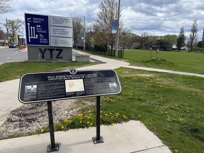
1 Ontario, Toronto, Bathurst Quay — Billy Bishop Toronto City Airport / Aéroport Billy Bishop de Toronto
Billy Bishop Toronto City Airport Opening in 1939 to take advantage of the rise in commercial aviation, Billy Bishop Toronto City Airport was built to integrate an aircraft terminal with a modern port. The Advisory Airport . . . Map (db m299682) HM
2 Ontario, Toronto, Bay-Cloverhill — Taddle Creek
Prior to colonization and urban development altering the landscape, the land Toronto now occupies was teeming with waterways that flowed through marshes and forests of pine and oak trees. Taddle Creek ran for six kilometres across land that remains . . . Map (db m274706) HM
3 Ontario, Toronto, Bloor Annex — Brunswick House1908
In 1874, Benjamin Hinchcliffe opened the first tavern on this site. It was a two storey, roughcast structure with a stable. In 1908, John Wilson Siddall designed the present building in the Edwardian Classical style. After Albert, Molly, and Morris . . . Map (db m274902) HM
4 Ontario, Toronto, Cabbagetown — The Rekai Family
The Rekai family arrived in Canada in 1950 from Paris, France, after escaping from Budapest two years earlier when the Soviet Union occupied Hungary. Upon receiving their licenses to practice medicine in Canada, brothers John and Paul purchased a . . . Map (db m274509) HM
5 Ontario, Toronto, Cabbagetown-South St.James Town — Jarvis Collegiate Institute
Fondée en 1807 l'école Jarvis est l'une des plus anciennes ecoles secondaires publiques de l'Ontario. Le reverend John Strachan, qui devait être le premier eveque anglican de Toronto, en devint le directeur en 1812 et jeta les . . . Map (db m282178) HM
6 Ontario, Toronto, Centre Island — St. Andrew By-The-Lake
After the Toronto Island parish was established in 1875 Bishop Arthur Sweatman was the prime mover in the building of this Anglican church. Designed by Arthur R. Denison, architect, the Early English Gothic style frame church was opened at the . . . Map (db m35520) HM
7 Ontario, Toronto, Chinatown — Labor Lyceum
Established in 1913 by Henry Dworkin and Sam Easser, the Labor Lyceum Association sought to advance the interests of the city's Jewish trade union movement. Through the sale of $5.00 stock certificates, the Association purchased the houses at 344 . . . Map (db m288831) HM
8 Ontario, Toronto, Chinatown — Standard Theatre1922
This building was the first purpose-built Yiddish-language theatre in Canada and a cultural landmark in the local Jewish community. Architect John MacNee Jeffrey designed the Standard Theatre in the Art Deco style, possibly with architect . . . Map (db m288830) HM
Paid Advertisement
9 Ontario, Toronto, Chinatown — Wong Association of Ontario黃江夏雲山公所
The Wong Association of Ontario (Wong Kung Har Wun Sun Association) traces its origins to one of the oldest Chinese family associations in Canada — Wong Kung Har Tong, established in 1912. It was originally located in Toronto's first Chinatown, near . . . Map (db m293791) HM
10 Ontario, Toronto, Christie Pits — Riot at Christie Pits
On August 16, 1933, at the end of a playoff game for the Toronto junior softball championship, one of the city’s most violent ethnic clashes broke out in this park (then known as Willowvale Park). Toronto was a predominantly British and Protestant . . . Map (db m297298) HM
11 Ontario, Toronto, Church-Wellesley — Joseph Bloor
Joseph Bloor (also "Bloore") was a prominent landowner, brewer, and philanthropist. Born circa 1789 in Staffordshire, England, he immigrated to the Town of York, now Toronto, in 1819 with his wife, Sarah (née Lees), and their three children. . . . Map (db m274537) HM
12 Ontario, Toronto, Church-Wellesley — Northfield
Sir Oliver Mowat (1820-1903) built this Georgian-style house in 1836 on land originally owned by Samuel Peters Jarvis. Mowat, one of the fathers of confederation, was Premier of Ontario (1872-1896) and Lieutenant-Governor of Ontario . . . Map (db m281544) HM
13 Ontario, Toronto, CityPlace — Isabella Valancy Crawford(1850-1887)
Considered among our finest poets, Isabella Crawford was born in Ireland and came to Canada with her parents about 1858. After settling first in Paisley, Ontario, the family lived later in Lakefield and Peterborough. As a young woman Isabella . . . Map (db m217200) HM
14 Ontario, Toronto, Corktown — Consumers’ Gas Company Water Gas Purification Housecirca 1899
Prior to the use of natural gas, the Consumers' Gas Company complex that once dominated this area produced both coal gas and water gas to provide light and fuel for Toronto. This building was constructed for the final purification process of water . . . Map (db m272012) HM
15 Ontario, Toronto, Corktown — House of Providence
Once one of the city's largest centres of charity, the House of Providence stood nearby for over 100 years. It was initiated by Toronto's Roman Catholic Bishop, Armand-François-Marie de Charbonnel, in response to the plight of the . . . Map (db m272089) HM
16 Ontario, Toronto, Danforth East York — William (Billy) McKay Jr. (1862 - 1943)
William McKay was an early supporter of the development of the Township of East York. In 1891, McKay bought about 16 hectares (40 acres) for a farm between present-day Sammon, Cosburn, Durant, and Glebemount Avenues. In the 1920s, McKay aided . . . Map (db m281917) HM
17 Ontario, Toronto, Danforth Village — East Toronto & the Railways292 Main Street — 1887 —
Built in the heart of a former railway town, 292 Main Street is an example of 19th-century Ontario farmhouse design, with decorative brickwork in contrasting colours. Lumber merchant and landowner Donald George Stephenson was the home's first owner . . . Map (db m309880) HM
Paid Advertisement
18 Ontario, Toronto, Deer Park — Glenn Gould1932-1982
Celebrated pianist Glenn Gould was born in Toronto and lived here on St. Clair Avenue West for much of his adult life. His visionary approach to musical interpretation brought him international acclaim. Gould was praised for his technical skill and . . . Map (db m297406) HM
19 Ontario, Toronto, Deer Park — Imperial Oil Building
Designed by architectural firm Mathers & Haldenby, this building housed the executive headquarters of the multinational petroleum corporation Imperial Oil Limited from 1957 to 2005. It was among the first major office buildings on St. Clair Avenue . . . Map (db m297401) HM
20 Ontario, Toronto, Discovery District — Dr. William T. Mustard1914-1987
Procedures pioneered by William Thornton Mustard (born 8 August 1914 in Clinton, Ontario) had an historic impact on the field of surgery. He attended the University of Toronto Schools and the University of Toronto Medical School. During WWII while . . . Map (db m217699) HM
21 Ontario, Toronto, Discovery District — School of Hygiene1927
Located in this building for more than 50 years, the University of Toronto's School of Hygiene was a vital centre for teaching and research into the prevention of disease and promotion of good health. Until 1955, this building was also home to . . . Map (db m294093) HM
22 Ontario, Toronto, Distillery District — Tank House 7 (Denaturing Room)1887
In 1920, the Canadian government granted Gooderham & Worts the right to ‘denature' alcohol (render it undrinkable by adding chemicals) for industrial use. Tank House 7 was adapted to house the denaturing operation. Designated under the . . . Map (db m270773) HM
23 Ontario, Toronto, Downtown Yonge — Canadian Bank of Commerce - Yonge-Queen Branch (1905)
Built for the Canadian Bank of Commerce, now the Canadian Imperial Bank of Commerce (CIBC), the historic bank branch at 197 Yonge Street was designed by architecture firm Darling and Pearson in the Beaux-Arts style. The building has classical . . . Map (db m282016) HM
24 Ontario, Toronto, Downtown Yonge — Confederation Life Building1892 Reported missing
Once one of Toronto's grandest office buildings, this landmark served as the headquarters of the Confederation Life Association until 1955. Plans for the building arose from an international competition won by Knox, Elliot and Jarvis, architects. . . . Map (db m217687) HM
25 Ontario, Toronto, Downtown Yonge — Cy McLean1916-1986
Cyril "Cy" George McLean was among Canada's most accomplished and celebrated jazz musicians who broke racial barriers in live music, paving the way for generations of Black musicians. Born in Sydney, Nova Scotia, McLean was introduced to the . . . Map (db m293859) HM
26 Ontario, Toronto, Downtown Yonge — Jackie Shane (1940-2019)
Jackie Shane was a pioneering transgender musician who electrified Toronto's nightclubs in the 1960s with her high-energy R&B shows. Born in Nashville, Tennessee, Shane sang in choirs as a child and joined the city's R&B scene as a teen. . . . Map (db m281567) HM
Paid Advertisement
27 Ontario, Toronto, Downtown Yonge — Le Coq d’Or Tavern
The Le Coq d'Or Tavern was one of the most popular rock'n' roll venues in Toronto in the 1950s and 1960s. Businessman George Bulucon opened the Le Coq d'Or in the late 1940s on the Yonge Street strip, a raucous entertainment district between . . . Map (db m259775) HM
28 Ontario, Toronto, Downtown Yonge — Public Health in Toronto
Toronto has faced many public health challenges in its history. In 1832 and 1834, the city experienced two outbreaks of cholera, which spread in drinking water polluted with sewage. The epidemics killed hundreds and resulted in the creation of . . . Map (db m302395) HM
29 Ontario, Toronto, Downtown Yonge — R. C. HarrisToronto's First Commissioner of Works — (1875-1945) —
who masterminded much of the City’s Vital infrastructure, lived at Old City Hall from 1900 to 1909, and worked here from 1900 to 1945.Map (db m208079) HM
30 Ontario, Toronto, Downtown Yonge — Salvation Army Territorial Headquarters
In 1886, only four years after it had come to Canada from England, a young Christian revival movement known as The Salvation Army built its Territorial Headquarters for Canada and Bermuda on this site. From 1886 to 1995, two different Headquarters . . . Map (db m288879) HM
31 Ontario, Toronto, Downtown Yonge — Town Tavern
The Town Tavern, located here for 23 years, was an important part of the Yonge Street music scene. Opened in 1949 as a theatre restaurant, club owner Sam Berger turned the Town Tavern into a full-time jazz venue in 1955 at the suggestion of . . . Map (db m217797) HM
32 Ontario, Toronto, Downtown Yonge East — ‘Deeds Speak’ Sculptural Reliefs
The adjacent York County Coat of Arms and the female figure inside the entrance once adorned the York County Registry Office, formerly located on this site. Commissioned by the County in 1941, the sculptural reliefs were created by Jacobine . . . Map (db m281947) HM
33 Ontario, Toronto, Downtown Yonge East — Adelaide Street Court House1853
This building was Toronto’s city and county courthouse for nearly 50 years. It was Toronto’s third courthouse, designed by Cumberland & Ridout in the Classical Revival style, inspired by historic Greek architecture. Many high-profile trials were . . . Map (db m217427) HM
34 Ontario, Toronto, Downtown Yonge East — Albert Jackson
Born into slavery in Delaware during the late 1850s, Albert Jackson became the first Black letter carrier in Toronto and one of the few people of colour to be appointed a civil servant in 19th-century Canada. Jackson's mother, Ann Maria, escaped . . . Map (db m217681) HM
35 Ontario, Toronto, Downtown Yonge East — Canadian Pacific Railway Building1913
Designed by architecture firm Darling & Pearson, the Toronto office of the Canadian Pacific Railway was one of the city's first skyscrapers, and briefly, the tallest building in the British Empire. Designated under the Ontario Heritage Act, . . . Map (db m302058) HM
Paid Advertisement
36 Ontario, Toronto, Downtown Yonge East — Consumers' Gas Company Building1852 (with later additions)
This building was the headquarters of the Consumers’ Gas Company for 125 years. It was built in stages between 1852 and 1899 on what was one of Toronto’s principal financial streets. Architect Joseph Sheard designed the first building at 17 Toronto . . . Map (db m217415) HM
37 Ontario, Toronto, Downtown Yonge East — Cooper and Gillespie Houses
This neighbourhood was developed in the mid-19th century as a district of mansions and upscale residential buildings, including the two townhouses that stood at the northeast corner of Shuter and Dalhousie Streets. The Edward Cooper Houses were . . . Map (db m302387) HM
38 Ontario, Toronto, Downtown Yonge East — Early Greek Orthodox Community
Between 1912 and 1938, this building was home to Toronto's first Greek Orthodox church and Greek language school. It was also an early centre of Greek identity and community. In the beginning of the 20th century, Greek immigrants settled . . . Map (db m282015) HM
39 Ontario, Toronto, Downtown Yonge East — Excelsior Life Building1915
This 11-storey building, designed by prominent Toronto architect E. J. Lennox, was the tallest building on the block at the time of construction. It was named after the Excelsior Life Insurance Company, whose offices were located within. It . . . Map (db m217511) HM
40 Ontario, Toronto, Downtown Yonge East — International Union of Operating Engineers Local 793
In 1919, 11 steam shovel operators, known today as operating engineers, gathered at the Elliott House Hotel on this site to establish the Local 793 chapter of the International Union of Steam Engineers. The Trade Unions Act, passed . . . Map (db m281986) HM
41 Ontario, Toronto, Downtown Yonge East — Ontario College of Pharmacy
In 1882, the Ontario College of Pharmacy opened Canada's first school of pharmacy, which moved into this building in 1887. A group of 18 druggists (a former term for pharmacists) founded the predecessor organization the Toronto Chemists and . . . Map (db m275783) HM
42 Ontario, Toronto, Downtown Yonge East — Original Site of Toronto Hebrew Congregation Holy Blossom
The first Jewish congregation in Canada West, (now Ontario), was established on this site in 1856 (Jewish calendar 5615). Services were held in a rented hall on the upper floor over Coombe’s Drug Store on the corner of Yonge and Richmond Streets. . . . Map (db m217697) HM
43 Ontario, Toronto, Downtown Yonge East — Perkins Block1875
Designed by architects Henry MacDougall and Frank Darling, this warehouse extension and storefront was built for Frederick Perkins, a wholesale grocer. It features brick pilasters, sash windows, and a rusticated exterior on the ground floor. . . . Map (db m270180) HM
44 Ontario, Toronto, Downtown Yonge East — Site of Toronto’s First Moving Picture Show
On August 31, 1896, a series of films running less than a minute each was projected from a "Vitascope” invented by Thomas Edison at Robinson's Musee Theatre on this site. On the next day, the Toronto World reported that the “...machine projects . . . Map (db m302254) HM
Paid Advertisement
45 Ontario, Toronto, Downtown Yonge East — St. Lawrence Hall1850
St. Lawrence Hall, one of the oldest public buildings in Toronto, was constructed following the Great Fire of 1849 that destroyed a large part of the city's core. Architect William Thomas designed the building in the Renaissance Revival style with . . . Map (db m217100) HM
46 Ontario, Toronto, Downtown Yonge East — The Athenaeum Club (1891)
Built for the Athenaeum Club, this façade was designed by the architectural firm Denison and King in a Moorish Revival style, rare in Toronto. It features intricate brickwork, several Moorish window arches, and in the balcony, a cast-iron . . . Map (db m281948) HM
47 Ontario, Toronto, Downtown Yonge East — Toronto Sculpture Garden115 King Street East
[west side] The sculpture garden in this city park was constructed with generous contributions from the Louis L. Odette family and the Province of Ontario to promote the art of sculpture for the enjoyment of the people of Toronto. An art . . . Map (db m217547) HM
48 Ontario, Toronto, Fashion District — 19 Draper Street1881
For 60 years, this site contained a Second Empire style home identical to the one located next doot. Built by the developer Jonathan Madell, the first resident of 19 Draper Street was George Hickey, a railway manager. In 1942, the house was . . . Map (db m277038) HM
49 Ontario, Toronto, Fashion District — 21 Draper Street1881
For 60 years, this site contained a Second Empire style home identical to the one located next door. Built by the developer Jonathan Madell, the first residents of 21 Draper Street were Elspeth Jones and her family. In 1942, the house was demolished . . . Map (db m277042) HM
50 Ontario, Toronto, Fashion District — 29 Draper Street1881
1st Resident Charles Cluthe, machinist Builder Richard Humphries Designated under the Ontario Heritage Act, 1999 Birthplace of the Honourable Lincoln M. Alexander (b. 1922) First Black Member of Parliament in Canada, 1968 First Black . . . Map (db m277033) HM
51 Ontario, Toronto, Fashion District — Balfour Building1930
Designed with Art Deco ornamentation by architect Benjamin Brown, this building was commissioned by Jewish entrepreneurs and occupied by a number of notable clothing businesses over the years, including the Shiffer Hillman Clothing Co. Together with . . . Map (db m277242) HM
52 Ontario, Toronto, Fashion District — Canadian Westinghouse Building1927
Built in 1927, the Canadian Westinghouse Building was a warehouse and district office for the Canadian Westinghouse Co. based in Hamilton, Ontario. American entrepreneur George Westinghouse (1846-1914) patented thousands of inventions, most . . . Map (db m276941) HM
53 Ontario, Toronto, Fashion District — Copp Clark Co. Complex1909 (with additions)
This collection of industrial buildings was designed by architectural firm Wickson and Gregg for Copp Clark Co., which became Canada's longest continuously operating book publisher. Founded as a printing company by Hugh Scobie in 1841, the business . . . Map (db m277071) HM
Paid Advertisement
54 Ontario, Toronto, Fashion District — Draper Street
Draper Street's Empire-style cottages were built in 1881 and 1882, while its larger homes were constructed between 1886 and 1889. The street - a designated heritage conservation district - is unusual because its residential character survived the . . . Map (db m277043) HM
55 Ontario, Toronto, Fashion District — George Crookshank Housecirca 1834
Built as a pair of Georgian, semi-detached houses by George Crookshank, a prominent businessman and politician, this building has had a variety of uses. In 1876, it was converted into a girls' school. A third floor was added and the residences were . . . Map (db m277024) HM
56 Ontario, Toronto, Fashion District — Phillips Garment Co. Fire
On January 20, 1950, nine garment workers died as a result of a factory fire on this site. The disaster highlighted poor working conditions and a general lack of safety in Toronto's garment factories. The fire in the Phillips garment factory . . . Map (db m277239) HM
57 Ontario, Toronto, Fashion District — St. Andrew’s Market and Playground
This city block was set aside in 1837 for a public market, the third of its kind after the St. Lawrence (1803) and St. Patrick's (1836) Markets. Built in 1850 and eventually named "St. Andrew's" for its city ward, the market was an important . . . Map (db m277209) HM
58 Ontario, Toronto, Fashion District — Waterworks Building1932
This historic Art Deco façade was built as part of the Waterworks Building, an important facility within Toronto's water system. When it opened, the complex housed workshops, offices, and storage for equipment and materials. Designed by James . . . Map (db m288817) HM
59 Ontario, Toronto, Financial District — Founding of the Empire Club
On this site in 1903, the Empire Club of Canada was established as a place for political discussion. Focused on British imperialism and the link between Canada and the British Empire, the club met at Harry Webb's Restaurant. The desire to start . . . Map (db m272187) HM
60 Ontario, Toronto, Financial District — Hotel Victoria1909
Opened as the Hotel Mossop, this eight-story structure was one of Toronto’s first fireproof buildings. It was constructed in the aftermath of the 1904 Great Fire of Toronto, which destroyed over 100 buildings west of here. As a result, architect J. . . . Map (db m217516) HM
61 Ontario, Toronto, Financial District — Sir John A. Macdonald Plaza
Upon the Confederation of Canada on July 1, 1867, Sir John A, Macdonald (1815-1891) became Canada's first prime minister. His government completed construction of the transcontinental Canadian Pacific Railway in 1885. Before Macdonald became prime . . . Map (db m302053) HM
62 Ontario, Toronto, Financial District — The Canadian Bank of Commerce Building1929-1931
Upon completion, this 34-storey skyscraper was the tallest building in the British Empire and was praised as the “greatest addition to Toronto’s increasing, Manhattan-like skyline.” It was designed for The Canadian Bank of Commerce jointly by the . . . Map (db m217198) HM
Paid Advertisement
63 Ontario, Toronto, Financial District — The Dominion Bank Building1914
Founded in Toronto in 1869, the Dominion Bank moved its head office to this site ten years later. In 1914, the bank's rise to national prominence led to the construction of this early 12-storey skyscraper. Beaux-Arts in style with Renaissance . . . Map (db m217451) HM
64 Ontario, Toronto, Financial District — 4 — The National Club
Established in 1874 to foster national sentiment and to give the “Canada First Movement” a home, the club began in a building on the Site of the Toronto Stock Exchange. Expanding membership necessitated new facilities and in 1907 these premises, . . . Map (db m302063) HM
65 Ontario, Toronto, Financial District — The Royal Canadian Naval Volunteer Reserve
The adjacent plaque was the first created by the Toronto Historical Board, and was installed in 1969 on an earlier building on this site. It marks the first place in Toronto where citizens were recruited and trained by the Royal Canadian Naval . . . Map (db m217587) HM
66 Ontario, Toronto, Fort York-Liberty Village — Ben Dunkelman1913-1997
Ben Dunkelman was a distinguished military officer, entrepreneur, and president of Tip Top Tailors, the menswear company founded by his father, David. Born and raised in Toronto, Ben Dunkelman fought with the Queen's Own Rifles of Canada regiment . . . Map (db m211254) HM
67 Ontario, Toronto, Fort York-Liberty Village — Designing The CNE's Grand Entrance
The design of a grand eastern entrance to the Canadian National Exhibition (CNE) was the result of visionary waterfront planning by Toronto architect Alfred H. Chapman. In the early 1920s, he was commissioned by the CNE to plan a major expansion of . . . Map (db m212905) HM
68 Ontario, Toronto, Fort York-Liberty Village — Queen's Wharf Lighthouse
Now landlocked on Fleet Street, this lighthouse once stood on the Queen's Wharf. The wharf - originally known as New Pier - was built in 1833 to stimulate commercial activity in the west part of the harbour. This lighthouse, constructed in 1861 . . . Map (db m211603) HM
69 Ontario, Toronto, Garden District — O’Donohoe Row (Walnut Hall)
In 1857, Alderman John O'Donohoe commissioned a row of four Georgian-style townhomes on this site and marketed them to wealthy buyers as O'Donohoe Row. Architect John Tully designed the homes with yellow buff brick, gable roofs, and dormer . . . Map (db m281945) HM
70 Ontario, Toronto, Garden District — St. Andrew’s Church
Designed by Langley & Burke in gothic style and built of Credit Valley stone, this church was dedicated 17 March 1878. The Rev. Dr. G. M. Milligan, the first minister, who served here for over two decades, initiated its construction for his . . . Map (db m282021) HM
71 Ontario, Toronto, Grange Park — Church of Christ (1891)
This building was designed by the architecture firm of Knox and Elliot as a Romanesque Revival-style church for a congregation of the Disciples of Christ. Its subsequent uses tell the story of a changing neighbourhood. The church became the . . . Map (db m281515) HM
Paid Advertisement
72 Ontario, Toronto, Grange Park — University Club of Toronto Building1929
Founded in 1906 as a private dining club for those with a university degree, the University Club of Toronto moved to this location on Toronto's ceremonial avenue in 1929. A design competition for a new building — restricted to architects who were . . . Map (db m217701) HM
73 Ontario, Toronto, Harbord Village — Dr. Anderson Ruffin Abbott1837-1913
Dr. Abbott was among the first Black Canadians licensed as a medical doctor. Anderson Abbott was born in Toronto to Wilson and Ellen Abbott, business owners who fled racial violence in Alabama in 1834. They settled in Toronto, where Wilson . . . Map (db m288849) HM
74 Ontario, Toronto, Harbord Village — Young Men’s - Young Women’s Hebrew Association
Early in the last century, athletic and social clubs were established to offer recreational opportunities to Toronto's Jewish young people. In 1919, a number of those clubs joined to form an umbrella organization that developed by 1936 into the . . . Map (db m274875) HM
75 Ontario, Toronto, Harbourfront-CityPlace — Brotherhood of Sleeping Car Porters
For several decades until the late 1980s, this site was a large coach yard where sleeping car porters working for the Canadian Pacific Railway (CPR) prepared passenger cars for travel to the United States and across Canada, which could take up to . . . Map (db m288790) HM
76 Ontario, Toronto, Harbourfront-CityPlace — Fanny “Bobbie” Rosenfeld1904-1969
Fanny "Bobbie" Rosenfeld was one of Canada's greatest Olympic athletes. She helped pave the way for women in sport. Around 1905, Rosenfeld's family immigrated to Canada from Yekaterinoslav, Russia (today Dnipro, Ukraine), to escape . . . Map (db m288792) HM
77 Ontario, Toronto, Huron Sussex — “Stop Spadina Save Our City”
For many people, the Spadina Expressway was necessary for Toronto to adapt to modern needs. For others, it promised only the destruction of homes and parks, more traffic congestion, and pollutants from automobile exhaust. Citizen-led efforts . . . Map (db m274789) HM
78 Ontario, Toronto, Huron Sussex — After the Spadina Expressway
The cancellation of the Spadina Expressway in 1971 left a section completed from Wilson Avenue in the north to Lawrence Avenue in the south. Now known as the William R. Allen Road, the expressway was opened to Eglinton Avenue in 1976, while the . . . Map (db m274829) HM
79 Ontario, Toronto, Huron Sussex — Saint Thomas’s Anglican Church
Saint Thomas's was founded in 1874 as the Anglican parish church for Seaton Village. The congregation relocated twice before moving to a new, larger building on this site in 1893. A fine example of the arts and crafts style, it was designed by . . . Map (db m274772) HM
80 Ontario, Toronto, Huron Sussex — Spadina Expressway
In the 1960s, this stretch of Spadina Road was to be transformed into the southern end of a sunken, four- to six-lane expressway, and a subway line. They would connect downtown Toronto with Highway 401, but the expressway would require the . . . Map (db m274776) HM
Paid Advertisement
81 Ontario, Toronto, King West Village — King Street West Railway Subway (Underpass)1888
This railway underpass is one of the oldest in the City of Toronto. Rail lines were first built through this area in the 1850s, Connecting Toronto to the upper Great Lakes and points in-between. By the 1880s, multiple tracks had been constructed to . . . Map (db m259543) HM
82 Ontario, Toronto, King West Village — Massey-Harris Company
This office building, constructed in 1883, is the only surviving structure from the Massey-Harris manufacturing complex. Designed by notable Toronto architect E.J. Lennox, the building combines elements of the Queen Anne Revival style (arches, . . . Map (db m259545) HM
83 Ontario, Toronto, Leslieville — Jefferson Glass Co. FactoryLater ACME Paper Box Co
A major producer of blown and pressed glass in Ontario opened here in the early 1910s. The Jefferson Glass Co. specialized in light shades and illuminated signs and by 1918 it was also making about 35,000 light bulbs a day. The Acme Paper Box . . . Map (db m288861) HM
84 Ontario, Toronto, Little Malta — The Maltese Community of Toronto
A small number of immigrants from Malta first arrived in Toronto in the late 19th century. By 1916, having fled overpopulation and unemployment, some 200 Maltese had established themselves in Toronto in two communities. One was the area of Dundas . . . Map (db m296448) HM
85 Ontario, Toronto, Midtown Toronto — Ernest Hemingway in Toronto
American author Ernest Hemingway (1899-1961) known for A Farewell to Arms (1929), For Whom the Bell Tolls (1940), and The Old Man and the Sea (1952) lived here from 1923 to 1924. Born in Oak Park, Illinois, Hemingway started his . . . Map (db m297305) HM
86 Ontario, Toronto, New Toronto — Bell Telephone Company Building1926
Designed in Edwardian Classical style by Montreal architect W. J. Carmichael, this building was constructed to accommodate the switching equipment, switchboard operators, and technicians needed for Bell Telephone's rapidly expanding service in this . . . Map (db m310664) HM
87 Ontario, Toronto, Old Mill — The Lost Village of Milton Mills
[left panel] Linking Lake Ontario to Lake Simcoe and the upper Great Lakes, the Humber River has been vital to human habitation for thousands of years. Artifacts from a 16th-century First Nations community, as well as substantial findings from a . . . Map (db m310530) HM
88 Ontario, Toronto, Old Town — 363-365 Adelaide St. East1842
These two attached houses are rare examples of Georgian-style residences that used to be common in Toronto. They were built for Paul Bishop, a blacksmith and landlord whose shop stood across the street. Designated under the Ontario Heritage . . . Map (db m272146) HM
89 Ontario, Toronto, Old Town — Berkeley Street Firehall No. 41905
This building was designed by architect A. Frank Wickson in the Edwardian Classical style to replace an earlier firehall on this site. Marked by arched gables, it also features rich contrasts in brick and stone, most visible around the grand . . . Map (db m272143) HM
90 Ontario, Toronto, Old Town — Chief WabakinineD. 1796
Chief Wabakinine was Head Chief of the Mississaugas of western Lake Ontario, whose traditional territory includes the Toronto area. As Head Chief, he led by resolving issues through discussion until a consensus was reached. While he was Chief, . . . Map (db m270447) HM
91 Ontario, Toronto, Old Town — Cholera Epidemics of 1832 & 1834
On June 21, 1832, the first cases of cholera, a highly contagious and deadly disease, appeared in the Town of York. Much feared, cholera first appeared in India in the 1770s, spreading along trade routes to Asia and Europe, and arriving in London, . . . Map (db m217097) HM
92 Ontario, Toronto, Old Town — De La Salle Institute Building1871
Designed by Toronto architect Henry Langley, this building was constructed as a boys school operated by the Brothers of the Christian Schools, a Catholic teaching order. The Brothers had purchased the former Bank of Upper Canada building to the . . . Map (db m217698) HM
93 Ontario, Toronto, Old Town — Francis Collins
Francis Collins, Canada’s first professional parliamentary debates reporter, was born ca. 1800 in Newry, County Down, Ireland. He had been a publisher before his arrival in York (Toronto) where, near here from 1825-1834 he published the “Canadian . . . Map (db m217798) HM
94 Ontario, Toronto, Old Town — George Brown CollegeSt. James Campus — 1874 —
Canada’s largest biscuit manufacturer, Christie, Brown & Co., built this factory complex over a 40-year period. At its peak, it employed nearly 400 workers. The original three-storey building was enlarged and altered in a variety of architectural . . . Map (db m217792) HM
95 Ontario, Toronto, Old Town — Imperial Bank of Canada1908
This two-storey Edwardian Classical bank was designed for the Imperial Bank of Canada by the Toronto firm, Darling and Pearson, Architects. After the bank merged with The Canadian Bank of Commerce in 1961, the building continued as a branch of the . . . Map (db m271975) HM
96 Ontario, Toronto, Old Town — Little York Hotel1880
Toronto architecture firm Langley, Langley & Burke designed this building and its accompanying stables on George Street. It is a rare example of decorative Second Empire architecture, with intricately carved keystones over the windows. Robert . . . Map (db m271934) HM
97 Ontario, Toronto, Old Town — St. James Parking Garage
The St. James Parking Garage, which opened in 1925, was one of the first multi-level parking garages in Toronto. In the mid-1920s, increased demand for parking led to the construction of several parking garages in Toronto’s downtown core. . . . Map (db m217857) HM
98 Ontario, Toronto, Old Town — The Cathedral Church of St. James
In 1796 the first Anglican priest arrived from England to minister to the citizens of York. The following year the province set aside this piece of land for the building of a church. The present cathedral, the fourth church erected on this site, . . . Map (db m217444) HM
99 Ontario, Toronto, Old Town — The Daniel Brooke Building
This building was first constructed in 1833 for owner Daniel Brooke, a prominent merchant in the Town of York. It was substantially rebuilt between 1848-1849 prior to the Great Fire of April 1849 which started in a nearby stable. While much of the . . . Map (db m217196) HM
100 Ontario, Toronto, Old Town — Underground Railroad RestaurantKing Street
The Underground Railroad restaurant was one of the first Black-owned and operated soul food establishments in Toronto. It opened on February 12, 1969, in the basement of 406 Bloor Street East and soon became a destination for locals as well as . . . Map (db m271949) HM

151 entries matched your criteria. The first 100 are listed above. The final 51 ⊳
 
 
CeraNet Cloud Computing sponsors the Historical Marker Database.
This website earns income from purchases you make after using our links to Amazon.com. We appreciate your support.
Paid Advertisement
Sep. 11, 2026
