On Alt. US 13 Front Street at Courthouse Ave., on the right when traveling north on Alt. US 13 Front Street.
Here stood the birthplace of Henry Alexander Wise (1806-1876), Governor of Virginia (1856-1860) and general in the Confederate States Army. A talented orator and debator in an age of great orators, Wise was elected to six terms in Congress. He . . . — — Map (db m7823) HM
On South Street at Market Street, in the median on South Street.
Born June 2, 1840. Died June 13, 1876. His life was gentle and the elements So mixed in him that Nature might stand up And say in all the World. This was a man. — — Map (db m7678) HM
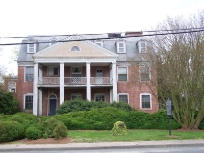
On West Street at Market Street, on the right when traveling south on West Street.
Built in 1854, Cokesbury Church is the oldest church building in Onancock. Today it serves the community as a venue for religious services, meetings, and concerts. Key events in its history include:
On Cassatt Avenue (Virginia Route 316) at Mary Street, on the right when traveling south on Cassatt Avenue.
Erected by Harmanson-West Camp Confederate Volunteers in memory of their dead comrades from Accomack and Northampton Counties
They died for the principles upon which all true republics are founded
They fought for conscience sake and . . . — — Map (db m165074) WM
On Ivy Road (Business U.S. 250) near Colonnade Drive. Reported permanently removed.
On 3 Mar. 1865, Maj. Gen. Philip H. Sheridan’s Union Army of the Shenandoah entered Charlottesville to destroy railroad facilities as the 3rd Cavalry Division led by Bvt. Maj. Gen. George A. Custer arrived from Waynesboro. Mayor Christopher H. . . . — — Map (db m95140) HM
On Ivy Road (Business U.S. 250) just west of Colonnade Drive, on the right when traveling east.
On 3 Mar. 1865, after the Battle of Waynesboro, Maj. Gen. Philip H. Sheridan's Union Army of the Shenandoah entered Charlottesville. As Bvt. Maj. Gen. George A. Custer's 3d Cavalry Division arrived, Mayor Christopher L. Fowler, local officials, and . . . — — Map (db m170640) HM
Near Woodbrook Drive west of Seminole Trail (U.S. 29).
Civil War relic collectors found Stuart’s winter camp and skirmish site (shaded area of map) long before the Rio Hill Shopping Center opened in 1989.
Metal detectors were used to search the area and artifacts—bullets, buttons, belt and . . . — — Map (db m7692) HM
Near Woodbrook Drive west of Seminole Trail (U.S. 29).
In December 1863, Confederate troops established winter quarters here. The approximately 200 soldiers, under the command of Capt. Marcellus N. Moorman, were from Stuart’s Horse Artillery Battalion and were equipped with 16 cannons. The men built . . . — — Map (db m7690) HM
Near Woodbrook Drive west of Seminole Trail (U.S. 29).
On February 29, 1864, General George A. Custer and 1500 cavalrymen made a diversionary raid Into Albemarle County. Here, north of Charlottesville, he attacked the Confederate winter camp of four batteries of the Stuart Horse Artillery commanded by . . . — — Map (db m7685) HM
On East Market Street (County Road 1105) 0.2 miles south of Riverside Avenue, on the right when traveling east.
The Woolen Mills area of Charlottesville traces its roots back to the late 1700s. It was Thomas Jefferson who realized the Rivanna River's vitality was the key to economic growth in the area.
Originally a grist mill was started on . . . — — Map (db m172975) HM
On Rio Mills Road (County Route 643) at Seminole Road (U.S. 29), on the right when traveling west on Rio Mills Road.
The 19th-century mill village of Rio Mills stood 600 yards west of here, where the former Harrisonburg-Charlottesville Turnpike crossed the South Fork of the Rivanna River. Following the Battle of Rio Hill on 29 February 1864, Union General George . . . — — Map (db m106830) HM
On Ivy Road (U.S. 250) east of Three Notched Road (Virginia Route 240). Reported missing.
Late in April 1862, Maj. Gen. Thomas J. “Stonewall” Jackson marched his army out of the Shenandoah Valley through the Blue Ridge Mountains to deceive Union Maj. Gen. John C. Fremont into thinking he was headed for Richmond. On 3 May, Jackson . . . — — Map (db m230172) HM
On Ivy Road (U.S. 250) 0.1 miles west of Gillums Ridge Road (Virginia Route 787), on the right when traveling west.
During the Shenandoah Valley Campaign (March - June 1862) Confederate Maj. Gen. Thomas J. "Stonewall" Jackson used deceptive maneuvers and sharp attacks to divert Union forces from the Peninsula Campaign against Richmond. Late in April, Jackson's . . . — — Map (db m209781) HM
On East Main Street (Virginia Route 6) just east of Valley Street (Virginia Route 20), on the right when traveling east.
At 3 p.m. on Monday, March 6, 1865, the first of Union Gen. Philip H. Sheridan’s 10,000 cavalrymen under Gens. Wesley Merritt, Thomas Devin, and George A. Custer entered Scottsville unopposed. To accomplish their mission—destroy the
James . . . — — Map (db m17844) HM
On Hardware Street (Virginia Route 795) 0 miles north of Valley Street (Virginia Route 20).
In memory of the soldiers who died in the Confederate General Hospital in Scottsville
1862-1863
Beattie, F.M. Co. H 23 NC
Boyle, Andrew Co. D 41 VA
Brashear, Denis P. Co. E 4 AL
Clark, Henry Co. E 15 AL
Clark, Hosey L. Co. F 2 MS . . . — — Map (db m22784) HM
On Eisenhower Avenue, 0.8 miles east of Metro Road, on the right when traveling east.
Josiah Watson, a wealthy merchant and postmaster of Alexandria, established his 272-acre plantation, “Bush Hill”, in 1791. Richard Marshall Scott purchased the plantation in 1791; his family stayed here for 200 years. Scott was an . . . — — Map (db m2610) HM
On North Paxton Street at Cloude's Mill Drive, on the right on North Paxton Street.
This historic site is a section of the mill race that provided water power to Cloud's Mill which stood directly across Paxton street.
At the intersection of Beauregard and Morgan Streets, water diverted from the Holmes Run ran through the . . . — — Map (db m150801) HM
On King Street (Virginia Route 7) near South Taylor Street, on the right when traveling east.
Episcopal High School, on the hill to the southwest, was founded in 1839 as a boys' preparatory school, one of the first in the South; girls were admitted in 1991. The school was a pioneer in the establishment of student honor codes in preparatory . . . — — Map (db m7559) HM
On King Street (Virginia Route 7) near South Taylor Street, on the right when traveling east.
Half mile to the southwest. The idea for such an institution was conceived by a group of Alexandria and Washington clergymen in 1818. Among those interested was Francis Scott Key, author of the Star Spangled Banner. Originally at corner of . . . — — Map (db m7561) HM
On South Lee Street just south of Wilkes Street, on the left when traveling south.
During the Civil War, thousands of formerly enslaved individuals came to Union-controlled Alexandria to seek refuge and freedom. As a result, several new African American neighborhoods developed during and after the Civil War, including four in . . . — — Map (db m239750) HM
Near North Union Street east of Fayette Alley, on the right when traveling north. Reported missing.
13,000 years ago
The Paleoindian Period
A Native American hunter during the Paleoindian period discards a broken spear point, on a bluff overlooking a tributary to the Potomac River at the southern edge of present-day Alexandria. . . . — — Map (db m166409) HM
On King Street at North Union Street, on the left when traveling east on King Street.
The launch of urban renewal in 1965 led to a boom of archaeological discoveries in Alexandria's Old and Historic District. As buildings were razed exposing artifact-laden layers of history, community outcry demanded that the City address and halt . . . — — Map (db m115770) HM
Near Wilkes Street at South Royal Street, in the median.
Three railroads developed in Alexandria during the mid-19th century, a period of limited industrial expansion for the City. Alexandrians had a invested heavily in the Alexandria Canal which opened in 1843, giving the city access to the rich . . . — — Map (db m72379) HM
On South Lee Street at Green Street, on the right on South Lee Street.
Historical Site Defenses of Washington 1861-1865 Battery Rodgers
Here stood Battery Rodgers, built in 1863 to prevent enemy ships from passing up the Potomac River. The battery had a perimeter of 30 yards and mounted five 200 pounder Parrott . . . — — Map (db m41413) HM
On Prince Street east of South Alfred Street, on the left when traveling east.
This property
has been listed on the
National Register
of Historic Places
by the United States
Department of the Interior
Bayne-Fowle House
1854
[Additional plaques above:]
The Bayne-Fowle House
has been . . . — — Map (db m134975) HM
On Prince Street at South Pitt Street on Prince Street.
Brigadier General Montgomery D. Corse, CSA
Born here in 1816, died Alexandria 1895.
Volunteer, Mexican War 1846-1848.
Prospector in California,
Commander, 17th Virginia Infantry Regiment, CSA.
Post-war civic leader and banker.
Buried . . . — — Map (db m65489) HM
On King Street (Virginia Route 7) at North Columbus Street, on the left when traveling east on King Street.
Before the American Revolution, the Church of England was the established church of Virginia and part of the colonial government. For administrative purposes, the colony was divided into "parishes" and all residents paid taxes to maintain church . . . — — Map (db m115716) HM
Near North Fairfax Street south of Cameron Street, on the right when traveling north.
Civil War Comes to Carlyle House
If you stood in this spot 150 years ago, you would be inside a building! In 1848 James Green purchased Carlyle House and the building in front of you, the first Bank of Alexandria. He turned it into a hotel . . . — — Map (db m129170) HM
On North Washington Street south of Cameron Street, on the right when traveling south.
"How sleep the brave who sink to rest
By all their country's wishes blest"
Beneath this mound lie the remains of thirty-four
Confederate Soldiers
Which were disinterred from the Alexandria Soldiers' Cemetery . . . — — Map (db m129286) HM WM
On King Street at North Pitt Street, on the left when traveling east on King Street.
One of King Street's greatest commercial buildings was built by one of Alexandria's most beloved citizens. Edgar Warfield, Jr. was born in 1842, and at the age of 18 he co-founded the "Old Dominion Rifles," a Confederate militia that served in . . . — — Map (db m115749) HM
On North Union Street at Princess Street, on the right when traveling north on North Union Street.
As Virginia's population grew, so did its reliance on fish from the Potomac River as a dietary staple. In 1813, the city authorities passed a law designating the county wharf at the foot of Oronoco Street as the official place for landing fish. . . . — — Map (db m239715) HM
On King Street (Virginia Route 7) at North West Street, on the right when traveling west on King Street.
The building at 1315 Duke Street, two blocks south of here, was originally built around 1812 as a residence for General Robert Young, commander of Alexandria's militia, who died in 1824. This three-story brick building then became the . . . — — Map (db m115706) HM
On King Street at North Royal Street, on the right when traveling west on King Street.
Gadsby's Tavern Museum consists of two buildings — the smaller c.1875 tavern and larger 1792 City Tavern and Hotel. While both were constructed by John Wise, they were made famous by John Gadsby, a rising tavern keeper who rented the buildings . . . — — Map (db m115755) HM
This building dates to 1801. Between 1852-1911 the Alexandria Gazette newspaper was printed here. In 1862 while Alexandria was occupied by the North during the Civil War, Union soldiers burned this building because it was reported here that St. Paul . . . — — Map (db m41832) HM
Near Jefferson Street at South Lee Street when traveling east.
The area around Jones Point, which lies just south of the nation’s capital, was an obvious location for early defensive fortifications. During the Civil War (1861-1865), Battery Rodgers was built overlooking the cove to guard the river approach . . . — — Map (db m69911) HM
On King Street at North Fairfax Street, on the left when traveling east on King Street.
Alexandria was named for the family of John Alexander, a Virginia planter who in 1669 acquired the tract on which the town began. By 1732, the site was known as Hunting Creek Warehouse and in 1749 became Alexandria, thereafter a major 18th-century . . . — — Map (db m47) HM
On Oronoco Street east of North Washington Street (Virginia Route 400), on the right when traveling east. Reported permanently removed.
Robert E. Lee left this home that he loves so well to enter West Point. After Appomattox he returned and climbed the wall to see “if the snowballs were in bloom.” George Washington dined here when it was the home of William Fitzhugh, Lee’s kinsman . . . — — Map (db m8548) HM
On King Street at North Washington Street (Virginia Route 400), on the right when traveling west on King Street.
Revolutionary War hero Henry "Light Horse Harry" Lee, father of Confederate General Robert E. Lee, purchased several lots on North Washington Street in Alexandria soon after the War for Independence. He lived with his family in a house on Cameron . . . — — Map (db m115721) HM
Near North Union Street south of Cameron Street, on the right when traveling north. Reported permanently removed.
Discover the spirit of Alexandria that has been making history for well over two centuries
Founded in 1749, Alexandria was the center of commercial and political activity for early patriots such as George Washington as the seeds of the . . . — — Map (db m115776) HM
On King Street at South Pitt Street, on the right when traveling east on King Street.
In the early morning hours of May 24, 1861, the day after a public referendum in Virginia supported secession from the United States, Alexandria was invaded by Union forces crossing the Potomac. Colonel Elmer E. Ellsworth, the young commander of the . . . — — Map (db m115753) HM
Near Wilkes Street east of South Royal Street, on the left when traveling east.
Orange & Alexandria Railroad roundhouse, formerly located near Duke and South Henry Streets. Engine named after Brigadier General Herman Haupt, Chief of Transportation, U.S. Military Railroads during the Civil War. Mathew Brady photograph after . . . — — Map (db m72622) HM
On Oronoco Street just east of North Washington Street, on the right when traveling west.
This Federal-style townhouse and its adjoining twin were built ca. 1793. Original owner John Potts, Jr., secretary of the Potomac Company, deeded the house in 1799 to William Fitzhugh of Chatham, member of Virginia's Revolutionary Conventions and . . . — — Map (db m188751) HM
On North Royal Street at Cameron Street, on the right when traveling north on North Royal Street.
After Virginia seceded in the spring of 1861, Unionists met in Wheeling and organized a state government loyal to the U.S. under Gov. Francis H. Pierpont. The Restored Government, which sent representatives to the U.S. Congress and raised federal . . . — — Map (db m191972) HM
On King Street at South Fairfax Street, on the right when traveling east on King Street.
The Stabler-Leadbeater Apothecary Museum traces one of America's oldest continuously-run family businesses that combined manufacturing, wholesaling and retailing. Founded in 1792, and operated just across Fairfax Street until 1933, the pharmacy . . . — — Map (db m115762) HM
On King Street (Virginia Route 7) at North Washington Street (Virginia Route 400), on the right when traveling east on King Street.
One block south is The Alexandria Lyceum, formed as a public education organization in 1834 by Quaker schoolmaster Benjamin Hallowell and other civic leaders. In 1839, the founders joined with the Alexandria Library Company to construct a . . . — — Map (db m115718) HM
On King Street at South Lee Street, on the right when traveling east on King Street.
Home to the Northern Virginia Fine Arts Association, the Athenaeum is a fine example of Greek Revival architecture, with a long and colorful history of occupation. The building was constructed between 1851 and 1852 as the Bank of the Old Dominion, . . . — — Map (db m115768) HM
On Prince Street just west of South Royal Street, on the right when traveling west.
Here Union Governor Francis Harrison Pierpont established the “Restored Government of Virginia” and used the building as the official Governor's Residence
1863-65
This Property is protected by a preservation easement held by . . . — — Map (db m71611) HM
Near Ford's Landing Way at Franklin Street, on the left when traveling south.
With the outbreak of war in the spring of 1861, Alexandria was immediately occupied by Federal troops as a bulwark in the defenses of the national capital, and the city became a central distribution center for men and material for the Army of the . . . — — Map (db m70411) HM WM
On North Union Street at Cameron Street, on the right when traveling north on North Union Street.
In 1860, Alexandria was a vibrant southern city boasting a population of 12,652 and 96 firms which produced everything from bark to tin-ware. During the U.S. Presidential campaign in the fall of 1860, business-minded Alexandrians were decidedly . . . — — Map (db m115781) HM
On South Washington Street (Virginia Route 400) at Prince Street, on the right when traveling south on South Washington Street. Reported permanently removed.
The unarmed Confederate soldier standing in the intersection of Washington and Prince Streets marks the location where units from Alexandria left to join the Confederate Army on May 24, 1861. The soldier is facing the battlefields to the South where . . . — — Map (db m8605) HM
On Strand Street just south of King Street, on the right when traveling north.
On January 1, 1808, the earliest date allowed by Article I, Section 9 of the United States Constitution, the Act Prohibiting Importation of Slaves went into effect and stated, "It shall not be lawful to import or bring into the United . . . — — Map (db m188750) HM
Near Jones Point Drive, 0.2 miles South Royal Street, on the right when traveling east.
From the late 1700s into the 1800s, the pastoral calm of the Point was interrupted repeatedly—by soldiers manning cannon emplacements, by surveyors laying out the boundaries of the nation's capital, by workers at a ropewalk and the lighthouse, . . . — — Map (db m62029) HM
On South Washington Street (Virginia Route 400) south of Prince Street, on the right when traveling south.
Built in 1839 by the Alexandria Lyceum Company under the leadership of Benjamin Hallowell, this building housed the Alexandria Library and was the scene of concerts, meetings, debates and lectures featuring such speakers as John Quincy Adams and . . . — — Map (db m8607) HM
On King Street, on the right when traveling east. Reported permanently removed.
The Marshall House stood upon this site, and within the building on the early morning of May 24, 1861 James W. Jackson was killed by Federal soldiers while defending his property and personal rights as stated in the verdict of the coroners . . . — — Map (db m65490) HM
On Prince Street east of The Strand, on the right when traveling west.
From 1898 to 1911, a 181-foot-long side wheel steamboat based out of Washington, D.C., called the River Queen would sometimes dock at the wharf at the foot of Prince Street in Alexandria. Build in 1864, it had first gained fame as the site . . . — — Map (db m239733) HM
Near Cameron Street east of North Union Street, on the right when traveling east. Reported permanently removed.
Welcome to Old Town Alexandria! Experience historical charm with contemporary flair from the river to the rails
Plan
Alexandria Visitors Center at Ramsay House
Knowledgeable staff help you create a perfect plan for your . . . — — Map (db m167097) HM
On Jones Point Drive east of South Royal Street, on the right when traveling east.
The open vistas, recreational fields, or fishing pier may be what drew you to Jones Point Park, but archaeological and historical evidence shows that this land has been attracting people for a multitude of reasons during the last 9,000 years. Over . . . — — Map (db m127766) HM
Near Wilkes Street at South Royal Street, in the median.
The Wilkes Street Tunnel was part of the Orange & Alexandria Railroad, founded in 1848 to promote trade with western Virginia. The Orange and Alexandria inaugurated its track in Alexandria on May 7, 1851 with a run to the north end of Union Street . . . — — Map (db m72346) HM
On South Union Street, 0.1 miles south of Wolfe Street, on the right when traveling south.
The Wilkes Street Tunnel was part of the eastern division of the Orange & Alexandria Railroad, founded in 1848 to promote trade with western Virginia. The Orange & Alexandria inaugurated its track in Alexandria on May 7, 1851 with a run from the . . . — — Map (db m143378) HM
On South Union Street just north of Gibbon Street, on the left when traveling north.
Now a city park, Windmill Hill got its name from the windmill built here on Miller's Cliff by inventor John R. Remington in 1843. With soothing winds and a grand view of the busy port, the hill was the scene of fashionable promenades and numerous . . . — — Map (db m143377) HM
On South Lee Street south of Franklin Street, on the right when traveling north.
A small group of Christian believers established Zion Baptist Church in 1864 on the corner of Wolfe and South Union Streets, northeast of the Wilkes Street Tunnel. At the end of the Civil War, Zion Baptist was one of five African American Baptist . . . — — Map (db m239753) HM
On Wythe Street just east of North Pitt Street, on the right when traveling east.
During the Civil War, an influx of self-emancipated slaves (often referred to as "contrabands") arrived in Alexandria. For several decades thereafter, this population, along with other free Black migrants, changed the racial character of both the . . . — — Map (db m204837) HM
On North Washington Street south of Pendleton Street, on the right when traveling north.
Alexandria's First Cotton Factory
On April 19, 1847, the Mount Vernon Manufacturing Company purchased this lot along North Washington Street. The present building on this site was completed a year later in 1848, becoming the city's first . . . — — Map (db m127782) HM
On North Washington Street just north of Princess Street, on the left when traveling north.
Over the course of the Civil War (1861-1865), the Union Army Surgeon General of Alexandria opened over 30 military hospitals with 6,500 beds within the city limits. Grosvenor Hospital was added as a branch of Mansion House on August 17, 1862, and . . . — — Map (db m185293) HM
On King Street (Virginia Route 7) at Commonwealth Avenue on King Street.
Shuter's Hill, a high bluff overlooking King Street, is probably named for the a local resident named Shuter who lived nearby in the 1740s. The site has been visited by people for more than 5,000 years. In fact, archaeologists have uncovered . . . — — Map (db m115785) HM
On North Patrick Street (U.S. 1) just north of Pendleton Street, on the right when traveling north.
About 100 years before Ramsey Homes was built, prominent Alexandrian Henry Daingerfield purchased this parcel of land. In 1849, prominent Alexandrian Henry Daingerfield purchased a parcel of land upon which the Ramsey Homes would eventually be . . . — — Map (db m188811) HM
On Pendleton Street west of North Fayette St., on the right when traveling west.
This city block became part of the Alexandria town grid in 1798. Near the rural outskirts of the developing town, the block remained vacant throughout the nineteenth century. Colross, a country estate, was established in the vicinity, and outside . . . — — Map (db m70671) HM
Near Commonwealth Avenue north of Luna Park Drive, on the left when traveling north.
Four Mile Run and the course of its namesake waterway have changed dramatically over the centuries, partly due to natural events and partly to modern human engineering. Although a setting for a rich abundance of plant and animal . . . — — Map (db m130987) HM
On West Braddock Road, 0.2 miles west of Marlboro Drive, on the right when traveling west.
African Americans established "The Fort," a community that continued here after the Civil War (1861-1864) for nearly a century into the Civil Rights Era of the 1960s. The place received its name from The Fort's location around the remnants of . . . — — Map (db m149722) HM
On West Braddock Road, 0.2 miles west of Marlboro Drive, on the right when traveling west.
The Civil War (1861-1865) opened the door for opportunity and civil rights for African American Virginians, about 90 percent of whom were enslaved in 1860. The upheaval from battles and the federal presence in Alexandria and eastern Fairfax . . . — — Map (db m149734) HM
Near West Braddock Road, on the right when traveling west.
Two bombproofs, each measuring 200 feet long by 12.5 feet wide, were located in the center of Fort Ward. During normal operations the bombproofs were used as meeting rooms, storage facilities, and sometimes as a prison. In the event of an attack, . . . — — Map (db m7716) HM
On West Braddock Road, on the right when traveling east.
The Fort Ward entrance gate, completed in May 1865, provided the only access to the interior of the fort. The gate's decorative details include stands of cannonballs and the insignia (castle) of the Army Corps of Engineers which designed and . . . — — Map (db m194339) HM
Near West Braddock Road, on the right when traveling west.
On May 24, 1861, when Virginia's secession from the Union became effective, Federal forces immediately occupied Northern Virginia to protect the City of Washington, D.C. After the Confederate victory at the Battle of First Bull Run (First Manassas) . . . — — Map (db m7676) HM
Near West Braddock Road, on the right when traveling west.
This stairway leads up the west wall of Fort Ward between the Northwest Bastion (to the left) and the Southwest Bastion (to the right). Fort Ward had 14 cannon emplacements along this area of the wall that created overlapping fields of fire. . . . — — Map (db m7709) HM
Historical Site Defenses of Washington 1861-1865 Fort Ward Here stands Fort Ward, constructed in 1861 to protect the approaches to Alexandria by Little River Turnpike and Leesburg Turnpike. In 1864, the fort was enlarged to a perimeter of 818 . . . — — Map (db m41117) HM
On North Quaker Lane at Coventry Lane, on the left when traveling north on North Quaker Lane.
Historical Site
Defenses of Washington
1861 - 1865
100 yards to the west stood Fort Williams, built in 1863 to guard the approaches to Alexandria by Little River Turnpike and Telegraph Road. It had a perimeter of 250 yards and emplacements . . . — — Map (db m80467) HM
On St Stephens Road west of North Garland Street, on the left when traveling west.
Historical Site
Defenses of Washington
1861 - 1865
Here stood Fort Worth, built in 1861. It had a commanding view of the Cameron Valley and guarded the approach to Alexandria by Little River Turnpike. The fort had a perimeter of 463 yards . . . — — Map (db m80466) HM
The plan of Fort Ward consisted of five bastions with positions for 36 guns. The Northwest Bastion illustrates how the entire stronghold appeared in 1864. This bastion is armed with six reproduction weapons based on Fort Ward's original table of . . . — — Map (db m7713) HM
Near West Braddock Road, 0.1 miles west of Marlboro Drive, on the right when traveling west.
This outlying 6-gun battery was constructed to cover the ravine where Interstate 395 is located today. The remains of a covered-way rifle trench that extended from the Northwest Bastion is visible near the park road. This trench provided protection . . . — — Map (db m149735) HM
Near West Braddock Road, on the right when traveling west.
Ammunition for the fort's guns was kept in underground storage facilities called magazines and filling rooms. Shells were armed and sometimes stored in the filling room, while the magazine was used to hold black powder and crated rounds. Implements . . . — — Map (db m7711) HM
Near West Braddock Road, on the right when traveling west.
This exterior view of the restored Northwest Bastion illustrates the effectiveness of an earthwork fort. The fort walls were 18-22 feet high, 12-14 feet thick, and slanted at 45 degrees. To gain access to the fort an attacker would have to cross . . . — — Map (db m7714) HM
Near West Braddock Road, on the right when traveling west.
This rifle trench extended from the North Bastion toward Battery Garesche located beyond Leesburg Turnpike (Route 7). Another rifle trench extended from the tip of the South Bastion near the Fort Gate. The rifle trenches prevented enemy troops from . . . — — Map (db m7715) HM
Near West Braddock Road, 0.2 miles west of Marlboro Drive, on the right when traveling west. Reported damaged.
The Southwest Bastion was the most heavily fortified area of the fort with emplacements for seven guns, as well as a magazine and a filling room. The largest gun in Fort Ward, a 100-pounder Parrott Rifle, was located in the Southwest Bastion. . . . — — Map (db m7684) HM
On West Street at Duke Street (Virginia Route 236) on West Street.
Text, upper half of marker panel:
This house, built by Emmanuel Jones by 1888, stands at the corner of a block that witnessed the extremes of 19th century African American experience. From a slave trading company to significant . . . — — Map (db m46124) HM
Near Wilkes Street west of Hamilton Avenue when traveling west.
Civil War Dead
An estimated 700,000 Union and Confederate soldiers died in the Civil War between April 1861 and April 1865. As the death toll rose, the U.S. government struggled with the urgent but unplanned need to bury fallen Union . . . — — Map (db m92115) HM
On Washington Street (Virginia Route 400) at Wolfe Street, on the right when traveling north on Washington Street.
On 17 Dec. 1785, George Washington endowed a school here in the recently established Alexandria Academy “for the purpose of educating orphan children.” In 1812, an association of free African Americans founded its own school here in space vacated by . . . — — Map (db m813) HM
Near Wilkes Street west of Hamilton Avenue when traveling west.
Securing the Capital
On May 24, 1861, Gen. Winfield Scott ordered eleven regiments of Union troops from Washington, D.C., across the Potomac River, where they captured Arlington and Alexandria.
After their defeat in July at Manassas, . . . — — Map (db m92113) HM
Near Wilkes Street, 0.1 miles east of Hamilton Avenue, on the right when traveling east.
Henry A. Crump 60th Inf • William M. David 62nd Inf • George W.L. Francis 7th Cav • William H. Haws 8th Inf • George W. Herndon 13th Inf • Elias M. Herring 18th Inf • Elijah F. Hutchison 6th Cav • Edward S. Jett 56th Inf • John J. Knoxville 9th . . . — — Map (db m150721) HM WM
On Wilkes Street, 0.1 miles east of Hamilton Avenue, on the right when traveling east.
Brown, Alexander H. • Carter, Merriwether T. • Darley, William • Jones, George W. • Lawler, John Joseph • Lewis, William L. • Pitts, Henry Segar • Pitts, Robert Tyler • Proctor, John J. • Roland, Richard N. • Sutherland, John W. • Turner, Albert . . . — — Map (db m150723) HM WM
On South Washington Street north of Wolfe Street, on the right when traveling north.
African Americans escaping slavery found refuge in Alexandria after Union troops occupied the city in 1861. The Rev. Clement “Clem” Robinson established the First Select Colored School in 1862. Hundreds of students registered for day and . . . — — Map (db m98079) HM
On South Washington Street south of Church Street, on the right when traveling south.
The Contrabands and Freedmen Cemetery Memorial is dedicated to honoring more than 1,700 people of African descent buried here during and following the Civil War, as well as those who may have been laid to rest after the cemetery officially . . . — — Map (db m77244) HM WM
Near Wilkes Street, 0.1 miles east of Hamilton Avenue, on the right when traveling east.
Courtesy of Bethel Cemetery,
Est. 1885
on whose grounds rests ten members of Col. John Singleton Mosby's Rangers, 43rd BN CSA. The area of Northern Virginia was known during the war and ever since as Mosby's Confederacy
Ayre, George . . . — — Map (db m150722) HM WM
Near South Washington Street at Church Street, on the right when traveling south.
We are not contrabands, but soldiers of the U.S. Army. We have cheerfully left the comforts of home, and entered into the field of conflict, fighting side by side with the white soldiers…
As American citizens, we have a right . . . — — Map (db m87058) HM
Isaac Franklin and John Armfield leased this brick building with access to the wharves and docks in 1828 as a holding pen for enslaved people being shipped from Northern Virginia to Louisiana. They purchased the building and three lots in 1832. From . . . — — Map (db m72628) HM
On South Washington Street (Local Route 400) at Church Street, on the right when traveling south on South Washington Street.
Federal authorities established a cemetery here for newly freed African Americans during the Civil War. In January 1864, the military governor of Alexandria confiscated for use as a burying ground an abandoned pasture from a family with Confederate . . . — — Map (db m122082) HM
Near South Washington Street just south of Church Street, on the right when traveling south.
Many of the African Americans who fled to Alexandria to escape enslavement and those already living here succumbed to disease and deprivation during and shortly after the Civil War. Carts bearing the dead entered the cemetery along a path in this . . . — — Map (db m188795) HM
On South Washington Street at Church Street, on the right when traveling south on South Washington Street.
During the Civil War, Freedmen's Cemetery extended into the middle of South Washington Street. Each tan stone in the sidewalk marks a grave identified by archaeologists investigating the location of the original cemetery. — — Map (db m188794) HM
On Jamieson Avenue at Daingerfield Road, on the right when traveling west on Jamieson Avenue.
The bridge is one of the last remnants of Alexandria's first railroad, the Orange & Alexandria. The “O&ARR,” as it was commonly called, opened in 1851 and had 148 miles of track in 1860. The bridge was constructed by the railroad as . . . — — Map (db m99330) HM
4563 entries matched your criteria. The first 100 are listed above. Next 100 ⊳