On Farm to Market Road 861, 0.2 miles north of County Road 103, on the left when traveling north.
A San Jacinto Veteran Born in Tennessee May 29, 1812 Died August 1, 1844
His Wife Lucinda Eaton Parker
Born January 14, 1820 Died January 27, 1847 — — Map (db m245832) WM
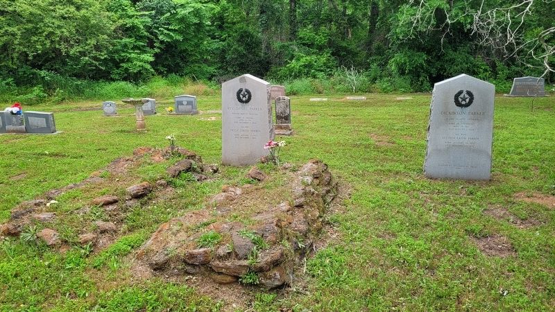
On Farm to Market Road 861, 0.2 miles north of County Road 103, on the left when traveling north.
A Soldier in the Army of Texas, 1836
Born in Indiana July 26, 1816 Died November 24, 1849
His Wife Laura Jordon Bennett
Born August 28, 1830 Died December 24, 1925 — — Map (db m245833) WM
On Farm to Market Road 861, 0.2 miles north of County Road 103, on the left when traveling north.
Pioneer Baptist Minister
Born in Virginia
April 6, 1781 Died December 3, 1844
His Wife Patsy Dixon Parker
Born January 17, 1783 Died December 1, 1846 — — Map (db m245830) WM
Near Hagy Drive, 0.1 miles east of Charlotte Avenue, on the left when traveling east.
Irish immigrant James W. Byrne (1787 – 1865), a veteran of the Texas Revolution, was an early settler of this area. He established the town of Lamar and with his wife Harriet, sold land on Aransas Bay to the Catholic Church for a chapel site. . . . — — Map (db m53717) HM
On U.S. 82 Frontage Road at Business U.S. 277, on the right when traveling east on U.S. 82.
Born Hollidaysburg, Pennsylvania; came to Texas about 1835, joined Texian Army, and was one of 24 survivors of the Goliad Massacre, March 27, 1836. Joined Texian-Santa Fe Expedition, and en route to New Mexico, Aug. 4, 1841, carved his name on a . . . — — Map (db m187196) HM
On Farm to Market Road 1333 at Curvier Road, on the left when traveling south on Route 1333.
This land had once been allocated in the 1700s as a ranch for Mission San Jose in San Antonio (20 mi. N), but in the 1820s was left unsettled. In 1828 prominent San Antonio resident Jose Antonio Navarro (1795-1871) beseeched the Governor of the . . . — — Map (db m111187) HM
On West Main Street (State Highway 36) at Nelsonville Road (State Highway 159), in the median on West Main Street.
A part of the grant to
Stephen F. Austin in 1821
Created a municipality under the
Mexican government in 1828
Became a county of the
Republic of Texas, March 17, 1836
Named in honor of
Stephen Fuller Austin, 1793-1836
Pioneer . . . — — Map (db m125601) HM
On South Masonic Street at West Lewis Street, on the left when traveling north on South Masonic Street.
The heritage of Bellville Methodist Church dates to 1822, when Thomas B. Bell came to Texas from Florida with Stephen F. Austin's Old Three Hundred colonists. He settled in an area west of the Brazos River, and donated fifty acres of land . . . — — Map (db m157592) HM
On Farm to Market Road 1094 at Swearingen Road, on the right when traveling west on Highway 1094.
Austin County pioneer and Texas War for Independence veteran, Elemelech Swearingen, was born in Shepherdsville Kentucky (Bullitt Co.) in 1805. He married Angelina Weeks (1811-1883) in 1827 and in 1831, moved with his family to Texas. The Swearingens . . . — — Map (db m202526) HM
On SH 159 (State Highway 159) at Hofheinz Road, on the left when traveling west on SH 159.
In Jan. 1831 Charles Fordtran, a German of Huguenot descent, joined the colony of Stephen F. Austin. His first work was to survey land for Austin's partner, Samuel May Williams. He was given a league (4,428.4 acres) as his fee. Soon he brought in . . . — — Map (db m146168) HM
On Schroeder Road, 0.2 miles Ernst Parkway (Farm to Market Road 109), on the right when traveling west.
Christian Friedrich Ernst (Dirks) was born in Germany in 1796. Friedrich Ernst was inducted into the German Army in 1814 and served for five years. He married Louise Gesine Auguste Weber in 1819. They became the parents of Caroline, John . . . — — Map (db m165425) HM
On Schroeder Road, 0.2 miles west of Ernst Parkway (Farm to Market Road 109), on the left when traveling west.
A native of Oldenburg, Germany, John Friedrich Ernst (1820-1863) emigrated to the United States with his family at the age of nine. In 1831, they traveled from New York City to Texas, finally arriving in what is now the town of Industry. The . . . — — Map (db m165424) HM
On Dandelion Lane, 0.1 miles west of Hall Road, on the right when traveling west.
Founded by the Concord Christian Church in 1870, Concord Cemetery (also known as the Concord Church Cemetery) sits on 3.4 acres of land in northern Austin County and is part of the Concord Christian Church. The earliest known grave is that of Dr. . . . — — Map (db m202580) HM
On Old Highway 36 at Albert Road, on the left when traveling south on Old Highway 36.
A native of Circleville Ohio, J.B. Pier came to Texas in 1835 with his wife Lucy (Merry). The Piers settled in this area near the site of the early Texas town of Travis. Pier served as a member of the Texas Army during the War for Independence. He . . . — — Map (db m202586) HM
On Hall Road at Daylily Street, on the left when traveling west on Hall Road.
One of great pioneer Methodist ministers of Texas. Pennsylvania - born. He began preaching at age 19. In 1833 he came to Texas and soon settled in this county. Unkempt in appearance, Kenney redeemed his eccentricity with an eloquent style of . . . — — Map (db m202581) HM
Ideally Situated Close to Commerce Square and the Brazos River, these two lots were near the center of town. Like many San Felipe lots, the property changed hands several times. First developed by the Calvit family, its last owner was Almyra . . . — — Map (db m206287) HM
Near Farm to Market 1458, 0.2 miles 2nd Street, on the left when traveling north.
Near this site stood
A Town Hall
Built about 1830
in which were held
the First and Second Conventions
of Texas, 1832 and 1833,
and the Consultation of 1835
the provisional government functioned
here until March 2, 1836, when . . . — — Map (db m43759) HM
Stephen F. Austin hoped his colony in Texas would help his family prosper. But the business of
being an empresario proved financially disappointing. Hoping a family business - like a store - would generate income, Austin encouraged his . . . — — Map (db m206267) HM
Near Farm to Market Road 1458, 0.1 miles north of Park Road 38.
Austin's land office and its agents set about carving civilization out of the untamed Texas wilderness. Mapping and surveying land at a whirlwind pace, Austin's office issued nearly 1500 land grants to settlers in Mexican Texas between 1823 and . . . — — Map (db m201786) HM
Downtown San Felipe was the center of the colony, but its farms and ranches fed settlers and generated profits that helped the colony thrive. Farm plots, or labors, measuring 177 acres each spread outward from town - many along waterways, which . . . — — Map (db m206323) HM
San Felipe's First Townsfolk Arrived to find the "town" yet to be built. Many raised their houses, kitchens and stables with their own hands.
Austin also enlisted skilled housewrights (house builders), sawyers, teamsters and blacksmiths to . . . — — Map (db m206316) HM
As the Number of Permanent Residents in San Felipe grew, a business district developed west of Commerce Square. Merchants, including Nathaniel Townsend and George Huff, supplied shoppers with goods from around the world. Tailors cut clothes to . . . — — Map (db m206271) HM
Stocked With Goods From Cincinnati, Nicholas Clopper's store in San Felipe opened in 1826. Clopper faced the challenges of all merchants on the frontier. The town was "in a state of infancy" and home to only nine families of resident customers. . . . — — Map (db m206272) HM
Godwin B. Cotten tried printing in Alabama, Louisiana and Tamaulipas, Mexico, before setting out The Texas Gazette and the first book published in Texas: Translation of the Laws, Orders, and Contracts, on Colonization.
Cotten . . . — — Map (db m206260) HM
On Farm to Market 1458, 0.2 miles north of 2nd Street, on the left when traveling north.
During the mid-1820's, When Stephen F. Austin was founding this town, the only roads in the area were wagon ruts or beaten trails marked by notched trees. Within a decade, however, the village of San Felipe, one of the first Anglo settlements in . . . — — Map (db m43718) HM
With his Empresario contract in hand, Stephen F. Austin searched out a suitable location for the "capital" of his colony. Together with surveyors and guides, Austin selected a site where a ferry crossed the Brazos River. By late October . . . — — Map (db m206331) HM
In the Town's Early Years, Empresario Stephen F. Austin filled many roles. Administrator of land grants and court judge, Austin also coordinated with Mexican government officials. He managed the growing town, and as colonel of the . . . — — Map (db m206275) HM
On Park Road 38, 0.1 miles east of Antonio Martinez Street, on the right when traveling west.
The first known person to occupy the land where the Hill House is located was Judge Robert M. "Three Legged Willie" Williamson. During his ownership, the community of San Felipe de Austin was burned to the ground by order of Moseley Baker, a . . . — — Map (db m202605) HM
Near Farm to Market 1458, 0.2 miles north of 2nd Street, on the left when traveling north.
Built by John Crutcher in 1847 on the Plaza de Commercio in San Felipe, this was the last store built in the town after its 1836 burning by military order. Purchased in 1867 by Dr. J.J. Josey, it was in continuous operation as a store until 1942. . . . — — Map (db m43760) HM
Jane Wilkins and her family were among the Colony's earliest immigrants and the first to
settle what is now the City of Houston. By 1827, Wilkins and her two daughters, Jane and Mary, had made a home in San Felipe. They also received a league . . . — — Map (db m206262) HM
Near Farm to Market 1458, 0.2 miles north of 2nd Street, on the left when traveling north.
In memory of
John Bricker
a private in Captain Mosley Baker’s
company, who was killed just
across the river from this site
April 7th 1836 by a shot from a
Mexican cannon, and was buried
where he fell. He was born in
Cumberland . . . — — Map (db m43758) HM
Near Farm to Market Road 1458, 0.1 miles north of Park Road 38.
Beginning in the 1920s local leaders looked for ways to commemorate this important colonial Texas history site. After 15 years planning and developing the property for its transition to the State in 1940, local supporters created a Friends . . . — — Map (db m201789) HM
Empresario Stephen F. Austin Considered several sites for his colony's headquarters, but this location on the Brazos River had a convenient advantage. A ferry, operated by an early settler named John McFarland, took travelers on the . . . — — Map (db m206274) HM
On Farm to Market Road 1458, 0.2 miles north of Interstate 10, on the right when traveling north.
First Anglo-American capital of Texas. Came into being on July 26, 1828, as capital of the Austin Colony, by decree of the Mexican government. Father of Texas Stephen F. Austin had begun under the 1821 grant from Mexico the settlement of more than . . . — — Map (db m116924) HM
On Farm to Market Road 1458, 0.1 miles north of Park Road 38, on the left when traveling north.
[Side 1] San Felipe de Austin Town Site laid off by Stephen F. Austin as the Capital of his Colony in 1824 Here was held the only Federal District Court ever convened in Texas under Mexican rule
[Side 2]
Events leading to Revolution, First . . . — — Map (db m163048) HM
A neighborhood on the east edge of town was home to a number of Tejanos, or native born Texans. The cluster of families was referred to as Spanish Town.
Some families had been driven from their homes during Mexico's war for independence . . . — — Map (db m206325) HM
Near Farm to Market Road 1458, 0.1 miles north of Park Road 38.
Between 1821 and 1835, Austin shaped the course of colonial Texas. Here, he built his only home in Texas. His log cabin also served as the colony's land office, and became the center of San Felipe commerce.
Following a plan begun by his . . . — — Map (db m201785) HM
On Farm to Market 1458, 0.2 miles 2nd Street, on the left when traveling north. Reported missing.
Replica of
Stephen F. Austin's Cabin
This structure is a replica of the only Texas home of Stephen F. Austin, “Father of Texas.” The chimney contains bricks from original (1828) cabin. Other materials were made as . . . — — Map (db m156552) HM
Near Farm to Market Road 1458, 0.1 miles north of Park Road 38.
After the fall of the Alamo on March 6th, 1836 General Sam Houston and his Texian volunteers retreated to the east from Gonzales. Colonists evacuated and abandoned their homes and property in what became known as the Runaway Scrape.
Local . . . — — Map (db m201788) HM
Near Farm to Market Road 1458, 0.1 miles north of Park Road 38.
The Convention of 1833, followed by the Consultation in 1835, reflected the growing tension between the colonists and the Mexican government. The fateful military and political events of late 1835, would sway Austin to the war movement. . . . — — Map (db m201787) HM
William Barret Travis is remembered as a revolutionary patriot and martyr of the Alamo. Before he gave his life for Texas' independence, he was a young attorney in San Felipe who ran a law office located on lot 50.
Travis represented his . . . — — Map (db m206178) HM
Near Farm to Market Road 1458, 0.1 miles north of Park Road 38.
Between 1823 and 1836, San Felipe de Austin was the focal point for issues related to the immigration and settlement of American colonists in Mexican-controlled Texas.
This site marks the central business district of San Felipe de Austin . . . — — Map (db m201784) HM
On 36th Division Memorial Highway (State Highway 36) at Johnston Road, on the right when traveling south on 36th Division Memorial Highway.
As a young man Martin Allen assisted his father, Benjamin, in surveying roads in their native state of Kentucky. He married Elizabeth Vice in 1804 and by 1810 they and their three children were living in Louisiana.
Martin joined the . . . — — Map (db m61299) HM
On Old Medina Highway, 0.1 miles west of Houston Street, on the right when traveling west.
Freedman and soldier Hendrick Arnold (1804-1849) was awarded land following the Texas Revolution for his participation in the Siege of Bexar and the Battle of San Jacinto. He received six surveys in what was then Bexar county, including this . . . — — Map (db m201897) HM
On Pecan Street north of Walnut Street, on the right when traveling south.
Chosen commissary by
General Andrew Jackson, War of 1812
Edward Burleson, his son,
accompanied him as book-keeper
Participated in
the Battle of New Orleans
January 8, 1815
Served under
his son, Edward, Army of Texas,
in the Grass . . . — — Map (db m111111) HM
On Loop State Highway 150 at Park Road 1, on the right when traveling west on State Highway 150.
Long before white men arrived, this region was inhabited by Tonkawa and Comanche Indians. In 1691 the first Spanish explorers crossed this territory en route to east Texas. From their route, parts of “El Camino Real” (the King's . . . — — Map (db m126751) HM
On Park Road 1-A, 0.6 miles east of Loop Texas Highway 150 when traveling east.
Erected in recognition of the
distinguished service to Texas of
Felipe Entrique Neri,
Baron De Bastrop
1770 - 1829
Pioneer Red River empresario. Land commissioner of Austin's colony. Member of the Congress of Coahuila and Texas. In . . . — — Map (db m111113) HM
Near State Highway 95, 0.1 miles north of Farm Street.
Army of Texas • Participated in the Capture of Goliad October 9, 1835 • Signer of the Goliad Declaration of Independence • Born in Tennessee, 1810 • Died 1849 — — Map (db m195970) HM
On Farm to Market Road 20, 0.1 miles north of Humble Lane (County Highway 232), on the right when traveling north.
Early land grantee in this area. Of Dutch descent, he was born in Virginia. Came to Texas (then part of Mexico) in 1831 as a colonist of Stephen F. Austin, the "Father of Texas."
Received a Spanish league of land (4,444 acres) here. Active in . . . — — Map (db m118406) HM
On Walnut Street at Hill Street, on the right when traveling west on Walnut Street.
Thomas H. Mays was born in 1802 in Virginia and emigrated to Texas from Tennessee in 1830. In 1834, he became Bastrop's first municipal surveyor and platted the city's new streets. Two years later, he was wounded in the leg at the Battle of San . . . — — Map (db m65221) HM
On Farm to Market Road 969, 0.2 miles west of Upper Elgin River Road (County Route 127), on the right when traveling east.
Signer of the Texas
Declaration of Independence
Aide-de-camp to Gen. Houston at
San Jacinto
Commander of a regiment of Rangers
1836-37
Here his widow
Mrs. Elizabeth Coleman
and son, Albert V. Coleman
were killed by Indians
and . . . — — Map (db m82688) HM
Near Jeddo Road (County Highway 297) 0.2 miles north of Farm to Market Road 713.
Born April 24, 1806 Came to Texas in 1835. A soldier in the Texas War for Independence before and during the Siege of Bexar 1835 and participated in the Battle of San Jacinto 1836 Died April 6, 1870 His wife Louranie Darling Born June 10, 1810 . . . — — Map (db m180695) HM
On Waco Street at Old Highway 20 (Farm to Market Road 333), on the left when traveling east on Waco Street.
Born in Tennessee, friend of David Crockett, Jesse Billingsley came to Texas in 1834. Known as a fearless Indian fighter, Billingsley was elected captain of the Mina Volunteers, Company C, of the Republic of Texas Army. At the Battle of San Jacinto, . . . — — Map (db m205479) HM
On Farm to Market Road 2571 at Young School House Road (County Road 280), on the right when traveling west on Road 2571.
Maryland native Stephen Scallorn (1787-1887) lived in Kentucky and Tennessee, where he practiced medicine and was active in the Primitive Baptist Church, before moving to Texas. He was attracted to the Republic by the favorable accounts of his . . . — — Map (db m160302) HM
Built in 1890 by Will H. and Julia George of materials from early house on land inherited from her father, Maj. J.H. Wood (Texas Cattle Empire Builder) who came from New York to join Texas War for Independence. Remodeled in 1900, house is raised . . . — — Map (db m207402) HM
Named by the Spaniards about 1800 because of its midway position between the San Antonio and Nueces Rivers. Rises in Karnes County; empties into Mission River. Crossed by explorers, padres, soldiers, settlers who traveled on three early ox-cart . . . — — Map (db m202009) HM
On East Avenue E east of South Penelope Street, on the left when traveling west.
Widow of William Hardin
before her marriage to
Dr. O.P. Kelton
Many of the Mexican officers
and men were placed in the
care of Judge and Mrs. Hardin
after the victory at San Jacinto
and were mercifully treated by them.
Born August . . . — — Map (db m152194) HM
Near North Main Street (State Highway 317) north of East 15th Avenue, on the left when traveling north.
Texas revolutionary veteran and local merchant Norman Austin made important contributions to his adopted state. Born in Skaneateles, New York, he was the fifth son of a large family and traveled widely throughout his life. He farmed in Michigan and . . . — — Map (db m152240) HM
A native of South Carolina, Wilson Van Dyke served as a member of the Somervell Expedition, which was organized in 1842 to expel the Mexican Army from Texas. Under command of Col. W.S. Fisher, he crossed the Rio Grande and was captured. A survivor . . . — — Map (db m29382) HM
On South Main Street (Farm to Market Road 2268) at College Hill Drive, on the right when traveling north on South Main Street.
Elijah Sterling Clack Robertson was born in Giles County, Tennessee, August 23, 1820. His father, Empresario S.C. Robertson, brought him to Texas to learn Spanish and to help him in his land office translating and copying land grants to Spanish. For . . . — — Map (db m212459) HM
Near South Main Street (Farm to Market Road 2268) at College Hill Drive, on the right when traveling north.
Under the sheltering trees on this hill, Mary E. Robertson and Thomas S. Sutherland met and studied at Thomas Arnold High School graduating in 1906 and 1910, married in the Robertson Homeplace uniting two families whose ancestors settled in Texas . . . — — Map (db m212453) HM
These iron 4 pound cannon replicas are based on the measurements of the cannons recovered in 1852 by Samuel Maverick near the northwest corner of the Alamo. Archival research indicates that these cannons were on site but not in use during the Battle . . . — — Map (db m188609) HM
Near Alamo Plaza, 0.1 miles south of East Houston Street.
As the granddaughter of Lorenzo de Zavala (1789-1836), first vice-president of the Republic of Texas, young Adina de Zavala was exposed to vivid accounts of Texas' revolutionary and republican past. She became a guiding force in the preservation . . . — — Map (db m61083) HM
On Alamo Plaza, on the right when traveling north.
Mission San Antonio de Valero, established nearby in 1718, was relocated here in 1724. By 1762, the mission plaza was enclosed by thick stone and adobe walls. The 11x14-foot main gateway was located at this site along the south wall. In 1803 . . . — — Map (db m30713) HM
March 6, 1836 - - - - March 6, 1986
Commemorating the sesquicentennial of the Battle of
the Alamo by the Daughters of the Republic of Texas
"I shall never surrender or retreat. Then, I call on you in the name of liberty, of patriotism . . . — — Map (db m232293) WM
At this location an exciting discovery was made. Approximately two feet below the current surface archaeologist recently uncovered a circular stone platform - but what is it?
Alamo archaeologist Kristi Nichols explains, "It appears to be . . . — — Map (db m188522) HM
On Alamo Plaza at East Crockett Street, on the right on Alamo Plaza.
By 1835, tensions between those in Mexico who supported republican ideals and the centralist Mexican government had escalated into all-out war. Seeking their independence, Texan revolutionaries won the town of San Antonio de Béxar from . . . — — Map (db m188616) HM
Spanish soldiers saved this 18th-century cannon from a shipwreck in Matagorda Bay located off the Texas coast in 1817. It was brought to San Antonio where it was later captured by Texian forces during the Battle of Béxar (1835). The following year, . . . — — Map (db m188593) HM
On Alamo Plaza at East Crockett Street on Alamo Plaza.
Typical of the type of cannon purchased by merchants during the 18th century to guard ports and ships, this 4 pounder was cast in Great Britain sometime after 1725. It was used by the Texans during the 1836 Battle of the Alamo. Once Texas won its . . . — — Map (db m227651) HM
On Alamo Plaza at East Crockett Street on Alamo Plaza.
Characteristics of this light cast-iron cannon are similar to ones produced in Sweden for the commercial market in the 18th century. Any distinguishing maker marks have been lost. It likely came to Texas through trade, capture, or purchase. Found . . . — — Map (db m227658) HM
On Alamo Plaza at East Crockett Street on Alamo Plaza.
Characteristics of this light cast-iron cannon are similar to French patterns produced for the commercial market during the late 18th century. It likely came to Texas through trade, capture, or purchase. It was found in 1852 by workman digging in a . . . — — Map (db m227659) HM
Title to the Alamo Mission property,
acquired through her efforts and
her personal fortune, was conveyed by
Clara Driscoll
to the State of Texas, Sept. 5th 1905:
“That the sacred shrine be saved from the
encroachments of . . . — — Map (db m30734) HM
Whereas: The memory of Clara Driscoll will be immortal in the hearts of the Daughters of the Republic of Texas for the patriotic work which held her great interest, from her girlhood through her life.
Whereas: Clara Driscoll is known throughout . . . — — Map (db m232679) HM
(Born August 1, 1809) sacrificed his life for Texas liberty while defending the north wall of the Alamo in the vicinity of the present day federal building (across Houston) on March 6, 1836. — — Map (db m188587) HM
David Crockett was a frontiersman who became a well-known politician and humorist in early 19th Century America. In a period of history that celebrated the rise of the common man, no common man rose higher from such humble beginnings. "Davy" . . . — — Map (db m188527) HM
On Alamo Plaza at East Crockett Street on Alamo Plaza.
In 1836, an 18-pounder cannon similar to the one seen here was mounted to defend the Alamo's southwest corner. The 18-pounder played a legendary role in the prelude to the battle. After a brief parlay, the Alamo's commanding officer Lt. . . . — — Map (db m188611) HM
On Alamo Plaza at East Crockett Street on Alamo Plaza.
25 years ago, engineers tried to block rising damp by pushing a special plate made of corrosion-resistant alloy through the Alamo Church's foundations. Today's excavations here will tell preservation architects how well this metal plate, called a . . . — — Map (db m227628) HM
All great nations have creation myths, the Republic of Texas was no different. Born in New Haven, Connecticut, Emily D. West was a free woman of mixed race. In 1835, she signed a one-year contract in New York City agreeing to work as a housekeeper . . . — — Map (db m232623) HM WM
The San Antonio de Padua Mission was founded in San Antonio in 1716 by the Franciscan Father, Antonio Olivares, and after merging with the San Francisco Solano Mission in 1718, it was officially founded as the San Antonio de Valero Mission. The . . . — — Map (db m9228) HM
The Treaty of Velasco mandated that all Mexican forces withdraw south of the Rio Grande. Before leaving the Alamo, however, Mexican troops destroyed much of what remained. For many years, the structure stood deserted as the affairs of the new . . . — — Map (db m188747) HM
As the twentieth century approached, the historic Alamo Shrine was surrounded by commercial property, and original parts of the mission were in danger of being lost forever. Adina De Zavala, granddaughter of the first vice president of the Republic . . . — — Map (db m188760) HM
Erected in grateful recognition of
the supreme act of heroism of the
thirty two men from Gonzales
who gave their lives in the Alamo
in response to the appeal of Travis.
Erected March 1, 1936 — — Map (db m30777) HM
On Alamo Plaza at East Houston Street on Alamo Plaza.
Hendrick Arnold, a free man of mixed race, emigrated from Mississippi in 1826, settling with his parents in Austin's Colony on the Brazos River. He played a key role in the Texas Revolution as a guide and spy for the Texian Army.
By 1835, . . . — — Map (db m232678) HM WM
This oak tree planted in the spring of 1965 in memory of the Heroes of the Alamo. Presented by the First Officers' Training Camp Association of Texas, Leon Springs, Texas, May 8...August 15, 1917. Roster of First Campers filed in Alamo Library. — — Map (db m30599) HM
On Alamo Plaza at East Commerce Street on Alamo Plaza.
Survivors Juana Navarro Perez Alsbury and son Alejo Perez, Jr. Bettie Dolores Cervantes Susanna Dickinson (Wife of Almeron Dickinson who died in the Alamo) and daughter Angelina Dickinson Ana Salazar Castro Esparza (Wife of Gregorio Esparza . . . — — Map (db m227737) WM
James Bowie represented the fluid nature of the frontier, born in Kentucky but living in Missouri and Louisiana before finally settling in Texas. Along the way, he gained a reputation as a deadly duelist with a knife.
Bowie traveled to Texas . . . — — Map (db m188534) HM
To the Memory of
The Heroes of the Alamo
[Poem in Chinese follows]
Japanese Monument
The story of the Alamo reaches far beyond the borders of Texas. More than 2.6 million visitors from around the world came to the Alamo in 1996. The . . . — — Map (db m30779) HM
On Alamo Plaza at East Houston Street on Alamo Plaza.
Virginia-born John William Smith gained fame for the role he played in early Texas history. Smith, nicknamed "El Colorado" for his red hair, arrived in Texas in 1827 and settled in San Antonio de Béxar. He became fluent in Spanish, moving easily . . . — — Map (db m188529) HM
Born to a prominent San Antonio family, Juan Nepomuceno Seguín led a life of service to his community. He was both a solider and politician, becoming Mayor of San Antonio in 1841.
During the Texas Revolution, Seguín supported independence. He . . . — — Map (db m188526) HM
Commandancy of the Alamo -
Bexar, Feby. 24th, 1836 -
To the people of Texas & all Americans in the world --
Fellow citizens and compatriots
I am besieged, by a thousand or more of the Mexicans and Santa Anna - I have sustained a . . . — — Map (db m78329) HM
Near Alamo Plaza north of East Crockett Street, on the right when traveling north.
Legend states that in 1836 Lt. Col. William Barret Travis unsheathed his sword and
drew a line on this ground before his battle-weary men stating: “Those prepared to
give their lives in Freedom’s cause, come over to me!” — — Map (db m123951) HM
907 entries matched your criteria. The first 100 are listed above. Next 100 ⊳