Marker Logo HMdb.org THE HISTORICAL
MARKER DATABASE
“Bite-Size Bits of Local, National, and Global History”


After filtering for North Carolina, 763 entries match your criteria. Entries 101 through 200 are listed. ⊲ Previous 100Next 100 


Industry & Commerce Topic

 
Wide view of the Red Hill Marker image, Touch for more information
By Paul Crumlish, May 6, 2011
Wide view of the Red Hill Marker
101 North Carolina, Cabarrus County, Concord — L-84 — Red Hill
On Concord Parkway N (Bypass U.S. 29) at McGill Avenue NW, on the right when traveling north on Concord Parkway N.
Home and tavern of John & Martin Pheifer. Gov. Wm. Tryon and President George Washington among guests. Stood 1½ mi. W.Map (db m42865) HM
102 North Carolina, Cabarrus County, Concord — 1 — Red Hill Tavern
On Union Street South just north of Means Avenue Southeast, on the right when traveling south.
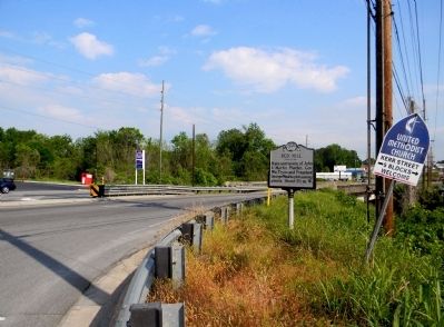
Red Hill Tavern was home to Martin Pheifer, Jr. Mr. Pheifer was a good friend of George Washington, having served with him at Valley Forge. For that reason President Washington was a private guest of Pheifer during his Southern Tour, dining and . . . Map (db m175756) HM
103 North Carolina, Cabarrus County, Concord — The Odell House288 Union Street North
On Union Street North at Buffalo Avenue Northwest, on the right when traveling north on Union Street North.
has been placed on the National Register of Historic Places by the United States Department of the Interior c. 1881Map (db m238078) HM
104 North Carolina, Cabarrus County, Concord — L-33 — Trading Path
On Union Street South at McAllister Avenue Southeast, on the right when traveling north on Union Street South.
Colonial trading route started in 17th century; extended from southern Va. to land of Catawba & Waxhaw Indians in N.C. Passed near this spot.Map (db m175745) HM
105 North Carolina, Cabarrus County, Concord — L-50 — W. R. Odell
On Church Street NE (U.S. 601) at Buffalo Street NW, on the right when traveling north on Church Street NE.
Textile manufacturer, State Senator, 1905-07. Friend of education. His home is 1 block W.Map (db m42738) HM
106 North Carolina, Cabarrus County, Concord — L-91 — Warren Coleman1849-1904
On Warren C. Coleman Boulevard (Bypass U.S. 601) at Main Street SW, on the right when traveling west on Warren C. Coleman Boulevard.
Founder of the nation's first textile factory owned and operated by blacks, 1897-1904. Mill building is 350 yds. N.Map (db m43382) HM
107 North Carolina, Cabarrus County, Kannapolis — L-55 — James W. Cannon1852-1921
On South Cannon Boulevard (U.S. 29) at Cloverleaf Plaza, on the right when traveling north on South Cannon Boulevard.
Textile pioneer; founder of Cannon Mills, 1887, and Kannapolis, 1906; leading manufacturer of towels. Grave 2 mi. S.Map (db m42692) HM
108 North Carolina, Cabarrus County, Midland — L-7 — Reed Gold Mine
On North Carolina Route 24/27 at Reed Mine Road, on the right when traveling west on State Route 24/27.
Gold discovered there 1799. Many gold mines were later operated in this area. N.C. was the chief gold-mining state to 1849. N. 4 mi.Map (db m40479) HM
Paid Advertisement
109 North Carolina, Cabarrus County, Mount Pleasant — Mount Pleasant Mercantile/Mount Pleasant Hosiery Millcirca 1911/1932-2008
On North Main Street at East Franklin Street (North Carolina Highway 73), on the right when traveling north on North Main Street.
contributes to the Mount Pleasant Historic District placed on the National Register of Historic Places by the United States Department of the Interior 1986Map (db m238004) HM
110 North Carolina, Caldwell County, Lenoir — Belk's Department Store101 Main Street
On North Main Street just north of Harper Avenue, on the left when traveling north.
has been placed on the National Register of Historic Places by the United States Department of the Interior 1928Map (db m208198) HM
111 North Carolina, Camden County, Camden — Locks of the Dismal Swamp Canal
On State Highway 343, 0.1 miles north of Plank Bridge Road, on the right when traveling south.
Colonel William Byrd II proposed digging a series of ditches and a channel through the Dismal Swamp in 1728. Construction began on the Dismal Swamp Canal in 1793, after the North Carolina and Virginia General Assemblies passed similar acts for . . . Map (db m165196) HM
112 North Carolina, Camden County, Camden, South Hills — Dismal Swamp Canal2362 Highway 17
On McPherson Road (State Highway 1231) 0.1 miles west of U.S. 17, on the right when traveling south.
Dismal Swamp Canal c. 1805 Has Been Placed on The National Register of Historic Places [Additional block to the right:] National Historic Civil Engineering Landmark The Dismal Swamp Canal Designated . . . Map (db m165189) HM
113 North Carolina, Camden County, South Mills — A-12 — Dismal Swamp Canal
On Mullen Street north of Main Street (U.S. 17), on the left when traveling north.
Connects Albemarle Sound with Chesapeake Bay. Begun 1790; in use by War of 1812.Map (db m56763) HM
114 North Carolina, Carteret County, Beaufort — Menhaden Fishermen MonumentThe Beaufort Fisherman
On Frontage Street (Front Street) near Gordon Street (Local Highway 1312), on the right when traveling west.
In loving memory and recognition Menhaden Fishermen Past — Present — Future This is their livelihood, this is their life — they know the sea, can read God’s weather chart: sun, moon, and stars from memory. The compass points are there . . . Map (db m226093) HM
115 North Carolina, Carteret County, Beaufort — C-21 — Whale Fishery
On Turner Street, 0.1 miles south of Cedar Street (U.S. 70), on the right when traveling north.
At Shackleford Banks, six miles southeast by boat, was located a whale fishery of the 18th and 19th centuries.Map (db m67560) HM
116 North Carolina, Carteret County, Cedar Island — C-4 — Ocracoke Inlet
On Cedar Island Road (North Carolina Route 12) north of Sound View Drive, on the left when traveling south.
Once chief trade inlet of N.C. In 1718 pirate "Blackbeard" was killed near there, 17 mi. N.E., across Pamlico Sound.Map (db m226097) HM
117 North Carolina, Carteret County, Morehead City — C-49 — Confederate Salt Works
On Port Terminal Road at South 3rd Street, on the right when traveling east on Port Terminal Road.
The largest Confederate salt works in Carteret County was 50 yards S. It was burned by Union forces in April, 1862.Map (db m77041) HM
Paid Advertisement
118 North Carolina, Carteret County, Morehead City — C-48 — N.C. Bankers Association
On Arendell Street (U.S. 70) west of South 4th Street, on the right when traveling east.
Organized at Teachers' Assembly Hall, nearby, July 24, 1897. Thomas Battle, first president.Map (db m225766) HM
119 North Carolina, Carteret County, Morehead City — C-48 — North Carolina Bankers Association
On Arendel Street (U.S. 70) at 4th Street, on the right when traveling east on Arendel Street. Reported missing.
Organized at Teacher's Assembly Hall, July 24, 1897. Thomas H. Battle elected first president.Map (db m77013) HM
120 North Carolina, Carteret County, Otway — Welcome to Otway… — Outer Banks National Scenic Byway —
On U.S. 70 at Otway Farm Road, on the right when traveling east on U.S. 70.
Otway’s first residents migrated northward from the Straits area in the 1700s. The rich farmland and access to water teeming with fish, crabs, and oysters made it desirable for homesteading. A 1932 Beaufort newspaper recounts a fall ritual . . . Map (db m212875) HM
121 North Carolina, Carteret County, Stacy — Welcome to Stacy… — Outer Banks National Scenic Byway —
On U.S. 70 north of Emilee Lane, on the left when traveling south.
The first deeded property was in 1752 to William Salter. The early settlers called this area, Piney Point, for the piece of wooded land which jutted out into Core Sound and served as a navigational day mark. With the establishment of the post office . . . Map (db m212872) HM
122 North Carolina, Carteret County, Williston — Welcome to Williston… — Outer Banks National Scenic Byway —
On U.S. 70 north of Donnie Davis Road, on the right when traveling south.
Williston’s first settlers came in 1723. Life was self-sustaining with no large industry until 200 years later when the Willis Brothers Seafood Company was formed. This clam, scallop and fish house became the main employer for Williston and . . . Map (db m212874) HM
123 North Carolina, Caswell County, Milton — Clay-Lewis-Irvine Housec. 1815
On Fairview Drive just north of Broad Street (State Highway 57), on the right when traveling north.
Built by Henry M. Clay, local mill owner, in the Federal style. Nicholas Meriwether Lewis purchased the home in 1830 and added the Greek Revival front portico and a parlor mantle and trim from the Thomas Day workshop. The large boxwoods were part of . . . Map (db m171792) HM
124 North Carolina, Caswell County, Milton — Commercial Row Eastearly - to mid - 19th century — → —
On North Carolina 57 (State Highway 57) just east of Leas Street, on the left when traveling east.
5. F.B. Jones General Merchandise Purchased from the estate of Thomas James Jones, tinsmith, his father. There is a working elevator in the rear from early 20th century. 6. Bowers Butcher Shop Also owned by F.B. Jones and used as . . . Map (db m220875) HM
125 North Carolina, Caswell County, Milton — Commercial Row Westearly - to mid - 19th century — ← —
On Broad Street (State Highway 57) just east of Leas Street, on the right when traveling west.
1. W.S. Brandon General Merchandise Last merchant was Dudley Brandon. The building was an early silent movie theater. 2. Lewis Walker Drugstore Beautiful brown granite counters. 3. W.T. Oliver General Merchandise . . . Map (db m220876) HM
126 North Carolina, Caswell County, Milton — Melvillec. 1835
On Broad Street (State Highway 57) just west of Liberty Street, on the right when traveling west.
A Federal style house with emerging Greek Revival form built by John Wilson, merchant and planter. The interior contains late Federal trim from the Thomas Day workshop. The original brick kitchen and frame smoke house are in the rear. A later owner . . . Map (db m171779) HM
Paid Advertisement
127 North Carolina, Caswell County, Milton — Milton Batteaux, Boatmen, Hogsheads and Coopers
On Broad Street (Highway 57) just east of Liberty Street, on the right when traveling west.
Barrels called Hogsheads were "prized," or filled, with tobacco or flour, rolled down to the Dan River and shipped on "Batteaux," which were flat-bottomed boats. Men who made hogsheads were called "Coopers." This display is in honor of William . . . Map (db m171776) HM
128 North Carolina, Caswell County, Milton — Milton General Storec. 1830
On Broad Street (State Highway 57) at Liberty Street, on the right when traveling west on Broad Street.
First built as Watkins Dry Goods Store where clothing could be purchased. There was also a school room and you could buy books. Bought by Walter Lea Thomas in 1910 and operated by him and his sons as a general merchandise store and a post office . . . Map (db m220873) HM
129 North Carolina, Caswell County, Milton — Milton State Bankca. 1860
On Broad Street (Highway 57) east of Liberty Street, on the right when traveling west.
Built by Dabney Cosby, construction protégé of Thomas Jefferson. Served as a banking house and staff residence for 49 years, later Milton Post Office for 51 years, and thereafter a private resident. Listed in the National Register of Historic Places . . . Map (db m171775) HM
130 North Carolina, Caswell County, Milton — Patterson-Dodson Housec. 1850
On Academy Street (State Highway 62) just south of Broad Street (State Highway 62), on the right when traveling south.
Queen Anne and Victorian style home built by David Patterson, a dry goods merchant from Ireland. Later home and office of noted physicians Dr. Charles Dodson and son, Dr. Henry Dodson who together provided medical care to the community from mid to . . . Map (db m171784) HM
131 North Carolina, Caswell County, Milton — Site of Milton Hotelc. 1825
On Broad Street (State Highway 45) at Leas Street, on the left when traveling west on Broad Street.
The 20 room brick and wood Milton Hotel was a local landmark and the center of area social activity for over a century. During its life the hotel went by several names, including Gordon Hotel and Hotel Caswell. Originally a tavern on the stagecoach . . . Map (db m171773) HM
132 North Carolina, Caswell County, Milton — The Wooding PlaceCa 1840
On North Bridge Street, 0.1 miles south of Broad Street (State Highway 57), on the left when traveling south.
One of the four raised Greek Revival cottages built in Milton for local merchants. Built for John Wooding who operated the Milton brickyard. Italianate porch Flemish bond basement, exterior end chimneys, and gable ends. Some trim and porch details . . . Map (db m220878) HM
133 North Carolina, Caswell County, Milton — G-93 — Thomas Dayca. 1801-1861
On Broad Street (State Highway 57) east of Palmer's Alley, on the right when traveling east.
Free black cabinetmaker in Milton, 1824-1861. Home and shop located here in the old Union Tavern, 1848-1858.Map (db m216777) HM
134 North Carolina, Caswell County, Milton — Thomas Housec. 1916
On Broad Street (State Highway 57) just west of Liberty Street, on the right when traveling west.
On this lot was a 3 story brick building where the Burch family lived. On the first floor was a five and dime store and a one room school. It was bought by Walter Lea Thomas of Leasburg, torn down and rebuilt between 1914 and 1916 out of the . . . Map (db m171783) HM
135 North Carolina, Catawba County, Catawba — Town of CatawbaIncorporated 1893
On North Main Street (State Road 10) north of 1st Avenue Northwest, on the left when traveling north.
Depot built here at siding on Western North Carolina Railroad, 1859; village organized as Catawba Station, 1872; market center for locally produced tobacco and flour; incorporated as Town of Catawba in 1893; base for building nearby Lookout Shoals . . . Map (db m210418) HM
Paid Advertisement
136 North Carolina, Catawba County, Hickory — Cline-Wilfong-Rush House1912
On 3rd Avenue Northwest (State Road 1314) at 6th Street Northwest, on the left when traveling west on 3rd Avenue Northwest.
Oakwood Historic District National Register of Historic PlacesMap (db m240539) HM
137 North Carolina, Catawba County, Hickory — Connolly C. Gamble House1934
On 6th Street Northwest, 0.1 miles south of 6th Avenue Northwest, on the right when traveling south.
Oakwood Historic District National Register of Historic PlacesMap (db m240587) HM
138 North Carolina, Catawba County, Hickory — Edgar L. Fox Home1937
On 2nd Avenue Northwest east of 6th Street Northwest, on the right when traveling east.
Oakwood Historic District National Register of Historic PlacesMap (db m240516) HM
139 North Carolina, Catawba County, Hickory — Edgar Lee Flowers House1932
On 6th Street Northwest, 0.1 miles north of 4th Avenue Northwest, on the right when traveling north.
Oakwood Historic District National Register of Historic PlacesMap (db m240579) HM
140 North Carolina, Catawba County, Hickory — Edwin Umstead House1933
On 6th Street Northwest north of 4th Avenue Northwest, on the right when traveling north.
Oakwood Historic District National Register of Historic PlacesMap (db m240572) HM
141 North Carolina, Catawba County, Hickory — Elwood W. Walton Houseca. 1940
On 2nd Avenue Northwest, 0.1 miles east of 3rd Avenue Drive Northwest, on the left when traveling east.
Oakwood Historic District National Register of Historic PlacesMap (db m240502) HM
142 North Carolina, Catawba County, Hickory — Elwood Winfield Walton House1924
On 4th Avenue Northwest east of 5th Street Northwest, on the left when traveling east.
Oakwood Historic District National Register of Historic PlacesMap (db m240650) HM
143 North Carolina, Catawba County, Hickory — George F. Ivey House1921
On 3rd Avenue Northwest (State Road 1314) west of 5th Street Northwest, on the left when traveling west.
Oakwood Historic District National Register of Historic PlacesMap (db m240535) HM
144 North Carolina, Catawba County, Hickory — George Fuller House1937
On 6th Street Northwest at 4th Avenue Northwest, on the right when traveling north on 6th Street Northwest.
Oakwood Historic District National Register of Historic PlacesMap (db m240571) HM
Paid Advertisement
145 North Carolina, Catawba County, Hickory — Greene-Lutz House1905
On 3rd Avenue Northwest (State Road 1314) at 5th Street Northwest, on the right when traveling west on 3rd Avenue Northwest.
Oakwood Historic District National Register of Historic PlacesMap (db m240500) HM
146 North Carolina, Catawba County, Hickory — Henderson-Blackwelder-Black House1913
On 3rd Avenue Northwest (State Road 1314) at 6th Street Northwest, on the left when traveling west on 3rd Avenue Northwest.
Oakwood Historic District National Register of Historic PlacesMap (db m240541) HM
147 North Carolina, Catawba County, Hickory — John F. Miller House1934
On 2nd Avenue Northwest at 6th Street Northwest, on the left when traveling east on 2nd Avenue Northwest.
Oakwood Historic District National Register of Historic PlacesMap (db m240507) HM
148 North Carolina, Catawba County, Hickory — John H.P. Cilley House1912
On 3rd Avenue Northwest (State Road 1314) at 4th Street Northwest, on the right when traveling west on 3rd Avenue Northwest.
Oakwood Historic District National Register of Historic PlacesMap (db m240464) HM
149 North Carolina, Catawba County, Hickory — Jones W. Shuford House1908
On 6th Street Northwest at 4th Avenue Northwest, on the right when traveling south on 6th Street Northwest.
Oakwood Historic District National Register of Historic PlacesMap (db m240591) HM
150 North Carolina, Catawba County, Hickory — Michael L. Cline House1882
On 6th Street Northwest south of 4th Avenue Northwest, on the right when traveling south.
Oakwood Historic District National Register of Historic PlacesMap (db m240595) HM
151 North Carolina, Catawba County, Hickory — Paul Augustus Setzer House1927
On 3rd Avenue Northwest (State Road 1314) at 5th Street Northwest, on the right when traveling west on 3rd Avenue Northwest.
Oakwood Historic District National Register of Historic PlacesMap (db m240497) HM
152 North Carolina, Catawba County, Hickory — O-80 — Piedmont Wagon Company
On 1st Avenue Southwest at 10th Street Southwest, on the left when traveling west on 1st Avenue Southwest.
Manufacturer of horse-drawn wooden wagons. At peak capacity produced 1000 per month. Operated from 1880 to 1940s ⅒ mile north.Map (db m129254) HM
153 North Carolina, Catawba County, Hickory — Piedmont Wagon Factory
On Main Avenue Northwest, 0.1 miles east of 11th Street Northwest, on the left when traveling east.
This property is listed in the National Register of Historic Places by the United States Department of the Interior Piedmont Wagon Factory 1897Map (db m210415) HM
Paid Advertisement
154 North Carolina, Catawba County, Hickory — Rector-Cline Housec. 1929
On 6th Street Northwest north of 3rd Avenue Northwest (State Road 1314), on the left when traveling north.
Oakwood Historic District National Register of Historic PlacesMap (db m240598) HM
155 North Carolina, Catawba County, Hickory — Union Square
Near Union Square Northwest.
This area is the central commercial area of Hickory. It developed in the center of a parcel of land, originally owned by Henry W. Robinson. The name Union Square was first used in 1913. A street previously ran in front of the shops, but now the . . . Map (db m210405) HM
156 North Carolina, Catawba County, Hickory — University Mill District
On Main Avenue Northeast at 5th Avenue Northeast, on the right when traveling south on Main Avenue Northeast.
Once an industrial area with manufacturing, hosiery, and textile mills, today's University Mill District is home to the vibrant, revitalized buildings of Hollar Mill, Moretz Mills, Transportation Insight's Corporate Campus (formerly Lyerly Mill), . . . Map (db m210397) HM
157 North Carolina, Catawba County, Hickory — Walker Lyerly House1913
On 3rd Avenue Northwest (State Road 1314) at 5th Street Northwest, on the left when traveling west on 3rd Avenue Northwest.
Oakwood Historic District National Register of Historic PlacesMap (db m240526) HM
158 North Carolina, Catawba County, Hickory — Yount-Patton House1937
On 6th Street Northwest, 0.1 miles north of 4th Avenue Northwest, on the right when traveling north.
Oakwood Historic District National Register of Historic PlacesMap (db m240578) HM
159 North Carolina, Catawba County, Maiden — Drumsville1880-1936
On Bryant Jones Drive at North Carolina Highway 16, on the right when traveling west on Bryant Jones Drive.
Drumsville business district was concentrated primarily on the northeast side of the base of Little Mountain near Mountain Creek and the T-Junction of roads known today as Mathis Church Road at Little Mountain Road. That's a distance of about . . . Map (db m240774) HM
160 North Carolina, Chatham County, Moncure — Avent Ferry1775-1926
On Avents Ferry Road (State Highway 42) 1.2 miles south of Corinth Road, on the right when traveling south.
Established 1775 by John Avent (ca.1740-1821). Vital to commerce and travelers crossing the Cape Fear River from Colonial times until 1926 when first bridge was built.Map (db m214360) HM
161 North Carolina, Chatham County, Siler City — Hotel Hadley130 North Chatham Avenue — 1908 —
On North Chatham Avenue north of East Raleigh Street, on the right when traveling north.
Opened Spring, 1908. Built and lived in by owner Franklin Minter Hadley. Managers: Mr. and Mrs. W.C. Thaxton of Greensboro. Featured Siler City's first “water works” or piped-in running water. Thirty guest rooms originally lighted by acetylene . . . Map (db m233997) HM
162 North Carolina, Chatham County, Siler City — H-24 — Wilcox Iron Works
On Old US 421 S at Mt Vernon Springs Road, on the right when traveling south on Old US 421 S.
Important source of munitions during the American Revolution, operated occasionally since. Furnace was 100 yards southwest.Map (db m218163) HM
Paid Advertisement
163 North Carolina, Chatham County, Siler City, Albirght Township — Plikard Dederic Siler
On Siler City Snow Camp Road, 0.4 miles north of Edwards Road, on the right when traveling north.
The first Siler to settle in this area. He came from Germany to America in 1738 and moved here about 1760. He built a grist mill just east of the present bridge over Rocky River. He furnished supplies during the Revolutionary War and was declared a . . . Map (db m233317) HM
164 North Carolina, Cherokee County, Andrews — Harold H. Hall
On 1st Street at 1st Street, on the right when traveling west on 1st Street.
Born on April 30, 1926 in the Nantahala community of Macon County, he graduated from high school in Andrews, and then served in the U.S. Navy during World War II. In 1943 he became a telegrapher for the Southern Railway in Nantahala. Starting a . . . Map (db m156083) HM
165 North Carolina, Cherokee County, Murphy — Water Powered 500 Pound Hammer
On Peachtree Street at Alpine Street, on the right when traveling north on Peachtree Street.
Water powered 500 pound hammer from Lovingood Bloomery Forge on Hangingdog Creek 1840 — 1890 Map (db m123078) HM
166 North Carolina, Chowan County, Cannon Ferry — The Cannon’s Ferry Community
On Cannons Ferry Road, 0.4 miles west of Dillard’s Mill Road, on the left when traveling north.
The area known as Cannon’s Ferry is a long-standing community that has been shaped by the Chowan river. In 1794, Jacob Cannon of Perquimans County purchased for $126.00 in gold and silver “one-third part of the Land Plantation of Houses and . . . Map (db m60669) HM
167 North Carolina, Chowan County, Cannon Ferry — The Herring Fishing Industry
On Cannons Ferry Road, 0.4 miles west of Dillard’s Mill Road, on the left when traveling north.
Cannon’s Ferry has a long tradition of herring fishing. Years ago this site had numerous fishing houses where individual fishermen would store their boat and gear and could process their catch. In the mid 1940S, twelve local fishermen decided . . . Map (db m60666) HM
168 North Carolina, Chowan County, Edenton — Edenton Cotton Mill
On East Church Street at McMullan Avenue, on the right when traveling east on East Church Street.
Founded by local investors in 1898, mill had major impact on local economy. Deeded to the Historic Preservation Foundation of NC in 1995.Map (db m57075) HM
169 North Carolina, Chowan County, Edenton — Edenton Mill Village
On East Church Street (State Highway 32) at Wood Avenue, on the right when traveling east on East Church Street.
From 1898-1923 more than seventy dwellings existed on five streets for mill families. Deeded to the Historic Preservation Foundation of NC in 1995.Map (db m57074) HM
170 North Carolina, Chowan County, Edenton — A-22 — Edenton Tea Party
On West Queen Street west of South Broad Street, on the left when traveling west.
Women in this town led by Penelope Barker in 1774 resolved to boycott British imports. Early and influential activism by women.Map (db m225212) HM
171 North Carolina, Chowan County, Edenton — 3 — Joseph HewesSigned Declaration of Independence - Godfather of the US Navy — Edenton Historical Commission Museum Trail —
On East Water Street at Colonial Avenue, on the right when traveling west on East Water Street.
Hewes fought for independence in Continental Congress 1730: Joseph Hewes is born on Mayberry Hill, a 400-acre farm in Kingston, NJ. 1747: Attended Princeton, became a successful merchant in Philadelphia. He . . . Map (db m225283) HM
Paid Advertisement
172 North Carolina, Chowan County, Edenton — 14 — Josephine Napoleon LearyAn amazing and legendary life from slavery to incredible success
On South Broad Street north of East Water Street, on the right when traveling north.
A Brief History of Josephine Leary, Entrepreneur 1856: Josephine Napoleon Williams was born in to slavery. Following the Civil War, freed when she was 9 years old. 1873: Josephine Williams marries Sweety Archer Leary, both worked as . . . Map (db m181668) HM
173 North Carolina, Chowan County, Edenton — 2 — Sea Port Fame Brings Famous Forefathers — Nation's Leaders, to Edenton — Edenton Historical Commission Museum Trail —
Near South Broad Street, 0.1 miles south of East Water Street, on the left when traveling south.
The Sea Trading period brought fame and prosperity to Edenton and famous forefathers who saw promise here, chose to stay and, over time, became among our Nation's Leaders: Samuel Johnston (Age: 20, 1753), appointed to first Continental . . . Map (db m224497) HM
174 North Carolina, Cleveland County, Boiling Springs — General Store Circa 1910
On South Main Street (State Highway 150) at Quinn Circle, on the right when traveling north on South Main Street.
Originally constructed as a General Store, this building served as a U. S. Post Office beginning in the 1930's and has been used for a variety of purposes since then. According to local residents, W. J. Cash wrote a portion of The Mind of the . . . Map (db m237795) HM
175 North Carolina, Cleveland County, Shelby — Metcalfe Station
On Polkville Road (State Highway 226) at Ramseur Church Road (State Highway 1811), on the right when traveling north on Polkville Road.
Land, original buildings and boxcar given in loving memory of Quincy Hague Metcalfe by the Gene Metcalfe family. From this site Mr. Q. H. Metcalfe supervised section crews for the Lawndale Railway and Industrial Company, 1899-1943.Map (db m23546) HM
176 North Carolina, Cleveland County, Shelby — 3 — Shelby Sit-ins — NC Civil Rights Trail —
On East Warren Street east of South Dale Street, on the right when traveling east.
African Americans, led by local high school students, held sit-ins and picketed businesses in Feb. 1960 to demand desegregation.Map (db m196330) HM
177 North Carolina, Craven County, New Bern — Birthplace of Pepsi-Cola
On Pollock Street at Middle Street, on the right when traveling east on Pollock Street.
This building marks the site of Bradham's Pharmacy where Caleb D. Bradham created Pepsi-Cola in 1898.Map (db m175591) HM
178 North Carolina, Craven County, New Bern — C-60 — Caleb Bradham1867-1934
On Pollock Street at Middle Street, on the right when traveling east on Pollock Street.
"Brad's Drink," which he created in pharmacy here, was marketed as Pepsi-Cola after 1898.Map (db m23507) HM
179 North Carolina, Craven County, New Bern — C-3 — First Printing Press In N.C.
On Broad Street (Business U.S. 17) west of Craven Street, on the right when traveling west.
Est. 1749 by James Davis who published the first book and newspaper in colony. Shop was nearby.Map (db m76987) HM
180 North Carolina, Craven County, New Bern — C-82 — Samuel Cornell1730 - 1781
On East Front Street just north of Broad Street, on the right when traveling north.
Merchant, Loyalist, and Governor's Councilor. He financed construction of Tryon Palace & campaign against Regulators, 1771. House stood 2 blocks S.Map (db m92399) HM
Paid Advertisement
181 North Carolina, Cumberland County, Fayetteville — 1897 Poe House
On Bradford Avenue, on the left when traveling north.
Built in 1897 by Fayetteville businessman E. A. Poe and his wife, Josephine, the house is part of the Museum of the Cape Fear Historical Complex. It is representative of upper-middle-class homes of the period. Tours offer a glimpse of life in the . . . Map (db m24447) HM
182 North Carolina, Cumberland County, Fayetteville — Arsenal Park
Crises cause us to act. The crisis created by the United States' military unpreparedness during the War of 1812 resulted in the planning and building of additional arsenals for the nation's defense. Congress appropriated monies in 1836 for an . . . Map (db m24362) HM
183 North Carolina, Cumberland County, Fayetteville — Arsenal Stones
These stones formed part of the foundations for buildings within the main arsenal compound. When United States troops destroyed the arsenal in 1865, local citizens salvaged usable building materials. The state moved these remaining stones when the . . . Map (db m24359) HM
184 North Carolina, Cumberland County, Fayetteville — I-80 — Bank of the United States
On Gillespie Street at Halliday Street, on the right when traveling north on Gillespie Street.
Second national bank opened branch in 1818 in Fayetteville. Bank operated, 1820-1835, in house one block east.Map (db m30882) HM
185 North Carolina, Cumberland County, Fayetteville — I-54 — Campbelton
On Person Street at Broad Street, on the right when traveling east on Person Street.
Colonial river port, incorporated in 1762. Later merged with Cross Creek to form the town of Fayetteville.Map (db m30872) HM
186 North Carolina, Cumberland County, Fayetteville — I-10 — Cross Creek
On Bow Street at Person Street, on the left when traveling north on Bow Street.
Colonial village and trading center, merged in 1778 with town of Campbelton and in 1783 renamed Fayetteville.Map (db m24394) HM
187 North Carolina, Cumberland County, Fayetteville — Cross Creek Linear ParkOur Pathway to the Future
1. Cool Spring Cool Spring is located on the south bank of Cross Creek, which winds its way through downtown Fayetteville. The spring was the primary soucre of water first for Native Americans and subsequently for the European pioneers. It . . . Map (db m31149) HM
188 North Carolina, Cumberland County, Fayetteville — Engine House (1838 - 1848)Arsenal Park
The engine house received its first engine in 1859 and served as the power source for the smith and gun carriage shops.Map (db m24419) HM
189 North Carolina, Cumberland County, Fayetteville — Fayetteville Arsenal"Batter … into piles of rubble" — Carolinas Campaign —
On Arsenal Avenue, on the right when traveling west.
[Preface at top left] The Carolinas Campaign began on February 1, 1865, when Union Gen. William T. Sherman led his army north from Savannah, Georgia, after the “March to the Sea.” Sherman's objective was to join Gen. Ulysses S. Grant in . . . Map (db m24355) HM
190 North Carolina, Cumberland County, Fayetteville — Forging and Casting [and] Smith's Shops (1839 - 1842)Arsenal Park
The lighter brick in this pad outlines the foundations of two shops, the smiths and the forging and casting. These shops were built simultaneously between 1839 and 1842. During Confederate occupation, these shops, along with the engine house, were . . . Map (db m24420) HM
191 North Carolina, Cumberland County, Fayetteville — Gun Carriage and Turning Shop (1842 - 1849)Arsenal Park
This area is where most woodworking operations took place. It was also known as the carpenter's shop. Wagon and gun carriage wheels, as well as other wooden parts, were made here.Map (db m24421) HM
192 North Carolina, Cumberland County, Fayetteville — I-62 — Henry Evans
On Person Street at Cool Spring Street, on the right when traveling west on Person Street.
Free black cobbler & minister. Built first Methodist church in Fayetteville. Died 1810. Buried 2 blocks north.Map (db m30884) HM
193 North Carolina, Cumberland County, Fayetteville — Liberty Point
On Person Street at Bow Street, on the right when traveling west on Person Street.
This historic structure, circa 1791, is the oldest known commercial building in Fayetteville. It was restored as a community service by Fayetteville's hometown newspaper.Map (db m24432) HM
194 North Carolina, Cumberland County, Fayetteville — Southwest Tower (1849 - 1856)Arsenal Park
This was the last of the four arsenal towers to be built. In the original plans, this tower was to be the guard and prison rooms.Map (db m24415) HM
195 North Carolina, Cumberland County, Fayetteville — The "Ghost" TowerArsenal Park
On Arsenal Avenue, on the right when traveling east.
The northwest tower (1) was the first of the arsenal's four towers to be built (1839-1840) and initially served as the facility's temporary office. The three-story octagonal towers protruded beyond the corners of the main compound and were a . . . Map (db m24365) HM
196 North Carolina, Cumberland County, Fort Bragg — M-551A1 Sheridan Armored Reconnaissance/Airborne Assault Vehicle
This six ton Sheridan from C Company, 3rd Battalion, 73rd Armor, was dropped by parachute into Panama on 20 December 1989 during Operation JUST CAUSE. The Sheridan replaced the Scorpion in the late 1960s, but Panama was the first time . . . Map (db m31476) HM
197 North Carolina, Cumberland County, Godwin — I-81 — David M. Williams1900-1975
On Dunn Road (U.S. 301) at Main Street (North Carolina Highway 82), on the left when traveling north on Dunn Road.
"Carbine" Williams, designer of short stroke piston, which made possible M-1 carbine rifle, widely used in WWII. Lived 2 mi. S.Map (db m31793) HM
198 North Carolina, Currituck County, Coinjock — A-76 — Albemarle and Chesapeake Canal
On Caratoke Highway (U.S. 158) north of the Joseph Palmer Knapp Bridge.
Constructed 1855~59 by steam dredges to assist commerce. Now part of Intracoastal Waterway. N.C. Cut 5 miles long.Map (db m11313) HM
199 North Carolina, Currituck County, Corolla — Boats And Blinds
On Corolla Village Road, on the left when traveling north.
Currituck Outer Bankers depended on the land and the water for their livelihoods. Besides waterfowl hunting and fishing, the Sound provided an important transportation route to and from the Currituck mainland and up and down the Banks. The first . . . Map (db m91802) HM
200 North Carolina, Currituck County, Corolla — Currituck Beach Light Station
On Corolla Village Road, 0.1 miles west of Ocean Trail (North Carolina Highway 12), on the right when traveling west.
On December 1, 1875, the beacon of the Currituck Beach Lighthouse filled the remaining "dark spot" on the North Carolina coast between the Cape Henry light to the north and Bodie Island to the south. To distinguish the Currituck Beach Lighthouse . . . Map (db m114514) HM

763 entries matched your criteria. Entries 101 through 200 are listed above. ⊲ Previous 100Next 100 
 
 
CeraNet Cloud Computing sponsors the Historical Marker Database.
This website earns income from purchases you make after using our links to Amazon.com. We appreciate your support.
Paid Advertisement
May. 24, 2024