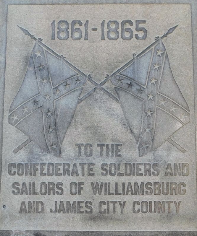
(front)
1861-1865
To the
Confederate Soldiers and
Sailors of Williamsburg
and James City County
(left)
Erected by the United Daughters
of the Confederacy and the
Citizens of Williamsburg and
James City . . . — — Map (db m185422) WM
Dozens of open ditches crisscrossed Jamestown. A ditch and its mound could mark a property boundary, line the edge of a road, or drain swampy soil. Ditches also served as handy trash dumps. Two major ditches, several feet wide and hundreds of feet . . . — — Map (db m17316) HM
Tailor Severinus Durfey operated a shop here in the 1770s. He made clothing and retailed a broad array of material, “West India and dry goods of most sorts.” — — Map (db m226930) HM
Jamestown's fort palisade walls were build using materials and techniques like those used originally. The reconstruction follows the footprint of the original 1607 post holes identified during excavations without impacting the archaeological . . . — — Map (db m240210) HM
The early English settlers came to Virginia looking for gold, silver, and precious gems, but never found them. Some of the artifacts they left behind, however, are highly valuable to the archaeologists who excavated Jamestown centuries later. . . . — — Map (db m17204) HM
The foundations of the multi-dwelling structure that stood here match the dimensions called for in legislation passed by the General Assembly in September 1662. This row rouse was standing by September 1668 when the justices of James City . . . — — Map (db m17320) HM
Milliner Elizabeth Carlos purchased this property in 1772 and ran a shop from her home. A 1777 account book notes that she sold a variety of goods, including gloves, hose, ribbons, thread, and textiles. — — Map (db m228231) HM
In 1777 Virginia Gazette printer William Hunter built this house at the back of the Gazette lot and deeded it to his mother, Elizabeth Reynolds. He also provided her a handsome annual income of £40. — — Map (db m227905) HM
Coach maker Elkanah Deane purchased the property in 1772. He advertised that he could build and repair all types of coaches and carriages, as well as "paint and gild them to the best manner”. — — Map (db m227058) HM
Jamestown had a large number of four-footed and feathered residents. A chronicler wrote of “two hundred … cattle, as many goats, infinite hogs in herds all over the woods.” The government required fences to keep the free-roaming . . . — — Map (db m17200) HM
The first documented Africans in English America arrived at Jamestown in August 1619. A Dutch man-of-war captured them from the Spanish, who had enslaved them, and sold them to the Virginia colonists. The “twenty and odd” Africans, some . . . — — Map (db m97319) HM
The first Germans to land in Jamestown, the first permanent English settlement in Virginia, arrived aboard the vessel Mary and Margaret about 1 October 1608. These Germans were glassmakers and carpenters. In 1620, German mineral specialists . . . — — Map (db m194640) HM
"...the fort reduced to a five-square form..."
—John Smith 1608
In 1608, the triangular fort was expanded toward the east. Archaeologists believe this is what John Smith referred to when he records that the fort was "reduced . . . — — Map (db m240213) HM
Here are the remains of Fort Magruder, an earthen redoubt built in 1861 at the center of the Confederate defensive line. The “Williamsburg Line” stretched between the James and York rivers and consisted of fourteen forts, commonly called . . . — — Map (db m10371) HM
The remains of Jamestown now lie buried beneath the ground. Archeologists have unearthed some of the known town site, but the original foundations of structures would erode quickly if left exposed to wind, weather, and acid rain. The foundations . . . — — Map (db m17220) HM
Tobacco, sassafras – the Jamestown gardener was distracted by quick-money crops for export to Europe. Tobacco was even grown in the streets. In 1624 the General Assembly tried to aid the struggling silk and wine industries by ordering each . . . — — Map (db m17317) HM
After 1619 these 100 acres of land were set aside for the benefit of the Jamestown parish church and minister. Richard Buck was the first clergyman to have use of it. Later on Francis Bolton became minister at "James Citty" and he, too, had "leave . . . — — Map (db m31079) HM
John Harvey served as a member of a royal commission investigating conditions in Virginia in 1624. As a reward, he received land at the east end of New Towne. There he probably built a residence and a wharf. A temperamental sea captain, Harvey . . . — — Map (db m17215) HM
George Yeardley arrived in Jamestown in 1610, was appointed captain of the guard, and eventually lieutenant governor. Later knighted and appointed governor of Virginia in 1618, he issued the Great Charter in 1619, establishing the first . . . — — Map (db m17027) HM
Situated near Jamestown, Governor’s Land originally was a 3,000-acre tract encompassing open fields between the James River and Powhatan Creek. The Virginia Company of London set the parcel aside in 1618 to seat tenants who worked the land, giving . . . — — Map (db m2438) HM
In November 1618, The Virginia Company instructed Governor George Yeardley to set aside 3,000 acres of land “in the best and most convenient place of the territory of Jamestown” to be “the seat and land of the Governor of . . . — — Map (db m99077) HM
The 17th century road to Green Spring, home of Governor Sir William Berkeley, was the eastern part of the Great Road, the earliest-developed English thoroughfare in Virginia. The Great Road ran from Jamestown Island toward the falls of the James . . . — — Map (db m2441) HM
Dr. Peter Hay lived here until his death in 1766, leaving steep debt. To make ends meet, his widow, Grissell took in lodgers until the late 1770s. — — Map (db m227917) HM
Cabinetmaker Anthony Hay purchased this property in 1756. After buying the Raleigh Tavern in 1767, he rented the shop to Benjamin Bucktrout, who made and sold furniture, spinners, and coffins. — — Map (db m227909) HM
On May 4th, 1862 Union Division’s of Generals Hooker, Hancock, and “Baldy” Smith encountered units of the Southern Army east of Williamsburg. When the Confederate Army Commander General Joseph E. Johnston became aware of the engagement, . . . — — Map (db m15716) HM
To the glory of God and in grateful memory of those early settlers, the founders of this Nation who died at Jamestown during the first perilous years of the colony. Their bodies lie along the ridge beyond this cross, in the earliest known burial . . . — — Map (db m11377) HM
All that was left of this home was the foundation of a fireplace and two rows of stains in the soil. The house was built on wood posts sunk directly into the ground. Changes in the color of the soil show where the holes were dug to sink the posts. . . . — — Map (db m17358) HM
In 1934, the National Park Service acquired 1,500 acres of Jamestown Island, including New Towne. Since then, the NPS has used different methods to tell visitors about the town. After archaeologists unearthed numerous structures with brick . . . — — Map (db m17211) HM
The raw materials for the smelting of iron were all found here: lime from oyster shells, bog ore from the swamp, charcoal from burned trees. A circular kiln, 10 feet across and lined with baked clay, sat over a pit with an air vent to the surface. . . . — — Map (db m17218) HM
Jackson the smith was at work in his shop . . . Minutes of the General Court, 1623 Protection was of the utmost importance in the early years of Virginia. Gunsmiths like Jamestown resident, assemblyman, and churchwarden John Jackson, were . . . — — Map (db m17212) HM
You are about to enter the site of 1607 James Fort, the heart of the first, permanent English settlement in North America. The sections of log walls stand above archaeological remains of the original palisades. The walls enclosed about one acre, in . . . — — Map (db m11470) HM
Indians knew this as the Powhatan River, the colonists renamed it in honor of their sovereign, James I. It is one of Virginia's longest and broadest rivers. Rising in the Appalachians it flows eastward, often soil laden, 340 miles to the Chesapeake . . . — — Map (db m31087) HM
This part of old “James Towne” has been owned and preserved since 1893 by the Association for the Preservation of Virginia Antiquities. Founded May 13, 1607, “James Towne” was the first permanent English settlement in . . . — — Map (db m10262) HM
Across the swamp lies Jamestown Island. Powhatan Creek below you, takes its name from the Indian Chief. To the right is Glasshouse Point, place of early glassmaking and later a part of the suburb of "James Cittie". — — Map (db m30733) HM
Nearby to the east is Jamestown, the original site of the first permanent English colony in North America. On 14 May 1607, a group of just over 100 men and boys recruited by the Virginia Company of London came ashore and estblished a settlement at . . . — — Map (db m2443) HM
The woodland and marsh beyond the water is Jamestown Island, a pear-shape area of some 1,500 acres, being about 2½ miles in length. It is separated from the mainland by Back Creek. In more recent times the wide mouth of this creek, which you . . . — — Map (db m31077) HM
The ancient road that linked Jamestown, the original colonial capital, with Middle Plantation (later Williamsburg) followed a meandering course. It departed from Jamestown Island and then turned northeast, crossing Powhatan and Mill Creeks. As it . . . — — Map (db m194909) HM
This plaque marks the rededication of Jamestown Settlement on the eve of the Jamestown Quadricentennial and upon the occasion of its 50th anniversary and completion of its comprehensive facilities master plan, executed between 1997 and 2007. . . . — — Map (db m98077) HM
The First and Second Churches Captain John Smith reported that the first church services were held outdoors “under an awning (which was an old sail)” fastened to three or four trees. Shortly thereafter the colonists built the first . . . — — Map (db m17053) HM
John Smith Explores the Chesapeake
Captain John Smith explored the Chesapeake Bay in the early 1600s seeking precious metals and a passage to the Pacific. He traveled the James, Chickahominy, and York rivers in 1607, and . . . — — Map (db m238167) HM
Kingsmill Plantation, the home of Col. Lewis Burwell, was built in the mid-1730s and consisted of a mansion, outbuildings, garden, and 1,400 acres. The house burned in 1843. Only the office and the kitchen still stand; they are among the earliest . . . — — Map (db m165422) HM
Charles Lewis is believed to have owned this property from 1785 to 1806. Exterior portions of the lower chimney brickwork are believed to remain from the time of his occupancy. — — Map (db m228028) HM
The Loch Ness Monster opened in Busch Gardens Williamsburg in 1978 as the World's tallest coaster, standing at a height of 130ft. With a layout as a twisting as the beast that lends it its name, the Loch Ness Monster features the world's first and . . . — — Map (db m220461) HM
This lot was owned by the Ludwell family from 1715 to 1839. The house on the site was described as a “tenement ,” or rental property in 1770. — — Map (db m227913) HM
Here is a redoubt in the line of Confederate defenses, built across the James-York Peninsula in 1861-62 by General John B. Magruder. — — Map (db m10540) HM
This plantation was allocated to the London-based Society of Martin's Hundred by 1618 and was later assigned 21,500 acres. It was initially settled in 1620 around Wolstenholme Town, its administrative center, located near the James River. . . . — — Map (db m9495) HM
The first Martin's Hundred Parish church was probably built at Wolstenholme Town, an early 17th-century settlement that was located a mile southeast of here. None of the structures excavated there have been identified as a church; it may have been . . . — — Map (db m9497) HM
Spinster Mary Stith resided here until her death in 1816. She left the house, the lot, and most of her estate to three former slaves in gratitude for their past services. — — Map (db m227047) HM
Evidence from wills, deeds, land plats, patents, and court cases helps to identify structures excavated by archaeologists. When historians digitalized two 17th-century land plats and superimposed them on a modern map of Jamestown, they matched a . . . — — Map (db m17310) HM
This area, like a peninsula and bounded on three sides by a marsh, is just across Back River from Jamestown Island. In 1625 there were a number of houses and 25 people living here. The settlement had close community ties to “James Citty” . . . — — Map (db m31073) HM
This circa 1775 house is named for John Orrell, who acquired it in 1810. Earlier documentation is unknown, but the building appears on the “Frenchman’s Map” of Williamsburg in 1782. — — Map (db m228024) HM
Brick, lime, and pottery kilns operated throughout Jamestown. A small paved pit here, filled with oyster shells and moistened lime, marked a kiln where mortar or plaster was made. Different pits produced varying qualities of mortar and plaster. . . . — — Map (db m17314) HM
When the English colonists arrived in 1607, they landed in Paspahegh Country, which extended westward along the shore of the James River to the Chickahominy River and beyond.
The Native Americans who lived here were Algonquin speakers that fished, . . . — — Map (db m90951) HM
During the Peninsula Campaign of 1862, both Confederate Gen. Joseph E. Johnston and Union Maj. Gen. George B. McClellan had their armies west toward Richmond on this road. Johnston evacuated Yorktown on 3-4 May and withdrew up the Peninsula, with . . . — — Map (db m10118) HM
Apothecary Peter Hay dispensed drugs and provided surgical, midwifery, and general medical services here. He also sold spices, cooking oils and teas. — — Map (db m227050) HM
To the north, Jamestown Island is ringed with slow moving water and a marsh of reeds, cypress, and pine. One of the first industries attempted at Jamestown was the extraction of pitch and tar from the pine trees in this swampy area. Pitch, tar, and . . . — — Map (db m17219) HM
Erected in 1922, this statue by William Ordway Partridge, honors Pocahontas, the favorite daughter of Paramount Chief Wahunsenacawh (better known as Powhatan), ruler of the Powhatan Paramount Chiefdom. Pocahontas was born around 1595, probably at . . . — — Map (db m11371) HM
Matoaka, nicknamed Pocahontas (“mischievous one”), the daughter of Powhatan, was born about 1597. She served as an emissary for her father and came to Jamestown often in 1608. In 1613, Samuel Argall kidnapped Pocahontas while she visited the . . . — — Map (db m194910) HM
James Bray owned land nearby in Middle Plantation by the 1650s, and Quarterpath Road probably began as a horse path to one of Bray’s quarters or farm units. Over the years, the road was improved; it extended to Col. Lewis Burwell’s landing on the . . . — — Map (db m130380) HM
Early records tell of a land sale in 1636 being these 500 acres with “all howses...gardens, orchards, tenements.” The property passed from Thomas Crompe “of the Neck of Land” to Gershon Buck son of the Reverend Richard Buck . . . — — Map (db m31075) HM
Richard Crump owned this property from 1785-1794. The Rev. John Bracken purchased it from Crump and added it to the block of eight lots that he owned to the west. — — Map (db m227984) HM
To the glory of God and in memory of the Reverend Robert Hunt, Presbyter. appointed by the Church of England, minister of the colony which established the English Church and English civilization at Jamestown, Virginia in 1607, his people, members of . . . — — Map (db m17023) HM
Several Jamestown families lived in row houses. This row of three houses was occupied at least from 1560 through 1720. Elaborate ironwork found here suggested that the row was handsomely furnished. Perhaps the row was home to the government . . . — — Map (db m17114) HM
Near this location in 1901, Samuel H. Yonge, a civil engineer with the U.S. Army Corps of Engineers, spearheaded the design and construction of a seawall/revetment that halted the rapid erosion and loss into the James River of the most-historic part . . . — — Map (db m194712) HM
The Virginia General Assembly is the oldest representative legislature in the Western Hemisphere. Meeting for the first time in July 1619, it gathered in the “most convenient place we could finde to sitt in … the Quire of the churche.” . . . — — Map (db m128481) HM
. . . in ye sd Col Swanns Ordinary at James City. Minutes of the General Court, 1677 Although councilman Colonel Thomas Swann resided across the James River at his Swann Point plantation, he also leased a Jamestown tavern that provided . . . — — Map (db m17213) HM
Charles Taliaferro erected the right side of this building as a retail store in the 1770s. Businessman Jesse Cole expanded it into its present residential form in 1804. — — Map (db m227149) HM
Coachmaker Charles Taliaferro made riding chairs and harnesses in the 1770s. In 1804, Jesse Cole purchased the shop and used it as a post office and general store. — — Map (db m227150) HM
John Tayloe II, a wealthy and influential planter from the Northern Neck of Virginia purchased this house in 1759. He used it as his in-town residence while serving on the Governor’s Council. — — Map (db m227912) HM
In front of you is the “Archaearium,” an archaeological museum of early Jamestown history. Its exhibits explore both the James Fort excavations and those of the site above which it sits – the Statehouse, the first building built . . . — — Map (db m17044) HM
Originally constructed in 1890
at the east end of Duke of Gloucester Street
by Judge Cary Peyton Armistead
Moved here by Colonial Williamsburg in 1995
Includes bricks, timbers, sash windows and doors
from R. Charlton’s Colonial Era . . . — — Map (db m226925) HM
This interpretation of a "mud-and-stud" structure was made possible by a generous donation from The Jamestowne Society.
The gift was made in honor of archaeologist Dr. William M. Kelso, whose 25 years of leadership and perseverance led . . . — — Map (db m240209) HM
Builder Benjamin Powell owned this property from 1763 to 1782. He built or repaired several prominent buildings, including the public gaol. The tower at Bruton Church, and the public hospital. — — Map (db m228198) HM
Presented by The English Inns of Court to commemorate the 400th Anniversary of the founding of the Colony at Jamestown in 1607 April 2007 — — Map (db m17049) HM
In honour of The First General Assembly of Virginia, here on the thirtieth day of July A.D. 1916. Summoned by Sir George Yeardley, Governor General of Virginia, under authority from the London Company, pursuant to the charter granted by King . . . — — Map (db m15727) HM
A few days after he arrived at Jamestown in May 1607, George Percy wrote that he and his party “espied a pathway” and were “desirous to knowe whither it would bring us.” Most likely they discovered a trail used by Paspahegh . . . — — Map (db m17117) HM
Jamestown provided the colonists with a deep-water port in a defensible location. Because shoreline settlements and camps allowed for easier transportation and a ready source of food, the colonists and Virginia Indians both lived on or near major . . . — — Map (db m17198) HM
Due to the loss of James City County records during the Civil War, little is known about this early 19th-century cottage. Actor Cary Grant resided here while starring in the Hollywood film The Howards of Virginia in 1940. — — Map (db m228019) HM
The site of the first landing is directly ahead of you in the river. During the years since 1607, the river has eroded about 25 acres of this part of Jamestown Island. The original shoreline was close to the present edge of the river channel, . . . — — Map (db m11374) HM
Just below the ground’s surface lie the original foundations of the first purpose-built statehouse at Jamestown. From the very beginning, the efforts at Jamestown were influenced by the laws and legal institutions of England. American . . . — — Map (db m17046) HM
These foundations were discovered & identified in 1903 by Samuel H. Yonge, Designer of the sea-wall & author of “The Site of “Olde Jamestowne,” 1607-1698.” ----- • ----- Placed by the Association for the Preservation of . . . — — Map (db m17041) HM
When the English arrived in 1607, Paramount Chief Powhatan controlled much of Tidewater Virginia. His sphere of influence included over 30 tribes and 160 towns located from the coast to the James River fall line. The colonists built Jamestown in the . . . — — Map (db m31057) HM
Despite the success of tobacco, the crown instructed Virginia’s governors to diversify and encourage trades in the colony. Governor Sir John Harvey supported this endeavor. During the 1630s, he employed a variety of tradesmen on this property . . . — — Map (db m17359) HM
At Trebell's Landing on the James River a mile southwest of here, the artillery and stores of the American and French Armies were located in September 1781. They were then conveyed overland some six miles to the siege lines at Yorktown. The troops . . . — — Map (db m9501) HM
Original freight wagon built circa 1810 for the Minnick family of New Market, Virginia. Used to haul freight between New Market and Baltimore until 1856. Placed in storage from 1882 until 1939. Used in the Virginia exhibition at the 1939 New York . . . — — Map (db m226928) HM
“ … not at all replenished with springs of fresh water … their wells brackish, ill-scented … and not grateful to the stomach.” If a well at Jamestown was sunk to the right depth, it could yield “sweet water.” Too deep a well . . . — — Map (db m17202) HM
A 1735 deed describes this building as “ one house then letten for lodgins to William Randolph, Esq., situate at the back of the garden…” Randolph a wealthy planter and politician was the uncle of Patriot Peyton Randolph — — Map (db m227897) HM
Wowinchapuncke was the chief of the Paspahegh
Indians when the English established Jamestown
in the tribe’s territory in 1607. He consistently
resisted the English intrusion, earning both
respect and hostility from Jamestown leaders.
Captured . . . — — Map (db m26343) HM
Physician Phillip Barraud owned this property from 1782 to 1801. He worked with Apothecary James Galt as visiting physicians at the public hospital until 1799. The Barraud House retains much of its original woodwork and is one of the best preserved . . . — — Map (db m228032) HM
Baker Peter Moyer owned this house until 1792. Scottish merchant Ebenezer Ewing and his heirs owned it from about 1795 until 1840. — — Map (db m228124) HM
Used by several merchants as a store in the 1770s and 1780s, this building and the adjacent tavern were acquired by Phillip Moody in 1796. His documents term this building a barber shop. — — Map (db m227035) HM
Blacksmith Josias Moody and his heirs owned this house from 1794 until 1845. Little is known about Moody, but noted Lawyer St. George Tucker paid him £10 for blacksmithing work in 1794. — — Map (db m228117) HM
Successful saddler Alexander Craig acquired this house in 1755. He lived in the left portion and operated his business on the right until his death in 1776. — — Map (db m227152) HM
Emigrant printer Purdie bought this house in 1767. He launched the Virginia Gazette in 1774. One of three local newspapers of the same name. — — Map (db m227155) HM
307 entries matched your criteria. Entries 101 through 200 are listed above. ⊲ Previous 100 — Next 100 ⊳