The town of Warren was first settled by people from the Pokanoket Tribe, later known as the Wampanoag. The Pokanoket controlled the land from Plymouth to the eastern shores of Narragansett Bay. In 1620, “Osamequin”, which translates as “Yellow . . . — — Map (db m223848) HM
In memory of the honored founders of Mendon 'the old mother town.' Settled 1663. Incorporated 1667. Eight towns are now located on her original territory. Near this spot Mendon's first three meeting houses were built."
Founders 1668: . . . — — Map (db m91558) HM
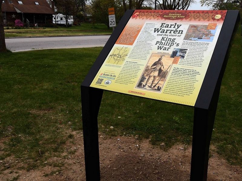
The Sowams Heritage Area includes Barrington, Bristol, East Providence, Providence, and Warren RI, and Rehoboth, Seekonk and Swansea, MA. Sowams means "Southern Area” and was the historic home of the Pokanokets (later described as Wampanoags) . . . — — Map (db m155910) HM
Site of capture of the Wamponoag Indian Chief Anawan by Captain Benjamin Church on August 28th 1676, thus ending King Philip's war — — Map (db m44921) HM
In the 'Miery Swamp,' 100 feet W.S.W. from this spring, according to tradition, King Philip fell, August 12, 1676, O.S. This stone placed by the R.I. Historical Society. December, 1877. — — Map (db m86296) HM
The area of today’s City of East Providence was inhabited by the Pokanoket Tribe, later known as the Wampanoag, for over 10,000 years. In 1621, the Massasoit Ousamequin entered into a mutual protection agreement with the English settlers in . . . — — Map (db m207459) HM
The first settlement of Waterbury was made on land in this region about 1675. The settlement was abandoned during King Philip’s War and was resumed around the present Waterbury green after 1677. — — Map (db m23600) HM
Site of first house in Acton, built by Captain Thomas Wheeler in 1668. He was commissioned to keep fifty cattle for the inhabitants and at night protect them in a yard from wild beasts. He was wounded by the Indians in King Philip's War. — — Map (db m48823) HM
Near by stood a garrison house, residence of Captain James Parker, Commander of the town forces in King Philip's War. Here Captain Parker parleyed with the Indian Chief John Monoco regarding his threat to burn Groton and Boston, March 13, 1676. — — Map (db m48821) HM
Fifty rods east is the site of the Old Fort built about 1670 as a place of defense and refuge in time of need. During King Philip’s War an Indian making insulting gestures on Indian Rock across the Nemasket River was shot from the fort. — — Map (db m154467) HM
The Stockbridge mansion, built before 1660, stood on this site. It was a garrison house in King Philip’s War for protection of the mills, and was successfully defended. The pond and mill were made famous by Woodworth’s poem "The Old Oaken Bucket." — — Map (db m48800) HM
A portion of the house built by John Williams in 1634 is incorporated in the present house. It was a "garrison" or place of refuge and defense during King Philip's War. — — Map (db m48804) HM
One mile to the southwest, off the North Brookfield Road, Edward Hutchinson’s company seeking a parley with the Nipmucs was ambushed by Indians August 2, 1675, and more than half were slain. Captain Hutchinson died from his wounds. Captain Thomas . . . — — Map (db m48786) HM
Upon this rock May 2nd 1676 was made the agreement for the ransom of Mrs. Mary Rowlandson of Lancaster between the Indians and John Hoar of Concord. King Philip was with the Indians but refused his consent. — — Map (db m32257) HM
The first settlement of this lonely region called Quinsigamond was attempted in 1673, but abandoned during King Philip's War. A second settlement, attempted in 1684, soon named Worcester, was also temporarily abandoned because of Indian hostility. . . . — — Map (db m48046) HM
The first settlement of this lonely region called Quinsigamond was attempted in 1673, but abandoned during King Philip's War. A second settlement, attempted in 1684, soon named Worcester, was also temporarily abandoned because of Indian hostility. . . . — — Map (db m48047) HM
The first settlement of this lonely region called Quinsigamond was attempted in 1673, but abandoned during King Philip's War. A second settlement, attempted in 1684, soon named Worcester, was also temporarily abandoned because of Indian hostility. . . . — — Map (db m48048) HM
Upon the rock fifty feet west of this spot Mary Rowlandson, wife of the first minister of Lancaster, was redeemed from captivity under King Philip. The narrative of her experience is one of the classics of colonial literature. — — Map (db m48794) HM
Defense was a prime necessity to the early settlers of Salem Village, and as early as 1671 the male inhabitants began meeting here for military drill. This preparation was heightened in 1675 during the King Philip War in which many villagers took . . . — — Map (db m17991) HM
After the Pilgrims’ arrival, Native Americans in New England grew increasingly frustrated with the English settlers’ abuse and treachery. Metacomet (King Philip), a son of the Wampanoag sachem known as the Massasoit (Ousamequin), called . . . — — Map (db m107448) HM
In memory of Hugh Cole. Born London, England, 1627. Died Swansea, Mass, 1699. An honorable and useful citizen of Plymouth Colony. Many years a representative of Swansea, Mass. A sergeant in King Philip's War, 1675. An esteemed friend of King . . . — — Map (db m223850) HM
This Tablet erected by the Rhode Island Society of Colonial Wars in recognition of the exceptional services rendered by Col. Benjamin Church
His fearless leadership and effective command during King Philip's war 1675-1676 — — Map (db m52392) HM
This intersection was the earliest center of colonial Providence. A grist mill stood just north, at the falls of Moshassuck River, and a tannery and taverns were nearby across the street. In 1676 the natives of many tribes united against the New . . . — — Map (db m56152) HM
Rowlandson rock is the site where captives such as Mary Rowlandson, her son, and others from Lancaster, spent their first night. The Indians holding them captive had just raided and burnt the Rowlandson Garrison and all of the buildings in town.
. . . — — Map (db m33566) HM
In the field nearby was situated the garrison house of the Rev. Joseph Rowlandson first ordained minister of Lancaster. During his absence on February 10, 1675-76 this garrison house was attacked and destroyed by the Indians. The inhabitants were . . . — — Map (db m32253) HM
In Memory of the Regicide
Col William Goffe
A member of the High Court of Justice which in 1649 tried and condemned King Charles 1st of England and a signer of the kings death warrant. He served with distinction in the Parliamentary Army and in . . . — — Map (db m34817) HM
Oldest Defenses in the Mass. Bay Colony. Thrown up in 1625 by Capt. John Hewest. Occupied in King Philips War 1675 and in King Georges War 1743. Companies under Capt. John McCaw and Capt. John Lane stationed here during War for Independence . . . — — Map (db m36355) HM
On this site stood the stone residence of Peter Disbrow, designated by the Rye colonists as the "Rye Fort" when it was offered for protection from the Indian attack during "King Philip's War" of 1675.
Around 1728 the present frame (North) . . . — — Map (db m34485) HM
Due to land disputes and broken peace treaties between local natives and early English settlers, King Philip's War took place for 14 months during 1675 and 1676. Captain Michael Pierce's fight with the natives occured on this spot in March of 1676. . . . — — Map (db m45093) HM
The Native American Sachem, Metacomet of Pokonoket, called King Philip by the English, Sachem or chief of the Wampanoag people is reported to have used this area as a stopping place. It provided a natural fortress for his many visits to the . . . — — Map (db m56217) HM
Erected August
1838
—
On this Ground Capt. Thomas Lathrop and eighty four men under his command, including eighteen
teamsters from Deer field, conveying stores from that town to Hadley, were ambuscaded by about
700 . . . — — Map (db m37542) HM
On the crest of George Hill, near by, is situated Rowlandson Rock where the captives from the Rowlandson garrison house passed their first night after the burning of Lancaster by the Indians February 10, 1675–76. — — Map (db m48799) HM
One of the thirteen original colonies
Capital-Boston
A group of zealous Puritans known as the Separatists or “Pilgrims” left England and established a colony at Plymouth in New England in 1620. In 1626, a Puritan settlement was . . . — — Map (db m97856) HM
The present settlement of Waterbury
was made on land in this region.
The original settlement known
as Town Plot was abandoned
during King Philip’s War and the
town site was moved to this location
in 1677.
The Mattatuck Historical . . . — — Map (db m116385) HM
Canterbury
Originally part of Plainfield the town was incorporated in October, 1703. The town area includes the original Quinebaug Plantation of Major James Fitch, son of the Reverend James Fitch of Saybrook Fort, a first settler of Norwich in . . . — — Map (db m140490) HM
Winneccunnett Pond is the only sizable, natural body of water in Norton, Massachusetts. Winneccunnett is a Native American word meaning "the place of the black geese." A Native American village was established on the north end of the pond long . . . — — Map (db m56459) HM
Osamequin Nature Preserve and Bird Sanctuary is named in honor of the Massasoit (Great Leader) Osamequin (or Ousamequin) of the Pokanoket Tribe. Osamequin, which means Yellow Feather, led his people in helping the settlers of the Plymouth Colony . . . — — Map (db m223753) HM
Bissell Ferry
1641 - 1917
This quiet spot with its big old house was once the scene of great activity. In 1614 Adrian Block, a Dutch explorer, found Indians living between the Scantic and the Podunk rivers.
At the request of Sachem . . . — — Map (db m114057) HM
In Memory Of
Hon. Abraham Doolittle
Died Aug. 11, 1690 Ae. 70.
Born in England, was progenitor of the family in America, father of thirteen children, survived by seven sons and three daughters.
Widow, Abigail Moss died Nov. 5, 1710 Ae. . . . — — Map (db m27571) HM
This area was long the home of the Mohegan Indians, by settlement before the Colonial period, and by reservation until more recent years. Prominent Indian sachems were Owaneco and his father Uncas, who defeated the chief Miantonomoh, a . . . — — Map (db m114904) HM
After glaciers retreated from our region 6,000 years ago, Native Americans settling along the coast flourished on its rich resources. When Europeans arrived about 400 years ago and began establishing settlements, they also favored coastal . . . — — Map (db m186467) HM
In January 1680, following King Philip’s War, Plymouth Colony sold the area “known by the name of Mount Hope Neck and Poppasquash Neck”, which was part of Sowams, the ancestral home of the Pokanoket Tribe. Following the sale, four wealthy Boston . . . — — Map (db m186127) HM
In 1675, after King Philip's War, the lands known as Mount Hope were ceded to Plymouth Colony. Plymouth sold the area that became the Town of Bristol and its deep water harbor to four proprietors, who laid out streets relative to the waterfront. . . . — — Map (db m222772) HM
Enfield
Settled 1680
Established as the township of Enfield, 1683, this area was part of the Springfield Plantation granted to William Pynchon and others by the Massachusetts General Court. Springfield was settled in 1636, but no effectual grants . . . — — Map (db m113909) HM
The largest 17th century settlement in Cape Elizabeth - which included South Portland and Cape Elizabeth prior to 1895 - was established in 1658 near Spring Point. However, the onset of the French and Indian Wars in 1675 necessitated frequent . . . — — Map (db m55673) HM
King’s Rock, spanning 200 ft. along today’s Warren/Swansea border, was a significant location along the route and an important place for tribal gatherings under Metacom’s older brother, Wamsutta. Tribes from all over New England were known to have . . . — — Map (db m235790) HM
Near this spot stood the John Myles Garrison House. The place of meeting of the troops of Massachusetts Bay and Plymouth colonies.
Commanded by
Majors Thomas Savage and James Cudworth, who marched to the relief of Swansea at the opening of . . . — — Map (db m56215) HM
In 1639, Helen and Nicholas Easton, John Clarke, William Coddington and others left Portsmouth, the settlement founded in 1638 by Anne Hutchinson and others on the northern end of Aquidneck Island. They came south and founded Newport. Newport’s . . . — — Map (db m48498) HM
Mother Mendon
Mendon began as an eight-mile square tract purchased for twenty-four pounds from several Native American tribes in 1662. In 1663, fifteen families, mostly from Braintree and Weymouth, undertook the arduous task of creating this new . . . — — Map (db m195663) HM
Attacked
within their fort upon this island
the Narragansett Indians
made their last stand
in King Philip's War and
were crushed by the united forces
of the Massachusetts Connecticut
and Plymouth Colonies
in the
“Great Swamp Fight” . . . — — Map (db m22879) HM
Welcome to Augusta
Indigenous people occupied the Augusta area for thousands of years before European explorers arrived. Little evidence remains of their time here, but patches of forested land along the Kennebec give us a glimpse . . . — — Map (db m186068) HM
Boston Harbor Islands offer opportunities for visitors to tour historical sites, observe wildlife, participate in recreational activities ranging from hiking and bird watching to swimming and fishing, or just enjoying a picnic and a day of quiet . . . — — Map (db m215530) HM
By liberty of conscience we understand not only a mere liberty of the mind, but the exercise of a visible way of worship this day my country was confirmed to me by the name of Pennsylvania. My God will, I believe, bless and make it the seed of . . . — — Map (db m135453) HM
Civil War
Veterans
of
Northfield, Ma
1861 - 1865
Andrew J Ames ★ •
Silas W Bailey •
Richard D Battles ★ •
Jonathan H Blake •
Loren C Boyden •
Charles C Brewer •
Elhanan J Britt •
McKenzie B Britt ★ . . . — — Map (db m231044) WM
* Inflectional forms of words are their plurals, singulars, and possessives as well as gramatical tenses and similar variations.