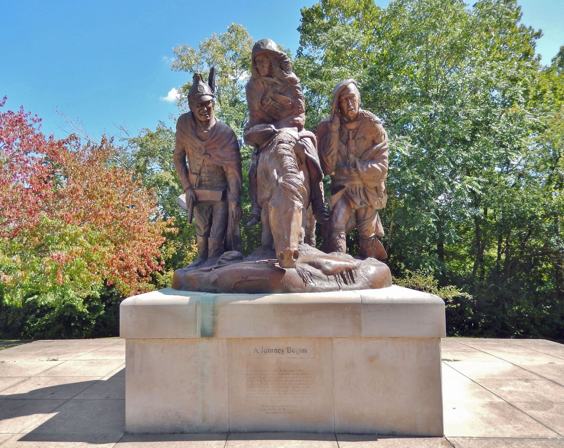
A tribute to those who, in December 1812, displayed the courage to protect their culture and the compassion to embrace another as they departed the battlefield of the Mississinewa. Following the battle, the American commander ordered that captured . . . — — Map (db m233756) HM
Garfield salutes all things British in Grant County, from the historic 1812 Battle of the Mississinewa to a traditional English meal of Fish 'n Chips at Payne's Restaurant.
To hear more about this Garfield and others on the trail . . . — — Map (db m220139)
Marker Front
In Honor of
The men from
Harrison County
killed or died of wounds at the
Battle of Tippecanoe
Nov. 7, 1811
and
War of 1812
Marker's Left Side
Capt. Spier Spencer’s Co.
Mounted Rifleman . . . — — Map (db m9751) HM
Built 1817 - - Home of Col. Thomas Posey, son of Gov. Posey. Col. Posey (1792 - 1863) served as Treasurer of Harrison County; Cashier of Corydon Branch of the Bank of Vincennes; U.S. Military Pension Agent in Indiana; Adjutant General of Indiana; . . . — — Map (db m241643) HM
Both civil and military, who gave us our country, our flag and our Constitution; to those of 1812, the Mexican, the Civil, the Spanish American and World War; and to all loyal citizens, who have aided the United States by defending and promoting the . . . — — Map (db m200549) WM
Site in town of stockade built in 1812 on old Indian trail for protection of the settlers in this area. Garrisoned by Maj. John Tipton and his militia Rangers in 1813. Marker on the site. — — Map (db m167022) HM
A Pennsylvanian who came to Indiana and established himself on the river site where in 1810 he laid out a town for the county seat of Jefferson County and named it Madison in honor of the then president. He was the first territorial representative . . . — — Map (db m195500) HM
Welcome to
"Grouseland"
Built 1803 - 1804
Home of
William Henry Harrison
Governor Indiana Territory 1800 - 1812
President of the United States 1840
Mansion owned and restored by
Francis Vigo Chapter
Daughters of the . . . — — Map (db m167023) HM
The great Shawnee leader lives on as a symbol of Native pride and pan-Indian identity. In the years 1810 and 1811 Tecumseh defended the rights of his people in meetings in Vincennes with William Henry Harrison, Governor of the Indiana Territory. . . . — — Map (db m61831) HM
Men of Courage, Patriotism and Enterprise who are desirous of serving their country in the honorable capacity of Soldiers in this important crisis of our national affairs, are informed that the subscriber has established a . . . — — Map (db m226432) HM
Captain Zachary Taylor has been placed in command of the garrison near this. To all the qualities which are esteemed for an amicable man, he appears to unite those which form a good officer. In the short time he has been a commander, . . . — — Map (db m226422) HM
To Indiana's Silent Victors
War with Mexico 1846 1847 1848 Indiana Regiments No's. 1, 2, 3, 4, 5 4585 men
Indian and British War 1811-1812 Battle of Tippecanoe Indians defeated Nov. 7, 1811
War of the Revolution Capture of . . . — — Map (db m105767) WM
The Shawnee orator, diplomat and warrior was born near present-day Dayton, Ohio, in 1768. Tecumseh strove to bond the scattered Native American peoples into a united opposition to white encroachment upon their ancestral lands. In 1791 he joined . . . — — Map (db m132830) HM
North 87 degrees East 437 feet. War Chief Francis Godfroy's Council Chambers. Here May, 1812, twelve tribes of N.W. Territory voted not to join English. Tecumseh objected and joined Canada. Across road Godfroy's trading post and Mt. Pleasant home, . . . — — Map (db m61139) HM
This Memorial erected in Memory of the following soldiers who are buried in this Cemetery.
The exact location of some are unknown. ———————————
Revolutionary War
Thomas Mason • . . . — — Map (db m13280) WM
Built in the year 1835 by Major Isaac Compton Elston. A soldier in the War of 1812 and Black Hawk War. He was then in his thirty-ninth year, a pioneer merchant, banker and financier.
Presented to Wabash College by Major Elston's grandson, Isaac . . . — — Map (db m6427) HM
Estab. Dec. 1829, the Cemetery predates Waynetown (then Middletown) which was estab. July 1830. The last burial was in 1908. William Bratton, the only member of the Lewis and Clark Expedition (1804 - 1806) to be buried in Indiana, is buried here. . . . — — Map (db m81731) HM
A war between Britain and the US. The
immediate causes of the War of 1812 were
a series of economic sanctions against
the US and American outrage at the
British practice of impressment.
US Battle deaths 2,260 — — Map (db m222448) HM
So named because armies of Gen. Wm. H. Harrison (1811) and Gen. Saml. Hopkins (1812) bivouacked nearby.
A busy village during waterpower days, court was held here before the county was judicially organized. — — Map (db m17285) HM
Indian boundary line established by treaty with Miami Indians at St. Marys, Ohio October 6, 1818. Erected by Mississinewa Chapter, D.A.R. — — Map (db m97227) HM
A fort built in May 1813, by the George Buchanan family, as a defense against the Indians. The miniature replica of the blockhouse, was erected on the same site and was dedicated on August 26, 1927. — — Map (db m200327) HM
When Ripley County was formed in 1818, its name was inspired by the popular War of 1812 hero Eleazer Wheelock Ripley.
He was born April 15, 1782, in Hanover, New Hampshire. Ripley graduated from Dartmouth College (founded by his namesake . . . — — Map (db m100055) HM
A native of Kentucky, was a charter member of the Versailles Masonic Lodge and served as Grand Master of Masons in Indiana in 1846, the only Ripley County Mason to do so. Served in both houses of the Indiana General Assembly and Constitutional . . . — — Map (db m100054) HM
(Side 1)
Kimberlin, a Revolutionary War veteran, was first person to purchase land in what is now Scott County In 1804, he bought Tract 264 of land grant to soldiers of George Rogers Clark. His family settled 1805 in well-built cabin . . . — — Map (db m99663) HM
Pigeon Roost, settled 1809 in Clark County, was attacked on September 3, 1812. Over twenty settlers and an unknown number of Indians were killed. Clark County militia unsuccessfully pursued the remaining Indians. That same month Fort Harrison . . . — — Map (db m99656) HM
A community established here in 1809 was attacked by Indians on September 3, 1812; 15 children and 9 adults were massacred; only one family escaped to spread the alarm. — — Map (db m99659) HM
In memory of the pioneer heroes, Twenty-Two in number, massacred at Pigeon Roost defeat by the Shawnee Indians, Sept. 3, 1812
The Sixty-Third General Assembly of Indiana appropriated Two-Thousand dollars for the erection of this monument. . . . — — Map (db m245539) HM WM
This burial site is for the victims of the Pigeon Roost Massacre in 1812 and was originally marked by only a few stones and a large Sassafras tree. This stump monument denotes the area of the original tree — — Map (db m245523) HM
To commemorate our bicentennial year, this plaque is dedicated in honor of Captain Spier Spencer for whom Spencer County was named. He was a hero who lost his life at the Battle of Tippecanoe in 1811. — — Map (db m243594) HM
A War of 1812 military action occurred in September 1812 three miles west/southwest of here. While escorting supplies from Fort Knox near Vincennes to Fort Harrison at Terre Haute, Sergeant Nathan Fairbanks and approximately a dozen soldiers were . . . — — Map (db m21761) HM
General Wm. H. Harrison's army made its last camp in Sullivan County here at Big Springs on Sept. 29, 1811. Harrison used Benjamin Turman's fort as his headquarters. With spring water available, it was an ideal location for 1000 men including 160 . . . — — Map (db m229777) HM
In tribute to Major Joseph Hamilton Daviess, Grand Master of Masons in Kentucky, who fell in battle here, and to the many Freemasons of General Harrison's command whose valor is held in grateful remembrance. — — Map (db m36281) HM
Urged by the Prophet, Tecumseh's brother, Indians attacked army of Gen. W.H. Harrison Nov. 7, 1811. The victory by Harrison broke Indian power. — — Map (db m69372) HM
William Henry Harrison, first governor of Indiana territory, 1800-1812. General, American forces, battle of Tippecanoe, November 7 1811. 9th President of the United States. — — Map (db m200296)
Dedicated to the memory of the courageous pioneers who so successfully defended Fort Harrison in the activities which served as a Prologue to The War of 1812 — — Map (db m58414) HM
Built by Gov. Harrison, Oct., 1811, enroute to Tippecanoe to disperse the Indians at Prophet's Town.
Capt. Zachary Taylor defended the Fort against a savage Indian attack, Sept., 1812.
De-activated in 1822. — — Map (db m19796) HM
About 1747 the British encouraged the Miami at Kekionga to leave the French influence for their protection and cheaper trade goods at Pickawillany. The British post near Piqua, Ohio. Osandish, grandfather of Metocinyah, died shortly after he led his . . . — — Map (db m72540) HM
Chief Metocinyah, whose village was destroyed by Campbell's troops during the Mississinewa Expedition of 1812, has been credited with quieting the Miami after the invasion. This service to the Americans is believed to be the reason his band was . . . — — Map (db m215012) HM
Born in New Hampshire and a veteran of the War of 1812, Governor Cass was a skilled maker of treaties.
In 1831 President Andrew Jackson appointed Governor Cass Secretary of War. He later served as Minister to France.
In the mid 1840's, . . . — — Map (db m76578) HM
A veteran of the Battle of Tippecanoe, General Tipton was apointed to the Indian Agency located in Ft. Wayne Indiana, by President Monroe.
John Quincy Adams appointed Major General Tipton Indian Commissionder to oversee treaties with the Indians . . . — — Map (db m76577) HM
Located 40 rods west of this spot. Est. before 1812. Salem's early settlers are buried here including Brocks, Kemps, Hendersons; also John Zink, a ranger with Col. Dawalt, fatally wounded by Indians after the Pigeon Roost Massacre. — — Map (db m74079) HM
The bronze statue of Col. Isaac White is erected and dedicated in the memory of a father, husband and patriot soldier who died at The Battle of Tippecanoe on November 7, 1811. Col. White is the namesake of White County, Indiana. On April 1, 1834 . . . — — Map (db m199739) HM WM
After General William Henry Harrison relieved Fort Wayne, he ordered Colonel James Simrall in September 1812 to prevent further Miami Indian attacks in the area. The Miamis fled as troops destroyed villages, crops, and supplies along Eel River; . . . — — Map (db m1335) HM
Ten Rods North. Site of a Miami trading post 1762. Fortified by Chief Little Turtle 1779. House built for him after Greenville Treaty. Spared when Fort Razed by Colonel Simrall. Sept 1812.
Funded by Col. Augustin de le Balme Chapter, Daughters . . . — — Map (db m222041) HM
1752.......................1812
Site of British Fort
and
Last Home of
Chief Little Turtle
(Me-she-me-noc-quah)
1795.......................1812 — — Map (db m52803) HM
Little Turtle (Mishikinoqkwa), c. 1747–1812, was born and raised here on the Eel (Kenapocomoco) River. The Miami village was destroyed by American troops in 1812 and most of the tribe was removed from Indiana by 1843. — — Map (db m1336) HM
This County was named for Colonel William Whitley, who was born in Virginia, August 17, 1749, and moved to Kentucky in 1775. He built Whitley House, the first brick house West of the Alleghenies, near Sanford, Kentucky.
This adventurous . . . — — Map (db m12239) HM
Miami captive at 14; adopted by Little Turtle; appointed chief scout by Wayne in 1793; granted farm near Ft. Wayne by Congress for "valiant and conspicuous service." Died in Ft. Dearborn Massacre. — — Map (db m58108) HM
Near this location a government trading post, or factory, was established in 1808 for the use of Sac, Fox, Ioway and Des Moines River Sioux. Initially a temporary facility, christened Fort Madison, in the spring of 1809 and garrisoned by a . . . — — Map (db m229237) HM WM
Marker Front: In 1829, William C. Redfield declared that Davenport lay opposite the future terminus of a “geographical trunk-line route” between the Atlantic and the Mississippi. Nine years later, in 1838, the Iowa Sun and Davenport and . . . — — Map (db m224581) HM
Here was located one of the earliest posts for trading with the Indians established west of the Mississippi River. The Battle of Credit Island was fought August 21, 1814 between the troops of the United States and Great Britain. — — Map (db m228856) HM
Dedicated on August 30 2014 by the city of Davenport and its citizens to commemorate the battle that took place on and around Credit Island on September 4 and 5, 1814.
This was the last battle for control of the upper Mississippi River during . . . — — Map (db m211242) HM WM
Colonel 3d U.S. Infantry
Brevet Brig.-Gen. U.S. Army
Established
Fort Leavenworth May 8, 1827.
Born Dec. 10, 1783
Died July 21, 1834. — — Map (db m42070) HM WM
Like the new nation, the first Stars and Stripes would see fuller development with the passage of time. Under the much-debated Articles of Confederation of 1781, it was agreed that America would create self-governing States in the western domain . . . — — Map (db m56959) HM
For Gen. John Adair, Governor of Kentucky 1820-24. Born, 1757, in South Carolina, came to Ky., 1788. Member of Kentucky Constitutional Convention, 1792. Served in Ky. House of Representatives, 1793-95, 1798, 1800-03, 1817. US Senator, 1805-06, . . . — — Map (db m139816) HM
For Lieut. Col. John Allen, born in Va., 1771, came to Ky., 1779. Practiced law in Shelby County. State Representative, 1801-07, and State Senate, 1807-13. Killed in battle at River Raisin, Jan. 22, 1813, and one of nine officers at that battle for . . . — — Map (db m131262) WM
Formed from Montgomery County, 1811. Named for its many mineral springs. The birthplace of CSA Gen. John B. Hood and US Senator Richard H. Menefee. Owingsville named for Col. Thomas D. Owings. Organizer US 28th Inf. Reg., 1812. Associate in . . . — — Map (db m26286) HM
Bourbon Iron Works Jacob Myers from Richmond, Va. took up land grants here on Slate Creek, 1782. He built the first iron blast furnace in Ky., 1791. John Cockey Owings and Co. formed to operate furnace. Utensils and tools supplied settlers. . . . — — Map (db m110121) HM
Grave of Colonel Arthur Campbell (1743-1811). Statesman, revolutionary soldier, justice, legislator, county lieutenant. Sons, James and John killed in War of 1812. — — Map (db m57938) HM
Home site of John Pollard Gaines.
1795-1857. Fought in War of 1812.
In state legislature, 1825-36.
Major in the 1st Kentucky Cavalry and
an aide-de-camp to Gen. Winfield
Scott, in Mexican war. Elected to
Congress, 1847-49, while prisoner
of . . . — — Map (db m133213) HM
Homesite and grave 1 mile west. B., Orange Co., Va., 1740. D., 1825. 40 years service to his country. Lt. at Fort Pitt, Dunmore's War, 1774. Captain, Botetourt County militia, 1776. Northwest Campaign of George Rogers Clark, 1778. Came to Ky., 1781. . . . — — Map (db m120112) HM
Underground Railroad station. Mansion built by General Taylor, pioneer, banker, statesman. General in the War of 1812. Original house designed by H.B. Latrobe. Present house build, 1837. — — Map (db m135084) HM
Kentuckians crossed here Aug. 1812 marching to relieve Gen. Hull at Detroit. Took Frenchtown (Monroe) Jan. 18, 1813. Four days later all but 30 were killed or captured. Other Kentuckians gathered here Aug. 31, 1813. Led by Gov. Shelby these men . . . — — Map (db m175074) HM
An early army post, built in 1804,
at junction of Licking and
Ohio
Rivers. In War of 1812 used as a
military prison. Kentucky troops
assembled here for the Canadian
invasion, 1813. Used for training
volunteers during Mexican-American
War. . . . — — Map (db m228719) HM
Marker Front:
Col. Percival Butler was appointed Ky.'s first adjutant gen. in Gov. Isaac Shelby's first term. Born in Penn., he was with Washington at Valley Forge and Lafayette at Yorktown. Immigrated to Jessamine Co., Ky., then moved to . . . — — Map (db m22097) HM
Born in Kentucky
April 19, 1791 - August 6, 1880
Transylvania University 1812
War of 1812 - Aide De Camp to Andrew Jackson
River Raisin - Pensacola - New Orleans
Mexican War - Major General of the Volunteers
Commanded 1st Volunteer . . . — — Map (db m22100) HM
Gen. William O. Butler, born Kentucky 1791, died here, 1880. War of 1812: River Raisin, Pensacola, and New Orleans. Gen. Andrew Jackson's staff 1816-17. Cited for heroism in Mexican War 1846-48. Practiced law here. Congressman 1839-43. Defeated as . . . — — Map (db m22131) HM
For Col. William Grayson Carter, state senator, 1834-36. The 88th Ky. county formed, 32nd in size. Carter was created from Greenup and Lawrence. Noted in early years for 5 iron furnaces, its clay products, industry developed in late 1800's. Carter . . . — — Map (db m73789) HM WM
Saltpeter mined here from which gunpowder was made that was used by Kentucky riflemen during the war of 1812. There are remains of those works in cave, reputed rendezvous for counterfeiters in early years, artifacts and Indian graves found in cavern. — — Map (db m164261) HM WM
Saltpetre Cave is considered by many historians to be the site of the earliest industry in the area. The cave was used during the War of 1812 as a source of the major ingredient in making gunpowder. The site is currently listed on the National . . . — — Map (db m164394) HM
Christopher Riffe accompanied Col. Wm. Casey, (Great-Grandfather of Mark Twain); to Kentucky in 1784. He lived at Bryan's Station, Boonesborough, Logan's Station and Carpenter's Station. He bought 800 acres of land from the Grandfather of Abraham . . . — — Map (db m244660) HM
William Clark
William Clark, coleader of the Lewis & Clark Expedition, and his family stopped at Allsbury’s Tavern in Hopkinsville on Oct. 2, 1809. In 1807 Clark was appointed militia brigadier general and chief Indian agent for the . . . — — Map (db m88909) HM
Capt. Isaac Cunningham 1778-1824 Commanded a company of Kentucky Mounted Volunteer Militia from Clark and Bourbon counties during the War of 1812. Served in state legislature 1816 and 1827. Sheriff & Clark County magistrate. Visitors to his . . . — — Map (db m171798) HM WM
William Wood (1773-1851), native of Virginia, was a founder of Cumberland and a leader in Clinton Co. He represented Cumberland Co. (when Clinton was part of it) in the General Assembly for 23 years. One of the founders of Clear Fork Baptist Church, . . . — — Map (db m136771) HM
Site of home of William Smeathers (Bill Smothers), who in 1797-98 made first permanent settlement at Yellow Banks, now Owensboro. Officer in Kentucky's "Corn Stalk" Militia in 1803 and on expedition up the Wabash River against the Indians in the War . . . — — Map (db m160142) HM
Formed in 1815 out of Ohio County. Named for Col. Joseph Hamilton Daveiss. As US attorney for Ky., he prosecuted Aaron Burr in 1806 for treason, in plotting to seize Spanish territory, a friendly nation; but he did not obtain a conviction. Joined . . . — — Map (db m159320) HM
Established 1828 and named for Jacob Brown, Commanding General of the United States Army, 1821 until death, 1828, age 53 years. Defended New York state frontier against British in War of 1812, engaging them at Ogdensburg, Sackett's Harbor, Chippewa, . . . — — Map (db m233314) HM
For Capt. John Edmonson, b. 1764, Va. In War of Revolution a private in company led by father. Battle of King's Mountain, 1782. Came to Ky., 1790. In War of 1812, raised rifle company in Fayette County. Killed at Battle of River Raisin, Jan. 22, . . . — — Map (db m170838) HM
Beneath the soil in front of you,lie the skeletal remains of about 250 people. They were buried originally in a cemetery below the south face of Fort Hill near downtown Frankfort. This was one of Frankfort's earliest cemeteries, and it was in use . . . — — Map (db m162494) HM
Here lie the remains of 250 citizens of Frankfort disinterred from a forgotten 19th century cemetery at the base of Fort Hill in 2002. Reinterred here in 2006. — — Map (db m162495) WM
Lewis and Clark
in Kentucky
Kentucky Militia
State militia law (1792) required Kentuckians on the 1803-1806 Lewis and Clark Expedition to serve in the Kentucky Militia, predecessor to the Kentucky National Guard. Records verify the . . . — — Map (db m161759) HM
This panel commemorates Kentucky's important role in the War of 1812, and it remembers one enemy soldier as a gesture of friendship toward the people of Britain and Canada, our foes in that war. Kentuckians enthusiastically supported the War of . . . — — Map (db m162493) HM
Following the War of Independence (1775-1783) and the entrance into the newly
formed union by the Commonwealth of Kentucky, citizens of Kentucky assumed
major rolls in American military campaigns. Despite defeats under Generals
Harmar and St. . . . — — Map (db m205857) HM WM
Built ca. 1820 on lot #46 of the original town plat. Thomas Buford son of town founder, Wm. Buford., appointed sheriff of Garrard Co. in 1803. He was a member of Ky. Legislature, 1806-09, and served in Senate, 1809. Veteran of War of 1812. In 1841, . . . — — Map (db m67846) HM
(side 1 – Commodore Joshua Barney)
Famous American privateer and naval hero in War of 1812. Barney owned many acres of land in Hardin CO. A friend of George Washington, John Paul Jones and Napoleon Bonaparte. His greatest desire . . . — — Map (db m119791) HM
Two miles east on Lynn Camp Creek John Courts built, 1811-12, first commercial gunpowder mill in the State of Kentucky. Located near two large springs that furnished power to grind the charcoal made on site. Mixed with saltpeter and sulphur, finer . . . — — Map (db m96818) HM
1784 1815
Born 1784, Died 1813. Brought in childhood from Hagerstown, Md. to Lexington, Ky. Successful in both law and mercantile business. In 1812 raised and commanded Lexington Light Infantry; with his company went to Northwest Territory; . . . — — Map (db m39986) HM
For Capt. Paschal Hickman who was massacred by Indians after River Raisin battle, Jan., 1813, one of nine Ky. officers killed in that action for whom counties named. Resided Franklin County, extensive landowner. Originally, Hickman comprised the . . . — — Map (db m36945) HM
For Andrew Jackson, the 7th US President, 1829-37, first to be elected from west of Appalachians. First Representative in Congress from Tenn., 1796-97. In US Senate twice, 1797 and 1823. Victorious commander at New Orleans, 1815. County formed from . . . — — Map (db m136788) HM
Col. Richard Taylor of Va., veteran of French and Indian War and the Revolution, built original part of "Springfield" ca. 1790. Boyhood home of son "Old Rough and Ready" Zachary Taylor (1784-1850), veteran of 1812 and Black Hawk wars. Mex. War hero . . . — — Map (db m100859) HM
Gen. Zachary Taylor (1784 – 1850), distinguished lifelong soldier and twelfth President of the United States, buried here in family cemetery. Commissioned Lt. in 1808. Served in War of 1812; Black Hawk War, 1832; Seminole War, 1836 – 43. . . . — — Map (db m21405) HM
Col. Frederick Geiger
In 1796, Revolutionary War veteran Frederick Geiger came to Jefferson Co. from Md. Settled in Butchertown in 1807. He raised a company of Ky. Mounted Riflemen for Gen. W. H. Harrison's 1811 Indian Campaign. Wounded at . . . — — Map (db m161156) HM
Gen. Wm. O. Butler, born here in 1791, died Carrollton, Ky. 1880. In War of 1812: the River Raisin, Pensacola, and New Orleans. Gen. Andrew Jackson's staff 1816-17. Cited for heroism in Mexican War 1846-48. U.S. Congressman 1839-43. Although . . . — — Map (db m70965) HM
County named, 1843, for Richard M. Johnson, native of Kentucky, U.S. Vice-President, 1837 to 1841, U.S. Representative, 1807-19, 1829-37, U.S. Senator 1819-29, intimate of President Jackson. His tactics as Colonel of Kentucky Mounted Riflemen, War . . . — — Map (db m145756) HM
2558 entries matched your criteria. Entries 301 through 400 are listed above. ⊲ Previous 100 — Next 100 ⊳