By Lee Hattabaugh, April 18, 2015
Round Island Baptist Church Marker
| On Brownsferry Road (County Route 29) 0.2 miles west of Huntsville Brownsferry Road/Ripley Road (County Route 24), on the left when traveling west. |
| On Easter Ferry Road south of Morris Road (County Road 49), on the right when traveling south. Reported missing. |
| On Tuskegee-Franklin Road (Alabama Route 49) 0.4 miles south of County Road 17, on the left when traveling south. |
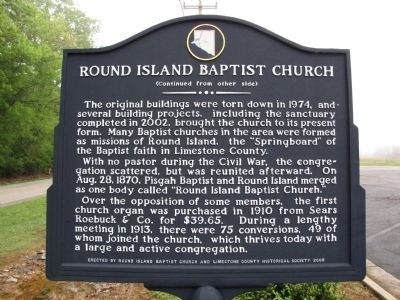
| On Old Federal Road (County Road 8), on the right when traveling west. |
| Near Old Federal Road (County Road 8) 0.1 miles west of Deer Run Trail, on the left when traveling west. |
| On Lee Highway/John T. Reid Parkway (U.S. 72 at milepost 109) at Brock Road, on the right when traveling west on Lee Highway/John T. Reid Parkway. |
| On Huntsville Highway (U.S. 231/431) at Hunter Road, on the left when traveling north on Huntsville Highway. |
| On Holmes Avenue at Lincoln St., NE on Holmes Avenue. |
| On Poplar Avenue NW at Yukon Street NW, on the right when traveling west on Poplar Avenue NW. |
| On Ivy Avenue SW at SW 1st Street, on the right when traveling south on Ivy Avenue SW. |
| Near Church Street Southwest south of Clinton Avenue West. |
| On Northside Square at Eastside Square, on the left when traveling west on Northside Square. |
| On Front Street close to Church Street. |
| On South Cedar Avenue at East Whitfield Street, on the right when traveling north on South Cedar Avenue. |
| On Military Street South (U.S. 278) at State Route 17, on the right when traveling south on Military Street South. |
| On Old Indian Mound Road, 0.2 miles east of U.S. 278, on the left when traveling east. |
| On North Brindlee Mountain Parkway (State Highway 53) at North Main Street, on the right when traveling north on North Brindlee Mountain Parkway. |
| On Florida Short Route/Gunter Avenue (U.S. 431) at Lurleen B Wallace Drive, on the right when traveling south on Florida Short Route/Gunter Avenue. |
| On Gunter Avenue (U.S. 431) at Court Street, on the left when traveling south on Gunter Avenue. |
| On Florida Short Route/Gunter Avenue (U.S. 431) at Lurleen B Wallace Drive, on the right when traveling south on Florida Short Route/Gunter Avenue. |
| On North Craft Highway (U.S. 43) at Viaduct Road, on the right when traveling north on North Craft Highway. |
| On Iberville Drive north of Cadillac Avenue, on the left when traveling north. |
| On St Francis Street, on the right when traveling west. |
| On Dauphin Street west of South Claiborne Street, on the right when traveling east. |
| On Superintendents Drive at Coy Smith Highway (Alabama Route 96), on the right when traveling west on Superintendents Drive. |
| On East Coy Smith Highway (County Road 96) at Superintendents Drive, on the left when traveling west on East Coy Smith Highway. |
| On Old Highway 43 at Military Road (County Road 96), on the left when traveling south on Old Highway 43. |
| On Conecuh County Road 5 (County Road 5) at Burnt Corn Loop, on the right when traveling south on Conecuh County Road 5. |
| On Old Federal Road (County Road 5) at County Road 15, on the right when traveling south on Old Federal Road. |
| On U.S. 84 at Old Fort Claiborne Road, on the right when traveling west on U.S. 84. |
| On U.S. 84 at Grain Elevator Road and Lena Landegger Highway, on the left when traveling west on U.S. 84. |
| On U.S. 84 at Old Fort Claiborne Road, on the right when traveling west on U.S. 84. |
| On Alabama Route 21 at milepost 19 at H-Kyle Road, on the right when traveling north on State Route 21. |
| Near West Hickory Street at Chennault Circle when traveling west. |
| On Dexter Avenue at South Court Street, on the right when traveling east on Dexter Avenue. |
| Near Water Street west of Whitman Street, on the right when traveling west. |
| Near North Bainbridge Street at Dexter Avenue, on the right when traveling south. |
| On Wares Ferry Road (County Route 64) 0.4 miles east of Dozier Road, on the left when traveling east. |
| On Water Street at Commerce Street, on the right when traveling east on Water Street. |
| On Maxwell Boulevard east of North Holt Street, on the right when traveling west. |
| Near North Bainbridge Street at Dexter Avenue. |
| Near Water Streer at Commerce Street, on the right when traveling west. |
| On Walker Street at Shady Street, on the right when traveling south on Walker Street. |
| On Federal Road at Cloverfield Road (County Route 24), on the right when traveling south on Federal Road. |
| On Cain Street Northeast west of Ferry Street Northeast, on the left when traveling west. |
| Near Oak Street north of Market Street. |
| Near Oak Street north of Market Street. |
| On Wheeler Wildlife Boat Launch north of Alabama Route 67, on the right when traveling north. |
| Near Oak Street north of Market Street when traveling north. |
| Near Oak Street north of Market Street. |
| Near Oak Street north of Market Street. |
| On Alabama Route 130, 1.7 miles west of County Road 9, on the right when traveling west. |
| On U.S. 231, 0.3 miles north of Monticello Drive, on the left when traveling north. |
| On Rock Mills Road (Alabama Route 22) at Bacon Cove Road (County Road 75), on the right when traveling east on Rock Mills Road. |
| Near County Route 165, 2.3 miles south of Nuckols Road (Road 39). |
| Near Unnamed Road, 0.2 miles east of Alabama Road 165 when traveling east. |
| Near Unnamed Road, 0.1 miles east of Alabama Route 165 when traveling east. |
| On Unnamed road, 0.2 miles east of Alabama Route 165, on the right when traveling east. |
| Near Old Federal Road east of Alabama Route 165, on the left when traveling east. |
| Near County Highway 165, 2.3 miles south of Nuckols Road (Road 39). |
| Near U.S. 165. Reported damaged. |
| Near County Route 165, 2.3 miles south of Nuckols Road (Road 39). |
| Near County Road 165, 2.3 miles south of Nuckols Road (Route 39). |
| Near County Road 165 south of Nuckols Road (Route 39). |
| Near Alabama Route 165, 2.3 miles south of Nuckols Road (Route 39). |
| Near County Route 165, 2.3 miles south of Nuckols Road (Road 39). |
| On Old Federal Road, 0.2 miles east of Alabama Route 165, on the left when traveling east. Reported unreadable. |
| On North Uchee Road (County Road 22) 0.4 miles east of Foster Road (County Road 7), on the left when traveling east. |
| Near Dillingham Street at Brickyard Road (Route 61). |
| Near 13th Street at 3rd Avenue, on the right when traveling east. |
| On Dillingham Street at Brickyard Road (Route 61) on Dillingham Street. |
| On Brickyard Road (County Route 61) 2 miles south of Kadlin Drive, on the left when traveling south. |
| On Brickyard Road at State Docks Road, on the left when traveling south on Brickyard Road. |
| Near Dillingham Street at Brickyard Road (Route 61). |
| Near Dillingham Street, 0.1 miles north of Brickyard Road, on the left when traveling east. |
| Near Dillingham Street at Brickyard Road (Route 61). |
| Near 13th Street south of 3rd Avenue, on the right when traveling east. |
| On Brickyard Road (County Road 61) 2 miles south of Kadlin Drive, on the left when traveling south. |
| On Longview Street at Jackson Street, on the right when traveling north on Longview Street. |
| On Longview Street at Jackson Street, on the right when traveling north on Longview Street. |
| On Longview Street at Jackson Street, on the right when traveling north on Longview Street. |
| Near Chelsea Road (County Road 47) near County Road 39. |
| On 6th Avenue at Court Street West, on the left when traveling east on 6th Avenue. |
| On State Highway 144 at Valley Drive, on the right when traveling north on State Highway 144. |
| On State Street (Alabama Route 116) at McKee Street (Alabama Route 39), on the right when traveling south on State Street. |
| On Washington Street South at Franklin Street, on the right when traveling north on Washington Street South. |
| On Lafayette Street (U.S. 11) at Franklin Street, on the right when traveling south on Lafayette Street. |
| On Plant Road (Alabama Route 235 at milepost 2), on the left when traveling north. |
| On U.S. 280 at Childersburg Fayettville Highway (State Highway 76), on the right when traveling south on U.S. 280. |
| Near DeSoto Caverns Pkwy (State Highway 76). |
| On 1st Street Southwest (State Highway 76) at 6th Avenue Southwest, on the right when traveling east on 1st Street Southwest. |
| On Fort Williams Street, on the right when traveling east. |
| On South Broadway Avenue (State Highway 21) at Goodwater Highway (County Road 511), in the median on South Broadway Avenue. |
11629 entries matched your criteria. Entries 201 through 300 are listed above.
⊲ Previous 100 —
Next 100 ⊳