Adapting to Alcoves To level the sloping alcove floor, the Anasazi filled in behind retaining walls. The altered floor not only supported rooms but also provided working space and a safe play area for children.
Oak Tree House appears to . . . — — Map (db m71209) HM
There is an enormous gap between identifying pithouse features—the hollows and scattered stones—and visualizing the inhabitants’ daily lives. Set in the four corner post holes, timbers supported a ceiling that was probably head-high. . . . — — Map (db m71203) HM
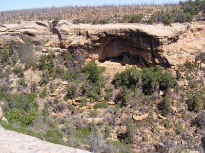
Mesa-top and Alcove Living Although the Puebloan used the cliff alcoves throughout the entire time they lived in Mesa Verde, the cliff dwellings themselves were not built until the final 75-100 years of occupation. For over 600 years these . . . — — Map (db m71207) HM
There are about 600 alcove sites in Mesa Verde National Park. About 90 percent contain fewer than 11 rooms. At least one-third are simply one room structures, probably storage rooms for a nearby cliff dwelling. There are only about a dozen cliff . . . — — Map (db m153353) HM
The cliff dwelling across the canyon is named for Mary Tileston Hemenway who funded the first scientific archaeological expedition in the southwest. At the time cultural objects were often removed for souvenirs or profit. Hemenway's support provided . . . — — Map (db m153346) HM
Montezuma Valley (below you) and Mesa Verde (where you now stand) were once part of the Ancestral Pueblo homeland. Between 600 and 1280 CE*, hundreds of villages and farming communities thrived on the mesas, plateaus, and canyons that form this . . . — — Map (db m153343) HM
The move to the alcoves began around 1200 CE and by mid-century, there were more than 30 cliff dwellings in the Cliff and Fewkes Canyon neighborhood. Several are visible from here. Imagine these canyons filled with the sights and sounds of a . . . — — Map (db m153352) HM
Children born in one of these cliff dwellings in 1225 CE experienced many changes in
their lifetime. Over the course of roughly 75 years, they and their families witnessed the migration from mesa top villages into alcove communities; a significant . . . — — Map (db m153350) HM
The Utes and their ancestors migrated into South Park annually, arriving in the spring and staying into late fall.
They traveled a regular circuit, following the large game herds until the mountain seeds and berries ripened. During the winter, . . . — — Map (db m153282) HM
Bent's New Fort links the continuous story of
southeastern Colorado-from the development of the
Santa Fe Trail, to the occupation of Bent's Old Fort, to
the construction of Fort Wise, to the disintegration of
human relationships following the . . . — — Map (db m181871) HM
”My people roamed all over this country… over these mountain passes. They gathered to hunt buffalo and went back to the lower country when winter was approaching.” ~Eddie Box Senior Southern Ute Tribe At the dawn of history, . . . — — Map (db m163893) HM
These stone structures appear to be the remains of historic labor camps. Occupied during the late 19th Century, they were used as temporary dwellings by immigrant workers completing railroad construction in Ten Mile Canyon.
The architecture . . . — — Map (db m120009) HM
Women's stories figure prominently in the early frontier days of Florissant.
Charlotte Hill homesteaded here in the late 1800s. Married at age 13, she raised seven children, ranched with her husband, and pursued her avocation of collecting fossils. . . . — — Map (db m240616) HM
Adjacent to this site stood the, two-room school where on, July 10, 11, & 12, 1934, the first Stone Age Fair was held. In 1935, over 10,000 people from 41 states attended; President F. D. Roosevelt sent a congratulatory telegram; Will Rogers sent . . . — — Map (db m119893) HM
Height: 4 feet
Weight: up to 33 lbs
Wingspan: 10 to 12 feet
Males: brown eyes,
Females: red eyes and lack the head crest Or carbuncle.
Lifespan: 50 years in the wild. Over 75 years in human . . . — — Map (db m230842) HM
Bears have fascinated and inspired humans since our ancient ancestors first explored the wild world around them and gazed at the skies above.
They connect us deeply with the natural world around us.
Inspired by the rising sun, Sun bears . . . — — Map (db m230880) HM
For thousands of years, tribal people around the world have relied on certain animals to provide them with meat, milk, shelter, tools and transportation. Middle-Eastern tribes have relied on Dromedary camels, northern Eurasian tribes have relied . . . — — Map (db m230898) HM
Size: 1.5-2.5 feet at shoulder
Weight: 66-88 pounds
Lifespan: Up to 9 years
Habitat: Dry thorn forests, plains and marshes of South America
Diet: Cacti, tubers, fruits, flowers
Wild cattle originated in North Africa, Europe and Southern Asia. Domestic cattle are found worldwide.
Cattle are large, hoofed mammals. They graze on rangelands throughout the world.
Cattle breeds vary in color, shape and size. The . . . — — Map (db m230940) HM
People have kept goat herds for more than 10,000 years.
They originated in Central Asia and are now found worldwide.
The many breeds of domestic goats vary in color, shape and size. The largest breeds can weigh up to 250 pounds, while . . . — — Map (db m230937) HM
Size: no taller than 34 inches, measured at the top of the shoulders
Weight: between 150 and 350 pounds
Lifespan: from 25 to 35 years
Found in many nations, particularly in Europe and the Americas
Our myths and legends about wolves vary from reverence to fear.
753 B.C.
Mother to mythic heroes
According to Roman mythology. Romulus and Remus were nurtured as infants by a "she-wolf." Romulus founded the city of Rome on the Tiber . . . — — Map (db m230843) HM
Bearly Recognizable:
While bears come in a wide variety of sizes and colors, all bears have some things in common. Large, powerful, well-furred bodies, long snouts with super-sensitive noses, broad paws with sharp claws and tiny tails are . . . — — Map (db m230878) HM
This tidal marsh was once part of a network of wetlands that covered hundreds of acres and extended south to Long Island Sound, east to Ash Creek and west to Pine Creek. For centuries the area's native inhabitants, the Unquowa, fished and . . . — — Map (db m204276) HM
This Viewpoint extends the museum sites of the Connecticut Impressionist Art Trail — Connecticut's Millennium Legacy Trail — to the outdoor settings that artists portrayed at the turn of the 20th century in a manner that came to be called . . . — — Map (db m227311) HM
The first farmers in this area were the Indigenous people who lived along the Connecticut River. Artifacts from this first farming community were uncovered at the Morgan Trench archaeological dig in the rock Hill Great Meadows. Surface finds, . . . — — Map (db m230804) HM
Who Lived Here ?
James Chaugham (a Native American who was, according to his granddaughter, a member of the Narragansett Tribe) and his wife, Molly (of European descent), lived in a village located here for fifty years,
in what became Peoples . . . — — Map (db m102323) HM
You are now looking into the Lighthouse Village cemetery. The unmarked, upright field stones
designate the final resting places of many who lived in the community, including the founding couple,
James Chaugham, a Native American, and Molly . . . — — Map (db m102325) HM
The residents of the Lighthouse community were largely self-sufficient
when it came to their subsistence. Bone fragments found in their
fireplaces show that they ate deer and small wild game. Gun flints (used
in flint-lock rifles) and gun . . . — — Map (db m112198) HM
Native Peoples
Fort Saybrook Monument Park consists of nearly 18 acres, about 11 of which are marshland, and borders the Connecticut River called by Native Americans "quineteckut" or "long, tidal river." Prior to the arrival of Europeans in . . . — — Map (db m227286) HM
hammonasset Beach State Park is named for the spirit and memory of the Hammonassett Tribe who originally inhabited this land. Hammonassett means "where they dig holes". They fished, farmed, harvested shellfish, and hunted this entire area. . . . — — Map (db m245142) HM
Athena Stands Watch
Bronze 2018
Renée Rhodes
Athena, Greek goddess of wisdom and protector of cities, is the watch-keeper for the Thames River port of New London. New London & the Sea Athena welcomes visitors to Nameaug, or "fishing . . . — — Map (db m217033) HM
The Mohegan and Pequot people of southeastern Connecticut and their ancestors have used the coastal resources of eastern Long Island Sound for thousands of years. Native people made ocean-going canoes to harvest fish, trade, and visit with their . . . — — Map (db m48330) HM
Even before New London was settled by the English in 1646, the area was known for its easy access to the sea and its natural resources. The native Pequots and Mohegans called the river the Great River of the Pequot or the Mohegan River. The . . . — — Map (db m216868) HM
Quahogs are also known as littlenecks, cherrystones or hard clams. The word quahog is of Algonquian Indian origin and is pronounced "koh-hog". Native Americans used . . . — — Map (db m227229) HM
This is a garden of perennials used and valued by African American individuals and communities. Enslaved people brought from Africa to work in households and plantations in the Americas brought their own traditional knowledge with them, and in . . . — — Map (db m227094) HM
Whaling voyages created opportunities for cultural exchange between crew from all corners of the globe. Sailors used whaleships to emigrate when whaling vessels routinely stopped and picked up crew in remote places such as Valparaiso, Cape Verde, . . . — — Map (db m227049) HM
For generations, the tribes of Quinnehtukqut (Connecticut) have been connected to the animals and fish of the sea. This connection led them to become boat builders.
What is a mushoon?
Commonly known as a dugout canoe in the . . . — — Map (db m227099) HM
The L.A. Dunton has belonged to Mystic Seaport Museum since 1963 and was recently hauled out for a major, multiyear restoration.
Visit the Shipyard Gallery for updates and to learn more about restoring historic ships and tools and . . . — — Map (db m227127) HM
Native Americans of the Northeastern Woodlands
It is widely believed that the first inhabitants of the Americas date back 15,000 years ago. That migration spread across North America and one group became known as the Lenni Lenape. As they . . . — — Map (db m238424) HM
The Pencader Heritage Museum and Research Center highlights artifacts that reflect life in Pencader Hundred from the Colonial Era through the Afghanistan War. Our rotating displays reveal the rich heritage to be found in this area. We have items of . . . — — Map (db m156798)
Total Pencader Population: 2,132 100%
Number of Free Black Residents in Pencader:201 9% of Total Population
Number of Free Black Persons Living in Free Blk. . . . — — Map (db m238418) HM
On the ground before you are the archaeological remains of the original Iron Hill School #112C. The one-room school was constructed for the education of African-American students in the Iron Hill area. Archival records suggest that the school . . . — — Map (db m238419) HM
1. a natural hill that formed millions of years ago?
2. a Native American burial mound?
3. a spoils pile from iron mining?
4. an abandoned charcoal furnace or collier's hut used by Abbington Iron Works? . . . — — Map (db m238414) HM
This owl lives in underground colonies called "prairie-god towns" made by burrowing mammals. They share tunnels with prairie dogs, armadillos, foxes, skunks, and more. Do you see the tunnels our keepers made in this exhibit?
Cowboys . . . — — Map (db m191238) HM
Numbers in Decline
Red panda populations have dropped by as much as 40% in the last 50 years, with fewer than 10,000 of this vulnerable species thought to remain in the wild.
Habitat Loss
The red panda habitat has been fragmented . . . — — Map (db m191219) HM
The sweet acorns were a very important Native American food. The wood is so strong it protected the U.S.S. Constitution "Old Ironsides" from the cannonballs of the Revolutionary War. — — Map (db m216044) HM
The roots of Pachysandra have been used in herbal teas; in the Cherokee culture; as an additive for inflammation and digestive issues. — — Map (db m191262) HM
King of the Caribbean Sea the helmets inner whirls were chipped out and used as bowls in the islands. Helmets are sometimes used for cameo cuttings of jewelry. — — Map (db m232947) HM
In the time of Atlantis & King Kamehameha the great Shell Shop was lost during a hurricane. Just recently the ruins were found right here in Rehoboth Beach where the Sea Shell shop is a family generation business. — — Map (db m232943) HM
Spanish gold doubloon and silver "pieces of eight" can be found from the many Spanish ships that wrecked along our shore entering the Delaware Bay. — — Map (db m232968) HM
Murexs have special coloring in all shades of pastels. They are one of the more intricate in the shell kingdom. A smaller murex was once used to extract purple dye for royalty clothes. — — Map (db m232971) HM
The sand dollar wears its bones on the outsides. It has a famous legend and it goes like this.
Upon this odd shaped sea shell, a legend grand is told.
About a precious life, A wondrous tale of old.
The center marking . . . — — Map (db m232965) HM
The sand dollar wears its bones on the outsides. It has a famous legend and it goes like this.
Upon this odd shaped sea shell, a legend grand is told.
About a precious life, A wondrous tale of old.
The center marking . . . — — Map (db m232967) HM
When at the beach, women of the early 20th century wore woolen bathing attire that covered most of their bodies. When wet, the suits were heavy, and it became difficult to leave the surf and get back onto the beach without help. The women of the . . . — — Map (db m198811) HM
Tikis come from the Polynesian and Hawaiian Islands. They represent their old traditional beliefs. There are 100's of styles and many are known to bring you good luck. — — Map (db m232963) HM
Tritons and Pink Conchs have long been known to be cut on the end and used as horns. To this day many primitive island tribes still communicate with the shell. — — Map (db m232964) HM
Along our beautiful white beach you can find wampum money which is broken Quahog shells. The broken purple shells were polished and once used as a trade of money by shore Indians. — — Map (db m232946) HM
A very delicate shell with royalty value, as it was once collected by Kings and Queens. There are several varieties of this shell in many oceans and is often called the spiral staircase shell. — — Map (db m232970) HM
The Penobscot tribe of Maine believed this plant to have protective powers; they chewed a piece of the aromatic root to ward off disease when traveling or used steam from the root to prevent illness. — — Map (db m144624) HM
Tribes of the Northwest made a paste with the ashes of this fern to darken and add luster to their hair. A decoration (or extraxt) was given for chest complaints. — — Map (db m235709) HM
Native Americans used the stalk for fiber in the same way Europeans used their hemp plant, Cannabis sativa. Indian Hemp is superior, however, because it is stronger and lasts longer.
This herb is poisonous. — — Map (db m144567) HM
Crushed leaves were applied to cool bruises, burns and swellings. Seeds, or the juice from the leaves, taken with honey, were considered a diuretic. — — Map (db m235711) HM
Current research has confirmed traditional Chinese use as a malaria preventative and cure. The active constituent, artemisinin, is more potent than the standard malaria drug treatment, chloroquine. Other studies indicate an antibiotic effect on . . . — — Map (db m235691) HM
The Chippewa used this herb to season food and chewed the root to relieve indigestion. The Iroquois used the roots to preserve meats. — — Map (db m144574) HM
This plant was one of the most important medicines of the Menomini. The pulverized root was used for cuts and wounds, and was mixed with other roots for additional cures.
This herb is potentially toxic if taken internally. — — Map (db m144617) HM
The Cherokee used the leaves and woody stems to make a blue dye. The Mohegan bathed their cuts and wounds with an infusion of the plant. This entire herb is toxic. — — Map (db m144568) HM
The Cherokee used the root of this herb to make a strong diuretic for urinary and bladder complaints. The seeds of this plant are poisonous. — — Map (db m144619) HM
This herb was used by north-central tribes to assure quick delivery and to ease menstrual cramps. It was also called squawroot and papoose root. — — Map (db m235704) HM
The Louisiana Choctaws chewed the bitter bark of this shrub to relieve toothaches. They also drank a strong decoction (extract) of it to treat diarrhea.
The leaves have poisoned grazing animals. — — Map (db m144625) HM
Bergamot's rind releases a highly fragrant essential oil that was used in perfumery as early as the 18 century in Cologne, Germany, where it was a key component of the original Eau de Cologne. It also lends its distinctive scent to . . . — — Map (db m207111) HM
The Cherokee used the wood of this tree for building and carving. Early settlers in the southern Appalachians used the root bark for dye and the yellow heartwood for gunstocks. Today, yellowwood is popular in urban settings for its resistance to . . . — — Map (db m144694) HM
The leaves of this herb were thrown on fires by the Potawatomi of Michigan to create a smudge to deter mosquitos. The Ojibwe used the leaves for a tea to cure stomach cramps. — — Map (db m144611) HM
The seeds were drunk in wine by scorpion-bite victims. It was said that the plant, when placed against a scorpion, would cause temporary paralysis in the animal. Plant is poisonous. — — Map (db m235717) HM
The stigmas are used in yellow food coloring and flavoring. Chemical analysis of ancient linens and mummies' winding sheets confirms its use as a dye. Today, it is used more as a spice and in cosmetics than as a textile dye. — — Map (db m144652) HM
The flower petals contain a very strong dye, which on wool yields colors ranging from yellow and bronze to red, depending on the mordant and length of time simmered. Wild mountain dahlias were a source of red dye used by the Aztecs. — — Map (db m207114) HM
Early Mediterranean peoples used the root, boiled with wine and beaten until waxy as a salve for chapped skin. Little "worms found in the seed head were put in a purse and hung around the neck to cure fevers. — — Map (db m235720) HM
The Plains Indians considered this herb to be one of the most important medicinal plants. Its root was the universal antidote for snakebites and all kinds of venomous bites and stings. — — Map (db m144605) HM
In Dioscordes' time the young leaves of this prickly plant were pickled in brine and eaten as a pot herb. A drink of 'Eryngum' root diluted in honey liquor was said to cure epilepsy. — — Map (db m144654) HM
The Meskwaki used the fresh outer bark, pounded into a poultice (compress), to heal facial sores. They steeped the inner bark to make an eye lotion. — — Map (db m144577) HM
The Menomini used a decoction, or extract, of the root to treat the genitourinary tract. The Potowatomi made a poultice of fresh leaves to treat burns, and the Ojibwe bathed babies in a solution of the root to strengthen them. — — Map (db m144569) HM
The northern Iroquois used the leave to make a tea that was considered a tonic and cure for colds and fevers
This herb may damage the liver. — — Map (db m144612) HM
This plant was used in broth to help people lose weight. The leaves were also used to flavor fish dishes and to help babies who had indigestion. — — Map (db m235713) HM
The Meskwaki of Minnesota pounded the astringent root of this geranium in an animal bladder to make a poultice for hemorrhoids. — — Map (db m144596) HM
The upper root drunk with wine provoked lust, Dioscorides said, and the lower root took away lust. Mashed with frankincense and wine, it was used to draw out splinters. — — Map (db m207112) HM
According to Cherokee belief, the roots of sneezeweed and Veronica noveboracensis steeped in warm water acted as a contraceptive by preventing menstruation for two years. — — Map (db m144614) HM
Young leaves of this plant were eaten in salads. Medicinally, it was considered useful against scurvy, a disease brought on by a lack of Vitamin C. — — Map (db m235712) HM
The root, a powerful astringent, was used by Choctaw, Chickasaw and Creek of the Southeast when conditions required an astringent or "puckering" medicine. — — Map (db m144613) HM
Barley is believed to be the first grain used for fermenting into beer. Due to its high levels of starch-converting enzymes and its tolerance of drought, cold, and poor soil conditions, barley is considered to be a distiller's "best friend". It is . . . — — Map (db m235684) HM
Native American medicinal uses of the root included treatment of the eyes and skin and for cancers and venereal diseases. The yellow root provided dye.
This plant should be avoided during pregnancy. — — Map (db m144572) HM
Yaupon was a common drink of the Southeastern tribes, taken mainly for its emeting (vomit-inducing) action, which was a means of purification.
The fruit is poisonous. — — Map (db m144604) HM
The common name for this plant comes from its purported use as a Native American smoke. It was used by the Seneca as an emetic (vomit-inducer) and for coughs.
The whole plant is poisonous. — — Map (db m144621) HM
American Indians used the leaves of this small tree to make a medicinal tea for the treatment of chills, colds, and other ailments. Early American physicians used it as a quinine substitute as well as to treat gout, rheumatism, and respiratory . . . — — Map (db m144692) HM
2829 entries matched your criteria. Entries 201 through 300 are listed above. ⊲ Previous 100 — Next 100 ⊳