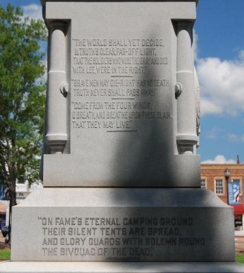
South:
Ship's Anchor
1861-1865
"The world shall yet decide,
In truth's clear, far-off light,
That the soldiers who wore the gray, and died
With Lee were in the right!"
----------
"Brave men may die - right has no . . . — — Map (db m171618) HM WM
The heart of Abbeville's Historic District is the magnificent tree-shaded Court Square. Located here is the replica of the original Confederate Monument erected in August, 1906 by the Daughters of the Confederacy, an old iron bell once used as . . . — — Map (db m12097) HM
Burt-Stark House When Jefferson Davis, President of the Confederacy, left Richmond after its fall in April 1865, he traveled south, trying to reach and rally the remnants of his army. On May 2, he spent the night at the home of Col. Armistead . . . — — Map (db m10564) HM
Northwest
"Lord God of Hosts, Be With Us Yet,
Lest We Forget, Lest We Forget
On the hillside in the rear of this memorial on November 22, 1860, the first organized secession meeting was held.
On that day the ancient . . . — — Map (db m11691) HM
Historical Bicentennial marker
in memory of
Henry McNeal Turner
1834-1915
Birthplace: Newberry, South Carolina - Boyhood home: Abbeville, South Carolina
Missionary Pioneer to South Africa, Liberation Theologian, Social and Political . . . — — Map (db m20249) HM
This 1888 Queen Anne house was the home of Gen. Samuel McGowan (1819-1897) until his death. McGowan, a lawyer, Confederate general, and jurist born in Laurens Co., had moved to Abbeville in 1841. He was an officer during the Mexican War and in the . . . — — Map (db m21732) HM
This house, built ca. 1786, is thought to be the oldest house in Abbeville. It was built as a two-story log building by John Quay, who also ran a tavern here. He sold it ca. 1798 to James Wardlaw (1767-1842) and his wife, Quay's stepdaughter Hannah . . . — — Map (db m86812) HM
One of the first organized mass meetings held here on November 22, 1860, to launch South Carolina's secession from the Union. Judge A.G. Magrath of Charleston, urged "immediate action on the part of South Carolina at any & every hazard", followed by . . . — — Map (db m11686) HM
[Front]:
On November 22, 1860, a mass meeting on this site was one of the first held in the South after Abraham Lincoln’s election as president on November 6. A procession from the town square, numbering 2,000 to 3,000, made its way to a . . . — — Map (db m41700) HM
Queen Anne style Architecture Built in 1888
Once Owned by Confederate Gen. Samuel McGowan and by WWII Gen. W.E. Barksdale
Donated by J.D. Bundy in 1989 to the Abbeville County Historical Society
Now serves as Headquarters for the Society . . . — — Map (db m16129) HM
This tablet was placed here to commemorate the last meeting of the Confederate States Cabinet which was held in the Burt House near by directly in front of this stone.
The following cabinet members were present:
Jefferson Davis, President . . . — — Map (db m73949) HM
The Greek Revival residence of Thomas Chiles Perrin (1805-1878), prominent Abbeville District lawyer, planter, businessman, and politician, stood here from 1858 until it burned in 1877. When completed the house was described as "one of the finest . . . — — Map (db m9358) HM
Aiken, chartered in 1835 and the county seat of Aiken County since its creation in 1871, was an early stop on the railroad line from Charleston to Hamburg. It was named for William Aiken (1779–1831), the first president of the S.C. Canal and . . . — — Map (db m9640) HM
(South Face)
They gave their all in defense of
Home, Honor, Liberty and the
Independence of their native land
They fought the patriots fight
They kept the faith of their fathers
Forever honored
And forever mourned
. . . — — Map (db m17047) HM
Near this spot on February 11, 1865
was fought one of the final Confederate
victories of the War Between The States.
Federal Cavalry commanded by Major
General Hugh Judson Kirkpatrick were
attacked by Confederate Cavalry
commanded by . . . — — Map (db m10061) HM
In Memory of
the Confederate
soldiers who lost
their lives in
defense of Aiken,
Feb. 11, 1865
Erected by the Memorial
Association 1911
— — Map (db m88573) HM
This mill, the largest textile mill in antebellum S.C., was chartered in 1845 and opened in 1847. It was founded by William Gregg (1800–1867), a Virginia native and advocate of industrial development who chose this site for its proximity . . . — — Map (db m9763) HM
This is the site of Camp Butler, a
Confederate "camp of instruction"
that operated from the spring to
the fall of 1861, in what was then
Barnwell District. New companies,
organized as independent companies,
or in state regiments, were . . . — — Map (db m63281) HM
War Between The States
1861 — 1865
Let the stranger who may in
future times read this
inscription recognize that
these were men whom power
could not corrupt, whom death
could not terrify, whom
defeat could not dishonor, . . . — — Map (db m31127) WM
Original site of Allendale, named
for its first postmaster, Paul Allen,
in 1849. Sherman's troops under
Gen. Kilpatrick camped here.
Town moved to present site by
1873. — — Map (db m15914) HM
(Barker's Mill side of marker):
Barker's Mill, which stood here on
Jackson Branch, was a grist mill
owned by William Ransome Barker
(1816-1869), a planter in what was
then Barnwell District. Barker moved
to this are in the . . . — — Map (db m7176) HM
[North]:
(Palmetto Tree)
(Crossed swords in scabbards with a laurel wreath - representing the cavalry.)
(Confederate Battle Flag)
"Though conquered, we adore it!
Love the cold dead hands that bore it!"
. . . — — Map (db m155713) HM
The location of the Anderson County Courthouse Annex on the corner of Fant and River Street has unique significance to Anderson's history. The site is the location of the 1865 federal encampment of the First Maine, 33rd Regiment, United States . . . — — Map (db m19838) HM
Located 1.09 miles northwest, this cemetery marks the original site of Hopewell Baptist Church which was constituted in 1803. The cemetery contains graves of Revolutionary and Confederate veterans. Some graves are marked by field stones with . . . — — Map (db m10724) HM
Though not engaged in actual warfare since the Revolutionary War, when it was used by both the American and British Army, this old cannon has had much to do with the making of South Carolina history. It came into this section, first in 1814, in . . . — — Map (db m21310) HM
In memory of Honea Path veteran
who gave their lives for their country
and in honor of those who served.
War Between the States
[Left Column}: Reuben B. Kay, George Ballentine, James L. Bagwell, Jr., Pleasant Bagwell, John J. . . . — — Map (db m10761) HM
This plantation on the old road to Pickensville has been the home of several prominent S.C. families. Many of its owners were members of the Pendleton Farmers Society, and during the nineteenth century, studies, experiments, and advances in . . . — — Map (db m9649) HM
Born Charleston, S.C., 1824.
Graduated West Point 1845.
Brigadier General, C.S.A., 1861.
Commanded 3rd Brigade,
Army of the Shenandoah.
July 21, 1861, at Manassas, Va., where he gave Gen. T.J. Jackson the name "Stonewall." Mortally . . . — — Map (db m39001) HM
[Front]:
Confederate Brig. Gen. Clement H. Stevens (1821-1864) is buried nearby in the Bee family plot. Born in Connecticut, Stevens moved to S.C. after his father's death in 1836. In 1861 he invented the first ironclad battery, which . . . — — Map (db m9680) HM
Sandy Springs Camp Ground: This Methodist camp ground named for the large spring nearby, dates to 1828, when a fifteen-acre site was purchased from Sampson Pope for $45. Early meetings were under a brush arbor until a central wooden shelter . . . — — Map (db m10785) HM
On May 1, 1865, cadets from the Arsenal Academy at Columbia, under Capt. John Peyre Thomas, who were en route from Greenville to Newberry to be disbanded, met a band of Stoneman's raiders near here in one of the last engagements of the war, which . . . — — Map (db m8395) HM
A South Carolina "Spa"
In 1852, following the discovery of a "healing" spring and the announcement that the railroad was going to be running through the area, the Town of Williamston was chartered. In time, lots were sold for houses to be . . . — — Map (db m15719) HM
Hooten- Black House & Bamberg's National Historic District
The Hooten- Black House is the hub of art and history in Bamberg County where you will find changing art exhibitions,
concerts, and lectures on Bamburg County history. The Hooten- . . . — — Map (db m32840) HM
(side 1)
In 1801 John Holman constructed a bridge spanning the South Fork of the Edisto River at a site previously known as Tyler's Ferry, about 1/2 mi. N. of here. Two acts of the General Assembly granted Holman the right to charge a toll . . . — — Map (db m110750) HM
Eleven years after the battle of Rivers Bridge,
a group of local young men formed the Rivers
Bridge Confederate Memorial Association and
reburied the Confederate dead here, about a
mile from the battlefield. The Memorial
Association began to . . . — — Map (db m15671) HM
Battle At Rivers Bridge
On February 2 ~ 3, 1865, as Gen. W.T. Sherman's
Federals advanced toward Columbia, units of
Gen. F.P. Blair's XVII Corps attempted to cross
the Salkehatchie River at Rivers Bridge. The
Confederate defenders . . . — — Map (db m7708) HM
Invasion! In January 1865, Gen. William Tecumseh Sherman's army of 60,000 Union soldiers invaded South Carolina. Its goals: to link up with Ulysses S. Grant's forces opposing Robert E. Lee's Confederates in Virginia and destroy the South's . . . — — Map (db m7437) HM
Crucial Routes to the Heart of the State: The Salkehatchie River Crossings As Sherman's right wing- about 28,000 men underGen. Oliver Otis Howard- advanced up the south side of the Salkehatchie, Gen. Lafayette McLaws' Confederate division . . . — — Map (db m7440) HM
Dig In Part of McLaws' division protected the middle crossing of the Salkehatchie at Rivers Bridge. This small force, consisting of a brigade of Georgia infantrymen, South Carolina cavalrymen and four cannons of the South Carolina Light . . . — — Map (db m7441) HM
"This Indescribably Ugly Salkehatchie " At Rivers Bridge the Salkehatchie flowed though a swamp a
half mile wide. The only road through it was a narrow earthen causeway with multiple wooden bridges. The Confederates hoped the thick swamp and . . . — — Map (db m7455) HM
Attack! Gen. Joseph A. Mower's Union division advanced rapidly to Rivers Bridge on the afternoon of Feb. 2 and charged down a narrow causeway. Confederate cannon fire stopped the attack and forced the Yankees to take cover in the cold swamp. The . . . — — Map (db m7456) HM
A Running Battle on the River Road On Feb.2, Union troops moved up the road on the opposite bank of the Salkehatchie, fighting a running battle with the Confederate cavalrymen who tried to slow their advance. Among the casualties was Pvt. John . . . — — Map (db m7457) HM
A Vulnerable Stronghold The Confederates were confident they could stop another head-on Union assault. But they feared for the safety of their flanks, knowing they did not have enough men to resist attacks that might strike the ends of their . . . — — Map (db m7458) HM
Death and Defeat
As Mower's troops flanked the Confederate right, another Union division crossed several miles downstream to flank the Confederate left. Under a smokescreen created by a rapid artillery and rifle volleys, the Southerners . . . — — Map (db m7464) HM
The End is Near
The Union Victory broke the main Confederate line of defense in lower South Carolina. McLaws' troops retreated to another line behind the Edisto River about 20 miles northeast of here, then continued to fall back as . . . — — Map (db m7467) HM
Here on February 3, 1865, the 17th U.S. Army Corps led by Major General Joseph A. Mower and Lieut. Gen. Giles A. Smith attacked the Confederate division of Major General Lafayette McLaws and forced the crossing of Salkehatchie River, after a gallant . . . — — Map (db m11318) HM
Colleton County
In Memory Of Our
Confederate Soldiers
Who Here Gave Their Lives
In Defense Of
A Righteous Cause
Feb. 3 and 4, 1865 — — Map (db m53729) HM
Most of the Confederates killed here were Georgians,
and most were unknown when they were reburied. But
the local community remembered them as " our
Confederate dead, " the fallen heroes of a common cause. The monument placed over their mass . . . — — Map (db m15650) HM
( Front face )
In Memory
of our
Confederate Dead
who fell in battle at
River's Bridges
Feb. 4, 1865.
(Reverse face ) Soldier's rest, your welfare o'er,
Sleep the sleep . . . — — Map (db m15652) HM
( Left side )
The Legacy of Total War
From January to March in 1865 more than
60,000 Union soldiers led by General
William Tecumseh Sherman marched
across South Carolina. They brought
total war to the state, . . . — — Map (db m15646) HM
(Front text) This church, established 1829 30, was first named Three Mile Creek Church and held early services in a brush arbor 4 mi. W on the Salkehatchie River. In 1839 it moved to this site donated by George Kinard, and was renamed St. . . . — — Map (db m32605) HM
(Front Text) Buford's Bridge, the earliest settlement in what is now Bamberg County, was established as early as 1792, when William Buford maintained a bridge and operated a ferry over the Salkehatchie River. It grew throughout the nineteenth . . . — — Map (db m7644) HM
Our Confederate Dead
(West Face) Who throughout a long
and bloody struggle dis-
played a heroism and de-
votion to duty unsurpass-
ed. If ever equaled in the
annals of war.
(South face)
Who wrung from the great . . . — — Map (db m8657) HM
[Front]
Nearby earthworks at Morris Ford, on the Salkehatchie River, built in the spring 1780 by Loyalists under Ben John. In May, soon after Charleston fell to the British, Capt. John Mumford of the South Carolina militia was killed in . . . — — Map (db m8671) HM
The lifetime of William Gilmore Simms, the preeminent man of letters in the Old South, embraced an era of American history marked by nullification, states rights, secession, war and reconstruction.
He responded to these crises by writing and . . . — — Map (db m95193) HM
Blackville: Town of the Phoenix
Blackville was founded in 1833 as the first overnight stop on the new railroad operated by the S.C. Canal & Railroad Co. It was also the scene of 4 major fires in the late 19th century (in 1865, 1876, 1887, . . . — — Map (db m8656) HM
[Marker Front]:
Boiling Springs Academy was founded by the Boiling Springs Academical Society in 1823, with trustees Hansford Duncan, John Fowke, James Furse, William Gillette, Gideon Hagood, Frederick Hay, Lawrence Hext, James . . . — — Map (db m8666) HM
This Greek revival house was built between 1833 and
1850 and features a wide gable- front form unusual
for the period. John Ashley and then Elijah Willis
owned this land before 1850: the house was likely
built by the Ashley family. Williston, . . . — — Map (db m19640) HM
The 1st South Carolina Volunteer Infantry Regiment
was raised from sea island slaves living around Port
Royal. Elements of the regiment were formed on Hilton
Head in May 1862. In August 1862, the regiment was
reorganized near Beaufort at the . . . — — Map (db m7094) HM
Prior to the Civil War, Beaufort was home to some of South Carolina's wealthiest citizens who had grown rich from the Sea Island Cotton harvested by the people they enslaved. In 1863, after more than a year of US Military occupation, the prewar . . . — — Map (db m227253) HM
Civil War Dead An estimated 700,000 Union and Confederate soldiers died in the Civil War between April 1861 and April 1865. As the death toll rose, the U.S. government struggled with the urgent but unplanned need to bury fallen Union troops. . . . — — Map (db m134423) HM
Four score and seven years ago our fathers brought forth on this continent, a new nation, conceived in liberty, and dedicated to the proposition that all men are created equal.
Now we are engaged in a great civil war, testing whether that . . . — — Map (db m114214) HM
(side 1) The Baptist Church of Beaufort descends from Euhaw Baptist Church on Edisto Island. In 1794 the first meeting house was built on this site. In 1795 Henry Holcombe moved to Beaufort and became the first mission pastor. The Beaufort . . . — — Map (db m133292) HM
(Front Text):
Battery Saxton, constructed here in 1862, was in the second line of earthworks built by Federal troops occupying Beaufort during the Civil War. Laid out by the 1st New York Engineers with the assistance of black laborers, it . . . — — Map (db m6985) HM
Erected in 1798 and rebuilt in 1852, the Beaufort Arsenal was the home of the Beaufort Volunteer Artillery, commissioned in 1802, which had its roots in an earlier company organized in 1776 and served valiantly in the Revolutionary War. The BVA was . . . — — Map (db m5664) HM
1860 -
On November 7,1861 a flotilla of U.S. warships steamed into Port Royal and the "Cotton Kingdom" came to a swift and thunderous end. The planters were forced to flee inland, many never to return, abandoning homes, lands and slaves. . . . — — Map (db m5941) HM
National Cemetery Beaufort National Cemetery was established in 1863. The U.S. Army Quartermaster General's Office laid out the 22 acres in sections that radiate outward from a central plaza to form a half circle. Of the 9,226 interments here . . . — — Map (db m134421) HM
Known for acts of bravery and outstanding leadership in the defense of Beaufort. This Memorial is erected by the Stephen Elliot Chapter of the United Daughters of the Confederacy opposite the home in which this chapter was organized. — — Map (db m5638) HM
Welcome to Reconstruction Era National Historical Park. This unit of the national park system was established in January 2017 to preserve and interpret the resources and complex national stories of Reconstruction — African Americans' quest for . . . — — Map (db m227256) HM
(side 1) This building was built ca. 1896 by the David Hunter Post No. 9, Grand Army of the Republic (G.A.R.) The G.A.R., founded in 1866, was a fraternal society for veterans of the Union army and navy, with white and black posts. David . . . — — Map (db m133383) HM
Maxcy - Rhett House
This house was built circa 1810 for Milton Maxcy (1782-1817), who came here from Massachusetts in 1804. Maxcy and his brother Virgil, who founded a school for young men in Beaufort, later taught at Beaufort College. In the . . . — — Map (db m218490) HM
(Tablet One)
The Governor of the Commonwealth of
Massachusetts Michael S. Dukakis, and
descendant's of the African-American Civil
War Volunteers of the 54th and 55th Infantry
Regiments and the 5th Cavalry Regiment of
Massachusetts, . . . — — Map (db m20211) HM
Born in Stateburg, Sumter County, SC: October 7, 1821
Graduated from West Point: 1842
Served with distinction in Mexican War: 1846-1848
Served at Cavalry School in Carlisle, PA. and wed Sarah Gibson: 1850
With the secession of South . . . — — Map (db m148756) HM
Born a slave in 1839, Robert Smalls lived to serve as a Congressman of the United States. In 1862 he commandeered and delivered to Union forces the Confederate gunboat Planter, on which he was a crewman. His career as a freedman included service as . . . — — Map (db m20144) HM
(Marker Front):
This Episcopal Parish was established by Act of the Assembly June 7, 1712. The first known rector, William Guy, conducted early worship services in homes of settlers. The parish suffered greatly during the 1715 Yemassee . . . — — Map (db m5827) HM
(side 1) This Greek Revival church, built In 1846, dedicated as "St. Peter the Apostle Catholic Church," Is the oldest Catholic church in Beaufort County. Michael O'Connor (1798-1850), a native of Ireland who came to Beaufort In 1822, built . . . — — Map (db m133312) HM
Stephen Elliott Jr. Brigadier General C.S.A.
Born October 26, 1830. Beaufort, SC.
Capt., Beaufort Volunteer Artillery: 1861
Capt., 11th SC Volunteers: 1861
Chief of Artillery: SC 3rd Military District: 1862
Commanded the defense of Fort . . . — — Map (db m176515) HM
Established as a mission of the Euhaw Baptist
Church in 1795, Henry Holcombe, pastor.
With Joseph B. Cook as pastor, the church
was chartered as a Baptist church by the
State of South Carolina on January 27,1804.
At the beginning of the Civil . . . — — Map (db m26102) HM
(side 1) This church, established in 1833, was the first Methodist church in Beaufort and was founded as a mission to slaves and free blacks here and on the neighboring Sea Islands. The congregation had both black and white members but many . . . — — Map (db m133501) HM
Built in 1917-18, this was one of fourteen libraries constructed in S.C. with funding from the Carnegie Corporation. It was built at the urging of the Clover Club, a local women's literary group who in 1902 began a small subscription library. The . . . — — Map (db m223614) HM
(Marker Front:)
This house was commissioned by Edgar Fripp (1806-1860) and completed c. 1853. Based upon architect Samuel Sloan's designs, it was built in the Italianate style, with a prominent central cupola, and served as . . . — — Map (db m240915) HM
(side 1)
Originally known as May River, and later as Kirk's Bluff, Bluffton was settled as a resort town where planters could escape the hot, malarial summers of lowcountry plantations. The streets were laid out in the 1830s and much of . . . — — Map (db m219594) HM
(side 1)
Bluffton, an antebellum planters' summer village, was virtually abandoned by its seasonal and year-round inhabitants when Federal forces captured Beaufort and Port Royal in November 1861. Confederate forces used it as an outpost . . . — — Map (db m219149) HM
After the occupation of Hilton Head,
a civilian town grew up to serve the
needs of the large Union base and
its garrison here. The town boasted
a hotel, a theater, 2 newspapers, and
numerous stores, centering along a
street, officially . . . — — Map (db m16550) HM
A decisive battle in the Civil War took
place here on Nov. 7, 1861, when 18
Union warships with about 55 supporting
craft led by Adm. S.E. DuPont bombarded
for 4½ hours the Confederate forces
in Fort Walker on this shore and . . . — — Map (db m16504) HM
The first black troops in the Union Army enlisted on Hilton Head Island in May 1862. Initially, men who escaped plantations and slavery were reluctant to join the army. They did not want to leave their families and new financial opportunities and . . . — — Map (db m105295) HM
Oldest Baptist church on Hilton Head Island
Organized August 17, 1862
in the town of Mitchelville
with 120 members
Building was moved to present location
later and rebuilt in 1966
Rededicated October 30, 1988
Rev. C.W. Aiken, Pastor . . . — — Map (db m104497) HM
This church, organized in 1862, was first located in the town of Mitchelville, a freedman’s village established on Hilton Head by the United States Army. Rev. Abraham Murchinson, its first pastor, was a former slave. The congregation numbered . . . — — Map (db m104580) HM
(Front ) This Civil War fort, named for Gen. Joshua Blackwood Howell (1806-1864), was built by the U.S.
Army to defend Hilton Head Island and the nearby freedmen’s village of Mitchelville from potential Confederate
raids or . . . — — Map (db m49841) HM
An excellent example of the defensive earthworks common to the civil War era, Fort Howell was constructed by Union Forces occupying Hilton Head Island and was one of the final fortifications to be built during the war.
The men of the 32nd U.S. . . . — — Map (db m6801) HM
Completed in 1862, this large earth fort
was designed to defend the great Union
blockade base on Hilton Head against
Confederate land attack. Named after
the first Union commander here, Gen.
Thomas W. Sherman, the fort consists
of two miles of . . . — — Map (db m15949) HM
Hastily built in 1861 to protect the S.C. coast
against Union attack, Fort Walker, commanded
by Col. William C. Heyward, bore the brunt
of the Union attack on November 7, 1861,
when after 4½ hours, with only 3 guns left
serviceable and . . . — — Map (db m16519) HM
Fort Howell is typical of the earthen forts constructed during the Civil War by both Confederates and Union Armies. The change from earlier brick and stone masonry forts was the result of advances in weaponry that occurred as the Civil War . . . — — Map (db m131833) HM
General Joshua Blackwood Howell 1806-1864
Fort Howell is named for General Joshua Blackwood Howell of Pennsylvania, who commanded the Hilton Head District, Department of the South, United States Army, from February through April, 1864. . . . — — Map (db m131835) HM
Interest in the freedom seekers of Mitchelville and the surrounding areas led to an outpouring of assistance from Northern missionaries and abolitionists. They organized and sent aid and teachers. Newspaper reporters came to document conditions . . . — — Map (db m105263) HM
549 entries matched your criteria. The first 100 are listed above. Next 100 ⊳