8836 entries match your criteria. Entries 101 through 200 are listed.⊲ Previous 100 — Next 100 ⊳
Railroads & Streetcars Topic
By Sandra Hughes, August 23, 2009
One of The South's First Railroads - Side B
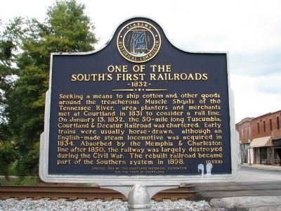
| 101 ► Alabama, Lawrence County, Courtland — Early Roads / One of the South's First Railroads 1832 — |
| On College St.. | |||
| 102 ► Alabama, Lee County, Auburn — The Crescent — |
| On Mitcham Avenue at North Gay Street, on the right when traveling east on Mitcham Avenue. | |||
| 103 ► Alabama, Lee County, Auburn — The Auburn Guards Reviewed by Jefferson Davis — |
| On Mitcham Avenue at North Gay Street, on the right when traveling west on Mitcham Avenue. | |||
| 104 ► Alabama, Lee County, Opelika — Opelika A Railroad Town/Opelika An Industrial City — |
| On South Railroad Avenue west of South 8th Street, on the left when traveling west. | |||
| 105 ► Alabama, Lee County, Opelika — Railroad Avenue Historic District — Opelika, Alabama — |
| On South Railroad Avenue at South 9th Street, on the right when traveling north on South Railroad Avenue. | |||
| 106 ► Alabama, Lee County, Opelika — Rosseau's Raid to East Alabama — |
| On South 8th Street at South Railroad Avenue, on the right when traveling south on South 8th Street. | |||
| 107 ► Alabama, Lee County, Opelika — South Railroad Avenue — |
| On South 9th Street at South Railroad Avenue, on the right when traveling south on South 9th Street. | |||
| 108 ► Alabama, Limestone County, Athens — Faces of Market Street — |
| On Market Street east of North Marion Street, on the right when traveling west. | |||
| 109 ► Alabama, Limestone County, Elkmont — Battle of Sulphur Creek Trestle — |
| On Elkmont Road/North Jefferson Street (Alabama Route 127) 1.2 miles south of Morris Road, on the right when traveling south. | |||
| 110 ► Alabama, Limestone County, Elkmont — Commerce — |
| On Upper Fort Hampton Road (County Route 49) east of Railroad Street, on the left when traveling east. | |||
| 111 ► Alabama, Limestone County, Elkmont — Elkmont, Alabama / Tenn. & Ala. Central Railroad — |
| On County Road 49 east of Railroad Street, on the left when traveling east. | |||
| 112 ► Alabama, Limestone County, Elkmont — Sulphur Creek Trestle, 1864 — |
| On Upper Fort Hampton Road (County Road 49) east of Railroad Street, on the right when traveling east. | |||
| 113 ► Alabama, Limestone County, Mooresville — Mooresville Alabama — Est. 1818 — |
| Near Lauderdale Street west of East Street (County Road 71), on the right when traveling west. | |||
| 114 ► Alabama, Macon County, Fort Davis — Fort Davis Railroad Depot / Fort Davis Community — Macon County — |
| On U.S. 29 north of County Road 2, on the right when traveling north. | |||
| 115 ► Alabama, Macon County, Tuskegee — Battle of Chehaw Station — |
| On Alabama Route 199 at Old Chehaw Road, on the right when traveling north on State Route 199. | |||
| 116 ► Alabama, Madison County, Gurley — Town of Gurley — |
| On Lee Highway/John T Reid Parkway (U.S. 72) at Gurley Pike, on the right when traveling west on Lee Highway/John T Reid Parkway. | |||
| 117 ► Alabama, Madison County, Huntsville — C.B. "Bill" Miller Bridge — |
| On Heart of Huntsville Drive SW south of Constellation Drive, on the right when traveling south. | |||
| 118 ► Alabama, Madison County, Huntsville — Historic Viduta / Hotel Monte Sano — |
| On Monte Sano Boulevard Southeast at Old Chimney Road Southeast, on the left when traveling north on Monte Sano Boulevard Southeast. | |||
| 119 ► Alabama, Madison County, Huntsville — Hotel Monte Sano — “Monte Sano” – Spanish for “Mountain of Health” — |
| On Old Chimney Road Southeast, on the right when traveling south. | |||
| 120 ► Alabama, Madison County, Huntsville — Monte Sano Railway — |
| On Nolen Avenue Southeast east of Chickasaw Drive Southeast, on the left when traveling east. | |||
| 121 ► Alabama, Madison County, Huntsville — Passenger Depot — Huntsville, Alabama — Built 1860 — |
| On Church Street NW, on the right when traveling north. | |||
| 122 ► Alabama, Madison County, Madison — City of Madison |
| On Church Street near Front Street. Reported missing. | |||
| 123 ► Alabama, Marengo County, Linden — History of Linden, Alabama — |
| On South Main Street (U.S. 43) at East 8th Avenue, on the right when traveling north on South Main Street. | |||
| 124 ► Alabama, Marion County, Glen Allen — Town of Glen Allen, Alabama — |
| On Alabama Route 129 just north of Twin Street North, on the right when traveling north. | |||
| 125 ► Alabama, Marion County, Guin — City of Guin, Alabama: The Early Years / The Storms of 1974 — |
| On 11th Avenue (U.S. 43) at U.S. 278, on the right when traveling west on 11th Avenue. | |||
| 126 ► Alabama, Mobile County, Mobile — Mobile's Last Mule Car — |
| On South Claiborne Street, on the right when traveling south. | |||
| 127 ► Alabama, Mobile County, Mobile — The Hunley — |
| On North Water Street, 0.1 miles north of St Anthony Street, on the right when traveling north. | |||
| 128 ► Alabama, Mobile County, Mobile — 34 — The Slave Market — |
| On North Royal Street, 0.1 miles St Anthony Street, on the right when traveling south. | |||
| 129 ► Alabama, Mobile County, Mt. Vernon — 3 — Mount Vernon Historical Museum and Train Depot — Mount Vernon History Trail — |
| On Old Military Road (Alabama Route 96) at State Street, on the right when traveling east on Old Military Road. | |||
| 130 ► Alabama, Mobile County, Whistler — St. Bridget's Catholic Church — |
| On West Main Street west of Mount Sinai Avenue, on the left when traveling west. | |||
| 131 ► Alabama, Montgomery County, Montgomery — Birth of Montgomery Bus Boycott — Boycott planned & publicized here at ASU's Councill Hall — |
| On Tullibody Drive at University Drive North, on the right when traveling north on Tullibody Drive. | |||
| 132 ► Alabama, Montgomery County, Montgomery — Pickett Springs / “The Best Public Resort” — |
| On County Road 2120, 0.3 miles east of Lower Wetumpka Road, on the left when traveling east. | |||
| 133 ► Alabama, Montgomery County, Montgomery — Rosa Louise Parks — She sat down - So we can stand up — February 4, 1913 - October 24, 2005 — |
| On South Jackson Street at University Drive North, on the right when traveling north on South Jackson Street. | |||
| 134 ► Alabama, Montgomery County, Montgomery — Rosa Parks and the Montgomery Bus Boycott — |
| On Montgomery Street at Molton Street, on the right when traveling south on Montgomery Street. | |||
| 135 ► Alabama, Montgomery County, Montgomery — Smith - Joseph - Stratton House — |
| On Alabama Street east of South McDonough Street, on the right when traveling east. | |||
| 136 ► Alabama, Montgomery County, Montgomery — The Domestic Slave Trade / Slave Transportation to Montgomery — |
| On Commerce Street at Water Street, on the left when traveling north on Commerce Street. | |||
| 137 ► Alabama, Montgomery County, Montgomery — The Lightning Route / Central Bank Building |
| On Court Square at Dexter Avenue, on the right on Court Square. Reported missing. | |||
| 138 ► Alabama, Montgomery County, Montgomery — Train Shed 1897 — National Historic Landmark — |
| Near Water Street. | |||
| 139 ► Alabama, Montgomery County, Montgomery — Transportation and Commerce — |
| On Water Street. | |||
| 140 ► Alabama, Montgomery County, Montgomery — Tribute to Montgomery's "Foot Soldiers" — |
| On Montgomery Street at Molton Street, on the right when traveling south on Montgomery Street. | |||
| 141 ► Alabama, Montgomery County, Montgomery — Union Station & Riverfront Park / Lower Commerce Street |
| On Commerce Street, in the median. Reported missing. | |||
| 142 ► Alabama, Montgomery County, Montgomery, Forest Park — Remount Depot / Keyton Station — |
| On East Fifth Street at Jean Street, on the right when traveling east on East Fifth Street. | |||
| 143 ► Alabama, Morgan County, Decatur — Cherokee Trail Of Tears — |
| Near Oak Street north of Market Street. | |||
| 144 ► Alabama, Morgan County, Decatur — First Railroad — West of Allegheny Mountains - Tuscumbia, Courtland & Decatur RR. — |
| On Railroad Street Northwest east of Vine Street, on the left when traveling east. | |||
| 145 ► Alabama, Morgan County, Decatur — Historic Downtown/Founders Park — |
| On Bank Street NE at Church Street NE on Bank Street NE. | |||
| 146 ► Alabama, Morgan County, Decatur — Old Decatur Historic District / Historic Depot — |
| On Railroad Street NW at Vine Street NW, on the left when traveling north on Railroad Street NW. | |||
| 147 ► Alabama, Morgan County, Decatur — 7 — Two Bridges Across The Tennessee River — “A Hard Nut To Crack” — The Battle For Decatur — |
| On Wilson Street Northwest (U.S. 72) at Raiload Street, on the right when traveling west on Wilson Street Northwest. | |||
| 148 ► Alabama, Pickens County, Aliceville — Alabama, Tennessee & Northern Railroad Depot — |
| On Memorial Parkway (Alabama Route 14) at Broad Street, on the right when traveling east on Memorial Parkway. | |||
| 149 ► Alabama, Pickens County, Carrollton — Carrollton Short Line Railroad — |
| On Tuscaloosa Street (Alabama Route 86) at AT&N Railroad Street, on the left when traveling west on Tuscaloosa Street. | |||
| 150 ► Alabama, Pickens County, Gordo — History of Gordo, Alabama — |
| On North Main Street (Alabama Route 159) at 2nd Avenue Northwest, on the right when traveling north on North Main Street. | |||
| 151 ► Alabama, Shelby County, Helena — Helena Freight House & Depot — |
| On Lake Davidson Lane at Helena Road (Alabama Road 261), on the right when traveling west on Lake Davidson Lane. | |||
| 152 ► Alabama, Shelby County, Helena — Helena, Alabama — |
| On Helena Road (State Road 261) at 1st Avenue East, on the right when traveling north on Helena Road. | |||
| 153 ► Alabama, Shelby County, Shelby — Calera & Shelby Railroad — The Former "Alabama Mineral Railroad", A Division of the L&N Railroad. — |
| Near School Road south of County Route 308, on the right when traveling south. | |||
| 154 ► Alabama, Shelby County, Wilton — Town of Wilton — Incorporated April 30, 1918 — |
| On Depot Street at Church Street, on the right when traveling west on Depot Street. | |||
| 155 ► Alabama, St. Clair County, Cropwell — Cropwell History — |
| On Mays Drive at Hardwick Road, on the right when traveling north on Mays Drive. | |||
| 156 ► Alabama, Sumter County, York — History of York / The Coleman Center — |
| On Avenue A at College Street, on the right when traveling east on Avenue A. | |||
| 157 ► Alabama, Talladega County, Lincoln — Lincoln, Alabama — |
| On County Road 433 north of 1st Avenue, on the right when traveling north. | |||
| 158 ► Alabama, Talladega County, Sylacauga — Sylacauga Historic Commercial District — Talladega County — |
| On North Broadway Avenue (Alabama Route 21) at East 1st Street, on the right when traveling north on North Broadway Avenue. | |||
| 159 ► Alabama, Tallapoosa County, Alexander City — Court Square — |
| On Church Street at Main Street, on the right when traveling west on Church Street. | |||
| 160 ► Alabama, Tallapoosa County, Alexander City — The Savannah And Memphis Railroad 1874 — |
| On Broad Street at Main Street, on the right when traveling east on Broad Street. | |||
| 161 ► Alabama, Tallapoosa County, Alexander City — Youngsville — |
| On Washington Street west of South Central Avenue, on the right when traveling west. | |||
| 162 ► Alabama, Tuscaloosa County, McCalla — Pipe DL & CO 1889 — |
| Near Confederate Parkway at Tannehill Road. | |||
| 163 ► Alabama, Tuscaloosa County, Tuscaloosa — Gabriel Moore — Governor 1829 - 1831 — |
| On 6th Street west of 28th Avenue, on the right. | |||
| 164 ► Alabama, Tuscaloosa County, Tuscaloosa — The M & O Railroad Trestle — |
| On 2nd Street at 28th Avenue, on the right when traveling west on 2nd Street. | |||
| 165 ► Alabama, Wilcox County, Pine Hill — Pine Hill, Alabama — Incorporated December 2, 1895 — |
| On Broad Street (State Highway 5) west of Oak Grove Street, on the right when traveling south. | |||
| 166 ► Alabama, Winston County, Haleyville — City of Haleyville, Alabama — |
| On 20th Street at 10th Avenue, on the right when traveling east on 20th Street. | |||
| 167 ► Alaska, Denali Borough, Denali National Park — Tunnels Lost to Time — |
| On Morning Loop Trail. | |||
| 168 ► Alaska, Fairbanks North Star Borough, Fairbanks — Harding Car — |
| On Airport Way. | |||
| 169 ► Alaska, Skagway — Skagway and White Pass — |
| Near 2nd Street. | |||
| 170 ► Alaska, Valdez-Cordova Census Area, Chitina — Railway to Riches — |
| On McCarthy Road (at milepost 29), on the left when traveling west. | |||
| 171 ► Alaska, Valdez-Cordova Census Area, Chitina — Wooden Wonder — |
| On McCarthy Road (at milepost 29), on the left when traveling west. | |||
| 172 ► Alaska, Valdez-Cordova Census Area, Valdez — Old Railroad Tunnel — |
| On Richardson Highway (Alaska Route 4 at milepost 15). | |||
| 173 ► Alaska, Yukon-Koyukuk Census Area, Nenana — First Presidential Visit — |
| On Front Street east of George Parks Highway (Alaska Route 3), on the right when traveling east. | |||
| 174 ► Alaska, Yukon-Koyukuk Census Area, Nenana — Golden Spike — |
| 175 ► Arizona, Apache County, Adamana — Santa Fe Railroad — Petrified Forest National Park — National Park Service, U.S. Department of the Interior — |
| Near Petrified Forest Road, on the right when traveling north. | |||
| 176 ► Arizona, Cochise County, Bowie — Parke Camp Site — |
| Near Fort Bowie Trail, 0.4 miles south of Apache Pass Road. | |||
| 177 ► Arizona, Cochise County, Douglas — Douglas Police Headquarters — Douglas, Arizona — |
| Near East 14th Street at 14th Street & Pan American Ave.. | |||
| 178 ► Arizona, Cochise County, Douglas — Douglas R.R. YMCA — |
| On Pan American Avenue (U.S. 191) at 10th Street, on the right when traveling south on Pan American Avenue. | |||
| 179 ► Arizona, Cochise County, Tombstone — 38 — Southern Pacific Train Depot — 1903 — |
| Near South 4th Street, on the left when traveling south. | |||
| 180 ► Arizona, Cochise County, Willcox — Railroad Avenue — |
| On East Maley Street (Arizona Route 186) at South Railroad Avenue, on the left when traveling east on East Maley Street. | |||
| 181 ► Arizona, Cochise County, Willcox — The Southern Pacific Railroad Depot, 1880 — |
| On South Railroad Avenue, on the left when traveling south. | |||
| 182 ► Arizona, Coconino County, Flagstaff — "The Gandy Dancer" — |
| On Route 66 at South San Francisco Street, on the right when traveling east on Route 66. | |||
| 183 ► Arizona, Coconino County, Flagstaff — Flagstaff's Founding — |
| 184 ► Arizona, Coconino County, Flagstaff — Railroad Depot — 1926 — |
| Near East Route 66. | |||
| 185 ► Arizona, Coconino County, Flagstaff — Transcontinental Railroad Centennial — |
| Near East Route 66. | |||
| 186 ► Arizona, Coconino County, Flagstaff — Two Spots — Arizona Lumber and Timber Company Steam Engine — |
| On East Santa Fe Avenue (U.S. 89), on the right when traveling east. | |||
| 187 ► Arizona, Coconino County, Grand Canyon National Park — A Trail, a Camp, and a "Hermit" — |
| Near Hermit Road at West Rim Trail. | |||
| 188 ► Arizona, Coconino County, Grand Canyon National Park — Grand Canyon Depot — |
| Near Village Loop Drive. | |||
| 189 ► Arizona, Coconino County, Grand Canyon National Park — Hermit Camp — Grand Canyon — National Park Service, U.S. Department of the Interior — |
| Near Hermit Road at West Rim Trail. | |||
| 190 ► Arizona, Coconino County, Grand Canyon National Park — Santa Fe Depot — |
| 191 ► Arizona, Coconino County, North Rim — Grand Canyon Lodge, 1928-1932 — Grand Canyon National Park — |
| Near Grand Canyon Highway (Arizona Route 67) 43 miles south of U.S. 89A, on the left when traveling south. | |||
| 192 ► Arizona, Coconino County, North Rim — Grand Canyon Lodge, A Legacy Rebuilt — Grand Canyon National Park — |
| Near Grand Canyon Highway (Arizona Route 67) 43 miles south of U.S. 89A, on the left when traveling south. | |||
| 193 ► Arizona, Coconino County, Williams — Caboose Jake 017 — |
| Near Fray Marcus Drive west of North Grand Canyon Boulevard. | |||
| 194 ► Arizona, Coconino County, Williams — Santa Fe Railway Freight Depot — |
| On West Bill Williams Avenue at North Grand Canyon Boulevard, on the right when traveling west on West Bill Williams Avenue. | |||
| 195 ► Arizona, Coconino County, Williams — Williams, Arizona — |
| On Grand Canyon Avenue at North Pine Street, on the right when traveling east on Grand Canyon Avenue. | |||
| 196 ► Arizona, Greenlee County, Clifton — Town of Clifton — |
| On North Coronado Boulevard (U.S. 191 at milepost 163.3), on the right when traveling north. | |||
| 197 ► Arizona, Maricopa County, Glendale — William J. Murphy — Founder of Glendale — |
| On North 58th Avenue at West Glendale Avenue, on the right when traveling south on North 58th Avenue. | |||
| 198 ► Arizona, Maricopa County, Phoenix, Central City — Arizona Copper Company's Locomotive #2 — |
| On West Washington Street, 0.1 miles west of 15th Avenue, on the right when traveling west. | |||
| 199 ► Arizona, Maricopa County, Phoenix, Central City — Chambers Transfer & Storage Company Building — |
| On West Jackson Street at 4th Avenue when traveling south on West Jackson Street. | |||
| 200 ► Arizona, Maricopa County, Phoenix, Central City — Santa Fe Freight Depot — |
| On West Jackson Street at 5th Avenue when traveling south on West Jackson Street. | |||
8836 entries matched your criteria. Entries 101 through 200 are listed above. ⊲ Previous 100 — Next 100 ⊳