On Northwest 140th Street just south of Northwest 148th Place, on the right when traveling north.
In 1822, John J. Triggs was sent as a Methodist missionary to a new mission called Alapaha. This mission extended from south Georgia into parts of north Florida, extending east and west of the Suwanee River. Four missions were established in this . . . — — Map (db m239328) HM
On Main Street at NW 150th Avenue, on the right when traveling south on Main Street.
City of Alachua Downtown Historic District has been placed on the National Register of Historic Places in 2000 by the United States Department of the Interior — — Map (db m239993) HM
On Southwest 175th Terrace at Southwest 174th Street, on the right when traveling east on Southwest 175th Terrace.
Side 1
The Bethlehem Methodist Episcopal Church and Cemetery of Archer were established in 1873. The Rev. Major Reddick donated the land, which was part of a parcel awarded to him through the 1862 Homestead Act. Church trustees were Romeo . . . — — Map (db m236679) HM
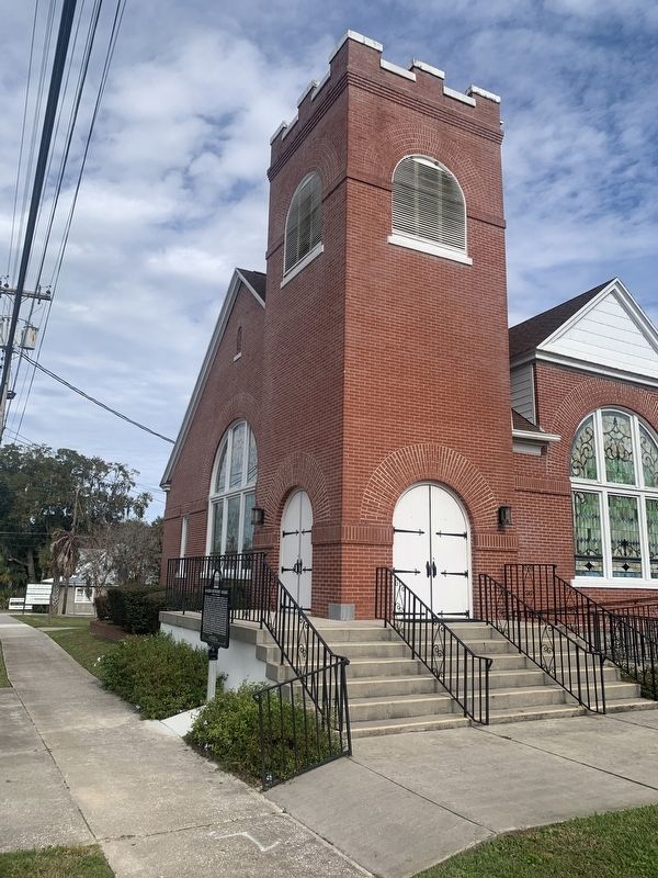
On Southwest 137th Avenue (West Church Street) at Southwest 170th Street (Gibson Avenue) (Florida Route 241), on the right when traveling west on Southwest 137th Avenue (West Church Street).
Bethlehem Presbyterian Church was first organized in 1866 at Wacahoota, a farming community southeast of Archer. The early members were pioneer families from South Carolina. Their first pastor, the Rev. William McCormick, founded other pioneer . . . — — Map (db m150976) HM
On Southwest 170th Street (County Route 241) at Southwest 83rd Avenue, on the right when traveling north on Southwest 170th Street.
Side 1
African American families living in rural unincorporated Archer used the burial ground that would later become St. Peter Cemetery since before the end of the U.S. period of legalized slavery. Following the abolition of slavery, freed . . . — — Map (db m209527) HM
On Southwest 75th Terrace, 0.1 miles south of Archer Road (State Road 24), on the left when traveling south.
In 1857, a group of Sea Island cotton planters from South Carolina who settled near here called an organizational meeting to establish Kanapaha Presbyterian Church. The Reverend William J. McCormick (1821-1883) was recruited from South Carolina to . . . — — Map (db m111045) HM
On NW 2nd Street near NW 7th Avenue, on the left when traveling north.
Mount Pleasant Methodist Episcopal Church was founded on July 16, 1867, with the Reverend Isaac Davis serving as the first pastor. The Board of Trustees of the oldest black congregation in Gainesville purchased the lot on which the present church . . . — — Map (db m55606) HM
On Northwest 5th Avenue at Northwest 4th Street, on the right when traveling east on Northwest 5th Avenue.
The congregation of the Mt. Carmel Baptist Church first met on May 4, 1896. The church’s original members worshipped in the St. Paul CME Church, and together the congregations bought a parcel of land in 1900 to build a new church. Its construction . . . — — Map (db m110982) HM
On SW 5th Street at SW 8th Avenue, on the right when traveling south on SW 5th Street.
Shady Grove Primitive Baptist Church is a landmark in Porters Quarters, one of Gainesville’s oldest and most historic African-American neighborhoods. Dr. Watson Porter, a Canadian physician, established Porters addition to Gainesville in 1884 and . . . — — Map (db m150690) HM
On Pearl Street at Hampton Street, on the right when traveling east on Pearl Street.
The Melrose United Methodist Church was organized in 1868 as the Melrose Methodist Episcopal Church, South. This church building, the first located within the original 1877 plat of Melrose, was constructed out of heart pine by the congregation in . . . — — Map (db m120212) HM
On Northwest 166th Street at Northwest 20th Avenue, on the left when traveling north on Northwest 166th Street.
Side 1
On August 19, 1916, African Americans living in the Jonesville and Newberry communities were lynched. At 2:00 a.m., Constable George Wynne, Dr. L.G. Harris, and G.H. Blount drove to Boisey Long's home in Jonesville to serve a warrant and . . . — — Map (db m135956) HM
On Old Bellamy Road, 0.2 miles west of Northwest 173rd Road Street,, on the left when traveling west.
SPRING HILL UNITED METHODIST CHURCH
In 1860, after the era of circuit rider preachers, the local Methodists built a church. Five men, including Simeon Dell and Fernando Underwood, bought five acres on the Bellamy Road for $50. Though the price . . . — — Map (db m197956) HM
On Old Bellamy Road, 0.2 miles west of Northwest 173rd Road Street, on the left when traveling west.
Springhill Methodist Church
Organized-1860,
On the Bellamy Road
Present building erected,
1915
Educational annex a part of
Bland Church
1956
Traxler, Fla.
This community was named
Traxler in the late 1880's
when . . . — — Map (db m172727) HM
On Beulah Avenue, 0.1 miles south of Minneola Street, on the right when traveling south.
The Callaway School House was built in 1911 (two years prior to the creation of Bay County in 1913) on the SW corner of Beulah Avenue and Letohattchee Street. Callaway had been surveyed and platted in 1908 by Pitt Milner Callaway for whom the . . . — — Map (db m73287) HM
On Grace Avenue at West 10th Street, on the left when traveling north on Grace Avenue.
This house at 941 Grace Avenue was built by Maude and Earle Thompson in 1924. The couple lived here with their three children who retained possession of the house until 2008. The Thompson family were among the first citizens of Panama City and . . . — — Map (db m245298) HM
On Chesnut Avenue at West 11th Street, on the left when traveling south on Chesnut Avenue.
The St. Andrew Methodist Episcopal Church was organized in St. Andrews in 1886 and construction of this sanctuary was completed in 1887. In 1939, $600.00 was borrowed to add the front foyer, which covered the glass panes above the door. To alleviate . . . — — Map (db m245302) HM
On Beck Avenue (Florida Route 30) at West 14th Street, on the right when traveling south on Beck Avenue.
The St. Andrews Presbyterian Church was organized September 13, 1886 at 4:00 PM in the home of Mr. Hiram M. Mapes. The church roll was comprised of 16 members. For little more than a year, the small band of Presbyterians met at the homes of members . . . — — Map (db m245511) HM
On Elm Avenue at East 7th Street, on the right when traveling north on Elm Avenue.
New Bethel Missionary Baptist Church was founded by Rev. Walter and Sister Mary Jackson on December 10, 1908. The original name for the church was Missionary Baptist Church of Washington County in the State of Florida. Millville was in Washington . . . — — Map (db m245471) HM
On Indian River Drive (County Road 515) 0.1 miles south of Briarwood Lane, on the left when traveling north.
Known as City Point, this area was settled shortly after the Civil War by Confederate veterans, citrus grove workers, northern winter residents, and consumptives seeking a healthy climate. By early 1885, a board of trustees was formed consisting of . . . — — Map (db m203571) HM
On Derby Street at Brevard Avenue, on the left when traveling west on Derby Street.
Dedicated on July 13, 1924, this structure was built by the Seventh Day Adventist Church, and was heralded by The Cocoa Tribune as “an honor to the City.” In 1955 it was sold to the Church of Christ, Scientist. In 1964 it was sold to the . . . — — Map (db m125640) HM
On Church Street at Riverside Drive, on the left when traveling east on Church Street.
On June 2, 1878, the Right Reverend John Freeman Young, Bishop of Florida, and Dr. William H. Carter of Holy Cross Church of Sanford, Florida, held the first meeting of St. Mark’s Episcopal Church at a nearby Rockledge residence. The mission was . . . — — Map (db m70299) HM
On Old Dixie Highway at Briarwood Lane, on the left when traveling south on Old Dixie Highway.
Founded by Tom Johnson Cockshutt in 1869, this was the first organized Protestant Church on the East Coast of Florida between New Smyrna and Key West. Tom donated land for a cemetery and built a small log structure located on what is now the . . . — — Map (db m101179) HM
On Highland Avenue, on the left when traveling south.
On October 10, 1910, the original church, known as the Second Advent Church of Eau Gallie, was formally organized by the Rev. H. V. Skipper. Early meetings were held in neighborhood homes and in the Riverside Hotel, owned by John R. Mathers. Mathers . . . — — Map (db m49380) HM
On Lipscomb Street just south of Brothers Avenue, on the right when traveling south.
Allen Chapel A.M.E. Church was organized in the 19th century, in the dining room of Wright and Mary Brothers home on Crane Creek, facing the northwest of Lipscomb street. The house is still standing. The organizers, in addition to the Brothers, . . . — — Map (db m242675) HM
On Peachtree Street at West Strawbridge Avenue, on the left when traveling north on Peachtree Street.
First organized in 1884, Holy Trinity Episcopal Church was erected in 1886 on land donated by Lucy Boardman, who also provided plans for the building. Founding members of the congregation included the Goode, Campbell, Miller, Ely, Ellis and Grubb . . . — — Map (db m52927) HM
On West Strawbridge Avenue at Greenway Drive, on the right when traveling west on West Strawbridge Avenue. Reported missing.
This church was built on a 93-acre site purchased from Wright Brothers. The land, located on the south bank of Crane Creek, and the church were the gift of Lucy Boardman, a winter visitor from New Haven Connecticut.
G.J. Gingras of Cocoa . . . — — Map (db m223605) HM
This building was erected in 1913 and contained a billiard parlor and restaurant on the ground floor, and the Midway Hotel upstairs. The Melbourne Times moved from its Front Street location to this building almost as soon as it was finished, and . . . — — Map (db m49939) HM
St. John's Episcopal Church parish was founded in 1890, but the church was not built until 1897. The first services were held Feb. 20, 1898. The design of the church is copied from one in Como, Canada, where the Hodgson family formerly lived. The . . . — — Map (db m49137) HM
A Methodist circuit rider, with the aid of early settlers in Eau Gallie, erected a small mission cut out of logs on the north bank of Horse Creek. It was finished with a puncheon floor. Travel to the services was by boat. From 1888 until 1900 the . . . — — Map (db m49237) HM
On Strawbridge Avenue (U.S. 192) at U.S. 1, on the right when traveling west on Strawbridge Avenue.
The First Congregational Church of Melbourne had its beginnings in 1887 when Edward Branch and his wife Abbie began to hold regular Bible study and worship meetings. In December 1887, five men and seven women signed a covenant that was the first . . . — — Map (db m66831) HM
James Wadsworth Rossetter, Sr., came to Eau Gallie in 1902. He purchased this property in 1903. The house was built before the War Between the States and is on the former site of the Houston family's slave quarters. One member of that pioneer . . . — — Map (db m48975) HM
On Ocean Avenue, on the right when traveling west.
This historic Chapel, the oldest Church on the Beaches, has been the center of community religious life since it was built in 1892 on land donated in 1890 by Mr. And Mrs. Henry Whiting.
At a cost of $200 and a donation for interior finishing, . . . — — Map (db m52929) HM
On North Tropical Trail at Northgrove Drive, on the left when traveling north on North Tropical Trail.
Established in 1892, the Bethel A.M.E. Church of Merritt Island was the first African Methodist Episcopal church on North Tropical Trail, located on land James R. Ragan originally acquired through the Homestead Act in 1895. The wooden church sat on . . . — — Map (db m101067) HM
On Bevis Road, 0.3 miles south of Lucas Road, on the right when traveling north.
Dennis Sawyer Memorial Park was established in 1956 when R.V. and Hazel Woods deeded three acres of land for use as an African American cemetery. It was originally managed by Greater Mount Olive AME Church, but years later, the cemetery deteriorated . . . — — Map (db m192604) HM
On South Tropical Trail (County Road 3) at Crooked Mile Road, on the right when traveling south on South Tropical Trail.
Georgianna United Methodist Church was built in the community of Georgiana on Merritt's Island in 1886. The ringing of the church bell still marks the beginning of worship as it has for many decades. Franklin C. Allen, Jr., a local homesteader, . . . — — Map (db m102267) HM
On South Tropical Trail (County Road 3) at Old Settlement Road, on the right when traveling south on South Tropical Trail.
Provost Hall was originally constructed in 1910 as the Georgiana Club house on land provided by Charles D. Provost and his wife Gertrude Breese Provost. Until their grandchildren, Charles D. Provost and his sister, Mary Virginia Provost Katz, gave . . . — — Map (db m94407) HM
On North Tropical Trail at Church Road, on the left when traveling north on North Tropical Trail.
St. Luke's Episcopal Church of Courtenay was formed by the Porcher, LaRoche, Sams and other families that settled on north Merritt Island after leaving the Charleston, South Carolina area in 1875 due to the loss of their homes and plantations during . . . — — Map (db m101022) HM
On North Tropical Trail, 0.1 miles south of Sawyer Avenue, on the right when traveling north.
Edwin Dennis Sawyer (1874-1964) was born in the Bahamas, the second child of freed slave Alfred Sawyer. From age 18-25, Dennis worked on a ship and then in Ft. Pierce as a fisherman. In 1898, after moving to Cocoa, he married Rebecca Dallas. The . . . — — Map (db m192603) HM
Near South Sykes Creek Parkway at Fortenberry Road.
Humanity In War
This monument honors all military members of the Chaplain Corps. Remember those who serve our troops be they Christian, Jewish, Muslim, Hindu, Buddhist or any other religion.
The first chaplain was commissioned on . . . — — Map (db m164838) WM
On Harry T. Moore Avenue at Ricard Street, on the right when traveling south on Harry T. Moore Avenue.
In 1894, after organizing a congregation, St. James Colored Missionary Baptist Church acquired land in Mims, and with Rev. G. Brewer as pastor, built the first wooden church on this site in 1904 under the guidance of Rev. J.S. Gilbert. Many of North . . . — — Map (db m101402) HM
On Old Dixie Highway just south of Diamond Road, on the left when traveling south.
Established in 1869, this is the oldest cemetery on Florida's lower East Coast. The oldest portion is located in the front center section, evidenced by the southeasterly positioning of the tombstones. Tom Johnson Cockshutt (1841-1917), who arrived . . . — — Map (db m101404) HM
On Old Dixie Highway at Diamond Road, on the left when traveling south on Old Dixie Highway.
In the early 1900s, a two acre parcel of land north of LaGrange Community Church and Cemetery was given to the Mims colored community for a cemetery. Earliest marked graves are dated 1903; many are unmarked. In the 1800s both blacks and whites . . . — — Map (db m101403) HM
On Northeast Miller Street at Pollack Avenue Northeast, on the right when traveling south on Northeast Miller Street.
In the early twentieth century, the North Dakota-based Florida Indian River Catholic Colony corporation advertised it was starting a Catholic community in central Florida. By 1914, the land company helped settle nearly 100 midwestern families, . . . — — Map (db m175719) HM
Near Cassia Blvd. just east of South Patrick Drive (Local Road 513), on the right when traveling east.
A strong Christian man who cared for the needs of others more than his own. Founder and first Mayor of Satellite Beach. A man who invested his time, talent and resources to help others. Through 16 years of dedicated service as Mayor, from 1957 to . . . — — Map (db m48978) HM
On South Palm Avenue at Pine Street, on the right when traveling south on South Palm Avenue.
In 1887, construction of a church was begun on land donated to the Titusville Episcopal mission by Mary Titus, wife of the town's founder, and J. Dunlin Perkinson, lay reader of the mission. The name of the church was changed from St. John's to St. . . . — — Map (db m101181) HM
On South Federal Highway (U.S. 1) south of Southeast 1st Street, on the right when traveling north.
Mount Sinai United Methodist Church 1113 S. Federal Highway (originally called the Dania Methodist Episcopal Church) was organized in January 1906.
The first services were held in the town schoolhouse under the organization influence of Mr. & . . . — — Map (db m146547) HM
On Northwest 5th Avenue at Northwest 2nd Street, on the right when traveling south on Northwest 5th Avenue.
The Saint Ruth Missionary Baptist Church was organized in 1908 by the late Charlie Chambers and a few other faithful souls in Modello, Florida. The Church was named Saint Ruth in honor of Brother Charie Chamber's daughter, Ruth. The first place of . . . — — Map (db m146518) HM
The settlement of Deerfield was founded on the southeast coast of Florida with the coming of Henry Flagler’s Florida East Coast Railroad in 1896. In 1902, two Methodist missionaries began holding religious services for the community. These early . . . — — Map (db m100392) HM
On Northwest 1st Avenue at Northwest 9th Street, on the left when traveling south on Northwest 1st Avenue .
The Greater Ebenezer Missionary Baptist Church was established in 1909 by Sister Lougenia Johnson and Sister Missouri Wilson conducting Sunday School under a rubber tree. In 1910 Rev. A.T. Taylor, his wife, and Sister Lula Mack joined the group and . . . — — Map (db m100359) HM
On Northwest 6th Avenue at Northwest 9th Street, on the right when traveling south on Northwest 6th Avenue .
"To God Be The Glory For All Of The Great Things He Has Done"
In 1902 a mustard seed was planted in the community, and with God's blessing a group known as the "Pioneers" established the first church, which blossomed the dream into a reality. . . . — — Map (db m100395) HM
On Northwest 1st Avenue at Northwest 7th Street, on the left when traveling north on Northwest 1st Avenue .
St. Anne's Episcopal Church was established in 1914 by Melbourne Knowles, Ansel Saunders and A.L. Wilkins, all hailing from the Islands of the Bahamas. The first church services were held in a wooden building located on the corner of what in now . . . — — Map (db m100397) HM
On North Main Street (Florida Route 71) just south of Chipola Street (County Route 274), on the right when traveling north.
The Richards family had a long history of building churches in Northwest Florida. Daniel Thomas Richards (1825-1879), survivor of an Indian attack on Fort Richards/Fort Place, and son of Rev. John G. Richards of Wewahitchka, built Moss Hill . . . — — Map (db m177686) HM
On Chipola Street (County Route 274) 1.3 miles west of North Main Street (Florida Route 71), on the right when traveling west. Reported missing.
On this site are the remains of early area settlers, the Richards family. As a prominent Virginia Colonial family, George Richards (1727-1818) was with Washington at Braddocks Defeat (1755), and with his sons in the Revolutionary War (1776). The . . . — — Map (db m186749) HM
On Seneca Avenue at Parmely Street, on the right when traveling north on Seneca Avenue.
A congregation has met at Trinity United Methodist Church continuously since 1873. The first church organized in today's Charlotte County, its members have been an integral part of our history. Joel and Jesse Knight, James McKay and Jacob Summerlin . . . — — Map (db m101019) HM
On North Florida Avenue (U.S. 41) at East Parsons Point Road, on the right when traveling north on North Florida Avenue.
(side 1)
Church of the Nazarene Hernando
Hernando, named for Spanish explorer Hernando de Soto, was founded in 1881 by the Croft and Van Ness families. Beside the Tsala Apopka lakes their citrus groves thrived. Development followed . . . — — Map (db m112147) HM
On Dr. Martin Luther King Jr. Avenue at East Dampier Street, on the right when traveling north on Dr. Martin Luther King Jr. Avenue.
This church was first organized September 29, 1894 by Rev. A.L. Dutch, Deacon Arthur Bell, and the entire membership of Shialo Baptist Church from Stage Pond, Florida. Over the last 116 years, this congregation has been led by 16 different . . . — — Map (db m72781) HM
On Old Church Road, 0.2 miles north of Augusta Drive, on the left when traveling north.
Hibernia Plantation was founded in 1790 by Irish immigrant George Fleming on a 1,000-acre grant from the Governor of Spanish East Florida. George died in 1821 and his son Lewis inherited Hibernia. Lewis had three children by his first wife. After . . . — — Map (db m128318) HM
On Idlewild Avenue (Florida Route 16) 0.2 miles west of Sunset Avenue, on the right when traveling west.
Hickory Grove Baptist Church was organized in 1863, and the church’s congregation first worshiped here in one of the earliest buildings constructed in Clay County. The church was named for a grove of hickory trees that grew here. The original . . . — — Map (db m102455) HM
On Sharron Road at Sweet Moody Road, on the left when traveling east on Sharron Road.
Organized by the Rev. James Hickey. Charter Members: Robert and Adeline Hogarth, Mr. and Mrs. J.M. Tolar, Mrs. Sarah Smith, Mrs. Mahoney, Mr. and Mrs. R.B. Sullivant, and Mrs. Celia Weeks. Property for church given by T.H. and C.B. Hayden. Cemetery . . . — — Map (db m110522) HM
On Main Street at Wharf Street, on the right when traveling east on Main Street.
Middleburg developed in the early 1800s as a transportation center linking the St. Johns River with the peninsular interior. Originally settled in the 1820s as Clark´s Ferry, a crossing on Black Creek, it became a major military entrepot during the . . . — — Map (db m102459) HM
On Main Street at Butler Avenue, on the right when traveling east on Main Street.
Founded on or before July 27, 1828 by Isaac Boring, a Methodist Circuit Riding Preacher. First known as The Black Creek Methodist Church. This frontier Methodist society met in homes until the present church was built in 1847. In continuous use . . . — — Map (db m102460) HM
On Copeland Avenue South at Broadway Street East, on the right when traveling north on Copeland Avenue South.
This building was completed by April 1940 on land donated in May 1939 by the estate of Barron Gift Collier, founder of the county which bears his name and its largest landholder. The congregation at that time was Presbyterian, officially established . . . — — Map (db m90290) HM
On U.S. 41/441 near SE Racetrack Way (County Road 133B), on the right when traveling north.
Old Bethel Church was first organized by Alligator area settlers as early as the 1820s. The original church was a small log structure located some two miles northeast of this site. In 1855, this building was erected to accommodate a growing number . . . — — Map (db m54580) HM
On Northwest Falling Creek Road (County Road 131) 0.9 miles north of US Highway 41 (State Road 100), on the right when traveling north.
Falling Creek Falls Park is a cooperative venture between the Suwannee River Water Management District (SRWMD) and the Columbia County Board of County Commissioners. The SRWMD acquired the land through the Preservation 2000 land acquisition program . . . — — Map (db m126089) HM
Near Northwest Falling Creek Road (County Road 131) 1.2 miles north of US Highway 41 (State Road 100), on the left when traveling north.
Earliest known records indicate a Baptist congregation worshipped at this site until 1866, when the church became Methodist. The church continues regular worship services (as it has since its founding) and is open to visitors. The original log . . . — — Map (db m126091) HM
On North Arcadia Avenue at West Winifred Street, on the left when traveling north on North Arcadia Avenue.
The Florida Baptist Children’s Homes began when the Florida Baptist State Convention authorized the establishment of the Florida Baptist Orphanage in Arcadia in 1901 to care for care for orphaned children until they were 18 years old or were adopted . . . — — Map (db m110866) HM
On Southwest Highway 17 (U.S. 17) south of Cowart Street, on the right when traveling north.
(obverse)
The town of Nocatee originated as a lumber manufacturing town during the 1880s. During the late 19th century. two businesses stimulated the town's growth. One was the King Lumber and Manufacturing Company, established by W.G. . . . — — Map (db m211953) HM
On Northeast 106th Street at Northeast 216th Avenue, on the right when traveling north on Northeast 106th Street.
This church, built in 1929, was originally a wood-framed structure and the first church erected in the African-American community of Cross City. The architectural character was retained when it was remodeled and enlarged in 1942. The hand-made . . . — — Map (db m67597) HM WM
On Ocean Street (State Road A1A) just east of Broad Street, on the left when traveling east.
Side 1:
This marker commemorates the French Huguenot landing near this site on May 1, 1562, and their lives as colonists on the land until 1565. Hoping to escape religious persecution in Western Europe, the Huguenots set sail to this . . . — — Map (db m120345) HM
On Ft. George Road, on the left when traveling north.
The establishment of missions chiefly for the purpose of Christianizing the Indian population was one of the methods used by Spain in attempting to colonize Florida in the sixteenth century. The Mission of San Juan del Puerto was founded in the . . . — — Map (db m21654) HM
On Fort George Road, on the left when traveling north.
St. George Episcopal Church, designed by Robert S. Schuyler and built in 1882, is a fine example of Carpenter Gothic, one of the most distinctive varieties of church architecture. Such churches were promoted by Florida's second bishop, John Freeman . . . — — Map (db m166854) HM
Near Weller Avenue at Weller Place, on the right when traveling east.
After more than eighty years as part of the Strawberry Plantation, the beautiful point north of the Arlington River now known as Clifton was sold by plantation owner John Sammis in 1873 to the Ocean Grove Association, a religious group from New . . . — — Map (db m238205) HM
On Fort Caroline Road, 0.2 miles north of Heathfield Road, on the right when traveling north.
The Cosmo community is located on the road that during the days of plantations led from the town of Fulton to St. Augustine, Florida. The origin of the Cosmo name remains a mystery but the residents of this small, close-knit black community took . . . — — Map (db m172514) HM
On Mandarin Road at County Dock Road, on the left when traveling north on Mandarin Road.
This is the last remaining one-room schoolhouse in Duval County, built in 1898 on the St. Joseph’s Church property at the corner of Loreto and Old St. Augustine Roads. It was part of the community school begun in 1868 by the Sisters of St. . . . — — Map (db m171614) HM
On Kings Road (U.S. 23) at Pearce Street, on the right when traveling west on Kings Road.
Founded in 1866, Edward Waters College (EWC) is the oldest historically black college in Florida. The history of the college is closely tied to the African Methodist Episcopal (AME) Church. In 1865, the Reverend Charles H. Pearch, a presiding elder . . . — — Map (db m93073) HM
On 8th Street West at Francis Street, on the right when traveling west on 8th Street West.
By the 1930s the African-American community of Sugar Hill continued to expand north and west of West Eighth Street and spilled over into another region, Mid-Westside Jacksonville, defined by the following boundaries, I-95 (east), Martin Luther . . . — — Map (db m149108) HM
On St Augustine Road at Kingswood Road, on the right when traveling north on St Augustine Road.
Constructed in c. 1887, the Old Philips Congregational Church is one of the few remaining structures dating from the old Philips Community. Later erased by twentieth century sub-divisions, this rural 19th century community was named after Albert . . . — — Map (db m59098) HM
On POW-MIA Memorial Pkwy at Lake Newman Street, on the left when traveling north on POW-MIA Memorial Pkwy.
Although much of the military infrastructure and facilities still remain after the closure of NAS Cecil Field in 1999, the base chapel has come to be recognized as the physical embodiment of the “Spirit of Cecil Field” defined by . . . — — Map (db m136258) HM WM
Near Ft. Caroline Road, on the left when traveling east.
(Front): This is a replica of the marker placed on or near this spot by Jean Ribaut May First 1562 in taking possession of Florida for France. (Back): Erected by the Florida Daughters of the American Revolution May First 1924 . . . — — Map (db m46578) HM
On Van Buren Street, on the left when traveling north.
Midway A.M.E. Church was organized on Sunday, June 10, 1865, a few weeks after the Confederate Army in Florida surrendered to the Union Army. It was thus the first black independent church organized in Florida. William G. Steward was sent to Florida . . . — — Map (db m59094) HM
On Bethel Baptist Street at Rudolph McKissick Sr Boulevard, on the left when traveling east on Bethel Baptist Street.
Black Historical Tour
Bethel Baptist
Institutional Church
founded in 1838
Jacksonville’ first organized
Baptist church
“Bethel’s light must ever shine
God’s message it must send
and it must beam eternally
into the hearts of men” . . . — — Map (db m220937) HM
On Kings Road (U.S. 23) at North Davis Street, on the right when traveling east on Kings Road.
The founders of Second Missionary Baptist Church worshipped at Bethel Baptist Church with their slaves masters in the 1830s. They built their first separate wooden sanctuary in 1848 in the African American neighborhood of LaVilla. The first . . . — — Map (db m101663) HM
On Broad Street, 0.1 miles south of West 1st Street, on the right when traveling north.
This original sanctuary of the St. Joseph Missionary Baptist Church is one of the few remaining institutional buildings directly associated with the old community of Hansontown. Originally a farming cooperative established for black Union soldiers, . . . — — Map (db m92954) HM
The Beaches Museum Chapel, also known as the old St. Paul's Episcopal By-The-Sea, is one of the oldest remaining structures at the Beaches. It was built in 1887 two blocks south of this location and two blocks south from the ocean in what is now . . . — — Map (db m107836) HM
On Mandarin Road near Thornapple Drive, on the right when traveling west.
Situated on the St. Johns on a portion of the Fairbanks Grant, this congregation was organized in 1867. The church was completed in 1883 under the Rev. C.M. Sturgess, a mission priest assigned to the St. Johns Valley. The church was regularly . . . — — Map (db m62322) HM
On East Wright Street at North Palafox Street, on the right when traveling west on East Wright Street.
In 1867, this house was built for Danish sea captain Charles F. Boysen. It was constructed using materials from wrecked buildings along Palafox Street and featured a cupola so that Boysen could see the bay. The 1870 census listed Boysen as the . . . — — Map (db m146031) HM
On South Adams Street at East Zarragossa Street, on the right when traveling south on South Adams Street.
From 1763-1783 the Bishop of London licensed priests to administer here.
The Parish was organized in 1827.
Chartered by Florida's Territorial Council in 1829.
The Rev. Addison Searle was the first rector.
During the . . . — — Map (db m72274) HM
On South Adams Street at Church Street, on the left when traveling north on South Adams Street.
Erected in 1832, this is the oldest church building in Florida still standing on its original site. Tradition ascribes the design of this Episcopal Church to Sir Christopher Wren. Constructed of locally made brick, it was used by Federal forces . . . — — Map (db m147171) HM
On West Wright Street at North Palafox Street, on the right when traveling west on West Wright Street.
Christ Church, founded in 1827, was incorporated by the Legislative Council of the Territory of Florida in 1829. The first church, constructed in 1832, still stands on Seville Square. Later, Chicago architect John Sutcliffe and Pensacola contractor . . . — — Map (db m72243) HM
On North 9th Avenue (State Road 289) at East Jackson Street, on the left when traveling south on North 9th Avenue.
The Church of the Sacred Heart was constructed in 1905. The Right Reverend Edward Allen, Bishop of the Roman Catholic Diocese of Mobile, which at the time encompassed Pensacola, appointed the pastor of Pensacola’s St. Michael’s Church, Father Robert . . . — — Map (db m110476) HM
On East Chase Street, 0.1 miles east of North Jefferson Street, on the right when traveling east.
Jewish families in Pensacola began organized worship following the Civil War. On this site in 1876 a Reform Jewish Synagogue was constructed. The State of Florida granted a charter in 1878 for Congregation Beth El. Temple Beth El joined the Union of . . . — — Map (db m134326) HM
On East Wright Street, 0.1 miles west of North Guillemard Street, on the right when traveling west.
Established as a mission by the Mississippi Methodist Conference December 7, 1821. Rev. Alexander Talley, first pastor. The first, second, and third church buildings located NE corner of Tarragona and Intendencia Streets. Fourth church building . . . — — Map (db m72255) HM
On North 10th Avenue at East Salamanca Street, on the right when traveling south on North 10th Avenue.
Historic John the Baptist Church is the oldest Baptist congregation in Pensacola. In 1846, the First Baptist Colored Church of Pensacola, known as Historic John the Baptist Church since 1927, was organized in the Seville Square community. The . . . — — Map (db m72246) HM
On Zaragoza Street west of South Adams Street, on the left when traveling east.
Built in 1832 during the American period,
this church served as an Episcopal house
of worship. It later became Pensacola's
first public library and an historical
museum. UWF archaeologists excavated
under the church floor and uncovered
the . . . — — Map (db m183522) HM