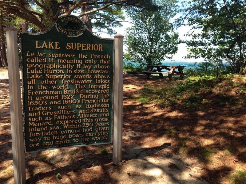
Le lac supérieur the French called it, meaning only that geographically it lay above Lake Huron. In size, however, Lake Superior stands above all other freshwater lakes in the world. The intrepid Frenchman Brulé discovered it around 1622. . . . — — Map (db m41968) HM
The Grand Island Nishnaabe had many of their spring, summer, and fall needs met on the island, but they also visited the mainland for seasonal foods and hunting. Sand Point provided luscious cranberries. The Anna River and other streams provided . . . — — Map (db m154478) HM
In the Ojibwa language, Munising is "Kitchi-Minissing" or "place of the island." Grand Island, the largest on Lake Superior's south shore, has a rich history.
From here, you can see "the thumb" and the eastern side of the main portion of the . . . — — Map (db m226652) HM
With the discovery of iron ore in Marquette County in 1844 and the opening of the Sault Locks in 1855, commerce and travel boomed on Lake Superior. Munising served not only as a port, but also as a harbor of refuge during storms. The first . . . — — Map (db m143346) HM
Local divers Pete Lindquist, Chuck Nebel, Tom Bathey, and John Stillman recovered this large anchor found buried in the sand of Munising Bay in 1980. The anchor is estimated to weigh over 1500 pounds. The anchor may have been lost by the barque . . . — — Map (db m154896) HM
"MEET ME AT COOK PARK, ALLEGAN, MICHIGAN"
The steamer Mildred carried passengers to and from Cook Park until about the time of W.W.I. The park was located at Cady's Grove, about three miles upriver from the dock behind the bank in Allegan, . . . — — Map (db m69899) HM
From about 1854 to at least 1863, this surfboat was used for lifesaving purposes near the Saugatuck Lighthouse. It was one of 48 used on the Great Lakes and one of 137 used nationally. Joseph Francis, owner of the Francis Metallic Lifeboat Company, . . . — — Map (db m182126) HM
Surveyed in 1839, the village of Pier Cove was once hailed as "the busiest port between St. Joseph and Muskegon." Before the Civil War, Pier Cove was a bustling community and a major point for lumber distribution, with ships departing daily carrying . . . — — Map (db m73498) HM
On its winding path to Lake Michigan, the Kalamazoo River separates the land of Saugatuck and Douglas. While the north bank pioneer settlements of Saugatuck and Singapore got their start in the 1830's, it was not until the 1850's that the opposite . . . — — Map (db m73643) HM
Settled in 1831 by the Hull Sherwood and Giles Scott families of Rochester, New York, the Pine Creek area was first called “New Rochester.” Allegan County’s first grist mill was constructed here in 1834, attracting customers from miles around, and . . . — — Map (db m74596) HM
You are near the center of Historic Saugatuck Township in River Bluff Park. The first settlers came here to a howling wilderness in the early 1830's. Within the township, Saugatuck is a half-mile to the west on the Old Allegan Road. Across the . . . — — Map (db m73604) HM
Shipbuilding forever changed with the transition from wooden hulls to those built of iron and steel. The first iron-hulled freighter on the Great Lakes, the Onoko, debuted in 1881. At 287 feet long, she was a giant of her day. Just five years . . . — — Map (db m122196) HM
At the time of the U.S. Civil War, thousands of sailing ships worked the Great Lakes. Despite their impressive numbers, these sailing vessels struggled hardly able to keep pace with the enormous demands for bulk cargos generated by America's . . . — — Map (db m122215) HM
Launched in 1891, the Grecian symbolizes an era of unprecedented industrial growth and dramatic changes in technology. Newspapers heralded the steamer and her five sister ships as “fast steel flyers.” A marvel of efficiency at . . . — — Map (db m126625) HM
In 1874, the 60-foot wooden harbor tug E.H. Miller began a 45-year career operating out of Alpena, escorting vessels on the Thunder Bay River and assisting those in distress. The tug was not without her own share of mishaps. In her first . . . — — Map (db m122200) HM
The maritime professionals who sail the ships on the Great Lakes are celebrating the 100th anniversary of their fraternal organization, the I. M. S. A. whose purpose is stated in the Association's constitution, "The purpose of this association's . . . — — Map (db m121889) HM
The screw steamer or "propeller" first appeared on the Great Lakes in the 1840s. These vessels featured wooden hulls and shallow bottoms like early sidewheelers, but their steam engines powered one or more screw propellers at the stern of the ship . . . — — Map (db m121898) HM
For centuries explorers and scientists have researched the Great Lakes. As a vital transportation link to the Midwest and one of the largest sources of fresh water on the planet. Such important resources warranted scientific, charting and survey . . . — — Map (db m122199) HM
Life on the frontier Great Lakes was dangerous when the sidewheeler Vermilion went into service in 1838. In 1842, the 151-foot steamer burned to the waterline, killing several people. A year later, with immigration booming and the economy . . . — — Map (db m122429) HM
Sailing ships first appeared on the Great Lakes when French explorer Rene Robert Cavalier, Sieur de La Salle built the Griffon in 1679. By 1870, over two thousand sailing ships plied the Great Lakes. Most of these sailing ships were . . . — — Map (db m122194) HM
Steam power first appeared on the Great Lakes in 1818. The earliest "steamers" were expensive to build and operate. Constructed of wood, the vessels had shallow bottoms and were powered by large sidewheels.
For a time, these "sidewheelers" . . . — — Map (db m121957) HM
In November of 1856, George N. Fletcher assisted a survey crew in laying the footprint for the city of Alpena. Appreciative of the area's dense forest and the Thunder Bay River's ability to help transport raw materials, finished products, and fuel, . . . — — Map (db m122228) HM
The Civil War created an insatiable demand for copper. At a time when Michigan's Upper Peninsula produced the majority of America's supply, vessels like the Pewabic played a critical role in the war effort. On a typical trip between lakes . . . — — Map (db m121896) HM
Located across the river from where you are standing is an area known historically as Alpena's Third Ward. The first dwellings there were erected in 1858 or '59 at the river's edge, while the majority of the land remained woods and swampland. The . . . — — Map (db m121894) HM
From the time of Alpena's inception it was divided by the Thunder Bay River, although most of the community was centered on the south side. A wooden scow served as a ferry, connecting Second Avenue on the south side with Dock Street on the north; it . . . — — Map (db m121890) HM
The first known fishing camp near Alpena was established on Thunder Bay Island in 1835. By the 1840s, both Thunder Bay Island and nearby Sugar Island served as a base for the area's fishing fleet, comprised entirely of sailing vessels. In 1846, . . . — — Map (db m121897) HM
From 1858 to 1926, Thunder Bay served as a major center of the Great Lakes lumber trade. Schooners and steamers shipped lumber around the Great Lakes and to eastern cities. Beginning in 1845, Thunder Bay Island also served as a "wooding," or fueling . . . — — Map (db m121895) HM
Like other "canallers," the schooner E.B. Allen squeezed through the canals and locks of the Great Lakes. Crews tried to maximize the payload, and thus profits, using every inch of cargo space.
The heavy traffic of thousands of sail and . . . — — Map (db m122198) HM
“By the Treaty of Saginaw, made at Saginaw [Saquina] September 24, 1819, by General Lewis Cass, Governor of the Northwest Territory, on the part of the United States, and the Chippewa Nations, Thunder Bay River became a part of the boundary of the . . . — — Map (db m182328) HM
Shipping on the Great Lakes has always been seasonal. The poor visibility, heavy seas and ice that came each year with the gales of November prompted ship owners and captains in the 1800s to "lay up" their ships. Every winter ice choked docks and . . . — — Map (db m121892) HM
Launched in 1891, the steel-hulled Grecian was built during an era of unprecedented
industrial growth and dramatic change in shipbuilding technology. Good steel flexes
but doesn’t break upon impact. However in June 1908, when the . . . — — Map (db m236369) HM
Built for speed, the 236-foot steam package freighter Montana
initially carried all types of freight. A typical trip found the
Montana carrying a diverse cargo of 6,000 barrels of flour, 40
tons of copper, 250,000 shingles, 100 . . . — — Map (db m236026) HM
On Saturday night, November 19, 1966, the Nordmeer was traveling to
Chicago from Hamburg, Germany, with a cargo of 990 coils of steel
destined for Milwaukee. It was the ocean-going vessel’s first freshwater
voyage. The night was clear. . . . — — Map (db m236019) HM
Shipwreck Alley.
For more than 12,000 years, people have traveled on the Great Lakes. From Native American dugout canoes to wooden sailing craft and steel freighters, thousands of ships have made millions of voyages on the Inland Seas. The . . . — — Map (db m236835) HM
What is this
NOAA
building?
This building houses
equipment that records Lake
Huron water levels, wind
speed and direction, air and
water temperature,
barometric pressure, and
relative humidity. It was
installed in 2006.
NOAA’s . . . — — Map (db m235924) HM
Since Alpena’s inception, the Thunder Bay River has bisected the city. Initially, a wooden
scow, pulled back and forth across the river with a rope, served as a ferry and connected
Second Avenue on the south side with Dock Street on the north. In . . . — — Map (db m235868) HM
Located across the river from where you are standing is an area
known historically as Alpena’s Third Ward. The first dwellings
were erected in 1858 or ’59 at the river’s edge, while the majority
of the land remained woods and swampland. In 1867, . . . — — Map (db m235736) HM
Shipping on the Great Lakes has always been seasonal. Poor
visibility, heavy seas and ice that arrive each year with the gales
of November prompted 19th-century ship owners and captains
to “lay up” their ships and take them out of active service . . . — — Map (db m235671) HM
Before America was discovered, indigenous people hunted and fished the Grand Traverse region for thousands of years. As far back as 8,000 B.C., the waters of Grand Traverse Bay, Elk River and the 14 lakes of Antrim County's Chain of Lakes had been . . . — — Map (db m98175) HM
In this photo you are standing on the other side of the Elk River and to the left side of the photograph. This picture of Elk Rapids is from the 1890s and the view is from the top of the Elk Rapids Iron Company's Furnace. What is left of this . . . — — Map (db m98173) HM
In 1856 Dexter and Noble Company began building an empire with their sawmill and mercantile business. In 1872 they built an iron smelting plant, one of the largest charcoal furnaces in the country. At each step of their building that empire, . . . — — Map (db m98125) HM
As shown in the above photograph taken in c1910, the Elk River and Chain of Lakes provided a means of transporting logs to the Dexter & Noble sawmill and a shoreline site where cord wood was made into charcoal fuel for the iron furnace. This . . . — — Map (db m98151) HM
Look carefully westward to see what remains of the Elk Rapids City Dock. This dock was one of
three docks situated within the village limits. It served the community of Elk Rapids from 1905
to 1911. The pier extended 1,440 feet out into East Grand . . . — — Map (db m247432) HM
It has often been asked, "Why the stumps in the river?"
In a way, the stumps tell the story of Elk Rapids. In the beginning the trees grew there while the land was still dry. As one can see in the photograph of the blast furnace, which was . . . — — Map (db m98135) HM
In 1850 George Thomas operated a sawmill here, and in the next decade as settlers began to arrive he built a gristmill. The new village, also known as Gull Lake, was a few miles south of the Reverend Leonard Slater’s Baptist Indian mission. Thomas . . . — — Map (db m191508) HM
This 9-inch Dahlgren Cannon is a true replica of those in place at Battery Park from the early 1900s to 1942. The originals were part of the arsenal aboard the USS Hartford, the flagship of Rear Admiral David G. Farragut. During the Civil . . . — — Map (db m182351) HM
This bay derives its name from the Sauk Indians who once dwelt by its shores. Adrien Jolliet, on his voyage down Lake Huron’s western shore in 1669, first made it known to the white man. In the late 1800's an immense lumber industry flourished in . . . — — Map (db m182360) HM
In 1894 William Jennison, a yachtsman for fifty years, founded the Bay City Boating and Fishing Club. The first clubhouse, located on the Saginaw River, was moved across the ice to this site around 1902. A larger, stylish building was soon erected. . . . — — Map (db m163334) HM
In 1873 an ambitious but ill-advised project was put through in an effort to connect Crystal Lake and Lake Michigan with a navigable channel. The original level of Crystal Lake was, at that time, much higher than its present level. The project was a . . . — — Map (db m97481) HM
On December 12, 1891, the Lighthouse Board issued a "Notice to Mariners" informing them that a long sought steam-powered fog signal, featuring two 10-inch whistles similar to those then used on locomotives, had been installed at Point Betsie. . . . — — Map (db m98327) HM
Yes, we have a gravestone at Point Betsie but alas no grave. Edward Wheaton, Keeper 1934 to 1946, made this gravestone to honor his mother, Martha Madsen Wheaton, 1857 to 1941. She died in Cheboygan.
Keeper Edward Wheaton could not lift the . . . — — Map (db m98323) HM
Prior to 1892, large quantities of kerosene that fueled Point Betsie's beacon and apartment lamps, etc., was kept at the base of the lighthouses tower. As at other light stations, a separate building was erected here in 1892 to provide safer . . . — — Map (db m98330) HM
People have lived on the terrace between Moccasin Bluff and the St. Joseph River for eight thousand years. The first inhabitants stayed in small temporary camps as early as 6300 B.C. The residents of A.D. 500 traded with groups in Indiana and . . . — — Map (db m217846) HM
St. Joseph and Benton Harbor once ranked among the nation's leading boatbuilding centers. From 1892 to 1955, waterfront facilities of the Truscott Boat Manufacturing Company, Dachel-Carter Shipbuilding Corporation, and Robinson Marine Construction . . . — — Map (db m68202) HM
Commercial fishing was one of St. Joseph's earliest maritime trades. Native Americans and the settlers who followed found the river and lake full of trout, whitefish, sturgeon, and perch. By the 1900s, family-run fisheries became major contributors . . . — — Map (db m68224) HM
Schooners rigged for sailing and steam-driven freighters were once common sights at St. Joseph and Benton Harbor. Fruit, lumber, and manufactured goods made up much of the port's early trade. By the 1870s, vessels were regularly carrying thousands . . . — — Map (db m68217) HM
The meeting of river and lake provided a natural setting for a harbor at St. Joseph. Human engineering would ultimately develop the port into one of the busiest on Lake Michigan.
In the 1830s, at the urging of local merchants, the U.S. Corps of . . . — — Map (db m68195) HM
The Great Lakes region is one of the nation's most important centers of maritime commerce. Lighthouses helped mariners navigate these vast inland seas. In 1832, the U.S. Government built the first lights on Lake Michigan at two of its busiest . . . — — Map (db m68176) HM
The north pier lighthouses, built in 1907, guide ships to this port. The inner light replaced a smaller, wooden lighthouse in use since 1847. The north pier was then extended and the outer light tower was added, allowing mariners to find the harbor . . . — — Map (db m68152) HM
During the late nineteenth and early twentieth centuries, local river captains, mill owners, merchants and other professionals built homes in this neighborhood. Over one hundred of their homes remain. They exemplify popular architectural styles . . . — — Map (db m64856) HM
Whether paddling a canoe, riding a riverboat, or sailing a yacht, pleasure boating has always been a favorite St. Joseph activity. Recreational boating has remained popular due to well-stocked fishing grounds and accessible private and city marinas. . . . — — Map (db m68216) HM
With a ready supply of lumber and a thriving port, St. Joseph and Benton Harbor offered a natural setting for shipbuilding. As early as the 1830s, sailing and steam-powered vessels were built here for lake and river navigation.
Shipbuilders . . . — — Map (db m68204) HM
Two historic waterways, Lake Michigan and the St. Joseph River, meet here. Opportunities for maritime trade, transportation, industry and recreation led to the founding of St. Joseph and Benton Harbor. Explore the Maritime Heritage Trail and . . . — — Map (db m68151) HM
Two historic waterways, Lake Michigan and the St. Joseph River, meet here. Opportunities for maritime trade, transportation, industry and recreation led to the founding of St. Joseph and Benton Harbor. Explore the Maritime Heritage Trail and . . . — — Map (db m68203) HM
A U.S. lighthouse supply depot was built at St. Joseph in 1893. For a quarter century, this depot equipped all of Lake Michigan's lights with materials ranging from lenses to lamp oil. Operations of the St. Joseph Depot were transferred to Milwaukee . . . — — Map (db m68218) HM
The waters off St. Joseph and Benton Harbor have long served as an active and frequently dangerous avenue of maritime trade. High winds and hazardous waves made shipwrecks a common occurrence.
To assist mariners, a U.S. Life Saving Service . . . — — Map (db m68194) HM
This cannon, captured in the Spanish-American War by Admiral Dewey, was presented to Three Oaks when its citizens raised $1,400 for a memorial to the men of the battleship Maine. This was the largest contribution, per capita, of any community in the . . . — — Map (db m1603) HM
George Ackerman, as a UCHS student, noted this spot on the river as a possible location for a dam. He went on to become a civil engineer. Around 1919, rising coal costs forced the village to turn toward hydro and they sought out . . . — — Map (db m95654) HM
In 1923, when the Riley Dam was built in the St. Joe to create hydro for the village, the 500+ acre backwater was known only as the “Municipal Pond.” There had not been enough time to clear the swampy land before damming, so trees were cut flush . . . — — Map (db m95243) HM
At this point the Coldwater and St. Joe Rivers join, creating their namesake “Union” City. In the late 1820s a road surveying party following the Washtenaw Indian Trail that later became M-60 stumbled upon this junction and returned giving a . . . — — Map (db m95217) HM
Union City’s infamous “Carp Rodeo” festival, a fundraiser for lake improvements, had several reincarnations around the area. The earliest ones were believed to have been held on Haughly Drive in the 1960s. In the 1980s, you could find the part in . . . — — Map (db m195160) HM
The first wooden bridge was built across the Coldwater River in 1843 with a steel bridge erected about 1895. The current bridge was constructed in the late 1950s. The Coldwater River starts from Coldwater Lake and meanders northwest 29.5 miles . . . — — Map (db m95164) HM
Union City's own “Daniel Boone,” Austin “Skinny” Bullock (1908-77), moved into this, his beloved Elkhorn Lodge, on the first day of
summer in 1952. He was a colorful
local legend who loved to hunt, trap and fish, earning his living by . . . — — Map (db m95241) HM
1926 UCHS graduate and creative
entrepreneur, Gerald Davison (1908-75) was the founder of Duo Coach Trailer (Marker #12). Upon selling that enterprise, he designed and built many unique Frank Lloyd Wright style homes in Union City and on Sycamore . . . — — Map (db m95240) HM
In the 1800s, Union City was the head to 170 miles of busy commerce on the St. Joe. Large freight barges poled by 8 men as well as steamers carried grain, pork, whiskey, flour, hides, furs, pig iron and
other goods manufactured along its banks . . . — — Map (db m95227) HM
Thanks to late 1800s area artist J.P. Palmer, many local river scenes were preserved in watercolor and oil. Moving here at age 10 from New York, he went on to study at Albion College and the Chicago Art Institute. His paintings were in great demand . . . — — Map (db m95653) HM
Early surveying parties sent out
on the Washtenaw trail, which
became M-60, took back glowing accounts of the potential for
water power at the junction of the two rivers and this quick stretch named the Coldwater Rapids.
The first race was . . . — — Map (db m95207) HM
The Arbogast Bridge is considered the east end of Union Lake. The wetlands surrounding the bridge are significant habitat to many types of birds and waterfowl. Keep your eye peeled for swans, sandhill cranes, loons, cormorants, heron, egrets, . . . — — Map (db m95400) HM
The first Broadway Bridge was constructed of wood in 1835. It was replaced with a steel structure in 1876. One of the largest bridges in Branch Co., it was washed out in the flood of 1908. Many locals who had been observing the floodwaters below . . . — — Map (db m95220) HM
On March 4,1908, heavy rains on top of 24" of snow followed by a thaw caused the rivers to spill over 4" above their highest known levels, submerging large sections of the village. The Broadway Bridge collapsed into the swollen river and was swept . . . — — Map (db m95156) HM
The Park Street Bridge was the second bridge built in Union City and originally wooden. The first steel span was erected in 1905. It was removed and replaced in 1974 with a new bridge at the cost of $141,000. The new bridge was renamed the Spencer . . . — — Map (db m95225) HM
In 1833 just behind this home a livery was first
deeded to feed and stable local horses. In 1913 it was known as Bell Livery Stable. In 1937, Mr. Densmore converted the livery to The St. Joe Tavern after moving the bar business from the Riverside . . . — — Map (db m95397) HM
Welcome to the J.P. Palmer Launch and starting point for the Union City Heritage Water Trail. Created and unveiled as part of the 2016 Sesquicentennial, the trail extends from this point on the Coldwater River west into the St. Joe River and ends 5 . . . — — Map (db m195159) HM
The small backwater to the left represents the exit of the millrace that was dug diagonally from the Coldwater River and powered saw and grist mills from the first settler in 1834 to 1949 when the 111 year old Randall Mill (below) caught fire. Six . . . — — Map (db m95223) HM
Samuel W. Hill, legendary figure of the northland, surveyed the Great Lakes’ harbors in 1840-44 and worked with Dr. Douglass Houghton on the first geological survey of the Upper Peninsula in 1845. He was later involved with the sale of land and the . . . — — Map (db m177245) HM
(Side A)
Big Rock Point
Big Rock Point is named for a large boulder used as a landmark by Native Americans. At least as early as the mid-nineteenth century Odawa (Ottawa) Indians used Big Rock, which they called Kitcheossening, as a . . . — — Map (db m97483) HM
Manitou Shoal Lightship,
ca. 1934.
Lighships were used to guide vessels
past certain hazardous navigation points
along Lake Michigan’s maritime lanes.
Manitou Shoal west of the Leelanau
Peninsula was one such spot. Until
1935, when a . . . — — Map (db m247384) HM
He survived the sinking of USS Perch (SS-176) and more than 3 years as a Japanese prisoner of war during World War II
He was a native of Charlevoix and was instrumental in building and maintaining this Memorial — — Map (db m98059) HM WM
Fishing and Lumbering - Round Lake, North ShoreTug Loaded with Lake Trout
ca. 1900
When Charlevoix was permanently settled in 1854, Lake Michigan teemed with millions of tons of fish, called "finny . . . — — Map (db m215844) HM
Fish Hatchery,
1930s.
Charlevoix’s US government fish
hatchery was built in 1917. When it
opened, it was the largest Federal
hatchery in the United States.
In recent years the building has served
as the State of Michigan's . . . — — Map (db m247401) HM
U.S. Navy Submarines paid heavily for their success in World War II.
A total of 374 officers and 3131 men are on board these 52 submarines
still on "patrol"
Albacore ·
Amberjack ·
Argonaut ·
Barbel ·
Bonefish ·
Bullhead · . . . — — Map (db m98057) HM WM
Hotel Alhambra, ca. 1935
The Lewis Grand Opera House was
constructed on this site, abutting the
channel, in 1883. Served the
community as a theater and meeting place
until the building was converted into
the red brick Hotel Alhambra in . . . — — Map (db m247391) HM
We the US Submarine Veterans of WWII
Michigan Chapter
proudly dedicate this memorial
to the gallant men of the
USS Escolar (SS294)
Lost by enemy action on or about
17 October 1944
while on her first patrol
with the loss of her . . . — — Map (db m98060) HM WM
Wharfside Building Acquisition
The 2002 purchase of the Wharfside Building (formerly known as Neff Brothers Quality Food Store) culminated the City of Charlevoix's one hundred and six year dedicated effort to purchase properties along the . . . — — Map (db m98056) HM
Looking North
from Washington (City) Park
ca. 1925. This image is taken
from about where
you are now standing.
Arrival of a Detroit & Cleveland
steamship at the McArthur Dock
at the mouth of the Cheboygan River,
ca. 1910.
Labor . . . — — Map (db m247268) HM
The name "Cheboygan" probably comes from the Annishinaabe or Chippewa word "zhiibaa'onaii," meaning a channel or passage for a canoe. This mural depicts some of the earliest known individuals to have made Cheboygan home during its beginnings. . . . — — Map (db m121797) HM
The Pipe:
Voyageurs often smoked white clay pipes as they travelled the waters of the Great Lakes region in their large freight-hauling canoes. Bodies of water were known as a "two-pipe lake" or "five-pipe crossing" depending on the number of . . . — — Map (db m121799) HM
Huron Shore Trail
follows the geologic Algonquin Beach Ridge formation along the western shore of Lake Huron from the Straits of Mackinac to Saginaw Bay. For centuries this trail was the primary travel route for Chippewa people travelling . . . — — Map (db m121805) HM
Huron Shore Trail
follows the geologic Algonquin Beach Ridge formation along the western shore of Lake Huron from the Straits of Mackinac to Saginaw Bay. For centuries this trail was the primary travel route for Chippewa people travelling . . . — — Map (db m121887) HM
River mouth and cattail marsh:
Captain Samuel Robertson wrote in the 1770s, "…the most safest place near Michilimackinac [Mackinac Island] for wintering vessels is the River Shaboygan, there is six feet water upon the Barr, the River is about . . . — — Map (db m121888) HM
520 entries matched your criteria. The first 100 are listed above. Next 100 ⊳