On Old Marlton Pike at Jones Road, on the right when traveling west on Old Marlton Pike.
Inherited by Elwood Haines in 1847 from his father Jonathan Haines, the property was later sold to the Cochley family, who sold it to the Singer family in the 1930’s. — — Map (db m44775) HM
On Branch Street at Filbert Street, on the right when traveling east on Branch Street.
Burials are thought to have started here in the 1820's. The earliest legible date is 1836. Old area family names include Braddock, Prickett, Riley, Kirby and Stackhouse. — — Map (db m44779) HM
On Main Street at 4th Street, on the left when traveling north on Main Street.
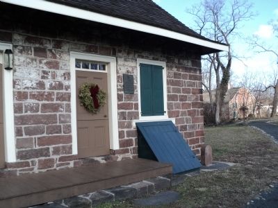
The home of the Campbell Soup Company's founder
As a child in deep South Jersey, Joseph Campbell likely could not dream how successful his life would be – and he would have been stunned to learn that nearly two centuries later his . . . — — Map (db m194857) HM
On Kings Hwy E (New Jersey Route 41) at Roberts Avenue, on the left when traveling north on Kings Hwy E.
In 1960, the Historical Society of Haddonfield (HSH) purchased Greenfield Hall for its headquarters. As part of its mission to document and preserve the history of the area, HSH has maintained this building and the adjacent Mickle House to . . . — — Map (db m225592) HM
On Kings Hwy E (New Jersey Route 41) at Roberts Avenue, on the left when traveling north on Kings Hwy E.
The front portion of this structure, built c.1736, on a lot on Kings Highway west of the Indian King Tavern, served as Samuel Mickle's saddler's shop. Elizabeth Haddon Estaugh purchased this building in 1752 from Mickle's estate, possibly . . . — — Map (db m225584) HM
Near Berlin Kresson Road (Route 73), on the right when traveling south.
Grover Cleveland 22nd and 24th President of the United States It is believed that after his second term he stayed in this home on his travels to New Jersey. He would often visit Brigantine, retired to Princeton and the town of Folsom is named . . . — — Map (db m174333) HM
On Hughes Street north of Stockton Place, on the right when traveling south.
The Cherry House was built in 1849 by Lemuel Leaming, member of the pioneer Leaming family, noted for its development of Cape May County. In the late 1850s it was the home of James Mecray first burgess of Cape Island which in 1875 officially . . . — — Map (db m206389) HM
Near Light House Avenue (County Road 629) at Lehigh Avenue, on the left when traveling south.
This structure was built in 1893 to house the kerosene used to power the light.
Lighthouses were generally powered by Sperm Whale oil until its price rose dramatically in the 1850s. In the mid-1870s, kerosene, which was less expensive than . . . — — Map (db m206416) HM
On Myrtle Avenue west of Park Boulevard, on the left when traveling west.
West Cape May Remembers…
The things that aren't here anymore…
The Goldbeaten Industry
The Goldbeaten industry was started by George Reeves in 1864 behind his home. In 1881, he built a two-storey factory on . . . — — Map (db m206407) HM
On Washington Street at Main Street, on the right when traveling west on Washington Street.
As a respected member of the local community and the last surviving enslaved person of Essex County, Anthony Thompson's life journey took him from being someone's property to becoming a free man and property owner in West Orange. He was born into . . . — — Map (db m173382) HM
Restoration of the New Ferry Building on Ellis Island is being supported in part by a Federal Save America’s Treasures award administered by the National Park Service, Department of the Interior. New Ferry Building In 1999, the Statue of . . . — — Map (db m49291) HM
An Adventure in Stabilization Ellis Island The 29 buildings on the south side of Ellis Island comprise one of the largest hospitals to be built in the United States during the first decades of this [20th] century. With more than a quarter . . . — — Map (db m49309) HM
Hunt family was major benefactor to Glen Gardner. House owned by Dr. A.A. Hunt in late 1700's. House across street built by his son, Dr. T. E. Hunt, in 1853. — — Map (db m17410) HM
Near Stockton Street (U.S. 206) just west of Monument Drive, on the right when traveling west.
Morven's Carriage House dates to the last decade of the 19th century. When the Morven property was subdivided in 1891, the land containing Morven's stables was sold. This frame building, a combination stable and carriage house, was built to fill . . . — — Map (db m208134) HM
Near Stockton Street (U.S. 206) just west of Monument Drive, on the right when traveling west.
This building first functioned as an Ice House (the ice chamber is still accessible through the small door beside the Museum Shop). Constructed for Richard Stockton the Duke (1764-1828), it would have been a novelty in the 18th century. Ice was . . . — — Map (db m208137) HM
Near Stockton Street (U.S. 206) just west of Monument Drive, on the right when traveling west.
After Bayard Stockton died in 1928, Robert Wood Johnson Jr., head of Johnson & Johnson, rented Morven. He used it as a comfortable suburban retreat, keeping horses in the stable and adding recreational facilities. In 1939, he had plans drawn up . . . — — Map (db m208144) HM
On Lamberton Street north of New Jersey Route 29, on the left when traveling north.
William Trent, merchant of Philadelphia, builds the brick mansion, today known as the Trent House, on land purchased from Mahlon Stacy, Jr. — — Map (db m211696) HM
On Lamberton Street north of New Jersey Route 29, on the left when traveling north.
The Ancient Free and Accepted Masons erect the Masonic Lodge, one of Trenton’s most prominent 18th century institutional buildings — — Map (db m211716) HM
On Morris Street just east of Livingston Avenue (New Jersey Route 171), on the right when traveling east.
The Henry Guest House is the second oldest structure in New Brunswick. In 1760, Alderman Henry Guest, a tanner, constructed this sturdy home of native stone near the bank of Lyell's Brook at what later became the corner of Livingston Avenue and New . . . — — Map (db m208907) HM
On Green Street at School Street, on the left when traveling west on Green Street.
Pre 1879
Original house constructed
1943-1969
Dr. Fred and Stephanie Kessler
Residence and Doctor's Office
Hyatt home since 1969 — — Map (db m234208) HM
On Mattison Avenue at Emory Street, on the left when traveling north on Mattison Avenue.
Woodrow Wilson, 28th President of the United States, used the entire fifth floor of this building for his executive offices during the late summer and early fall of 1916 while he vacationed at Shadow Lawn, the Summer White House at West Long . . . — — Map (db m5240) HM
On September 11, 2001, many came to this site to witness the horrific tragedy just a few miles away in Lower Manhattan, and, for days afterward, they continued to come to view the smoke spiraling up from the site, most still in shock, not believing . . . — — Map (db m5981) HM
On Route 537 West at Heyers Mill Road on Route 537 West.
Tavern and stagecoach stop on The Burlington Path—from the Atlantic Coast to the Delaware River. Owned by the widow Hart, the wife of Joshua huddy. — — Map (db m15630) HM
One of 6 "one room" schoolhouses, originally known as the Barrenton School was moved to its present site, and became the Montrose School. Operation ceased in 1922 with the construction of the Atlantic School on Rt. 537. — — Map (db m15628) HM
Near Light House Road, 0.1 miles south of Twinlights Terrace, on the left when traveling south.
The Navesink Highlands overlooks the major shipping channels in and out of New York Harbor. From here, 200 feet above the ocean, there is unobstructed visibility on a clear day for 22 miles out to the horizon. This is one of the reasons the . . . — — Map (db m208259) HM
On Light House Road, 0.1 miles south of Twinlights Terrace, on the left when traveling south.
Originally located at Spermaceti Cove on Sandy Hook, this station was one of the first built in the U.S. The station contained apparatus for rescue of shipwreck survivors. The U.S. Lifesaving Service and the U.S. Revenue Cutter Service merged in . . . — — Map (db m208248) HM
Near Lighthouse Road. Reported permanently removed.
The Navesink Highlands Light Station originally consisted of two octagonal stone towers 320 feet apart. You are standing directly on the site of the 1828 north tower. Its replacement, completed in 1862, is behind you.
[Caption:] . . . — — Map (db m22621) HM
On Hartshorne Drive, on the right when traveling north.
When Officers Row was built, this site was left vacant to allow space for the West Beacon Range Light. Ships traveling across Raritan Bay would line up the lighthouse and beacon lights to mark their way. After the West Beacon was demolished in the . . . — — Map (db m54511) HM
On Kessler Road, on the right when traveling north.
The BOQ housed unmarried officers. Captains and majors lived on the second floor in their own suites with private baths and sitting rooms. Lieutenants occupied single bedrooms and shared a bathroom on the top floor. The first floor was the original . . . — — Map (db m54519) HM
On Kearney Road at Jackson Street, on the left when traveling north on Kearney Road.
Every day at the Post Bakery, fresh bread was made for the mess halls and for sale at the Post Commissary. At 3 a.m. each morning soldiers would begin baking bread to feed the hundreds of troops who would report to the mess hall at 6 a.m., noon, . . . — — Map (db m54496) HM
On Kessler Road, on the left when traveling north.
Enlisted men lived on Barracks Row facing the parade ground. The four identical buildings each held a full battery of 80 soldiers. The U-shaped double barracks on the far right, built in 1909, held two batteries. Each barracks had its own mess . . . — — Map (db m54516) HM
On Kearney Road, on the left when traveling south.
This barracks was built for the enlisted men at the Sandy Hook Proving Ground. After the proving ground moved to Aberdeen, Maryland, in 1919, it became the Fort Hancock School and later Headquarters for the 7th Coast Artillery Regiment. Sandy Hook . . . — — Map (db m54534) HM
On Kearney Road at Canfield Road, on the left when traveling north on Kearney Road.
Cannon and artillery projectiles were not the only weapons tested at the Sandy Hook Proving Ground. Rifles, machine guns, and new types of gun powder and explosive fuses were tested there. At the chemistry lab, explosive and propellant compounds . . . — — Map (db m54529) HM
Fort Hancock’s barracks originally included barber and tailor shops, a kitchen, and a mess hall. After a few years, the army wanted more bunk space and these operations were moved to new detached mess halls built directly behind each barracks. . . . — — Map (db m54439) HM
On Magruder Road at Hudson Road, on the left when traveling north on Magruder Road.
The Fort Hancock Gas Station was operated by the Post Exchange. It was the only filling station on post where soldiers with privately owned vehicles could buy fuel or have them serviced. Fort Hancock was in operation from 1895 to 1974. — — Map (db m54438) HM
On Kearney Road at South Bragg Road, on the left when traveling north on Kearney Road.
Fort Hancock’s first fire station was manned by enlisted soldiers who were the post’s firefighters. The tower at the rear of the building was used for drying hoses. Today this is the National Park Service Sandy Hook fire fighting station. Fort . . . — — Map (db m54497) HM
On Canfield Road, on the left when traveling north.
This stately structure was officers’ quarters for the Sandy Hook Proving Ground until it moved to Aberdeen, Maryland, in 1919. It housed Fort Hancock officers until 1936, then it became the Officers’ Club and its red brick exterior was painted . . . — — Map (db m54521) HM
On Kearney Road, on the right when traveling south.
When World War II began in Europe in 1939, the U.S. Army numbered 175,000 men. By the time of Pearl Harbor in December 1941, the army had swelled to over 1.5 million. To accommodate this influx, temporary wooden “mobilization” building like these . . . — — Map (db m54536) HM
On Kearney Road at Lawson Lane, on the right when traveling north on Kearney Road.
Like any small town, Fort Hancock had a jail. Military life was strict and a soldier could be punished for an offense as minor as being outside his barracks after lights-out. Military penalties could include loss of rank, heavy fines, . . . — — Map (db m54466) HM
On Kearney Road at Canfield Road, on the left when traveling north on Kearney Road.
The senior railroad engineer, who ran Sandy Hook’s locomotives, lived here. An extensive military railroad system carried guns and ammunition to the Sandy Hook Proving Ground and later supplied all of Fort Hancock. Today, the building is used as a . . . — — Map (db m54532) HM
On Kessler Road, on the left when traveling north.
Eighteen houses comprise Officers Row; each was home to an officer and his family. Traditionally, officers’ homes faced toward the parade ground. Here however, army architects placed them facing Sandy Hook Bay to take advantage of the cool summer . . . — — Map (db m54503) HM
On Kearney Road at McNair Road when traveling north on Kearney Road.
The commissary was a storage warehouse for provisions such as sugar, flour, coffee, canned meats, and other food stuffs needed at the mess halls. The commissary also had a small shop where army personnel and civilian employees living on post could . . . — — Map (db m54489) HM
On Kearney Road, on the right when traveling south.
Here the commanding officer and his staff ran the day-to-day operations of Fort Hancock. A post of this size was usually commanded by a colonel. During World War II, Fort Hancock was headquarters for all New York Harbor Defenses under the command . . . — — Map (db m54483) HM
On Kearney Road, on the left when traveling south.
This was the home for one of the foremen at the Sandy Hook Proving Ground. After the proving ground closed in 1919, it was used for housing noncommissioned officers and their families. Today, this building is a residence for National Park Service . . . — — Map (db m54533) HM
This warehouse was used to store uniforms, blankets, furniture, and other personal supplies for Fort Hancock’s garrison. The “Fort Hancock” painted on the roof was a marker for pilots. This was originally a two-story building and the third story . . . — — Map (db m54491) HM
On Kearney Road at Lawson Lane, on the right when traveling north on Kearney Road.
Noncommissioned Officers and their families lived in this row of houses. Single NCOs lived in the barracks with their men. Today, these homes are residences for National Park Service staff. Please respect their privacy. Fort Hancock was in . . . — — Map (db m54469) HM
On Ocean Avenue North at Pavillion Avenue, on the left when traveling north on Ocean Avenue North.
Long Branch Post 316
Jewis War Veterans
of the USA
through whose efforts
Oceanpointe Towers was erected
dedicates this site
in honor of the men and women who have served in our nation's armed forces and in memory of those who made . . . — — Map (db m209106) HM WM
On Kessler Road, on the right when traveling north.
This officer’s home, designed for a lieutenant and his family, was a testament to the rank and privilege of officers in the small peacetime army of the late 19th century. Fort Hancock was in operation from 1895 to 1974. — — Map (db m54508) HM
On McNair Road at Lawson Lane, on the left when traveling north on McNair Road.
This building was Fort Hancock’s original gymnasium and in 1941 became the Post Exchange or PX. Soldiers could buy personal items here or go bowling at the four-lane alley located in the basement. The cost for a game in 1942 was 15 cents. Fort . . . — — Map (db m54470) HM
On Kessler Road, on the right when traveling north.
Soldiers could catch the latest films of the day at the Post Theater, which seated 300. The average ticket price in the 1930s and 1940s was ten cents. Fort Hancock was in operation from 1895 to 1974. — — Map (db m54506) HM
On Drs James Parker Boulevard east of Bridge Avenue, on the left when traveling east.
Maple Hall served as the home of the African American journalist T. Thomas Fortune from 1901 to 1908. Born into slavery in 1856 and freed by the Emancipation Proclamation of 1863, Fortune rose to prominence during his more than twenty-year . . . — — Map (db m206009) HM
On Myrtle Avenue (U.S. 202), on the left when traveling north.
The DL&W Railroad built this prairie style station in 1904. Passenger trains served the growing commuter population. Freight trains delivered coal to heat homes and power local mills, then departed with products headed to market. Morris . . . — — Map (db m33493) HM
This 1785 house has an 1837 wing built by forge owner John Decker featuring spoon-worked plaster walls and an enigmatic folk art face wall painting. Land preservationist Oscar Kincaid, Jr. lived here. The Kincaid family operated the farmstand from . . . — — Map (db m91199) HM
On Myrtle Avenue (U.S. 202) at Main Street (County Route 511), on the left when traveling north on Myrtle Avenue.
Dr. Taylor resided and practised medicine here. Dwelling purchased 1921 by town of Boonton as memorial to World War I veterans. Town Hall until 1965. Headquarters, Post 124, American Legion. — — Map (db m192212) HM
On Loantaka Way, on the right when traveling north.
William Gibbons, prominent racing patron, built stable to house his thoroughbred racehorses, including Fashion, "Queen of the American Turf". Barn is outstanding example of an early 19th century horse barn. — — Map (db m192217) HM
On Southern Blvd at Fairmount Avenue, on the left when traveling south on Southern Blvd.
Built around 1860 as one room schoolhouse. Served until 1928 as one of four township schools. Renovated as Chatham Township Hall 1959. — — Map (db m8879) HM
On Main Street (New Jersey Route 24), on the right when traveling west.
Federal style structure built for Zephaniah Drake as stage coach stop. Purchased 1854 by William Rankin who added two wings, and converted inn to Chester Institute. — — Map (db m20328) HM
Original gristmill circa 1788. Owned by Elias Howell. Present gristmill built 1826 by Nathan Cooper. Only surviving structure of the industrial community, Milltown, — — Map (db m20322) HM
Original farmhouse owned by Abraham Kitchel, Revolutionary patriot.
New Jersey legislator and Morris County Judge. Dwelling enlarged and outbuildings built during 19th century. Kitchel family occupied property until 1927. — — Map (db m94691) HM
A Revolutionary tavern, owned by Colonel Ellis Cook, member of the Morris County Militia. The tavern derived its name from Sussex County farmers who stopped here enroute to Newark markets. Morris County Heritage Commission New Jersey Register . . . — — Map (db m32272) HM
On Ridgedale Avenue at Columbia Turnpike (County Route 510), on the right when traveling south on Ridgedale Avenue.
Built on site of 1830 wooden school. Present structure predates Florham Park borough by 33 years. Classes held here continuously until 1914. Morris County Heritage Commission New Jersey Register of Historic Places National Register of . . . — — Map (db m36415) HM
On Jockey Hollow Road at Sugarloaf Road, on the right when traveling south on Jockey Hollow Road.
When Washington’s soldiers camped in Jockey Hollow, they occupied parts of blacksmith Joshua Guerin’s land. Parts of this house stood here then. — — Map (db m8819) HM
Near Jockey Hollow Road, on the right when traveling south.
Henry Wick lived here. His main cash crop – several hundred trees – fixed him more comfortably than most New Jersey farmers of his day. Suddenly in December, 1779, 10,000 hungry soldiers became his guests. Many of them camped on his . . . — — Map (db m8822) HM
Built by Theodore F. King C.1878, photo below late 1890’s.
Miss Louise King was born in this house in 1881 and lived here until her death in 1975. In 1963 she donated the land next to the King Store for the relocation of the Silas Riggs House . . . — — Map (db m91422) HM
On Main St. at Green Village Rd., on the left when traveling north on Main St..
Constructed with funding provided by philanthropist D. Willis James. This 1900 Romanesque revival edifice has an interior featuring medieval inspired stenciling, glass, and ironwork. In 1969, it became the Museum of Early Trades and Crafts. Founded . . . — — Map (db m157156) HM
Near Madison Avenue, on the right when traveling east.
Greek Revival mansion, built by William Gibbons, part of estate, "The Forest". Purchased 1868 by Daniel Drew for Drew Theological Seminary. Mansion named for Roxanne Mead Drew.
New Jersey Register of Historic Places — — Map (db m32994) HM
Near Jockey Hollow Road near Hardscrabble Road, on the right when traveling east.
Whether you call the mansion before you "Queen Anne Farm" as the Bensels did, or Hardscrabble House as the Cross Family renamed it, the estate served as an escape from everyday life.
John A. and Ella Bensel built the house in 1905, and William . . . — — Map (db m18311) HM
On New Jersey Route 24 at Hilltop Road, on the right when traveling west on State Route 24.
Farmhouse home of Ebenezer Byram, one of Mendham's founding fathers. In 1742 opened as tavern to travelers. In continuous operation as hostelry over two hundred years. — — Map (db m18219) HM
On Union Schoolhouse Road at Mosele Road & Pleasant Valley Road, on the right when traveling south on Union Schoolhouse Road.
Built and operated as a one room school until 1928, when students transferred to Mendham Borough School. Remodelled as private dwelling after acquisition by Schiff Scout Reservation, 1941 — — Map (db m16981) HM
On Long Hill Road, on the right when traveling south.
Built in early 19th century as one room school. Classes held continuously until 1926. Addition added 1910. Since 1928 used as Passaic Township Hall. Public school classes discontinued in 1933. — — Map (db m32987) HM
Original dwelling built by Ebenezer Stiles about 1752. Lighthorsemen quartered here during Revolution. House enlarged 1868 by Jonathan Roberts, founder of Library Association 1881. — — Map (db m33491) HM
On Mt. Kemble Avenue (U.S. 202), on the right when traveling south.
Oldest schoolhouse still standing in Morris township. Addition built in 1899. School held here continuously from 1810-1914. Morris County Heritage Commission — — Map (db m8595) HM
Near Speedwell Avenue (U.S. 202), on the right when traveling north.
An inventory of Stephen Vail’s property showed that he owned two carriages, two sleighs, two wagons and two buggies. This simple, one story building was used as extra storage for the Vail family’s vehicles. Its double sliding doors face the main . . . — — Map (db m32874) HM
On Lafayette Avenue at Kary Way, on the right when traveling west on Lafayette Avenue.
Victorian Italianate house purchased by Augustus Crane 1857. Home until 1971 of Crane- Hone family who contributed greatly to Morristown civic, cultural and business life. National Register of Historic Places New Jersey Register of Historic . . . — — Map (db m36406) HM
On Lafayette Avenue at Kary Way, on the right when traveling west on Lafayette Avenue.
Acorn Hall was built in 1853 and remodeled in the Italianate Villa style in 1860; the Crane/Hone family lived here from 1857 to 1971. The house and its interiors were preserved through the efforts of the Crane/Hone women. Mary Bolles Crane, . . . — — Map (db m36428) HM
On Madison Avenue, on the right when traveling east.
Built during Morristown’s Gilded Age for General Edward Meany, New Jersey Advocate General, 1893, and a Director of American Telephone and Telegraph Company. Architecture reflects English Medieval Castle influence. — — Map (db m42203) HM
On Madison Avenue, on the left when traveling east.
Built by the Community Morristown resident Myra Brookfield, determined that her hometown should have its own hospital, bequeathed her house and property on DeHart Street for just that purpose in the late 1800s. A community-wide . . . — — Map (db m117446) HM
On Olyphant Place, on the right when traveling north.
Home of Jabez Campfield, where Alexander Hamilton courted Betsy Schuyler in 1780. Her uncle, Surgeon General of the Continental Army, Dr. John Cochran, quartered here. — — Map (db m7360) HM
On Maple Avenue at Madison Street, on the right when traveling south on Maple Avenue.
Gothic revival building is oldest standing church in Morristown. Replaced 1848 wooden church which ministered to Irish immigrant families in surrounding Dublin area. Morris County Heritage Commission New Jersey Register of Historic Places . . . — — Map (db m32678) HM
On South Street at Community Place, on the left when traveling north on South Street.
Dr. Condict, outstanding public servant, was first president of the Morris County Medical Society, congressman, and first president of the Morris and Essex Railroad. Morris County Heritage Commission New Jersey Register of Historic Places . . . — — Map (db m42208) HM
Near Speedwell Avenue (U.S. 202), on the right when traveling north.
The Ford Cottage was built in the early 18th century by Gabriel Ford Jr., the grandson of Col. Jacob Ford Sr., Ironmaster, tavern owner and one of Morristown’s wealthiest citizens. Jacob Ford, Jr., was the builder of the mansion used by . . . — — Map (db m32887) HM
On Morris Avenue, on the left when traveling east.
The Army is quartered within three Miles of this place, in the usual way of hutting. Head Quarters is in this Town, at the Widow Fords, at the great white House at the North end of the place.Major General Nathaniel Greene, December 25, . . . — — Map (db m114771) HM
On Kahdena Road at Knox Hill Road, on the left when traveling north on Kahdena Road.
Neo-gothic house built by General Joseph Revere, grandson of Paul Revere. Purchased 1881 by Charles Foster, whose daughter, Caroline, donated the property as living farm to Morris County Park Commission in 1973. Morris County Heritage . . . — — Map (db m42209) HM
Near Speedwell Avenue (U.S. 202), on the right when traveling north.
When not managing the Ironworks, Stephen Vail was often traveling in search of business. The Homestead Carriage House was his center for transportation. The main floor was used to store carriages for the summer and sleighs for the winter. Horses . . . — — Map (db m32876) HM
Near Speedwell Avenue (U.S. 202), on the right when traveling north.
The L’Hommedieu House is an excellent example of late 18th/early 19th century domestic architecture. This stylish town house originally stood on Spring Street in Morristown on a lot first owned by Nathaniel L’Hommedieu and later sold to John . . . — — Map (db m32911) HM
209 entries matched your criteria. The first 100 are listed above. Next 100 ⊳