On Farragut Avenue near Sampson Road, on the right when traveling east.
With the surrender of Japan and the close of hostilities in August, 1945, a call resounded across the nation to “bring our boys back home.” A demobilization center was established at Great Lakes to process the discharge of sailors. In . . . — — Map (db m37926) HM
On Farragut Avenue near Sampson Road, on the right when traveling east.
Early aviation at Great Lakes included both pilot training and schools for enlisted Aviation Quartermasters, Machinists Mates, Aviation Armorers, and Ordnancemen. The first pilots were from among wealthy Illinois families who not only encouraged . . . — — Map (db m37873) HM
On Farragut Avenue near Sampson Road, on the right when traveling east.
During the astonishing growth of the Navy during World War I, women were, for the first time, accepted into the Navy. These women enlisted into the yeoman rating and were designated with an (F) for female. They served with the aviation unit and . . . — — Map (db m37925) HM
On Farragut Avenue near Sampson Road, on the left when traveling east.
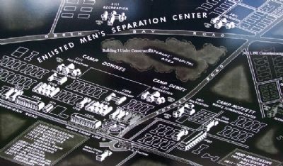
World War IOn April 6, 1917, less than six years after Great Lakes was opened, the U.S. declared war on the Central Powers. By August, the number of trainees grew from 618 to 50,000. Vast tent cities sprang up to house the flood of volunteers. . . . — — Map (db m37996) HM
On Farragut Avenue near Sampson Road, on the right when traveling east.
On the morning of December 7, 1941, only 6,814 sailors were in training at Great Lakes. Two hours after the attack began, Captain Spaulding, the Public Works Officer, authorized a large construction program. 13 prime contractors, 27 architectural . . . — — Map (db m37920) HM
Near Bloomington Avenue (Illinois Route 23) north of North 21st Road/West Main Street (County Route 6), on the right when traveling north.
John Huston Finley was born on a farm east of Grand Ridge and attended Grand
Ridge Elementary School. He graduated from Ottawa High School as valedictorian in
1882, and earned his undergraduate degree at Knox College in 1887. He went on to
Johns . . . — — Map (db m239246) HM
On 7th Street west of Union Street, on the right when traveling west.
Dr. Paul Carus
Born July 18, 1852, Ilsenburg in Harz, Germany
Died February 11, 1919, LaSalle, Illinois
Dr. Paul Carus, who lived and worked at 1307 7th St, LaSalle, Illinois, was editor of the Open Court Publishing Company & The Open . . . — — Map (db m65300) HM
On East Canal Street at Vine Street, on the right when traveling east on East Canal Street.
This one room schoolhouse was originally established as District One in a deed notarized by Horace D. Hickok, brother of "Wild Bill" Hickok on August 8, 1865. It was later referred to as the Aitken School after John Malcolm Aitken, a stalwart friend . . . — — Map (db m185193) HM
On West Walnut Street (County Road 23) at East 350 Road, on the right when traveling east on West Walnut Street.
Named after Henry Cox, farmer and jeweler, who donated the land.
A one room, one teacher school stood on this corner until 1976. Teachers served the surrounding community in the school until 1954.
Dedicated to Blanche Maher, (1943 until 1954), the . . . — — Map (db m191419) HM
On West Madison Street just east of La Salle Street (Illinois Route 23), on the left when traveling west.
In memory of W.R Foster (1863-1957)
Superintendent of LaSalle County schools for 40 years from 1907 to 1947.
Educator, civic leader and man outstanding, able, inspiring, helpful, humorous, and loyal-- who enriched the lives of hundreds . . . — — Map (db m198468) HM
On North Park Street (Illinois Route 23) just north of East Hickory Street, on the right when traveling north.
Streator’s founding father was a noteworthy politician, successful businessman, courageous patriot and remarkable humanitarian. His helping hand, hopeful words, and loving heart were devoted to the service of humanity; his greatest gifts were his . . . — — Map (db m185073) HM
On North Bloomington Street (Illinois Route 23) just north of El Camino Court, on the right when traveling north.
”I always wanted to know what’s on the other side of the mountain.” —Clyde Tombaugh A Life of Discovery Clyde Tombaugh's love of astronomy began as a young boy growing up near Streator. At age 24, he became famous for . . . — — Map (db m177433) HM
On County Route 1570E at County Route 1200N, on the right when traveling east on County Route 1570E.
America at war in 1942 needed new bases to complete the training of its Army Air Corps cadets before they joined combat groups overseas. "Allison Prairie" in Lawrence County, Illinois, provided ideal conditions for a field due to its size and varied . . . — — Map (db m178179) HM
On South Hennepin Avenue, on the right when traveling south.
Books which young Ronald Reagan borrowed from the Dixon Public Library helped him shape lifelong values. At nine years of age in 1920 he received card number 3695, becoming a frequent Library visitor and an avid reader throughout his Dixon years. . . . — — Map (db m78275) HM
On Reagan Way / South Hennepin Avenue south of West 9th Street, on the right when traveling south.
The Reagan family—Jack, Nelle, and their two sons, Neil (age 12) and Ronald (age 9), moved to Dixon and into this house on December 6, 1920. The boys attended school at South Side School, later known as South Central School, just four blocks . . . — — Map (db m78281) HM
On South Hennepin Avenue / Reagan Way at West 9th Street, on the right when traveling south on South Hennepin Avenue / Reagan Way.
Hennepin Avenue was often walked by a young Ronald Reagan from home to downtown and back. The street has four landmark institutions that played a vital role in the development of his character. They include the boyhood home, the grade school, now . . . — — Map (db m78280) HM
On Prairie Street at North Ladd Street, on the right when traveling east on Prairie Street.
Civic leaders welcomed Route 66 through Pontiac in 1926 as a boon for business. However, parents were concerned about their children crossing this "dangerous speedway.' As a solution, the State Highway Commission excavated a tunnel under the . . . — — Map (db m158311) HM
This stone is from the façade of the Atlanta Public School constructed in 1870 to replace the town's original Seminary Building. The 1870 school included 10 schoolrooms, a spacious recital hall, and an office. An $800 Seth Thomas, four-dial clock . . . — — Map (db m162539) HM
This was the cornerstone of the Atlanta High School, constructed in 1909. When the Atlanta Community Unit School District #16 consolidated with the Olympia Community Unit School District #16 in the early 1970s, the Atlanta High School was . . . — — Map (db m162540) HM
On Bohan Street west of North Bogardus Street, on the right when traveling east.
This is a 1917 Krupp K-14 Light Artillery Cannon which was brought to the Elkhart community in the early 1920s where it was displayed at the Elkhart Community High School until the mid 1970's. The High School closed and the cannon was moved to the . . . — — Map (db m159584) HM
On Memorial Park Road south of 1520 Street, on the right when traveling south.
The Lincoln Chautauqua was a popular educational movement from 1902 to 1937. When Chautauqua came to town, it brought speakers, teachers, musicians and entertainers of the day. The grounds had approximately 100 private cottages with lights, water . . . — — Map (db m159310) HM
On Keokuk Street west of Ottawa Street, on the right when traveling west.
On Abraham Lincoln's last birthday, February 12, 1865, ground was broken for Lincoln University, now Lincoln College. The town proprietors, Robert B. Latham, John D. Gillett and Virgil Hickox, donated the tract of land for the original campus, and . . . — — Map (db m105968) HM
On South Maple Street north of 7th Street, on the left when traveling north.
The Niebuhr family, called “The Trapp Family of Theology” by Time magazine, produced four distinguished professors of Christian studies. In 1902, the Rev. Gustav and Lydia Niebuhr came to Lincoln, where he became pastor of St. John’s . . . — — Map (db m105975) HM
On Madison Street, on the left when traveling south.
Middletown was founded in 1832 by Hiram S. Allen. Middletown was an excellent business location because stagecoaches already ran through the area, going from Springfield to Galena, carrying both passengers and mail. The first lot to be sold in . . . — — Map (db m41279) HM
On Washington Street, on the right when traveling north.
Mid-19th Century Lawyers riding the eighth judicial circuit sometimes found that local accommodations left much to be desired. If they were lucky, a prosperous local resident would invite them into their home. If not, they were at the mercy of . . . — — Map (db m41239) HM
On Washington St., on the right when traveling north.
Lincoln illustrator Lloyd Ostendorf imagined this scene in connection with Mt. Pulaski's "cast iron tombstone" case that Lincoln handled on appeal in the Illinois Supreme Court in Springfield (1859). Two local residents separately sued Reuben Miller . . . — — Map (db m41242) HM
On Boiling Spring Road, on the right when traveling south.
John Hanks was born in 1802 in Kentucky, he was a second cousin of Abraham Lincoln through Lincoln's mother, Nancy Hanks Lincoln. John Hanks stated that he first knew Lincoln when he was a boy of twelve in Spencer County, Indiana. However, it . . . — — Map (db m41240) HM
On College Avenue (Illinois Route 140), on the right when traveling west.
On this site in 1831, John Mason Peck (1789-1858), pioneer Baptist preacher, author, and educator, established the school which became Shurtleff College. In 1817, Peck had left his home in New England with a vision "to bring the lamp of learning and . . . — — Map (db m139658) HM
Robert Pershing Wadlow, Alton's gentleman giant, was born February 22, 1918. He lived most of his life in Alton, where he attended Alton High School and Shurtleff College, now the campus of S.I.U.E. Dental School. At age five, Robert was 5'6" tall . . . — — Map (db m140133) HM
On East 5th Street at Central Avenue, on the left when traveling east on East 5th Street.
Scott Bibb (1855-1909) was the plaintiff in the Alton School Case, a series of lawsuits that sought to retain Alton's desegregated schools, which had existed in Alton from 1872 to 1897, a short-lived outcome of the Reconstruction era. When Alton . . . — — Map (db m133294) HM
On West Main Street east of South Guernsey Street, on the right when traveling east.
Carl Christian Mose (1903-1973), instructor of modeling at the School of Fine Arts at Washington University was commissioned to design and construct the center piece for the Dorris Fountain in March of 1938.
A youthful terra cotta figure of . . . — — Map (db m148774) HM
On West Main Street just east of North Guernsey Street, on the right when traveling east.
In October 15, 1915 the President of the Collinsville Study Club (now the Woman's Club) appointed a library project committee. The library opened its doors on August 26, 1916 with a single bookcase of some three or four shelves. The City Council . . . — — Map (db m148710) HM
On West Main Street just east of South Guernsey Street, on the right when traveling east.
History of the 1962-63 wing
The East wing of the Collinsville Memorial Library was built in 1962-63. The addition was designed by Albert R. Goedde, assistant to J.W. Kennedy on the original design. The wing was built at a cost of $43,000 . . . — — Map (db m148776) HM
Near West Main Street just east of South Guernsey Street, on the right when traveling east.
History of the 1985-86 wing
In 1985-86 the four story 16,800 square foot south wing including a 3,479 square foot meeting room was added to the Collinsville Memorial Library. Robert Field was the architect.
In 1983 the City Council of . . . — — Map (db m148771) HM
Near West Main Street just east of South Guernsey Street, on the right when traveling east.
In 1975 as a bicentennial project, Irving Dilliard and Lucille Stehman founded the Friends of the Collinsville Historical Museum.
This organization formed around the artifacts of the Collins family trunk which had been acquired by Mr. . . . — — Map (db m148711) HM
On West Main Street just east of South Guernsey Street, on the right when traveling east.
The fountain in front of the Main Entrance of the Collinsville Memorial Public Library was dedicated on May 25, 1938 in honor to Charles H. Dorris by the teachers and students of the Collinsville Unit 10 School District in which he served as the . . . — — Map (db m148773) HM
On South Main Street (Illinois Route 159) south of West Schwartz Street, on the right when traveling south.
Charles Samuel Deneen, Illinois' 23rd governor, was born in Edwardsville in 1863. Deneen was raised in nearby Lebanon, where he graduated from McKendree College (now McKendree University) in 1882. He later attended Union College of Law in Chicago . . . — — Map (db m182840) HM
On South Main Street (Illinois Route 159) south of West Schwartz Street, on the right when traveling south.
Edward Coles, the second governor of Illinois, was born into one of the wealthiest families in Virginia in 1786 and graduated from William & Mary. Although raised on a plantation, Coles was an anti-slavery advocate who persistently urged Presidents . . . — — Map (db m182845) HM
On South Main Street (Illinois Route 159) south of West Schwartz Street, on the right when traveling south.
John Reynolds, Illinois' fourth governor, was born in Pennsylvania in 1788 to Irish immigrants. His family moved from Pennsylvania to Tennessee to Kaskaskia, IL, and in 1807 to an area known as the Goshen Settlement near Edwardsville. Reynolds . . . — — Map (db m182842) HM
On South Main Street (Illinois Route 159) south of West Schwartz Street, on the right when traveling south.
Thomas Ford was Illinois' eighth governor. He was born in Pennsylvania in 1800, where his widowed mother struggled to raise the family amidst poverty. The family moved to Illinois in 1805. Ford studied law for one term at Transylvania University in . . . — — Map (db m182841) HM
On North Main Street (Illinois Route 143) at Liberty Street, on the right when traveling west on North Main Street.
In 1869, the abandoned Madison County Circuit Clerk's office at 1210 N. Main Street was designated as Edwardsville's "colored" school. It later became known as "Lincoln School." Though segregated, it was the first state-funded free public school . . . — — Map (db m173664) HM
On North University Drive, 0.3 miles south of New Poag Trail, on the right when traveling south.
The once world-renowned concert venue Mississippi River Festival ("MRF") began as a pioneering experiment in regional cooperation between Southern Illinois University Edwardsville and the St. Louis Symphony. The Symphony was invited to establish . . . — — Map (db m144301) HM
On Glen Crossing Raod west of Bollinger Street, on the right when traveling east.
Acme School was located approximately 1.1 miles further east from this pocket park on Glen Crossing Road. Built in 1910, Acme School was a model of new architecture for school houses.
From a 1912 article in the Edwardsville . . . — — Map (db m178559) HM
On Collinsville Street at South Main Street when traveling north on Collinsville Street.
[Marker features a set of historic photos:]
Greetings from Glen Carbon, Ill.
View of Glen Carbon from the west before 1910 (no Village Hall). Street in center is Sunset with First Methodist Church.
1918 World War I - Left to . . . — — Map (db m169595) HM
Near Collinsville Street at South Main Street, on the right when traveling north.
[Marker features a set of historic photos:]
Meat being unloaded behind Schroeder's Meat Market - Left to right: Anton Schroeder, Frenchy ?, John Sido (on wagon), Bingo ?.
Methodist Ladies October 1947 - Left to right: Back . . . — — Map (db m169596) HM
On North Bluff Road (Illinois Route 157) north of Illinois Route 162, on the left when traveling north.
Samuel Judy (Tschudi), a Swiss immigrant, was the first permanent white settler. He bought a crude log cabin from Ephraim Conner in 1801. He planted an orchard and completed the first brick home (opposite West Main Street) in 1808.
The area . . . — — Map (db m196835) HM
On Collinsville Street at South Main Street, on the right when traveling north on Collinsville Street.
First Peter's Station School, built about 1814 (later known as the Smola School.) When this photograph was taken the building was being razed and the chimney had already been torn down. Thomas Shashek's mother and father both attended this . . . — — Map (db m169612) HM
Near Godfrey Road (U.S. 67) south of Pearl Street.
"He was not a perfect man, but the leading aim of his long life was to do right and benefit his fellow men, and in this he was eminently successful." - Article titled "Capt. Benjamin Godfrey." The Alton Telegraph, August 29, 1862
. . . — — Map (db m144941) HM
On Illinois Route 100, on the right when traveling west.
Scenic vistas, blossoming fields, soaring eagles and a rich history lure visitors off the main stretch of the Meeting of the Great Rivers National Scenic Byway to discover Godfrey during every season of the year. The beauty of the bluff region can . . . — — Map (db m220776) HM
Near Mulberry Street west of Godfrey Road (U.S. 67).
The Godfrey Cemetery, originally known as Monticello Cemetery, was part of the property owned by Benjamin Godfrey that was donated to the Monticello Seminary in February 1840. Four acres of the property were to be used for interments for the . . . — — Map (db m144940) HM
Near Godfrey Road (U.S. 67) south of Lars Hoffman Crossing.
"Although there is an occasional profile which suggests the Greek Revival, it is as [though] it were designed from a hazy memory…the atmosphere of the whole indicates a southern influence." - Historic American Buildings Survey, 1934 . . . — — Map (db m144942) HM
"My years at Monticello formed such an epoch, and it is no flattery to say that to you I owe much of the richness and beauty of the landscape over which I now exult. For your teaching gave me intellectually a broader scope and firmer footing . . . — — Map (db m144920) HM
On N. Broadway Avenue (Illinois Route 37) north of Boone Street, on the right when traveling north.
Lived in Salem, Illinois, from his birth, March 19, 1860, until 1875. A national figure after his “Cross of Gold” speech in 1896, Bryan was the unsuccessful Democratic candidate for President in 1896, 1900, 1908, and served as Secretary . . . — — Map (db m99119) HM
On Ohio River Scenic Byway (U.S. 45), on the right when traveling south.
In 1673 the areas of the Mississippi and Illinois Rivers were explored by Frenchmen Louis Jolliet and Father Jacques Marquette. Their voyages resulted in French claims on the area until 1763 when, by the Treaty of Paris, France ceded the land to . . . — — Map (db m146313) HM
In recognition of the efforts of Joseph Cullen Blair (1871-1960) to preserve and beautify the State of Illinois through the establishment of Fort Massac State Park and the Illinois State Park System.
J.C. Blair is credited as the "Father of . . . — — Map (db m154821) HM
Near Newcut Road, 4 miles south of County Route 6, on the left when traveling east.
University of Chicago archaeologists excavated at Kincaid from 1934 through 1944. Their work set a new standard for archaeological excavation in the United States, and the methods used here are the basis for much of today's archaeological practice . . . — — Map (db m233638) HM
On Spring Creek Road at Meadow Hill Road, on the right when traveling east on Spring Creek Road.
This former school, now a residence, and cemetery were named for the David Haeger family, from Germany, who settled in this part of McHenry County. This area was the boyhood home of David Henry Haeger, the eldest son of the Haeger children, who . . . — — Map (db m65892) HM
Park History
1835 - Before becoming Veteran Acres Park, this area was farmed by the Walkup family after whom the street is named. The Walkups first settled here around 1835, building a cabin where the playground is now located. They grazed . . . — — Map (db m94576) HM
On East Grove Street east of South McLean Street, on the right when traveling east.
507 E. Grove St.
Eugene and Mary
Funk House
Eastlake Victorian Architectural Style, 1895
Paul Moratz, Architect; C. L. Hutchinson, Builder
The Conover Female Seminary was located here and was demolished in 1894.
It was the second . . . — — Map (db m183817) HM
Five generations of the McCormick family are buried here in the Big Circle.
Family Patriarch
Henry W. McCormick, Ph. D.
Irish immigrant, farm laborer, teacher, college professor.
For his contribution to the university, McCormick Gym, at . . . — — Map (db m160456) HM
On Green Street just north of Lincoln Street, on the right when traveling north.
(left column:)
This bell was cast in Ohio and placed in the Chenoa School in 1867. In 1911, it was moved to one of the towers of the new Chenoa Grade and High School.
During the 1950's it was removed and dedicated to the memory of . . . — — Map (db m163094) HM
The first settlement in this area in 1822 was called Keg Grove. By the time a post office was established in 1829 the settlement was known as Blooming Grove. McLean County was organized the following year and Bloomington, which was laid out in 1831 . . . — — Map (db m157176) HM
On East Lincoln Street east of Douglas Street, on the left when traveling east.
The Illinois Soldiers' and Sailors' Children's School (ISSCS) opened in 1865 as the Illinois Soldiers' Orphans' Home. Dedicated in 1869, it provided a home for children of Civil War veterans who had been killed and wounded. In 1899, the state . . . — — Map (db m160048) HM
On South University Street north of Dry Grove Street, on the right when traveling north.
Thanks to the foresight and generosity of Abraham Lincoln's McLean County friends, Jesse W. Fell, David Davis, and others, the Illinois State Board of Education located the first state-supported university near the junction of the Illinois . . . — — Map (db m183699) HM
On Illinois Route 97, 0.1 miles south of Illinois Route 123.
"I think I may say that he was my scholar and I was his teacher." At New Salem, Lincoln read Graham's books and in 1833 studied grammar and surveying. Teacher in Kentucky and Illinois more than fifty years, Graham died in South Dakota. In 1933 his . . . — — Map (db m124185) HM
On Northwest 6th Street at Northwest 6th Avenue, on the right when traveling west on Northwest 6th Street.
When a 1924 fire left the Kansas Military School in need of a new place to hold classes they learned of the William and Vashti College Campus. It was a perfect situation and within 10 days of the fire, cadets and teachers arrived in Illinois and . . . — — Map (db m171035) HM
On Northwest 6th Street at Northwest 6th Avenue, on the right when traveling west on Northwest 6th Street.
William Drury, a wealthy Mercer County land owner, farmer, and business man, left 91% of his 1897 estate to create an educational institution"…which might prove of benefit to the youth of coming generation…". In 1907 construction began on a . . . — — Map (db m171081) HM
Near Northwest 6th Street at Northwest 6th Avenue, on the right when traveling west.
In April of 1930 ground was broken for a new 50,000 residence hall to be called Niles Hall after the donor, Claude Niles of Chicago.
By 1931 the Great Depression had taken its toll on the Illinois Military School and the school was forced to . . . — — Map (db m171012) HM
On Northwest 6th Street at Northwest 6th Avenue, on the right when traveling west on Northwest 6th Street.
Roosevelt Military Academy became known for rigorous academic standards and competitive athletic teams. Public reaction to the Vietnam War changed feelings toward military schools and such institutions closed as a result. The Roosevelt Military . . . — — Map (db m171085) HM
On South College Avenue (Illinois Route 94) at Southeast 3rd Street (Illinois Route 94), on the left when traveling north on South College Avenue.
This monument commemorates Roosevelt Military Academy and 3,059 cadets who attended the school from 1931-1973. The academy was named after our 26th President, Theodore Roosevelt, recipient of the Noble Peace Prize and Congressional Medal of . . . — — Map (db m171195) HM
On Northwest 3rd Avenue at Northwest 3rd Street, on the left when traveling north on Northwest 3rd Avenue.
Roosevelt Military Academy
In memory of
those who made the Supreme Sacrifice
in World War II
Harry E Beisal 36-43 •
William Ben Ziger 33-34 •
Leonard Cassell 25-27 •
William Henry Cox 40-41 •
John D Curran 37-39 •
Lyle F . . . — — Map (db m171032) WM
On Northwest 6th Street at Northwest 6th Avenue, on the right when traveling west on Northwest 6th Street.
The William and Vashti College/Roosevelt Military Academy campus was sold at auction in 1977 and passed into private hands. The academic building was razed to make room for the Vashti Village housing complex. Niles Hall and the Boys Dormitory/North . . . — — Map (db m171082) HM
On Northwest 6th Street at Northwest 6th Avenue, on the right when traveling west on Northwest 6th Street.
This oak tree was planted on the grounds of the Roosevelt Military Academy during Homecoming festivities on November 5, 1938 as a memorial to former President Theodore Roosevelt. The tree was sent from Roosevelt's Sagamore Hills Estate at Oyster . . . — — Map (db m171086) HM
On Northwest 6th Street at Northwest 6th Avenue, on the right when traveling west on Northwest 6th Street.
Many hours of a cadet's life were spent on a concrete pad called 'the slab'. Ceremonies, inspection, and drills were conduct her. Cadets also were able to walk off any demerits that they earned walking around the area.
The concrete pad that . . . — — Map (db m170987) HM
On Northwest 6th Street at Northwest 6th Avenue, on the right when traveling west on Northwest 6th Street.
William and Vashti College opened in the fall of 1908. Both men and women were enrolled. The college had much academic and athletic success until the 1917-1918 school year. Many of the young men attending William and Vashti joined the military to . . . — — Map (db m171080) HM
On Gall Road just south of Old Illinois Route 3, on the right when traveling south.
Shoemaker School became a part of the Columbia School District in 1950. Since the school's directors had already contracted Marian Maag to teach for the 1950-51 term prior to this consolidation, the old school was kept open for one final year. In . . . — — Map (db m144933) HM
On Illinois Route 3 at Gall Road, on the right when traveling south on State Route 3.
Historic Shoemaker School
In 1851, a leg school building was built by Hammond Shoemaker on his form south of Columbia for his children and the families of his neighbors. Shoemaker was the only doctor along the Kaskaskia Cahokia Trail, the . . . — — Map (db m204821) HM
On Old Bluff Road at Dd Road, on the right when traveling north on Old Bluff Road.
Sand Bank School ha a history dating to 1800, The first log school was built only a few feet east of the Kaskaskia-Cahokia Trail. The log one - room school on the sand hill served the settlers living near Captain James Piggot's Fort Great Run . . . — — Map (db m246405) HM
On Stringtown Road (Illinois Route 155) at Kaskaskia Road, on the left when traveling west on Stringtown Road.
The town of Kidd was named after Robert Kidd, who had been a soldier
serving under Colonel George Rogers Clark. Kidd was in the original group of
settlers who came to what is now Monroe County in 1782 with the intention of
permanently settling . . . — — Map (db m163635) HM
On Bluff Road, 0 miles south of KK Road, on the left.
William H. Bissell 1811-1860. The eleventh governor of Illinois lived in this vicinity before he was thirty, serving as pioneer physician, teacher, and lawyer. He was elected as a democrat to the state legislature, becoming speaker of the house, . . . — — Map (db m144918) HM
On South Cedar Bluff just south of Empson Drive, on the right when traveling south.
Monroe City School was a rural Country School District located on KK Road west of Monroe City. This building was constructed in 1918 on land purchased from Gustav Hirsch. An increase of students later required adding a second building and another . . . — — Map (db m182052) HM
Near G Road, 3 miles south of KK Rd, on the right when traveling south.
Armin Henry Krueger 1914-1996, served as caretaker of Illinois Caverns for 45 years his constant presence and willingness to share his affection for underground Monroe County enhanced the experience for countless visitors to the cave. His humble . . . — — Map (db m175246) HM
On Main Street, 0.1 miles north of Magnolia Avenue, on the left when traveling north.
Near this marker stood the boyhood home of Thomas Ford, 1800-1850, eighth Governor of Illinois. He held many public offices before serving as Governor, 1842-1846. His mother Elizabeth Forquer Ford, a pioneer school teacher, raised her seven children . . . — — Map (db m144934) HM
On KK Road (County Road 1300N) just west of Ahne Road, on the right when traveling west.
The Beginning
The settlement of Madonnaville was not always called Madonnavile, it was originally known as James Settlement or James Mills, In June of 1804 ,Austin James moved here with his family. For many years the James family was the . . . — — Map (db m179195) HM
On North Main Street, 0.1 miles north of Magnolia Avenue, on the left when traveling north.
Ditch Tavern…
…was the first hotel in Waterloo located on North Main Street, and run by David and Hannah Ditch. David H. Ditch owned the land on which Waterloo was built until it was purchased by George Forquer in 1818.
The Old Tavern . . . — — Map (db m148322) HM
On this site, in the year 1783, stood the first English speaking public school in the state of Illinois. It was taught by Samuel J. Seeley. The school was an abandoned squatters cabin, located on a tract of land known as the James Lemen Greater, . . . — — Map (db m140351) HM
On Moore Street north of Columbia Avenue, on the right when traveling north.
Predecessor to Gibault High School
This flag pole stood in front of Memorial Hall.
Foundation stones and sandstone from the front entrance of the high
school building form the bench supports.
The bricks for the planter are . . . — — Map (db m219224) HM
Near Park Street (Route 156) just east of South Liberty Street, on the left when traveling east.
Since the late 1800’s, citizens have worked to provide the community of Waterloo, Illinois, with a public library to serve as a cultural center. In 1892, Henry and Mary Talbott donated their personal collection of over 3,000 books and periodicals to . . . — — Map (db m144987) HM
On West Kirkham Street east of Old U.S. 66, on the right when traveling east.
George Gustavus Lafferty served as the principal of Litchfield High school from 1924-1926. He died in 1926 at the age of 53. Reports say he "brought order out of chaotic conditions in his two years' work in Litchfield. Mr. Lafferty left this . . . — — Map (db m229507) HM
On Old Route 66 North south of West Kirkham Street, on the left when traveling south.
The cornerstone for the Litchfield Community High School was laid in the fall of 1923. By the spring of the next year, the building was near completion and the class of 1924 held commencement exercises in the spacious new auditorium.
The . . . — — Map (db m147471) HM
Since 1856, Beecher Hall has been the headquarters of two of Illinois College men's societies. Sigma Pi Society and Phi Alpha Society. Both societies elected Abraham Lincoln into honorary membership in their fraternal-literary . . . — — Map (db m57657) HM
On West State Street just west of Westminster Street, on the left when traveling west.
Abraham Lincoln was often accused by his detractors---and even by some of his friends---of not being a Christian. Just before becoming President, Lincoln shared the following with his friend Dr. Newton Bateman: "I know there is a God, . . . — — Map (db m57648) HM
On East College Avenue at South Clay Avenue, on the left when traveling east on East College Avenue.
MacMurray College was founded as Illinois Conference Female Academy in
1846 by Methodist preachers. It became Illinois Woman's College in 1899 before
acquiring its final name in 1930. MacMurray College was a major presence in
Jacksonville for 174 . . . — — Map (db m229609) HM
On South Main Street south of South Central Park, on the left when traveling south.
New Method Book Bindery (Bound to Stay Bound Books since 1970) was established at 220 S. Main, Jacksonville, Illinois, in January 1920 by Lawrence D. Sibert and William Suhy. The bindery quickly became one of the nation's leading library binders, . . . — — Map (db m181714) HM
Near West Morton Avenue (Illinois Route 104) east of South West Street.
Stephen A. Douglas was born in Brandon, Vermont, in 1813. He attended schools there and in New York state. In 1833, he settled in Winchester, Illinois, five miles southwest, where he taught school. In 1834 he moved to Jacksonville, eight miles . . . — — Map (db m182098) HM
On South Wesley Avenue at East Front Street, on the right when traveling south on South Wesley Avenue.
Rock River Seminary, the first institution of higher education in Northern Illinois, was established by the Methodist Church in 1839. Because of financial difficulties it was forced to close in 1879. The Church of the Brethren then purchased the . . . — — Map (db m208351) HM
On South Galena Trail Road at West Milledge Road (County Road 7), on the left when traveling south on South Galena Trail Road.
The Indians called this area Nanusha (buffalo). The first settlers arrived here in 1829 and six years later a village, St. Marion, was laid out. About 1840 the name was changed to Buffalo Grove and the village prospered until 1855 when the railroad . . . — — Map (db m208581) HM