On West North Street just north of South Governors Avenue (Alternate U.S. 13), on the left when traveling west.
The Old State House
Fact: After the capital was moved from New Castle to Dover in 1777, the State House was built as the first permanent capitol building in 1787 and finished in 1791.
Information: This Georgian . . . — — Map (db m227860) HM
On Kings Highway Southwest north of Pennsylvania Avenue, on the right when traveling north.
The land on which Hall House stands was originally part of the Woodburn property. In 1885, Thomas Wilson, Jr. purchased an acre from his uncle living in Woodburn and built this house, which was completed in 1887. In 1983, during the . . . — — Map (db m198999) HM
Near Bayside Drive (Delaware Route 9) 0.4 miles east of Savana Road (County Road 86), on the right when traveling east.
The Free School Act of 1829 was passed through the efforts of Judge Willard Hall, Charles Marim, and others. Each school district received a generous subsidy for organizing & school free for children of the district.
This school was erected . . . — — Map (db m142505) HM
On Duke of York Street at Legislative Avenue, on the left when traveling west on Duke of York Street.
The First State Heritage Park of Dover is Delaware’s first urban “park without boundaries.” It includes the many historical and cultural attractions within Dover’s historical districts. Linking the diverse sites throughout Delaware’s . . . — — Map (db m3560) HM
On Kings Highway Southwest at Pennsylvania Avenue, on the right when traveling north on Kings Highway Southwest. Reported permanently removed.
This house was built for Charles Hillyard III ca. 1798. At the time it was considered one of the grandest in Kent County. When Hillyard died in 1814, his son-in-law, Dr. Martin W. Bates purchased the house. Bates lived here with his wife Mary . . . — — Map (db m198998) HM
On East Railroad Avenue north of East High Street, on the left when traveling north.
In 1836 the Delaware General Assembly chartered the Delaware Railroad for the purpose of building a line from a junction with the New Castle and Frenchtown Railroad to the southern border of the state. Due to poor economic conditions, construction . . . — — Map (db m132075) HM
On Todds Chapel Road (County Road 114) near Hickman Road (State Route 16), on the right when traveling north.
The origin of this congregation can be traced to the days of the American Revolution, when Methodist pioneers such as Francis Asbury and Freeborn Garrettson
traveled throughout this area organizing groups or “societies” for worship. . . . — — Map (db m60461) HM
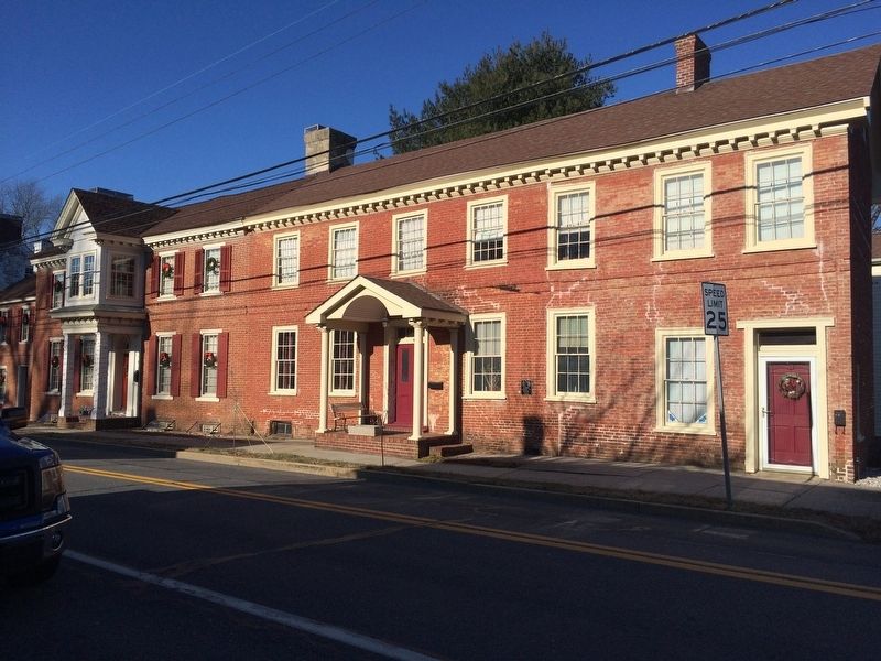
On Fleming Street, 0.1 miles north of Mechanic Street, on the right when traveling north.
This property was
listed in the
National Register
of Historic Places
by the United States
Department of the Interior
on October 8, 2014
— — Map (db m199245) HM
Little Creek United Methodist was established in 1820 as Gum Swamp Methodist Episcopal. By 1832 the church operated and maintained a non-segregated school. In February 1875 the congregation relocated Gum Swamp ME to its current site and on May 30, . . . — — Map (db m141374) HM
Mount Pleasant ME Church formed in 1837 as an outgrowth of local camp meetings. Construction on the simple stone church began in 1838 and a cemetery was established in 1841. In 1893, Mount Pleasant added stained glass windows, a raised pulpit, and . . . — — Map (db m140549) HM
Near Cauffiel Parkway south of Philadelphia Pike (Business U.S. 13), on the left when traveling south.
Once the summer home of a prosperous Wilmington businessman and his family, the Cauffiel House has changed little since it was built in the late 1920s. The colonial style brick house still looks down to the Delaware River over land that was . . . — — Map (db m227941) HM
Near Carr Road south of Bellevue Parkway, on the right when traveling south.
The Bellevue Transformation
After inheriting Bellevue from his father in 1928, William duPont, Jr. transformed the estate to reflect his own passions. DuPont was a man who loved his time on horseback and on the tennis court, and Bellevue . . . — — Map (db m240848) HM
On New Castle Avenue north of Delaware Route 9, on the right when traveling south.
Fort DuPont’s chapel was constructed in 1941 to meet the spiritual needs of soldiers preparing to go abroad. The spire on this chapel indicates its non-denominational status.
The Army considered wooden structures “temporary.” Most of the wooden . . . — — Map (db m156151) HM
James Boulden the Elder and his family moved to Delaware from Maryland in the mid-18th century, amassing wealth and expanding their land ownership in Pencader Hundred as the century progressed. The two-story brick mansion house was built during this . . . — — Map (db m147803) HM
On Colonel Clayton Drive, 0.1 miles north of Ernest Drive, on the left when traveling north.
Choptank
Upon-the-Hill
Est. 1826
has been placed on the
National Register
of Historic Places
by the United States
Department of the Interior
— — Map (db m189386) HM
On West Main Street (Delaware Route 299) just east of North Cass Street, on the right when traveling east.
Forest Presbyterian
Church
44 West Main Street
has been placed on the
National Register
of Historic Places
by the United States
Department of the Interior
1850 — — Map (db m174529) HM
On West Main Street (Delaware Route 299) west of S. Broad Street (Delaware Route 71), on the right when traveling east.
David Witherspoon, born in Ireland, built this tavern in 1761 as a midpoint between waterways to the east and west. While traveling to the Continental Congress, Thomas Jefferson lodged here on June 20, 1775. George Washington also dined at the . . . — — Map (db m155564) HM
Former owners of the Read House, their home for fifty-five years. They were longtime benefactors of New Castle doing much to encourage and promote the preservation and architectural beauty of this colonial town. — — Map (db m54697) HM
On Delaware Street (Delaware Route 273) just west of West 9th Street, on the left when traveling west.
The first house constructed by Guido DeAscanis in 1932. Guido was born in San Omero, Italy in 1900 and arrived in America on July 4, 1920. He founded Guido DeAscanis & Sons, Inc. in 1933. They went on to build many homes and buildings to enhance the . . . — — Map (db m174446) HM
On The Green north of East Park Place, on the right when traveling south.
Emalea Pusey Warner was one of the most influential women in the history of the University of Delaware. She was the first woman appointed to its Board of Trustees, serving from 1928-42.
The project closest to Mrs. Warner's heart was the . . . — — Map (db m131148) HM
On The Green north of East Delaware Avenue (Delaware Route 273), on the left when traveling north.
During the height of the Great Depression, Harry Fletcher Brown first came to the aid of the University of Delaware and, over the next decade, became one of the University's most generous benefactors, financing construction of Brown Laboratory, . . . — — Map (db m154179) HM
On The Green north of East Delaware Avenue (Delaware Route 273), on the right when traveling north.
Born in Sussex County, Del., Hugh Rodney Sharp spent four happy years at Delaware College, now the University of Delaware, graduating in 1900 at the age of 20. He went on to become a successful business executive, a University Trustee and one of . . . — — Map (db m152661) HM
On The Green south of East Delaware Avenue (Delaware Route 273), on the left.
H. Rodney Sharp was only 16 when he entered Delaware College in 1896, and he graduated four years later in what was termed the "Class of aughty-aught." In 1915, he was appointed a Trustee.
Mr. Sharp was deeply loyal to his alma mater. He . . . — — Map (db m152662) HM
Near East Main Street (Delaware Route 273) east of North College Avenue, on the right when traveling west.
Jastak-Burgess Hall, home of the Department of Foreign Languages and Literatures, is named in honor of psychologist Dr. Sarah Jastak-Burgess and Leslie M. Burgess ('43 B.S. UC Berkeley, '61 MBA Harvard). Their generous gifts in support of this . . . — — Map (db m154608) HM
On The Green north of East Park Place, on the left when traveling south.
Kent Residence Hall, constructed in 1956, is named after Kent County, located in the central part of Delaware and home of the First State's capital city of Dover.
The adjoining Kent Dining Hall predates the residence hall by 31 years. The . . . — — Map (db m154027) HM
On Kirkwood Highway (Delaware Route 2) at Old Possum Park Road, on the right when traveling west on Kirkwood Highway.
In the late 18th century a paper mill was established by Thomas Meeteer on the banks of nearby White Clay Creek. In later years Thomas was succeeded in business by his sons Samuel and William. the property on which this house stands was purchased by . . . — — Map (db m154972) HM
Near South College Avenue at James F. Hall Trail, on the right when traveling north.
Designed by architect and engineer S.T. Fuller, the Newark Passenger Railroad Station was built in 1877 at a cost of over $9,000.00 by the Philadelphia, Wilmington and Baltimore Railroad (P. W. & B) to replace an earlier frame building. An . . . — — Map (db m244170) HM
On W. Main Street (Delaware Route 273), on the right when traveling west.
Completed in 1886, this was the home and place of business of Theodore F. Armstrong, a prominent local merchant and civic leader. Reflecting the growing prosperity of the community and its residents, this hybrid of Queen Anne and Gothic architecture . . . — — Map (db m130149) HM
On The Green north of East Park Place when traveling south.
This residence hall is named after Delaware's southernmost county and is one of the oldest buildings on the south Green. Sussex Hall was completed in 1917 and was built with an appropriation from the Delaware General Assembly. It was the second . . . — — Map (db m131152) HM
Near South College Avenue north of Sunset Road, on the right when traveling north.
The beauty of the surrounding landscape on the University's South Green is the result of careful planning in the 1920s by one of the first female landscape architects in the United States, Marian Cruger Coffin. Miss Coffin designed and directed . . . — — Map (db m154197) HM
The University of Delaware traces its origins to a school founded by the Rev. Francis Alison in 1743, which later became the Academy of Newark. In 1833, the state of Delaware chartered its first institute of higher education, called Newark . . . — — Map (db m154335) HM
On The Green south of East Delaware Avenue (Delaware Route 273), on the right when traveling south.
The University of Delaware traces its origins to a school founded by the Rev. Francis Alison in 1743, which later became the Academy of Newark. In 1833, the state of Delaware chartered its first institute of higher education, called Newark . . . — — Map (db m154472) HM
On Market Street (Delaware Route 9) just east of Delaware City Port Penn Road (Delaware Route 9), on the right when traveling west.
Canary-Naudine House & Store
is listed in the
National Register
of Historic Places
by the United States
Department of the Interior
c. 1785
— — Map (db m174828) HM
On North Congress Street just north of Market Street, on the right when traveling north.
Commodore's House
is listed in the
National Register
of Historic Places
by the United States
Department of the Interior
c. 1930
— — Map (db m174842) HM
On South Congress Street just north of Market Street (Delaware Route 9), on the right when traveling south.
Mary Porter Darrach House
is listed in the
National Register
of Historic Places
by the United States
Department of the Interior
c. 1830
— — Map (db m174843) HM
On Market Street (Delaware Route 9) just east of Delaware City Port Penn Road (Delaware Route 9), on the right when traveling east.
Mary Stewart-Cox
House
is listed in the
National Register
of Historic Places
by the United States
Department of the Interior
c. 1792
— — Map (db m174827) HM
On South Congress Street (Route 9) at West Merchant Street, on the right when traveling north on South Congress Street.
O. Webb Double House
is listed in the
National Register
of Historic Places
by the United States
Department of the Interior
c. Mid-19th Century
— — Map (db m174839) HM
On Market Street (Delaware Route 9) at Stewart Street, on the right when traveling east on Market Street.
Port Penn
Presbyterian Church
is listed in the
National Register
of Historic Places
by the United States
Department of the Interior
c. 1856
— — Map (db m174825) HM
On Market Street (Delaware Route 9) just east of Delaware City Port Penn Road (Delaware Route 9), on the left when traveling east.
Samuel Carpenter House
is listed in the
National Register
of Historic Places
by the United States
Department of the Interior
c. Early-19th Century
— — Map (db m174832) HM
On West Merchant Street just east of Stewart Street, on the left when traveling west.
Samuel Kershaw House
is listed in the
National Register
of Historic Places
by the United States
Department of the Interior
c. 1905
— — Map (db m174836) HM
On West Merchant Street just west of South Congress Street (Delaware Route 9), on the left.
Shelby Collins House
is listed in the
National Register
of Historic Places
by the United States
Department of the Interior
c. 1905
— — Map (db m174837) HM
On N. Congress St., 0.1 miles north of Market Street, on the left when traveling north.
This house was ordered by mail and delivered in pieces by railroad to Delaware City and then brought to Port Penn by wagon. Houses could be ordered from Sears, Roebuck and Company, Montgomery Ward, and other sources. During the growth of mass . . . — — Map (db m10391) HM
On Stewart Street just south of Market Street (Delaware Route 9), on the right when traveling south.
The Stewart House built in the mid-1700's, was owned by at least six generations of the family. David Stewart, Sr., credited with founding Port Penn, planned for the town to become a shipping port that could compete with the firmly established . . . — — Map (db m10392) HM
On Market Street (Route 9) just west of Stewart Street, on the right when traveling west.
Thomas Cleaver House
is listed in the
National Register
of Historic Places
by the United States
Department of the Interior
c. Mid-19th Century
— — Map (db m174833) HM
On South Congress Street (Delaware Route 9) just north of West Merchant Street, on the right when traveling south.
Thomas Price House
is listed in the
National Register
of Historic Places
by the United States
Department of the Interior
c. Mid-19th Century
— — Map (db m174838) HM
On South Congress Street (Delaware Route 9) south of Market Street (Delaware Route 9), on the right when traveling south.
W.H. Miller House
is listed in the
National Register
of Historic Places
by the United States
Department of the Interior
c. Late-19th Century
— — Map (db m174840) HM
On South Congress Street (Delaware Route 9) just south of Market Street (Delaware Route 9), on the right when traveling south.
W.H. Miller Rental Property
is listed in the
National Register
of Historic Places
by the United States
Department of the Interior
c. Mid-19th Century
— — Map (db m174841) HM
On Market Street (Delaware Route 9) just east of Delaware City Port Penn Road (Delaware Route 9), on the left when traveling west.
Webb-Jefferson
House
is listed in the
National Register
of Historic Places
by the United States
Department of the Interior
c. 1830-1850 — — Map (db m174831) HM
Near Washington Boulevard, 0.2 miles south of Shipley Road.
Rockwood Mansion was completed in 1854 as the retirement home of Wilmington native Joseph Shipley. Shipley amassed his fortune as a merchant banker while living in Liverpool, England. Joseph Shipley hired Liverpool architect George Williams to . . . — — Map (db m13612) HM
On Old Limestone Road, on the left when traveling north.
A stone on the facade inscribed with the initials "I.M" and a date of "1789" suggests that construction of this dwelling occurred during the late 18th and early 19th centuries, a period of early industrialization in Delaware. Evidence of a stone . . . — — Map (db m145726) HM
Near North Park Drive, 0.1 miles east of North Van Buren Street, on the right when traveling east.
Demand for fur coats pushed many wild cats to the brink of extinction. Thanks to protective legislation, species like bobcats are rebounding.
Brandywine Zoo animal keepers train this bobcat and other zoo animals to voluntarily get in . . . — — Map (db m191218) HM
On North Park Drive north of North Van Buren Street, on the right when traveling south.
The 2001-2002 renovation of the Jasper Crane Rose Garden restored the original stone path and bed layout and removed elements that had been added during the 1960s and 1970s.
This garden is formal and symmetrical in layout and is . . . — — Map (db m216030) HM
On Baynard Boulevard north of Washington Street. Reported permanently removed.
The Sugar Bowl, used as a band shell and observatory, stood at the original entrance to the Brandywine Zoo in the early 1900's. The pavilion was demolished in two stages--its dome was taken down in 1949 and the railings were removed in 1959. . . . — — Map (db m65718) HM
On North Park Drive at North Van Buren Street, on the right when traveling east on North Park Drive.
The Josephine Fountain has been drawing visitors to Brandywine Park since the 1930s. The fountain was built in honor of Mrs. Josephine Tatnall Smith who enjoyed walking through the park. Here families and couples enjoy a cool spring day in the . . . — — Map (db m131170) HM
On Delaware Avenue (Delaware Route 52) at Jackson Street, on the left when traveling west on Delaware Avenue.
Plans for this colonial revival-style structure were drawn by Philadelphia architect Minerva Parker Nichols, one of the first female architects in the United States. Construction of the building, which features eclectic components as well as the . . . — — Map (db m128081) HM
On Kentmere Parkway at N. Union Street on Kentmere Parkway.
This 14.7-acre strip of land, connecting Rockford Park and Grove with Brandywine Park, was designed by famed American landscape architect Frederick Law Olmstead. The land was donated by two Wilmington businessmen, William M. Fields and William Poole . . . — — Map (db m13578) HM
Near Lookout Drive, 0.1 miles west of Tower Drive, on the right when traveling west.
In 1895, Theodore Leisen, engineer for the Wilmington Board of Park Commissioners, recommended that "a large pavilion and observatory" be built in Rockford Park on what was called Mt. Salem Hill, the highest point in the city at 330 feet above sea . . . — — Map (db m13590) HM
On East 11th Street (Delaware Route 52) west of North King Street (Business U.S. 13), on the left when traveling east.
Constructed in 1937 on the site of the McComb Winchester Mansion, this building was placed on the National Register of Historic Places in 1978 as an outstanding example of neoclassical architecture. The building housed the U.S. Post Office and . . . — — Map (db m216009) HM
On Washington Street just north of West 14th Street, on the right when traveling north.
Dedicated to the "Sons of Delaware who joined forces of their country in the Great War" on Memorial Day, 1922.
The monument is presented in architectural detail and messages in bronze
[Captions:]
40' tall monumental pylon in . . . — — Map (db m240744) HM
Washington Street
Bridge Commission
Created by
the General Assembly of the
State of Delaware
March 31, 1919
Alfred I. Dupont, Chairman •
Benjamin F. Shaw •
Isaac Elliott •
John S. Rossell • . . . — — Map (db m240912) HM WM
Near North Church Street (U.S. 13) at East 7th Street, on the right when traveling north.
Originally it was one room with fireplace down stairs and a large bedroom above. The Hendricksons raised eight children in this house. It was enlarged later, and served as home to five generations of Hendricksons.
After many years of . . . — — Map (db m174858) HM
Near North Church Street (U.S. 13) at East 7th Street, on the right when traveling north.
By 1750 the heavy roof had begun to force the thick walls apart, most noticeably on the north side, and much earlier than on the south side (see mark #14). Four stone "buttresses" were built to counter this effect. Years later, these open porticos . . . — — Map (db m174914) HM
Near North Church Street (Route 13) at East 7th Street, on the right when traveling north.
Upon arrival from Sweden in 1697, Pastor Eric Björk began his quest to build a stone church to replace the decaying log structure on the south bank of the Christina River that had served the Swedish Lutheran congregation. Helga Trefaldighet . . . — — Map (db m174436) HM
On West 6th Street east of Washington Street, on the left when traveling east.
This property
407 West 6th Street
has been placed on the
National Register
of Historic Places
by the United States
Department of the Interior — — Map (db m217942) HM
On French Street south of East Front Street, on the right when traveling south.
Designed by Furness, Evans & Company
Opened by the Pennsylvania Railroad Company
January 28, 1907
Station renovated 2009 - 2011
and
Rededicated March 19, 2011 — — Map (db m215945) HM
Near Rosa Parks Drive east of South Market Street (Business U.S. 13), on the right when traveling east.
In the latter half of the nineteenth century, rapid growth of the economy and demand for shipping and passenger service created a boom in railroads. Great fortunes were made which led to battles for control and consolidation of railroad lines. The . . . — — Map (db m184905) HM
Completed in 1905
Pennsylvania Railroad, Owner
Furness and Evans, Architects
Restored in 1984
under the Northeast Corridor Improvement Project — — Map (db m240826) HM
Near Washington Street Extension at Shipley Road, on the left when traveling north.
Built in 1855, this house is called the Gardener's Cottage, because Joseph Shipley's English gardener Robert Salisbury was its first tenant. Shipley brought Salisbury to Rockwood to help him develop the gardens. Baltimore architects Thomas and James . . . — — Map (db m191251) HM
Near Washington Street Extension at Shipley Road, on the left when traveling north.
Joseph Shipley chose this property because the natural rock formations provided the perfect setting for a picturesque landscape. On this land, which he named "Rockwood," Shipley recreated an English country estate and its gardens based on the . . . — — Map (db m191253) HM
Near Washington Street Extension at Shipley Road, on the left when traveling north.
A ha-ha is a sunken wall often used on English estates instead of a fence because it allows for uninterrupted views of the meadows while keeping out livestock. Such views at Rockwood are best appreciated on the veranda, from where the lawns appear . . . — — Map (db m191264) HM
Near Washington Street Extension at Shipley Road, on the left when traveling north.
Stone walls separated the kitchen garden from the rest of the property and provided a protected space to grow fruits and vegetables. Joseph Shipley hand both a hothouse for exotic plants and a cold house for his prize-winning grapes. The stone . . . — — Map (db m191252) HM
Near Washington Street Extension at Shipley Road, on the left when traveling north.
Joseph Shipley built Rockwood between 1851 and 1854. A Wilmington native, Shipley amassed his fortune as a merchant and banker in Liverpool, England. In 1851 he retired to Wilmington and hired Liverpool architect George Williams to design a house . . . — — Map (db m191254) HM
Near Washington Street Extension at Shipley Road, on the left when traveling north.
Visitors coming to Rockwood entered the property through a gate by this lodge, where the gatekeeper lived. Baltimore architects Thomas and James Dixon designed the building in 1855. The building's style and materials introduced to visitors to Joseph . . . — — Map (db m191250) HM
On Delaware Avenue just east of West 14th Street, on the right when traveling west.
This property
1313 Delaware Avenue
has been placed on the
National Register
of Historic Places
by the United States
Department of the Interior — — Map (db m173770) HM
On Delaware Avenue just west of 14th Street, on the right when traveling west.
This property
1315 Delaware Avenue
has been placed on the
National Register
of Historic Places
by the United States
Department of the Interior — — Map (db m173844) HM
On Shallcross Street at Rodney Street on Shallcross Street.
The Frank E. Schoonover Studios were constructed in 1905 by Wilmington philanthropist Samuel Bancroft, Jr. Plans were provided by architect E.L. Rice, incorporating a Queen Anne design with four contiguous units. The original occupants were Frank E. . . . — — Map (db m173772) HM
On Delaware Avenue just west of West 14th Street, on the left when traveling west.
On May 30, 1868, Wilmington residents placed flowers at the graves of Civil War soldiers in response to Gen. John A. Logan's General Order 11, which called for a national day of remembrance. Honoring the sacrifices of those who died in the Civil War . . . — — Map (db m153957) HM
On Kennett Pike (Delaware Route 52) at Hopeton Road, on the right when traveling north on Kennett Pike.
The oldest portion of this structure was erected in 1893 to replace two smaller schools that were no longer adequate to serve the needs of local students. This building was constructed largely through the efforts of the duPont family, long-time . . . — — Map (db m145425) HM
Built in 1961 in a former horse pasture, Winterthur's Visitor Center was designed by architects Victorine and Samuel Homsey to harmonize with the nearby woodlands. Its low roof and glass-walled design allow unobstructed views of the surrounding . . . — — Map (db m184894) HM
On 1st Street just west of Atlantic Avenue, on the right when traveling west.
Built in 1903 by William R. Errett, Pittsburgh, PA, one of the "Six First Families." Its original design has been maintained and is the only one of the first cottages still in the same family. — — Map (db m150144) HM
Bethel's recorded history began in 1683 as a land grant called Manlove's Grove. Kendal Lewis purchased portions of three land tracts. Manlove's Grove. Mitchell's Harbor and Job's lot, from George Mitchell in 1795 and named it Lewis' Wharf. A small . . . — — Map (db m245051) HM
On Main Street, on the right when traveling north.
Named in honor of notable Delawarean. John M. Clayton, the Clayton Theatre was first owned and operated by Alvin "Sheet" Campbell and wife Marjorie, with brother-in-law Elwood "Pete" Hancock and wife Marian. Constructed in 1948 by W. Benjamin Dorey, . . . — — Map (db m245582) HM
On Main Street (County Road 54) at Reed Street, on the right when traveling west on Main Street.
After adventurous service as a sea captain during the late 19th and early 20th centuries, Captain Ebe Townsend Chandler returned to his hometown of Frankford and purchased what is now known as the Captain Chandler House in 1918. Built by Captain . . . — — Map (db m190329) HM
On Seashore Highway (Delaware Route 18/404) 0.1 miles east of County Road 522, on the right when traveling east.
Hebron M.P. church is one of nine rural Methodist Protestant Churches founded in Sussex County prior to 1888. It is the only known rural M.P. church in Sussex County to have undergone minimal alteration since its construction. The church exemplifies . . . — — Map (db m199246) HM
On McColleys Chapel Road (County Road 213) just south of Redden Road, on the right when traveling south.
McColley's Chapel was built and dedicated in 1858 as a Methodist Church. Congregation members had previously worshipped in a small house on the opposite side of the road. James Redden, a member of the board of trustees, sold the property to the . . . — — Map (db m190325) HM