On 24 N Section Street at Fairhope Avenue, on the right when traveling north on 24 N Section Street.
Dedicated 2008
A gift to the people of Fairhope from
The Fairhope Single Tax Corporation
& the City of Fairhope
Dedicated April 5, 2008
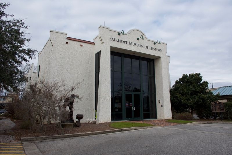
The Front Section of this structure was carefully restored to reflect its original
use as Fairhope's . . . — — Map (db m128887) HM
On Franklin Street, 0.1 miles Washington Street, on the left when traveling north.
Courts met under "Jury Oak"
early 1800s. Judge presided
while sitting on tree limb.
Public executions held
at nearby "hanging tree". — — Map (db m221963) HM
Near Gurnee Avenue south of West 11th Street, on the left when traveling south.
Pursuit: 1:25 p.m. - 1:35 p.m.
Heading to Birmingham, the battered bus turned south on Gurnee from the station and west on 10th St. while men rushed to their cars to follow. Police escorted the bus to the city limits where they turned back, . . . — — Map (db m217416) HM
Near Gurnee Avenue south of West 11th Street, on the left when traveling south.
Rescue
Once there, all of the injured were treated at the urging of an FBI agent on the scene. In the meantime, the crowd outside the hospital grew larger and more menacing, with some Klansmen threatening to burn the building to the ground. At . . . — — Map (db m217420) HM
Near Gurnee Avenue south of West 11th Street, on the left when traveling south.
The Ambush: 12:54 p.m. - 1:10 p.m.
The silence didn't last long. Anniston Klansman William Chappell and a screaming mob of about 50 white men surrounded the bus. An 18-year-old Klansman, Roger Couch, lay on the pavement in front of the bus to . . . — — Map (db m217413) HM
Near Gurnee Avenue south of West 11th Street, on the left when traveling south.
While the Riders awaited rescue, the bus continued to burn. The Anniston Fire Department extinguished the flames and administered oxygen. A state trooper called an ambulance, but it took Cowling to force the driver to carry the injured black Riders . . . — — Map (db m217419) HM
Near Gurnee Avenue south of West 11th Street, on the left when traveling south.
But the Ride didn't end. The national newspaper and television coverage of what had happened galvanized the Nashville Student Movement, which already had experience successfully challenging segregationist practices through lunch counter sit-ins, . . . — — Map (db m217421) HM
On Noble Street at East 12th Street, on the right when traveling north on Noble Street.
This property
has been placed on the
National Register
of Historic Places
by the United States
Department of the Interior
United States Federal Building - Courthouse
Built 1906 — — Map (db m217266) HM
On County Road 388 at County Road 267, on the right when traveling west on County Road 388.
Pat Garrett and Billy the Kid
As sheriff of Lincoln County, Pat Garrett was charged with tracking down and arresting Billy the Kid, a friend from Garrett's saloon keeping days in Fort Sumner, New Mexico. He was captured in December 1880 . . . — — Map (db m83262) HM
On State Highway 273 at County Road 81, on the left when traveling north on State Highway 273.
David was born 4 of 12 children, served in combat in Vietnam, was wounded and is a highly decorated war veteran. David is a best selling author, a veteran advocate, and State Commander of the American Legion. He is a former college instructor and . . . — — Map (db m114742) HM
On 2nd Avenue North, on the right when traveling west.
Fallen officers of Chilton County, Alabama
This is a memorial to the officers who have dedicated their lives for the citizens of Chilton County.
Clyde W. Gregg 1907-1959
Gerald L Horn 1950-1981
William O. (Bill) Wilson 1934-1984
Richard H. . . . — — Map (db m224708) HM
On North Water Street at West 4th Street, on the left when traveling north on North Water Street.
Born in Tennessee on October 22, 1818, Charles Womble was the son of Amos and Sarah (Jarman) Womble. By 1850, Womble owned a farm near the town of Frankfort, which he helped select as the new seat of government for Franklin County, Alabama. Involved . . . — — Map (db m192076) HM
Lynching in America
Thousands of African Americans were victims of lynching and racial violence in the United States between the Civil War and World War II. The lynching of African Americans during this era was a form of racial terrorism used . . . — — Map (db m132071) HM
On County Road 52 at County Road 293, on the left when traveling west on County Road 52.
Lebanon Courthouse was constructed during the 1840s when Lebanon, the county seat of
DeKalb County, was a thriving community with inns, taverns, and government offices. This building, built for courthouse use, remained in use as a courthouse until . . . — — Map (db m156255) HM
On Jackson Trace Road at Hospital Drive, on the right when traveling south on Jackson Trace Road.
In January 1839, Governor Arthur P. Bagby and the State
Legislature enacted a criminal code authorizing a state penitentiary
system for Alabama. A cornerstone was laid in October 1839 on
property purchased adjacent to the Coosa River in Wetumpka . . . — — Map (db m222614) HM
On North 1st Street at Locust Street, on the right when traveling north on North 1st Street.
Lynching in America.
Thousands of Black people were the victims of lynching and racial violence in the United States between 1877 and 1950. The lynching of African Americans during this era was a form of racial terrorism intended to intimidate . . . — — Map (db m116817) HM
On 2nd Street Southeast at 4th Avenue South (Alabama Route 24), on the left when traveling north on 2nd Street Southeast.
You are standing near the site of “The Calaboose”, Red Bay's only jail until 1949 when the city hall was built.
The Calaboose was a small brick building, approximately 10 feet by 20 feet, built over a small ditch. At that time, . . . — — Map (db m68983) HM
On Tuscaloosa Street (Alabama Route 14) east of Springfield Avenue, on the right when traveling east.
On this site, in January 1971, Thomas Earl Gilmore, Sr. was sworn in as Sheriff of Greene County. He was the first African American Sheriff in the county's history and served three consecutive terms until he retired from local politics.
Gilmore, . . . — — Map (db m203630) HM
On Kirkland Street (Alabama Route 27), on the left when traveling south.
William Irvin Nordan and Lewis Washington Nordan were
brothers and partners in a mercantile business in
Abbeville, Alabama prior to 1901. In 1901, William Irvine and Lewis Washington deeded a "brick store house" in the present location to Charlie . . . — — Map (db m216613) HM
On Eastern Valley Road south of Elrie Boulevard, on the right when traveling south.
Thomas McAdory Owen, son of Dr. William Marmaduke
Owen and Nancy Lucretia McAdory Owen, was born
here on December 15, 1866, at the home of his maternal
grandparents, Thomas and Emily McAdory. A University
of Alabama graduate and lawyer, Owen . . . — — Map (db m215738) HM
On 6th Avenue North west of 19th Street North, on the left when traveling west.
On nightly news programs and in newspapers, the images of Birmingham
children under police attack shocked and sickened the nation. It was the
reaction that “Project C” organizers had hoped for. The "Children's Crusade” revived the Birmingham . . . — — Map (db m187837) HM
Racial Terrorism and Convict Leasing. Thousands of black people were the victims of lynching and racial violence in the United States between 1877 and 1950 Lynching was
a form of racial terrorism that went beyond only hanging, . . . — — Map (db m173372) HM
On 5th Avenue North at 16th Street North, on the right when traveling east on 5th Avenue North.
Built 1924 (remodeled for offices in 1995), 413 16th St. N.
Judge Helen Shores Lee bought this one-story building, a
garage from the U.S. Post Office, in 1995 and turned into a law
center to honor her father, pioneer civil rights lawyer . . . — — Map (db m188192) HM
On 21st Way South south of Highland Avenue, on the right when traveling south.
Congregation Beth-El was founded in 1907 on Birmingham's north side. Its leadership came from Knesseth Israel, the city's Orthodox Jewish congregation. Beth-El was established as a modern. yet traditional congregation. Construction on the synagogue . . . — — Map (db m216067) HM
On Lee Highway (County Route 72) at Houstontown raod (Route 33), on the right when traveling east on Lee Highway.
Jesse James Gang
Canal Payroll Robbery
March 1881
In, 1881, approximately three miles south of here, the U.S. Corps of Engineers was constructing the Muscle Shoals Canal along the north side of the Tennessee River. On March 11, 1881, . . . — — Map (db m99897) HM
On North Jefferson Street north of West Washington Street, on the right when traveling north.
On June 22, 1933, Judge James Horton of Athens set aside the verdict and death sentence of an all-white jury that found Haywood Patterson, an African American, guilty of raping two white women. Patterson was one of nine black youths falsely accused . . . — — Map (db m154195) HM
On South Broad Street, 0.1 miles south of Shawnee Street, on the right when traveling south.
Restoring Justice
Henry Williams, Johnny Williams, Ennis Bell, Theodore Wesley Samuels, Prentiss McCann, and Rayfield Davis all died at the height of the segregation era in Mobile. Mobile's Black community protested each of these deaths at the . . . — — Map (db m188735) HM
On Lake Street west of Hall Street, on the right when traveling west.
Hale Infirmary
On this site for nearly seven decades stood Hale Infirmary. It was
among 25 hospitals in Alabama, and the first in Montgomery, established during the Black Hospital Movement, an effort to overcome
healthcare inequities for . . . — — Map (db m240686) HM
On Ferry Street Northeast south of Cain Street Northeast, on the right when traveling south.
A series of racially charged trials where nine African American males ages 13 to 20 were falsely accused of raping two white women on a freight train in Alabama produced a pair of landmark civil rights decisions by the U.S. Supreme Court in the . . . — — Map (db m154233) HM
On South Railroad Street west of Holland Court, on the right when traveling west.
Built in 1950, Fort Jabe Brassell has served as a hub for military training and arms storage for the local community by the Alabama Army National Guard and the Armory Commission of Alabama. Between July 1954 and January 1955, the Alabama Army . . . — — Map (db m165538) HM
On 11th Avenue (Alabama Route 13) north of 19th Street, on the right when traveling north.
The first 9-1-1 emergency services telephone call
was made from the office of the mayor on
February 16, 1968. Earlier in the year, AT&T,
which had a near monopoly in the telephone
industry at the time, had announced its plans
for launching the . . . — — Map (db m153209) HM
On County Road 63 at County Road 61, on the left when traveling south on County Road 63.
Willis Farris was appointed the first sheriff of Hancock County, Alabama, serving from August 31, 1850 to September 19, 1853. Hancock County was renamed Winston County in 1858. Farris then served another term as sheriff from 1859 until 1865. He was . . . — — Map (db m182872) HM
Ketchikan's notorious Creek Street, early Alaska's most infamous red-light district, still retains traces of the gaudy rouge of a half-century of speakeasies and sporting women. Here the fame of Black Mary, Thelma Baker and Dolly Arthur . . . — — Map (db m182103) HM
The Politics of Prohibition pitted the U. S. Constitution's well-meaning 18th Amendment — which banned the manufacture, sale or transportation of liquor — against the ingenuity of the moonshiners and bootleggers who found ways to satisfy the . . . — — Map (db m182102) HM
On East Toughnut Street at South 3rd Street, on the right when traveling west on East Toughnut Street.
Born in Saginaw, Mich., in 1860, English, a law graduate, moved to Tombstone in 1880. He first worked as a miner, then became a partner in Smith & Goodrich law firm. He also served 3 terms as Cochise County District Attorney.
English's . . . — — Map (db m131100) HM
On The Coronado Trail (U.S. 191 at milepost 164), on the left when traveling north.
Blasted from living rock this jail confined many of the bad men who crowed into the district in the boom days. Local tradition says that the first inmate in 1881 was the miner who built the jail. It was contributed to the town by the Lesinsky . . . — — Map (db m36373) HM
Near North Toole Avenue near East Pennington Street.
Wyatt Earp joined his four brothers in the silver-boom town of Tombstone in 1879 where brother Virgil was deputy U.S. marshal. Wyatt was a sometimes-lawman himself, and hoped to become sheriff of the newly formed Cochise County in 1881. He . . . — — Map (db m28929) HM
On Arizona Route 84 at milepost 181, on the right when traveling west.
James Addison Peralta Reavis was a brazen forger who claimed over 12 million acres of Central Arizona and Western New Mexico as an Old Spanish Land grant. He and his family lived here in royal style until his fraud was exposed. From the barony he . . . — — Map (db m27209) HM
On North Main Street north of 12th Street, on the left when traveling north.
Built in 1948, this Contemporary Pueblo Revival building initially housed all town government administration and the Town Council chambers. The Town had a mayor and council-commissioner form of government. With limited staff, each Councilmember was . . . — — Map (db m195851) HM
All water for the prison came from the river. Inmates dug a network of tunnels at the base of the hill which would fill with river water. From there water was pumped up into the 85,000 gallon granite-walled tank, also of inmate construction. In . . . — — Map (db m185955) HM
Near Prison Hill Road, 0.5 miles north of Harold C. Giss Parkway.
In 1904 an incorrigible ward, consisting of five steel cages, was constructed on this site. The total budget for the building, including steel cages, corrugated iron roofing and lumber, was five hundred dollars. Approximately 4,000 adobe bricks, . . . — — Map (db m158296) HM
Near Prison Hill Road, 0.5 miles north of Harold C. Giss Parkway.
The main cellblock was built to house up to 204 prisoners, but at times the Superintendent's report stated that up to 240 prisoners were kept here. Each cell was approximately 9 foot X 12 foot and could hold six prisoners. When space became limited, . . . — — Map (db m158292) HM
The "New Yard" was constructed in 1900 to help relieve overcrowding. The entrance to the library was closed and the first four cells were made from the library excavation in the south bank. Eight more cells were dug into the east side of the same . . . — — Map (db m185959) HM
Near Prison Hill Road, 0.5 miles north of Harold C. Giss Parkway.
Anything a prisoner could not make himself or barter for, he had to do without. As an inmate, forty-eight hours a week were spent working in the fields, quarry, adobe yard, or on assignment in a shop. Whether you needed a tin cup or a new . . . — — Map (db m158293) HM
On Prison Hill Road west of South Levee Road, on the right when traveling south.
The concrete slabs in front of you were the floors of the shop buildings constructed in 1895. The shops housed the electric generating plant, shoe/ tailor shops and the laundry/bathhouse. The 33 foot x 100 foot adobe building had a corrugated iron . . . — — Map (db m191835) HM
• Cast in 1875
• Stands approximately 3 feet high
• Weighs approximately 800 lbs. with carriage
This bell was cast by W.T. Garratt's Brass and Bell Foundry in San Francisco, California in 1875. A sailing ship brought the bell up the . . . — — Map (db m185957) HM
Near Prison Hill Road, 0.5 miles north of Harold C. Giss Parkway.
Yuma of the 1870's had limited marketplaces. Goods were brought in by steamships or many days' journey through hostile country. Calamities along the journey claimed belongings and supplies more than once. The government compensated by stocking as . . . — — Map (db m158298) HM
Near Prison Hill Road, 0.5 miles north of Harold C. Giss Parkway.
The concrete slabs before you are all that remain of an early adobe structure. Originally, this building was where prisoners were processed, ate meals, and received medical attention. Later it housed offices, storerooms, barbershop and the two cells . . . — — Map (db m158297) HM
On Jackson Street south of Johnson Avenue, on the right when traveling south. Reported missing.
Location: West of the railroad tracks on Lincoln Street between McClure & Monroe, almost directly across from Allen Canning Company Warehouse. It was about 12' x 12', made of native stone, cemented together. One small window on the north side was . . . — — Map (db m93282) HM
On Jackson Street south of McClure Avenue (County Road 923), on the right when traveling south.
Location: West of the railroad tracks on Lincoln Street between McClure & Monroe, almost directly across from Allen Canning Company Warehouse.
It was about 12' x 12', made of native stone, cemented together. One small window on the north side was . . . — — Map (db m224840) HM
This fourth County Jail building was originally a two-story brick framed structure. Some of its hardware and cell materials were used in the construction of the 1911 jail built west of the courthouse. Abandoned and vacant from 1919, it was purchased . . . — — Map (db m234418) HM
On Central Avenue (Arkansas Route 7) at Fountain Street when traveling north on Central Avenue.
The old Arlington Hotel, located across the
street on the Arlington Lawn, was the site of
the infamous arrest of New York Giants manager
John “Mugsy” McGraw. Apprehended by a
U.S. Marshal for unlawful gambling when he
was caught pitching silver . . . — — Map (db m211044) HM
On Reserve Street at Central Avenue (Arkansas Route 7), on the left when traveling east on Reserve Street.
On March 12, 1927 U.S. Park Ranger James Alexander Cary was killed by bootleggers while patrolling on West Mountain in Hot Springs National Park.
Cary was the first National Park Service Ranger to be murdered in the line of duty.
His service . . . — — Map (db m211011) HM
On East Main Street at Broad Street, on the left when traveling west on East Main Street.
This site has been the location of three Independence
County courthouses. The first, built in 1857, was
destroyed by fire in the 1880's and replaced by a
Gothic style structure. Batesville's finest example of
Art Deco style building . . . — — Map (db m221135) HM
Near State Road 25, on the right when traveling east.
In 1897, county officials ordered that the jail be remodeled.
The wood floor was replaced with cement. Hammocks
replaced straw bedding. Sewer lines, water closets and
wash basins were installed.
Bunks
4 hammocks, to be 28 . . . — — Map (db m242657) HM
Near State Highway 25, on the right when traveling east.
You are facing the Powhatan Jail
Designed by John D. Edwards, this is a rare example
of a stone military blockhouse.
Lawrence County, is known as the "Mother of Counties". In 1815,
Lawrence County formed this northern region of . . . — — Map (db m242636) HM
On State Highway 25 just west of 3rd Street, on the right when traveling east.
The Powhatan jail housed prisoners for 57 years. Due to increasing security problems, the jail closed in the 1920s A new jail at Walnut Ridge replaced this one after World War 1.
From 1850 an 1935 this building was a canning kitchen. From . . . — — Map (db m242656) HM
On Greenlawn Street (U.S. 371) at De Ann Street, on the left when traveling west on Greenlawn Street.
Thomas Chipman McRae, born in Mount Holly (Union County), Arkansas, became a courier for the Confederate Army at age twelve, following his father's early death. He attended area schools and later graduated from Washington & Lee University law . . . — — Map (db m184504) HM
On West 12th Street at Westpark Drive, on the right when traveling west on West 12th Street.
Lynching in America
Racial terror lynching between 1877 and 1950 claimed the lives of
thousands of African Americans and created a legacy of injustice
that can still be felt today. Following the Civil War and the premature
end of . . . — — Map (db m211279) HM
On Garrison Ave (U.S. 64), on the left when traveling west.
This statue was erected in 2012 as a result of growing awareness of the extraordinary service of Bass Reeves, an African-American former slave who became a highly respected Deputy U.S. Marshal. The deeds of African-American and Native American . . . — — Map (db m58047) HM
After the U.S. Army closed Fort Smith in 1871, the guardhouse served the Federal Court for the Western District of Arkansas. It remained in use as a jail, detaining primarily women suspected or convicted of federal crimes until 1888. At that time, . . . — — Map (db m58128) HM
On West Maple Street at Garland Avenue, on the right when traveling east on West Maple Street.
The nation's 42nd president, William J. Clinton (1993-2001), and First Lady, Hillary Rodham Clinton, were faculty members of the University of Arkansas School of Law in the mid-1970s. Mr. Clinton started in 1973, teaching trade regulation, . . . — — Map (db m224737) HM
On Dunn Avenue south of West 11th Street, on the right when traveling south.
Lynching in America
Before the Civil War, millions of African people were kidnapped, enslaved, and shipped across the Atlantic to the Americas under horrific conditions that frequently resulted in starvation and death. Over two centuries, the . . . — — Map (db m224104) HM
On West Maple Street east of Garland Avenue, on the right when traveling east.
Dr. Robert A. Leflar (1901-97) of the University of Arkansas School of Law was one of the nation's leading scholars in the field of conflict of laws. He taught at the School of Law for more than 60 years, and directed the appellate judges seminars . . . — — Map (db m224734) HM
On East Main Street at North Church Street, on the left when traveling west on East Main Street.
City Council
Michael C. Bohl, Mayor • Bobbie Potts, Mayor Pro Tem • Gary Beck, Councilman • Jim Brazil, Councilman • Loreta Tillery, Councilwoman
Staff
Randy L. Johnsen, City Administrator • Janic Traverso, City Clerk • Guy Reynolds, . . . — — Map (db m2376) HM
The “castle,” built in 1890–1894, is the most significant example of Romanesque Revival architecture in the Mother Lode. It was built to house the Preston School of Industry, established by the State Legislature as a progressive . . . — — Map (db m100594) HM
On Black Bart Road at Sandra Lane on Black Bart Road.
Attacked La Port [sic] – Oroville stage here, July 13, 1888. Frank N. Morse, driver, was repulsed by George Hackett, armed messenger for Wells Fargo Express. Twenty eight stage hold-ups in California 1875-1883 are credited to Black . . . — — Map (db m134505) HM
On Oroville Dam Boulevard West, on the left when traveling west.
It is not how this officer died that makes him a hero, it is how he lived.
Deputy Sheriff Randal Eugene Jennings
Badge No. 80
Butte County Sheriff’s Office
On May 21, 1997 Deputy Randy Jennings became the first Butte County Sheriff’s . . . — — Map (db m65841) HM
On South Algiers Street, on the right when traveling east.
The Myrphys Pokey was built around 1915 by Tom Burrow, Frank Kaler, Price Williams, Frank Segale and Frank Forrester and is constructed of hand-mixed concrete. The previous jail was made of wood and was located closer to the creek.
It is doubted . . . — — Map (db m229243) HM
Near Mount Diablo Boulevard west of Mt Diablo Court when traveling south.
First sheriff of Contra Costa County 1850-1852 which then also included portion of Alameda County
This tablet donated by Sheriff John A Miller of Contra Costa County and Sheriff M.B. Driver of Alameda County and placed by Native Sons of the . . . — — Map (db m216832) HM
Near State Highway 49. Reported permanently removed.
Coloma’s first jail was made of logs and was located around the corner on High Street. The second jail, built in 1855, quickly proved to be too small, and this stone-block prison was erected. It was used from 1857 until 1862. The metal cell that . . . — — Map (db m12228) HM
On Coloma Road (California Route 49) south of Mt Murphy Road, on the right when traveling south.
In the 1850s, the law offices of Thomas Robertson and the firm of Sanderson and Hews were at this site. The town alcalde also had his office here. Borrowed from Mexican government, the position of alcalde combined the roles of mayor, justice of the . . . — — Map (db m17572) HM
On Thursday, June 30, 1864 at about 10 PM two west-bound stage coaches of the Pioneer Stage Company were held up and the passengers robbed at gun-point at a location approximately 15 miles east of Placerville.
The bandits demanded and obtained . . . — — Map (db m13150) HM
Re-Dedicated July 1, 1986
To The Memory of
Joseph M. Staples
El Dorado County Deputy Sheriff
Who Was Killed In The Line
Of Duty July 1, 1864 — — Map (db m13970) HM
On Pony Express Trail, on the left when traveling east.
Scene of the robbery of two coaches of the Pioneer Stage Line running between Virginia City, Nevada, and Sacramento, California, on the night of June 30, 1864, at about ten o’clock. Perpetrated by a gang of fourteen men, eight sacks of bullion and . . . — — Map (db m13922) HM
On West Pelco Way at West Pontiac Way on West Pelco Way.
In Memory of the victims of September 11, 2001 and in honor of our fallen heroes
America's bravest - New York City Firefighters
Port Authority of NY and NY Police Officers
America's Finest - New York City Police Officers
The Passengers . . . — — Map (db m114526) WM
On California Route 33, 0.1 miles south of Dorris Road (California Route 198), on the left when traveling south.
Headquarters of notorious bandit Joaquin Murieta. Killed here July 25, 1853 by posse of state rangers led by Captain Harry Love. Terrorized mining camps and stage operations during his career. — — Map (db m151585) HM
On Dorris Avenue (State Highway 198) 0.1 miles east of State Highway 33, on the left when traveling east.
Headquarters of notorious bandit, Joaquin Murieta. Killed here July 25, 1853, by posse of State Rangers, led by Captain Harry Love. Terrorized mining camps and stage operations during his career. — — Map (db m229467) HM
Near Draper Street, on the right when traveling north.
On the night of November 2, 1916, Fred French, while performing his duties of deputy night watchman for the community of Kingsburg, encountered Lew Cowan behaving in a drunken and disorderly manner in the pool hall. Cowan and French engaged in a . . . — — Map (db m95379) HM
Near Draper Street, on the right when traveling north.
Constable George Boyle died of gunshot wounds on November 18, 1924, after being shot four times in a gun battle with three fugitives. According to the Kingsburg Recorder, Boyle was shot four days earlier while attempting to apprehend three convicts . . . — — Map (db m95380) HM
On California Route 45,, 0.7 miles north of Route 28, on the right when traveling north.
Early California pioneer,
member of original
Bear Flag Party
organized June 1846 in Colusi County, since changed to Colusa.
As first and only president of
"California Republic",
issued, on June 18, 1846,
historic proclamation.
Held . . . — — Map (db m172453) HM
On South Main Street (U.S. 395) at Lagoon Street, on the right when traveling south on South Main Street.
The early days of Inyo County presented many challenges to the original settlers, particularly for peacekeepers. The first sheriff, W.A. Greenly, served only one year. Many officials served only one or two years before resigning. Territorial and . . . — — Map (db m200934) HM
Near Coyote Canyon Road, 6.5 miles east of Wingate Road.
Barker Ranch was built by
"recreational ranchers"
who moved to the desert to
enjoy the solitude and simplicity of living far from civilization, Bluch and Helen
Thomason moved to the
area in the late 1930s to try
their hand at gold . . . — — Map (db m238166) HM
On U.S. 395, 0.2 miles south of Red Mountain Road, on the right when traveling south.
Kelly Silver Mine
Silver was discovered directly behind this building around 1918. The Kelly Silver Mine was the richest in the world at the time, albeit other silver mines in the area were very profitable as well. As a result, the . . . — — Map (db m152428) HM
To quote the authors, Frank F. Latta, Arnold R. Rojas, and Bonnie Ketterl Kane, per Rancho El Tejon’s Mayordomo (Supervisor) of almost sixty years, Don Jose Jesus Lopez (J.J.), about Avelino Martinez; “He was a little dried up gnome of a man, . . . — — Map (db m98873) HM
On Iris Way at Violette Court, on the right when traveling north on Iris Way.
“I’m coming to see you Tom”, said James Hayes. “Well, come a’ shooting” Godwin replied ---and he did!
Tom Godwin was a farmer, stock raiser, and owner/manager of the Mountain House bar and restaurant, but he was also the Tehachapi town . . . — — Map (db m232409) HM
In 1933 California’s first women’s prison was established in Tehachapi to provide an environment more conductive to rehabilitation than San Quentin State Prison. Two-story buildings were constructed of reinforced concrete in the French Normandy . . . — — Map (db m134503) HM