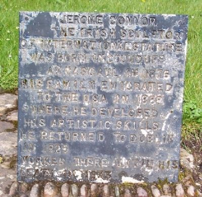
The Irish sculptor of international stature was born in Coumduff, Annascaul in 1876. His family emigrated to the USA in 1888 where he developed his artistic skills. He returned to Dublin in 1925, worked there until his death in 1943.
Among . . . — — Map (db m23075) HM
Expeditions to Antarctica
Discovery, 1901-1904
Terra Nova, 1910-1013
Endurance, 1914-1917
In recognition of his invaluable
contribution to these expeditions
and of his many acts of
selfless heroism on behalf
of his companions . . . — — Map (db m23045) HM
of this Parish
who commanded the
Irish UN Peace Keeping Force
in the Battle of Jadotville
in the Congo in 1961
Officially unveiled
by former Taoiseach
Enda Kenny TD
October 2017 — — Map (db m140707) HM
Taistealaithe oíche
Tá sé seo an cheann de na háiteanna is fearr ar Domhan le bheith ag féachaint ar réaltaí na spéiew an oíche.
Is é[?]an Kerry International Dark Sky Reserve an chéad cheantar sa leathsféar thuaidh ar ar . . . — — Map (db m140708) HM
Bóthar an Ime / Bóthar an Chuinsailéara
Tá aithne forleathan ar an mbóthar seo, a bhí in úsáid san ochtú agus sa luath-naoú chéad déag, faoin dá anim seo. Iompraíodh im ó Chiarraí Theas ar an mbóthar seo go dtí margadh an ime i . . . — — Map (db m140842) HM
Diameter 1.4 million km or 100 Earth diameters
Model Size 76.2 cm
Distance from Earth: 150 million km
or Astronomical Unit (1 AU)
Orbit Period: 27 days
Atmosphere: mostly Helium and Hydrogen
Surface Temperature: 5,500°C
Star Type: . . . — — Map (db m140847) HM
This Marconi Licensed college was founded here in 1911 by Maurice Fitzgerald, formerly of Ballinskelligs Cable Station.
Many wireless and cable operators were trained here, including Republican Volunteer Con Keating of Reenard, Cahersiveen. Con . . . — — Map (db m142388) HM
In the grounds of the O'Connell Memorial Church lies the grave of Monsignor Hugh O'Flaherty.
In Rome during World War II, he bravely organised an elaborate escape network for Allied POW's and civilians. When the l[A]lies entered Rome in 1944, . . . — — Map (db m142356) HM
In 1879 Rev. Timothy Brosnon was appointed Parish Priest of Cahersiveen and as a great admirer of Daniel O'Connell, he hoped to erect a Church that would suitably mark the centenary of his birth in 1775. Having received an audience with Pope Leo . . . — — Map (db m142353) HM
At Carhan Bridge O'Connell's home comes into view on the banks of Carhan River. He was born on August 6th 1775 at Carhan House. His parents were Morgan O'Connell and Catherine Mullane who hailed from North Cork. There were 10 siblings in the . . . — — Map (db m142604) HM
In the early 19th century Daniel O'Connell was very conscious of the need to educate the people of South Kerry and so he bought a rectors lodge in Bank Street. He invited nuns from the Presentation Order to come and set up a school to help . . . — — Map (db m142380) HM
Leaving the town park the trail proceeds to Reenrusheen road. Locally this road is known as Primrose walk. John Primrose was married to a cousin of Daniel O'Connell and he appointed Primrose as his agent in the area. O'Connell was finding it . . . — — Map (db m142474) HM
Early in the 1830's the bringing of the Railway to South Kerry was discussed. O'Connell's idea was to see the railway touching the southern coastline and to continue from Cahersiveen to Cork via Kenmare. The line between Farranfore and Killorglin . . . — — Map (db m142461) HM
Cahersiveen
Cathair saidhbhin
'The fort of Saidhbin (Little Sarah)
Saidhbin was said to be the daughter of McCarthy Mor who held the lands of Iveragh. She was given the fort and the surrounding area, on the banks of the Fertha . . . — — Map (db m142406) HM
Moving away from the Railway Bridge and the River Fertha the town park comes into view. Here was the original site of the fort of Sive which gives its name to the town of Cahersiveen. At one time there was a small village in the vicinity but very . . . — — Map (db m142468) HM
The parish of Caher was once under the instruction of this 17th century Roman Catholic Church. The graveyard around the Church has recently been restored and this peaceful area of Cahersiveen is the resting place of Morgan and Catherine . . . — — Map (db m142683) HM
The Heritage Centre came about following the defeat of the Fenians in 1867. The English government was anxious about the safety of the Valentia Atlantic cable station. A new constabulary barracks was built on the banks of the River Fertha and it . . . — — Map (db m142383) HM
"The town which climbs the mountain and looks upon the sea
in sleeping time or waking that's where I want to be."
Sigerson Clifford 1913-1985
As well as being the birthplace of Daniel O'Connell, Cahersiveen has more connections with . . . — — Map (db m142607) HM
This Parkland was donated to the people of Cahersiveen in 1997 by John (Kitty) O'Sullivan, and the development was undertaken by ACARD Ltd.
Across the Carhan River you can see the ruins of Carhan House, which on 6th August 1775 was the . . . — — Map (db m142681) HM
In 1893 the Killorglin to Valentia branch of The Great Southern and Western Railway opened. The need by local farmers and fishermen to get their produce to market in Britain was identified and the provision of a grant of £85,000, from the British . . . — — Map (db m142419) HM
Tógadh an leacht so
15 cuimhne
oifigeach agus óglach
de'n tríomhadh bhriogaid
ciarraidhe
agus na laoch eile
a fuair bas ar son
poblacht na hÉireann . . . — — Map (db m142806) HM
It was [B]ishop Moynihans wish to build a church in Castle Cove. His reason for building a church here was, as a curate in 1917 he saw first hand the people of Castle Cove walking the long journey to Caherdaniel. When they finally reached . . . — — Map (db m140518) HM
Poblacht na h'Eireann,
The Provisional Government
of the
Irish Republic
to the People of Ireland.
[balance of proclamation not transcribed]
Thomas MacDonagh, Executed 3rd May 1916
Joseph Mary Plunkett, . . . — — Map (db m142791) HM
Tobairin
Our Lady of Grace Coomanaspig
During the 1st Mass on Oct 31st 1994
concelebrated by
Fr. P Sugrue P.P & Fr. E. O'Carroll C.C.
This grotto was opened & blessed
on May 17th 1998 by Bishop of Kerry
Bishop Bill Murphy . . . — — Map (db m141169) HM
Sárstátaire Éireannach
Bhí bá ar leith ag Dónall Uí Chonaill, 'an Fuascailteoir' agus athair ghluaiseacht neamhspleáchais na hÉireann le Doire Fhíonáin. Ba é an stocaireacht a rinne sé ba chúis le hachtú Acht Fhuascailt na . . . — — Map (db m140797) HM
This group, the most westerly off the Irish coast, comprises 7 sizeable islands and isolated rocks spread in a line west by south over 2½ miles of the Atlantic, the largest (Great Blasket) 2 miles off shore.
Antiquities of the early . . . — — Map (db m24096) HM
Dunbeg Promontory Fort
This Promontory Fort consists of four fosses (ditches) and five mounds. Behind this we have the terraced dry-stone masonry rampart, originally straight but which became curved during later construction work. The . . . — — Map (db m24780) HM
Built around the 7th or 8th century this Oratory resembles an inverted boat. This is the only perfect remaining example of a number of small corbel-built Oratories on a rectangular plan. The outward inclination of the bed joints of the stonework . . . — — Map (db m23499) HM
The Great Southern and Western Railway operated a branch line of 39.5 mls. from Farranfore to Valentia Harbour for 67 yrs. The first section of the line, 12.5 mls. opened 15th Jan. 1885. The remaining 27mls. started in 1890; crossing three rivers, . . . — — Map (db m142761) HM
In commemoration of the 150th
anniversary of the Fenian Rising and
the efforts of John Golden and the
South Kerry Fenians
John Golden
1845 - 1883 — — Map (db m142699) HM
Although there had been a settlement of English colonists in Kenmare since 1670 it was not until a century later that the foundations of the present estate town were laid. This was done by William Petty-Fitzmaurice, the 1st Marquis of . . . — — Map (db m139672) HM
HENRY STREET - This street was named in honour of the 3rd Marquis of Lansdowne, Henry Petty-Fitzmaurice (1780-1863), who oversaw a number of major stages in the development of Kenmare. It dates from 1770s but assumed its present form . . . — — Map (db m139847) HM
This pub has been granted the
James Joyce Pub Award
for being an authentic Irish pub
'A good puzzle would be to cross Ireland
without passing a pub.' Ulysses
James Joyce identified and described the . . . — — Map (db m139755) HM
Early History
Stone circles, standing stones and rock art are common around Kenmare. These archaeological sites indicate humans have lived here from the Bronze Age (c.2200-500BC). But it was the upheavals of 17th century Ireland . . . — — Map (db m139761) HM
MAIN STREET - Main Street was formerly named William Street in honour of the 1st Marquis of Lansdowne, William Petty-Fitzmaurice who was raised in Lixnaw, County Kerry. He inherited the Lansdowne estates at Kenmare in 1761 and became . . . — — Map (db m139850) HM
The Market House - This three storey Classical style building was designed by renowned English architect Sir Charles Barry for the 3rd Marquis of Lansdowne. Barry (1795-1860) was a prominent architect of his time. Probably his most . . . — — Map (db m139774) HM
In onóir gaisigh Óglaigh na hÉireann agus laochra
Cumann na mBan a throid ar son Saoirse na hÉireann
a tógadh an leacht chuimhneacháin seo.
Erected in honour of the men of Óglaigh na hÉireann and
the women of Cumann na . . . — — Map (db m139673) HM WM
As part of their preparations for the 1916 Easter Rising, the Irish Republican Brotherhood (IRB) decided on a plan to seize a wireless transmitter from the Atlantic College in Cahersiveen to contact the Aud, the German vessel which carried arms . . . — — Map (db m142785) HM
In commemoration of
the first casualties
of the 1916 Rising
Erected at Easter 2016
—————————————
Mar chomóradh ar na
chéad taismigh . . . — — Map (db m142789) HM
Late Captain Kerry Militia
Drowned in Castlemaine Bay
20th June 1867
when gallantly attempting to
save the life of a fellow creature
Erected
by his brother officers
of the Kerry Militia
in testimony of the affectionate . . . — — Map (db m142765) HM
Kilmalkedar — from Cill Mhaoilchéadair (the Church of Mhaoilchéadair)
Kilmalkedar Church
Kilmalkedar, one of the most important early church sites on the Dingle peninsula, is traditionally associated with St. Brendan but it was . . . — — Map (db m24299) HM
This sculpture was designed by local councillor and craftsman Tony O'Callaghan
The “Standing Stone” illustrates the River Feale which flows around our town.
The “Ring” depicts an earthen fort situated in the . . . — — Map (db m23989) HM
Where very many
nameless victims of the
Irish Famine of 1845-47
lie buried
Also buried here are others
who died
in the nearby workhouse
built 1840
Saibhreas na bhflaitheas dóibh! — — Map (db m23042) HM
POBLACHT NA H EIREANN.
The Provisional Government
of the
Irish Republic
TO THE PEOPLE OF IRELAND.
IRISHMEN AND IRISHWOMEN: In the name of God and of the dead generations
from which she receives bor old tradition Inationhood, . . . — — Map (db m231457) HM WM
The village of Portmagee was named after Captain Theobald Magee who was an officer in King James's Army. After the famous Battle of the Boyne, Magee retired from the army and became the commander of a merchant ship operating between . . . — — Map (db m141308) HM
This boat was built by Dan 'Denny' O'Connell in the early 1900s. He built her at the back of the Post Office, where he built all his boats, on a site which later became the local dance hall. Her purpose was to ferry people from . . . — — Map (db m141205) HM
Poet, fiddler, teacher, and dancing master, born in Derrynane, Co. Kerry, Tomás Rua was a supporter and close friend of the Irish Politician Daniel O'Connell.
Amhrán ne Leabhar - Song of the books.
Tomás Rua was transferred from . . . — — Map (db m141208) HM
Reask - from An Riasc (the marsh). This important early monastery was probably founded in the 6th century.
Little is known of the history of the site. The enclosing wall is roughly circular and its interior is divided by a . . . — — Map (db m24147) HM
Chief Justice of Ireland 1961-1973
Judge of the European Court of Justice 1973-1974
President of Ireland 1974-1976
Unveiled June 5th, 1983
by
The President of Ireland
Dr. Patrick Hillery
Sculptor-Vivienne Roche
I don't . . . — — Map (db m139942) HM
En ce moment grave de ma longue vie,
j'ai trouvé ici ce que je cherchais :
être en face de moi-même.
L'Irlande me l'a offert
de la façon la plus delicate,
la plus amicale.
(18.VI.1969) . . . — — Map (db m139881) HM
One of the 'All-Time Great' Gaelic football stars
and a member of Kerry's 'Golden Era Team'
of the 1970s and 80s. John played for Sneem Gaa club
and following retirement from Kerry,
for Bishopstown in Cork where he worked.
He . . . — — Map (db m139889) HM
[Chinese script not transcribed]
Go maire an Cairdeas idir Pobal na Síne agus na hÉireann go deo. Tiomnaithe d'Iar-Uachtarán na hÉireann, A Oirirceas an tUas. Cearbhall Ó Dálaigh, nach maireann, ag Comhlachas Phobal na Síne um . . . — — Map (db m139934) HM
Gift to the people of Ireland
from the President of Israel,
Chaim Herzog,
in memory of Cearbhall Ó Dálaigh.
Wednesday 19th June, 1985
Sculptor Tamara Rikman
——————————
Ar na bhronnadh ar
mhuintir . . . — — Map (db m139887) HM
Tá sé seo ar cheann de na cathracha is mó agus is breátha in Éirinn agus is dóigh gur i gcéadta luatha d'aois Chríost, sular tháinig an Chríostaíocht go hÉirinn, a tógadh í. Ní foláir nó go raibh taoiseach nó feimeoir . . . — — Map (db m140605) HM
Fear na scannan cara an choireáin
a chaith blianta shona inár measc.
For the man who made the movies
speak in the hearts of millions
Charlie spent many years in our
midst as a welcome and humble
guest and friend of . . . — — Map (db m140959) HM
This is the main entrance to the Cable
Station property. This station operated
6 cables to America, 4 cables to the U.K.
and 2 to France. Together with its sister
companies it relayed cablegrams worldwide.
The company broke the monopoly . . . — — Map (db m141068) HM
Dr. Millerick served this community with great diligence for
11 years from 1887 until his death in 1898 at the age of 33.
He is buried at Abbey Island, Derrynane in the O'Connell family plot.
Derrynane Dispensary Committee . . . — — Map (db m140949) HM
Built in 1858, as a shooting lodge,
by J. Clemanti.
The Commercial Cable Company
purchased the lodge in 1884 for the
superintendent's residence and as
the company's first office.
The office was later enlarged by
an extension . . . — — Map (db m141081) HM
Superintendent's Residence
Take a moment to read the adjacent
commemorative plaque for information
on the heritage of this house.
In addition to the Superintendent's residence the
grounds also included the Bachelor's quarters . . . — — Map (db m141086) HM
Determined in 1892
by
Herbert Hall Turner
and
Henry Park Hollis
Royal Observatory, Greenwich
and
Prof. Clement H. McLeod
McGill . . . — — Map (db m141094) HM
Erected by the Commercial Cable Company in
the 1890's to mark Waterville Cable Station's
participation in the 1892 international project with
Greenwich Observatory and McGill University,
to determine the longitude of . . . — — Map (db m141096) HM
Born
9th June 1936
Birthplace
Waterville, Co. Kerry
Parents
John O'Dwyer and Mary Galvin
Married
Mary Carmel O'Sullivan on 20th Feb 1962
Family
Four sons: John, Michael, Robert and Karl
----------------
Inter-County . . . — — Map (db m140960) HM
This building, designed by renowned Irish architect
J.F. Fuller FSA, housed the offices of the
Commercial Cable Company from 1899 to 1964.
Worldwide telegraphs were received and transmitted
from here. Waterville was one of the . . . — — Map (db m141069) HM