815 entries match your criteria. The first 100 are listed. Next 100 ⊳
Texas 1936 Centennial Markers and Monuments Historical Markers
In 1935/1936 the State of Texas Legislature created a commission to celebrate the 100th anniversary of Texas independence from Mexico. Part of this consisted of placing about 1,100 statues, and granite and bronze markers and monuments around Texas. See more at the Texas Historical Commission website 1936 Texas Centennial Markers.
By James Hulse, April 25, 2024
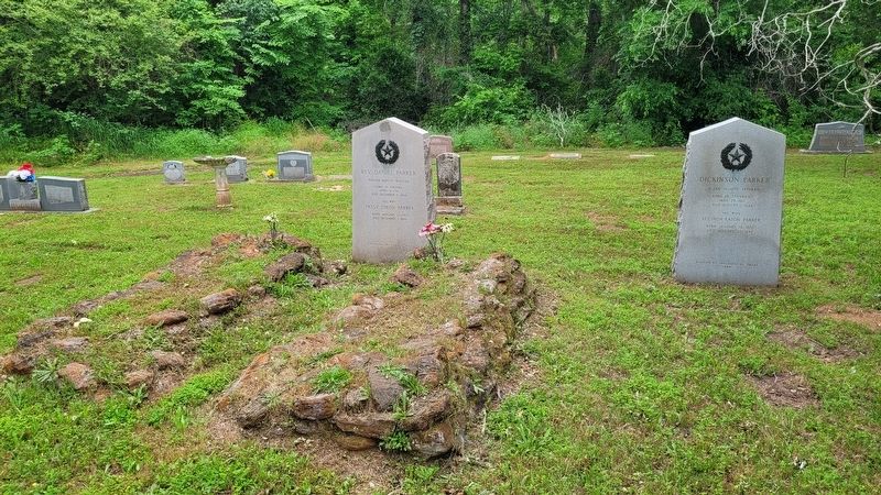
The Dickinson Parker Marker is the second marker on the right side
On Farm to Market Road 861, 0.2 miles north of County Road 103, on the left when traveling north.
A San Jacinto Veteran Born in Tennessee May 29, 1812 Died August 1, 1844
His Wife Lucinda Eaton Parker
Born January 14, 1820 Died January 27, 1847 — — Map (db m245832) WM
On Farm to Market Road 861, 0.2 miles north of County Road 103, on the left when traveling north.
A Soldier in the Army of Texas, 1836
Born in Indiana July 26, 1816 Died November 24, 1849
His Wife Laura Jordon Bennett
Born August 28, 1830 Died December 24, 1925 — — Map (db m245833) WM
On State Highway 294 at Farm to Market Road 319, on the right when traveling east on State Highway 294.
Organized in Illinois in 1833
by Daniel Parker
Members moved to Texas
First meeting in
Stephen F. Austin's Colony
January 20, 1834
Log church built December, 1839
Old graveyard adjoins.
Present church fourth on the same site . . . — — Map (db m36924) HM
On Farm to Market Road 861, 0.2 miles north of County Road 103, on the left when traveling north.
Organized in Illinois, July 26, 1833 by Daniel Parker
Members moved to Texas in a body
arriving November 12, 1833.
First recorded meeting in Texas
was held in Austin's Colony near the present town of Anderson, Grimes County January 20, . . . — — Map (db m245752) HM
On Farm to Market Road 861, 0.2 miles north of County Road 103, on the left when traveling north.
Pioneer Baptist Minister
Born in Virginia
April 6, 1781 Died December 3, 1844
His Wife Patsy Dixon Parker
Born January 17, 1783 Died December 1, 1846 — — Map (db m245830) WM
On Farm to Market Road 19 at Road 320, on the right when traveling south on Road 19.
Here General Thomas J. Rusk with 200 Texans on October 16, 1838, attacked a band of hostile Indians and allied Mexicans, molestors of frontier settlements, and routed them. — — Map (db m102008) HM
On North Mallard Street (State Highway 19) at East Poplar Street, on the right when traveling south on North Mallard Street.
Created March 24, 1846,
from Houston County
Organized July 13, 1846 with
Palestine as the county seat
Named in honor of
Kenneth Lewis Anderson
Vice-President of the
Republic of Texas
1844-45 — — Map (db m128942) HM
On West Reagan Street at Knox Street, on the right when traveling east on West Reagan Street.
A fort and stockade built about 1836 on the public square of the town of Houston (then in Houston County), as a protection against the Indians, by order of General Sam Houston, Commander-in-Chief of the Texan Armies. The town was abandoned in 1846 . . . — — Map (db m182048) HM
On Charlton St. east of Third Street, on the right when traveling east.
Created and organized in 1846. Originally a part of Nacogdoches County. Bears the name of the river traversing the region. The following towns have served as the county seat; Marion,1846-1854; Jonesville,1854-1858; Homer, Feb. 3 - May 17, 1858, when . . . — — Map (db m29862) HM
Near Henderson Street at Fulton Beach Road, on the left when traveling east.
Home of
George W. Fulton
Born at Philadelphia, June 8, 1810
Served in the Texan Army in 1836
A pioneer resident of Refugio County
After an engineering career
of distinction elsewhere,
he returned to Texas and
became a cattle . . . — — Map (db m53700) HM
On State Highway 35 at Farm to Market Road 1781, on the left when traveling north on State Highway 35.
Site of one of the homes of
James Power
Born in Ireland, 1789
Died in Live Oak Point, Texas, 1852
With James Hewetson
he was granted authority
January 11, 1828
to settle 200 families in Texas
Served Texas under three flags as . . . — — Map (db m53708) HM
On Bois D’Arc Street at Main Street, on the right when traveling north on Bois D’Arc Street.
Site of the town of
Lamar
Named for
Mirabeau B. Lamar
1798 – 1859
President of the
Republic of Texas
1838 – 1841
Established in 1838
Made a Port of Entry in 1839
Sacked by Union Troops
Feb. 11, 1864
Survived until . . . — — Map (db m53711) HM
On Broadway Street (State Highway 35) at East Orleans Street, in the median on Broadway Street.
Created September 18, 1871
from Refugio County;
Organized in 1871 with
Rockport as the County Seat.
Named for the River
Nuestra Señora de Aranzazu — — Map (db m53705) HM
On State Highway 79, 0.3 miles north of Sam Cowan Road, on the right when traveling south.
A part of the Peters Grant, 1841
Created January 22, 1858
Organized July 27, 1880
Named in honor of
Dr. Branch Tanner Archer
1790-1856
Texas Commissioner to the
United States, 1835, Member of
Congress, Secretary of War
of . . . — — Map (db m187144) HM
Near County Road 25, 0.2 miles south of U.S. 287, on the right when traveling south.
First ranch in the Texas panhandle
Established in 1876 by
Charles Goodnight
1836- 1929
Noted scout, Indian fighter, trail blazer
and rancher
The Burbank of the range — — Map (db m49328) HM
On Campbell Avenue at Circle Drive, on the left when traveling north on Campbell Avenue.
As early as 1722 El Camino Real (The King's Highway) from the Rio Grande to San Antonio was well established in this area. The Spanish word "Atascosa," denoting boggy ground that hindered travel, gave region its name. The county was created in . . . — — Map (db m201987) HM
On West Main Street (State Highway 36) at Nelsonville Road (State Highway 159), in the median on West Main Street.
A part of the grant to
Stephen F. Austin in 1821
Created a municipality under the
Mexican government in 1828
Became a county of the
Republic of Texas, March 17, 1836
Named in honor of
Stephen Fuller Austin, 1793-1836
Pioneer . . . — — Map (db m125601) HM
Near Amthor Street, 0.1 miles south of East Main Street (Farm to Market Road 529).
A member of the Mier Expedition, 1842
Born in Grantham, England March 30, 1820
Died January 4, 1865
Erected by the State of Texas 1936 — — Map (db m157516) HM
On Schroeder Road, 0.2 miles west of Ernst Parkway (Farm to Market Road 109), on the left when traveling west.
Founded by Friedrich Ernst • Born at Varel, Oldenburg, Germany • Immigrated to America, 1829 and to Texas in 1831 • Died here in 1858 • The Town was laid out in 1838 — — Map (db m165426) HM
On Ernst Parkway (Farm to Market Road 109) at Missouri Street, on the right when traveling south on Ernst Parkway.
First known as Duff's Settlement in honor of James C. Duff to whom the land was granted in 1841 • Settled by Germans after 1845 and renamed in honor of the German city of Ulm — — Map (db m176227) HM
Near Farm to Market 1458, 0.2 miles 2nd Street, on the left when traveling north.
Near this site stood
A Town Hall
Built about 1830
in which were held
the First and Second Conventions
of Texas, 1832 and 1833,
and the Consultation of 1835
the provisional government functioned
here until March 2, 1836, when . . . — — Map (db m43759) HM
On State Highway 16 at Old San Antonio Road, on the right when traveling south on State Highway 16.
A strategic Indian point in early days. Rangers and Comanches struggled here in 1843. In 1854 Elder Lyman Wight settled Mormon colony. In 1855 Poles settled here. From early days a part of Bexar County, created and organized in 1856
Bandera, . . . — — Map (db m117676) HM
On Hwy 173, 10.6 miles north of SR 16, on the left when traveling north.
Celebrated Indian pass known from the earliest days of Spanish settlement · Identified with many a frontier fight and many a hostile inroad · Old ranger trail from the Medina to the Guadalupe River and the United States Army route between frontier . . . — — Map (db m24384) HM
On State Highway 21 at Loop State Highway 150, on the right when traveling east on State Highway 21.
A part of Austin's grant in 1821 created the municipality of Mina 1834, became the County of Mina in the Republic of Texas 1836 Name changed to "Bastrop" December 18, 1837, in honor of Felipe Enrique Neri Baron de Bastrop, 1770-1829 land . . . — — Map (db m118740) HM
On Pecan Street north of Walnut Street, on the right when traveling south.
Chosen commissary by
General Andrew Jackson, War of 1812
Edward Burleson, his son,
accompanied him as book-keeper
Participated in
the Battle of New Orleans
January 8, 1815
Served under
his son, Edward, Army of Texas,
in the Grass . . . — — Map (db m111111) HM
On Park Road 1-A, 0.6 miles east of Loop Texas Highway 150 when traveling east.
Erected in recognition of the
distinguished service to Texas of
Felipe Entrique Neri,
Baron De Bastrop
1770 - 1829
Pioneer Red River empresario. Land commissioner of Austin's colony. Member of the Congress of Coahuila and Texas. In . . . — — Map (db m111113) HM
Near State Highway 95, 0.1 miles north of Farm Street.
Army of Texas • Participated in the Capture of Goliad October 9, 1835 • Signer of the Goliad Declaration of Independence • Born in Tennessee, 1810 • Died 1849 — — Map (db m195970) HM
On Church Street at Buttonwood Street, on the right when traveling south on Church Street.
A Methodist Institution · Chartered January 24, 1852 as Bastrop Academy · · Rechartered under the Auspices of the Methodist Episcopal Church South in 1853 · In 1856 became the Bastrop Military Institute — — Map (db m65159) HM
On Farm to Market Road 969, 0.2 miles west of Upper Elgin River Road (County Route 127), on the right when traveling east.
Signer of the Texas
Declaration of Independence
Aide-de-camp to Gen. Houston at
San Jacinto
Commander of a regiment of Rangers
1836-37
Here his widow
Mrs. Elizabeth Coleman
and son, Albert V. Coleman
were killed by Indians
and . . . — — Map (db m82688) HM
On South Washington Street at McLain Street, on the left when traveling south on South Washington Street.
Created February 1, 1858 Organized April 23, 1879
Named in honor of Dr. Henry W. Baylor
1818-1854
Indian fighter and Ranger Captain served in the Mexican War.
Seymour, the County Seat — — Map (db m178509) HM
Settlement began on Lampasas River, 1847. Created Jan. 22, organized Aug. 1, 1850. Named for Peter Hansbrough Bell (1812-1898), native of Virginia; veteran of Battle of San Jacinto; served in Somervell expedition to stop Mexico's Raids into Texas; . . . — — Map (db m218643) HM
On East Avenue E east of South Penelope Street, on the left when traveling west.
Widow of William Hardin
before her marriage to
Dr. O.P. Kelton
Many of the Mexican officers
and men were placed in the
care of Judge and Mrs. Hardin
after the victory at San Jacinto
and were mercifully treated by them.
Born August . . . — — Map (db m152194) HM
This house was built 1856-1860 by Elijah Sterling Clack Robertson
1820-1879 Texas pioneer, patriot, soldier and jurist, and one of the founders of Salado College. — — Map (db m29312) HM
On South Main Street at Pace Park Road, on the right when traveling north on South Main Street.
Built in 1864 by William A. Davis First stone mill with carding machine in this vicinity. A sawmill and gin were added in 1866. French burrs, Leffel water wheel and silk bolt brought from Galveston by wagon in 1871. Made flour for Central Texas . . . — — Map (db m29251) HM
Erected in grateful recognition of
the supreme act of heroism of the
thirty two men from Gonzales
who gave their lives in the Alamo
in response to the appeal of Travis.
Erected March 1, 1936 — — Map (db m30777) HM
On Alamo Plaza at Houston Street, on the right when traveling north on Alamo Plaza.
In memory of the heroes who sacrificed
their lives at the Alamo, March 6, 1836,
in the defense of Texas.
“They chose never to surrender nor retreat.
These brave hearts, with flag still
proudly waving, perished in the flames
of . . . — — Map (db m30709) HM
On Rigsby Avenue, 0.2 miles west of Shrader Street, on the right when traveling east.
While assembling troops preparatory to the attack on the Mexican garrison at San Antonio • • After his appointment on November 12 as commissioner to the United States, the Texans, under Colonels Ben Milam and Frank W. Johnson stormed and . . . — — Map (db m207943) HM
Served in the Texas Army 1836 • • Was Mayor of San Antonio, 1847 - 1849 and 1852 - 1853 • Born in New Hampshire, January 17, 1811 Died in San Antonio, May 13, 1869 — — Map (db m177381) HM
On Paso Hondo Street, on the right when traveling east.
Born August 24, 1832
at Fort Gibson
in what is now the
State of Oklahoma
Died March 24, 1916
Colonel of the 2nd Regiment
Arizona Brigade, C.S.A.
Later a noted
Texas Ranger. — — Map (db m208480) HM
Near East Commerence Street at North Monumental Street.
Served in the Army of Texas March 6, 1836 to November 16 1837 • Born in Swanton Vermont, September 4, 1815 Died April 15, 1876 Erected by the State of Texas — — Map (db m237182) HM
Daughter of Erastus "Deaf" Smith and wife of James Nathaniel Fisk. Born in San Antonio October 28, 1829 - Died November 11, 1890 — — Map (db m208481) HM
A Veteran of San Jacinto
Born in San Antonio
1797
Died November 1. 1879
His Wife Teresa Ramon Menchaca
Born in July, 1796
Died February 7, 1874 — — Map (db m201642) HM WM
A Signer of the Texas Declaration of Independence Born in San Antonio February 27, 1795 Died January 13, 1871 His Wife Margarita de la Garza Navarro Born October 17, 1801 Died July 8, 1861 — — Map (db m201641) HM WM
On U.S. 90 Access Road, 1 mile east of Pinn Road, on the right when traveling west.
A Veteran of San Jacinto, and three of his companions were killed by Indians, as were seven members of a rescue party on the following day — — Map (db m201633) HM
A guide to the Texas Army 1835 • • Born in San Antonio, February, 1815 • • Died September 8, 1894 His Wife Micaela J. Olivarri Born June 10, 1844 Died May 5, 1917 — — Map (db m201645) HM WM
On Plaza de Armas south of West Commerce Street, on the left when traveling south.
(Panel 1)
Born in Connecticut, October fourth 1761; moved to Philadelphia in 1783, thence to Virginia in 1785 and to Missouri in 1798.
Arrived in San Antonio on December 23, 1820.
Died in Missouri June tenth, 1821.
(Panel . . . — — Map (db m119803) HM
On Holbrook Road, on the left when traveling south.
Decisive in Texas history, was fought here, September 18, 1842. Col. Mathew Caldwell and Capt. John C. Hays, commanding a force of Texas volunteers, opposed the Mexican Army under General Adrian Woll that had captured San Antonio, and with the loss . . . — — Map (db m128119) HM
On Austin Highway (State Highway 368) at Corrine Drive, on the right when traveling south on Austin Highway.
Occurred in this vicinity on September 18, 1842 when Captain Nicholas Mosby Dawson and 53 men from La Grange, in attempting to join Captain Mathew Caldwell (Old Paint) and his company of Texas volunteers during the Battle of the Salado, were . . . — — Map (db m85981) HM
On Martinez Losoya Road at U.S. 281, on the right when traveling east on Martinez Losoya Road. Reported damaged.
Was fought here on August 18, 1813 by an army of Spanish Royalist commanded by General José Joaquín Arredondo which defeated with terrific slaughter the Republican Army of the North composed of Anglo-American, Mexicans and Indians commanded by José . . . — — Map (db m208252) HM
On Mission Road, 0.1 miles south of Hansford street, on the left when traveling south.
Established in 1722 • Its Indian neophytes, few in number, passed into the care of the missionaries at San Antonio de Valero in 1726 • The land was later granted to the Mission Nuestra Señora de La Purísima Concepción de Acuña • Reestablished in . . . — — Map (db m163845) HM
On State Highway 22 at State Highway 6, on the right when traveling east on State Highway 22.
Named for the Bosque (Spanish for "Woods") River. The territory now part of this county was traversed in 1841 by the Texan-Santa Fe Expedition. Maj. George B. Erath, noted surveyor and soldier, explored the region prior to its settlement. The . . . — — Map (db m240399) HM
On James Bowie Drive, 0.1 miles east of North McCoy Boulevard (Texas Highway 8), on the right when traveling east.
Named for James Bowie (1799-1836), who fought for Texas freedom from 1819, when he joined the Long Expedition, to 1836 — when he died in defense of the Alamo.
Inhabited before 1800 by agricultural Indians, charted 1819 for . . . — — Map (db m96141) HM
On North State Line Avenue at Hazel Street, on the left when traveling north on North State Line Avenue.
Front
Hero of the Alamo
"They never fail who
die in a just cause"
Love of adventure
brought the young
South Carolinian to
Texas with James Long
in 1819. Romance made
of him a Mexican
citizen and won for
him in San . . . — — Map (db m96572) HM
On China Street south of Camp Street, on the left when traveling south.
A member of the General Council of the provisional government of Texas and by that body elected Judge Advocate General of the army with the rank of Colonel, 1835
Born in Vermont June 22, 1788
Died in Texas May 19, 1838 — — Map (db m167917) HM
On N. Brooks Street (State Highway 36) at W. Smith Street, on the right when traveling south on N. Brooks Street.
(South Face of Monument)
Henry Smith was born in Kentucky, May Twentieth 1788, came to Texas in 1827 and settled in what is now Brazoria County which he regarded as his home until his death. He was severely wounded in the Battle of . . . — — Map (db m90101) HM
On West Velasco Street at Marion Street, on the right when traveling north on West Velasco Street.
Member of Long's Expedition in 1819 · Pioneer Settler in Austin's Colony · Alcalde of Brazoria, 1832 · Commander at the Battle of Velasco · Signer of the Turtle Bayou Resolutions · Died in 1833 — — Map (db m167903) HM
Near West Lake Jackson Road north of West Plantation Drive, on the right when traveling west.
President of the Consultation, 1835 · Texas Commissioner to the United States in 1835-1836 · Archer County was named in his honor · Born in Virginia, 1790 · · Died September 22, 1856 Grand Master of Masons in Texas December 25, 1838 to December . . . — — Map (db m172705) HM
On Plantation Drive at Dixie Drive, on the right when traveling west on Plantation Drive.
"Eagle Island Plantation," Site of the Home of Sarah Ann Groce Wharton (1810-1878) and William Harris Wharton (1806-1839) Member of the Convention of Texas, 1832 President of the Convention of 1833 Member of the Senate of the Republic of . . . — — Map (db m172706) HM
Near West Lake Jackson Road north of West Plantation Drive, on the right when traveling west.
Participated in the Battle of Velasco, 1832 · Member of the Convention of Texas, 1832 · President of the Convention of 1833 · Minister of the United States, 1836-1837 · Member of the 5th Congress of the Republic · Born in Virginia, 1806 · Died . . . — — Map (db m172703) HM
Near County Highway 8, 0.1 miles south of Boone 6th Street.
Emigrated to Texas from Missouri in 1827 as an Austin Colonist • Participated in the Battle of Velasco, 1832 • Five of his sons were in the Army of Texas in 1836 • Born May 14, 1786 • Died in December, 1833
Erected by the State of Texas . . . — — Map (db m158869) HM
On Skinner Street at North Avenue B, on the left when traveling north on Skinner Street.
Landing place of the "Lively" First vessel bringing immigrants to Austin's colony in 1821. There the Battle of Velasco, between Texas colonists and Mexican troops, was fought June 26, 1832. A treaty of peace between Texas and Mexico was signed . . . — — Map (db m167496) HM
On Highway 272A at Cemetery Road, on the right when traveling east on Highway 272A.
A San Jacinto veteran · Born in Illinois, May 10, 1817 · Died May 31, 1880 His wife Johanne Bishoff Callihan Born in Germany, March 18, 1839 · Died March 1, 1925 — — Map (db m173659) HM
On Monument Drive west of Jettyview Road, on the right when traveling west.
First vessel with emigrants to Austin's colony landed here December 23, 1821.
The Battle of Velasco was fought here June 26, 1832.
Public and secret treaties of peace between the Republic of Texas and General Santa Anna were signed here . . . — — Map (db m237185) HM
Near Oil Field Road (County Route 467) 0.5 miles east of Texas Highway 36W, on the right when traveling east.
A member of Austin's colony, 1829. Soldier in the Battle of Velasco; delegate to the General Convention, 1832; chief justice of Brazoria County, 1836. In this home, built about 1830, Stephen F. Austin died, December 27, 1836 — — Map (db m78618) HM
Near East Jackson Street east of South 16th Street, on the right when traveling east.
Born in Georgia September 24, 1798 Died July 10, 1837 Delegate to the Consultation, 1835 Signer of the Texas Declaration of Independence, 1836 — — Map (db m173097) HM
Near East Jackson Street east of South 16th Street, on the right when traveling east.
Came to Texas in January, 1836 Led out to be shot with Fannin's men, March 27, 1836, but escaped Fought at San Jacinto in Captain William H. Patton's company Died in Columbia, December 27, 1836 — — Map (db m173082) HM
Near South Columbia Drive (State Highway 36) north of Reid Road, on the right when traveling north.
One of the “Old Three Hundred” who came to Texas with Stephen F. Austin in 1821 • First alcade (sic, alcalde) of Austin's Colony • On this tract of 6,642 acres, granted him in 1824, was later built the town of Columbia, First . . . — — Map (db m52793) HM
Near East Jackson Street east of South 16th Street, on the right when traveling east.
First male child born in Austin's colonies in Texas Born October 4, 1822 Died in March, 1871 His wife, Elizabeth Cayce Bell Born September 30, 1830 Died Feb. 24, 1864 — — Map (db m173006) HM
Near East 26th Street at North Washington Avenue, on the right when traveling west.
Brazos County, part of Stephen F. Austin’s colony, was created from Washington County in 1841. It was first named Navasota County, with Boonville as the county seat. In 1842 the name was changed to Brazos County. Through the Civil War, Millican, . . . — — Map (db m119591) HM
On Boonville Road (Farm to Market Road 158) 0.1 miles east of Austins Colony Parkway, on the left when traveling east.
Established in 1841 as the county seat of Navasota County by John Millican, John H. Jones, J. Ferguson, E. Seale, and Mordecai Boon whose name it bears • The name of the county was changed to Brazos in 1842 • Boonville flourished until 1866 when . . . — — Map (db m170254) HM
On U.S. 90 at U.S. 67, on the right when traveling west on U.S. 90.
Formed from Presidio County
Created February 2, 1887.
Organized February 14, 1887.
In 1897 the territory of Buchel
and Foley counties was
added to Brewster. Named for
Henry Percy Brewster, 1816-1884
soldier and statesman, a hero . . . — — Map (db m60923) HM
Called San Lorenzo by Juan Domínguez de Mendoza, 1684. Later Charco de Alzate in honor of an Apache chieftain. After Civil War given name of Burgess' water hole honoring John W. Burgess, pioneer freighter, who here outwitted the Apaches. The . . . — — Map (db m26390) HM
You are now traveling the Comanche Trail blazed by Comanche Indians, en route from
the western plains to Mexico, and traveled later by emigrants and soldiers. It
extended south from the Horse Head Crossing of the Pecos by Comanche Springs . . . — — Map (db m53931) HM
Established in 1880 as a means of preventing Indian raids into Mexico. Raided by Apaches in 1881. Abandoned in 1893 after Western Texas had been permanently cleared of Indians. — — Map (db m73723) HM
On Lone Star Street east of Main Street, on the right when traveling east.
Formed from Bexar Territory
Created August 21, 1876
Organized March 15, 1892
Named for Andrew Briscoe
1810-1849
Defender of Texan liberty
at the Battle of Concepcion,
the Capture of Bexar and the
Battle of San Jacinto.
Chief . . . — — Map (db m99865) HM
Formed from Hidalgo,
Starr and Zapata counties,
Created March 11, 1911
Organized September 2, 1911
Named in honor of
James Abijah Brooks
Captain of Texas Rangers, 1882-1906,
member of Texas Legislature,
County Judge, Brooks County . . . — — Map (db m180468) HM
On East Commerce Street, on the right when traveling south.
Created August 27, 1856; Organized March 21, 1857. Named for Capt. Henry S. Brown; came to Texas in 1824; Indian trader and fighter, commanded a company at the Battle of Velasco, member of the Convention of 1832; county seat, Brownwood 1856; moved . . . — — Map (db m220746) HM
On Presidential Corridor East (State Highway 21) at North Green Street (State Highway 36), on the right when traveling east on Presidential Corridor East.
Farmed early as 1744 by Indians under guidance of Spanish missionaries. In 1830, Ft. Tenoxtitlan, guarding Brazos crossing, San Antonio Road, attracted Anglo-Texans, who lived off wild game in early years.
County created and organized in 1846. . . . — — Map (db m129339) HM
Built as a defense against the Indians in 1855 by William Black (1815-1907) on land owned by him. In the stockade, constructed of cedar logs, sentries were kept on guard on moonlight nights. Guns and ammunition for public use were kept here. . . . — — Map (db m27429) HM
On East Washington Street at South Pierce Street, on the left when traveling west on East Washington Street.
In memory of the Pioneer Settlers of
Burnet County
Samuel L. Holland, first settler, 1848. Logan Vandeveer, Peter Kerr, William H. Magill, Noah Smithwick, Jesse Burnam, R. H. Hall, General Adam R. Johnson, Captain Christian Dorbandt . . . — — Map (db m150765) HM
On South Pierce Street at East Washington Street, on the left when traveling north on South Pierce Street.
Formed from portions of Travis, Williamson and Bell counties. Created Feb. 5, 1852; organized August 28, 1852. Named in honor of David G. Burnet (1788-1870), president of the Provisional Government of the Republic of Texas in 1836. County seat, . . . — — Map (db m233324) HM
815 entries matched your criteria. The first 100 are listed above. Next 100 ⊳