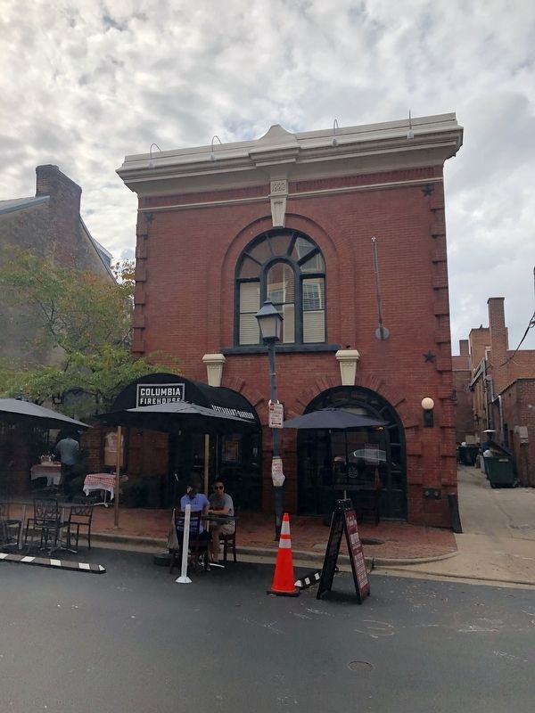
On South St. Asaph Street just south of King Street, on the right when traveling south.
Originally constructed in 1883 as
The Columbia Firehouse
Restored as a restaurant under the
direction of James J. Matthews, Jr.
for Marilyn and Harry Lewis.
Completed November 1981
— — Map (db m156845) HM
Near Jones Point Drive east of South Royal Street, on the right when traveling east.
George Washington lived in and traveled from this region, pursuing his dream of westward expansion—to connect the Atlantic Seaboard with the frontier West. His efforts to use the Potomac River as a commercial artery influenced industrialization . . . — — Map (db m127767) HM
On Oronoco Street just east of North Washington Street, on the right when traveling west.
This Federal-style townhouse and its adjoining twin were built ca. 1793. Original owner John Potts, Jr., secretary of the Potomac Company, deeded the house in 1799 to William Fitzhugh of Chatham, member of Virginia's Revolutionary Conventions and . . . — — Map (db m188751) HM
Near Jones Point Drive, 0.2 miles east of South Royal Street, on the right when traveling east.
Jones Point was once a wooded wilderness, ringed by marshes and periodically cut off from the mainland during high tide. American Indians made use of both woodland and wetland for food, tools and supplies. By the 17th century, Europeans had . . . — — Map (db m62028) HM
On The Strand south of King Street, on the left when traveling south.
In the early 1800s Alexandria was part of the District of Columbia and an important port with its own militia. In summer 1814, though, Alexandria’s militia had been sent to defend Maryland from the British invasion. So on August 28, four days . . . — — Map (db m81226) HM
On South Fairfax Street south of Prince Street, on the right when traveling north.
Physician General and Director of Hospitals, Middle Department, Continental Army, Charter member, Society of the Cincinnati. Author of the first American Pharmacopoea. President of Board of Trustees of Alexandria Academy, at General Washington's . . . — — Map (db m71757) HM
On North Royal Street at Cameron Street, on the right when traveling north on North Royal Street.
After Virginia seceded in the spring of 1861, Unionists met in Wheeling and organized a state government loyal to the U.S. under Gov. Francis H. Pierpont. The Restored Government, which sent representatives to the U.S. Congress and raised federal . . . — — Map (db m191972) HM
On King Street west of Saint Asaph Street, on the right when traveling east.
The 500 block of King Street has long been associated with retail trade in Alexandria. In the late 18th century, Adam Lynn, Sr. owned the quarter-block at this corner of King and St. Asaph Streets, where he operated a small bake shop selling . . . — — Map (db m115746) HM
On North Union Street at Queen Street, on the right when traveling north on North Union Street.
Alexandria, D.C.
In 1791, Alexandrians applauded their inclusion in the District of Columbia, believing that the town would benefit economically as part of the Federal district. These positive feelings toward inclusion in the District . . . — — Map (db m239716) HM
On King Street at Strand Street, on the left when traveling west on King Street.
Potomac River ferry companies date back to as early as 1740, when Hugo West received permission to operate a ferry from the Hunting Creek warehouse in Prince William over the Potomac River to Fraziers Point in Maryland "...the price for a man 1 . . . — — Map (db m143267) HM
On South Royal Street north of Wolfe Street, on the right when traveling north.
Founded 1795
by
Very Rev. Francis Jonatus Neale, S.J.
of Georgetown College
and
Colonel John Fitzgerald, Aide de Camp to General George Washington and one time Mayor of Alexandria
Prior to 1785, the Catholic community of Alexandria . . . — — Map (db m72355) HM
On Duke Street east of The Strand, on the left when traveling east.
An extensive amount of man-made land hides the original topographical feature that characterized the southernmost tip of Alexandria's crescent-shaped bay. This area was known from at least the 1760s as Point Lumley. As it does today, the town . . . — — Map (db m239746) HM
Near Wolfe Street, 0.1 miles east of South Union Street, on the right when traveling east.
John Hunter established one of the first shipyards in the City at the foot of Wilkes Street as early at 1783. The first "Potomac River Longboat" was built here at Hunters Shipyard in 1815. Shipbuilding and repair continued on this site for well . . . — — Map (db m143370) HM
On Diagonal Road west of Daingerfield Road, on the right when traveling west.
Early Uses
The West End was a rough and rowdy area just outside Alexandria's city limits. Stockyards, rail tracks, a tavern, and small shops catered to the farmers and drovers supplying the city's markets in the years before the Civil War. . . . — — Map (db m236050) HM
Near Cameron Street at North Columbus Street, on the left when traveling west.
The northern half of this block of Cameron Street, bounded by North Columbus Street on the east and North Alfred Street on the west, was the original site of the Moore-McLean Sugar Refinery. Within this half-acre lot was a five-story structure . . . — — Map (db m67028) HM
On North Fairfax Street at Cameron Street, on the right when traveling south on North Fairfax Street.
Here was held March 22 1785 the first conference between representatives Alexander Henderson and George Mason of Virginia and Major Daniel of St. Thomas Jenifer, Mr. Chase and Mr. Stone of Maryland. This conference resulted in the framing of the . . . — — Map (db m81249) HM
On this site stood Captain Joseph Pugmire and three lassies who conducted the first Salvation Army services in Alexandria. Later, the Salvation Army was located at 319 and 316 King Street from 1922 to 1965, when it moved to its present facility at . . . — — Map (db m143) HM
On South Fairfax Street south of King Street, on the right when traveling south.
Founded in 1792, the Stabler Leadbeater pharmacy operated on this site for 141 years serving many early patriots. The shop is a unique reminder of the period when manufacturing, wholesaling, and dispensing of medicines were combined as a single . . . — — Map (db m875) HM
On King Street at South Fairfax Street, on the right when traveling east on King Street.
The Stabler-Leadbeater Apothecary Museum traces one of America's oldest continuously-run family businesses that combined manufacturing, wholesaling and retailing. Founded in 1792, and operated just across Fairfax Street until 1933, the pharmacy . . . — — Map (db m115762) HM
On South Pitt Street south of Prince Street, on the right when traveling south.
Built circa 1818 by Josiah Hewes Davis (1783-1862), rope maker and ship chandler who operated a rope walk at Jones Point. Purchased in 1847 by William Stabler (1795-1852) as a home for John Leadbeater (1808-1860), his brother-in-law and business . . . — — Map (db m71772) HM
On Thompsons Alley east of North Union Street, on the right when traveling east.
Gato Class WWII Fleet Submarine
Conducted nine war patrols in the Pacific.
Awarded four Battle Stars
Commissioned March 17, 1943
De-commissioned April 1, 1960 — — Map (db m115779) HM
On South St. Asaph Street just south of Prince Street, on the right when traveling south.
The Alexandria Custom House stood here in 1917. Built in 1858, the third floor of the three-story granite building housed the U.S. District Court for the Eastern District of Virginia. On November 27, 1917, a hearing in that courtroom would play a . . . — — Map (db m182671) HM
On Prince Street east of South Columbus Street, on the right when traveling east. Reported permanently removed.
Built in 1802 by Thomas Swann
Purchased in 1832 by
Henry Daingerfield and enlarged.
St. Mary's Academy 1889 - 1943
Restored in 1978 by
Mr. and Mrs. Hugh E. Witt
— — Map (db m134974) HM
On Prince Street east of South Columbus Street, on the right when traveling east.
A private residence listed in the National Register of Historic Places by the United States Department of the Interior. Registered as a Virginia Historic Landmark by the Virginia Board of Historic Resources.
Thomas Swann House, 1802-1833. . . . — — Map (db m145963) HM
Near Ford's Landing Way east of Franklin Street, on the left when traveling south.
One of the last and most architecturally important of the industrial facilities constructed on the waterfront was the Alexandria Branch of the Ford Motor Company. Designed by Albert Kahn (1896-1942) and built on wood pilings over the Potomac River . . . — — Map (db m69852) HM
On King Street (Virginia Route 7) at South Columbus Street, on the right when traveling east on King Street.
Between 1820 and 1860, Alexandria had a thriving cabinet and furniture-making industry, primarily along King Street, between Royal and Alfred streets. Among the city's best-known furniture makers—and business rivals—were Charles Koones and James . . . — — Map (db m195643) HM
On King Street (Virginia Route 7) at North Washington Street (Virginia Route 400), on the right when traveling east on King Street.
One block south is The Alexandria Lyceum, formed as a public education organization in 1834 by Quaker schoolmaster Benjamin Hallowell and other civic leaders. In 1839, the founders joined with the Alexandria Library Company to construct a . . . — — Map (db m115718) HM
On Wharf Street east of Ford's Landing Way, on the right when traveling west. Reported unreadable.
The Alexandria Marine Railway Company was founded in 1849 at the site of the former Keith's Wharf. Until the Depression of 1857, the firm refitted and repaired the sailing craft that plied the harbors of Alexandria, Georgetown and Washington. The . . . — — Map (db m127769) HM
On King Street at South Lee Street, on the right when traveling east on King Street.
Home to the Northern Virginia Fine Arts Association, the Athenaeum is a fine example of Greek Revival architecture, with a long and colorful history of occupation. The building was constructed between 1851 and 1852 as the Bank of the Old Dominion, . . . — — Map (db m115768) HM
On Prince Street just west of South Royal Street, on the right when traveling west.
Here Union Governor Francis Harrison Pierpont established the “Restored Government of Virginia” and used the building as the official Governor's Residence
1863-65
This Property is protected by a preservation easement held by . . . — — Map (db m71611) HM
On North Fairfax Street south of Cameron Street, on the left when traveling south.
From March 26 through April 20, 1755, the town of Alexandria served as the center of operations for Major General Edward Braddock, commander-in-chief for British forces in North America. He chose the finest house in town, John Carlyle's, as his . . . — — Map (db m156495) HM
Near North Fairfax Street north of King Street, on the right when traveling north. Reported permanently removed.
The Carlyle House, completed in 1753, was the residence of one of the 18th-century Alexandria's leading citizens—John Carlyle—a prosperous merchant and landowner.
1. Although the earliest known engraving of the Carlyle House appeared . . . — — Map (db m129174) HM
Near Ford's Landing Way at Franklin Street, on the left when traveling south.
With the outbreak of war in the spring of 1861, Alexandria was immediately occupied by Federal troops as a bulwark in the defenses of the national capital, and the city became a central distribution center for men and material for the Army of the . . . — — Map (db m70411) HM WM
On North Union Street at Cameron Street, on the right when traveling north on North Union Street.
In 1860, Alexandria was a vibrant southern city boasting a population of 12,652 and 96 firms which produced everything from bark to tin-ware. During the U.S. Presidential campaign in the fall of 1860, business-minded Alexandrians were decidedly . . . — — Map (db m115781) HM
On South Washington Street (Virginia Route 400) at Prince Street, on the right when traveling south on South Washington Street. Reported permanently removed.
The unarmed Confederate soldier standing in the intersection of Washington and Prince Streets marks the location where units from Alexandria left to join the Confederate Army on May 24, 1861. The soldier is facing the battlefields to the South where . . . — — Map (db m8605) HM
On Strand Street just south of King Street, on the right when traveling north.
On January 1, 1808, the earliest date allowed by Article I, Section 9 of the United States Constitution, the Act Prohibiting Importation of Slaves went into effect and stated, "It shall not be lawful to import or bring into the United . . . — — Map (db m188750) HM
Near Wharf Street near Ford's Landing Way, on the right when traveling west. Reported unreadable.
After 10,000 B.C., as glacial ice retreated, small bands of Paleo-Indians moved into the vicinity of what would become Alexandria. Moving frequently within wide areas, these bands hunted game and collected the plant resources of the spruce/pine . . . — — Map (db m127773) HM
On Duke Street (Virginia Route 236) at Holland Lane, on the right when traveling west on Duke Street.
The West End in the 19th century centered on Duke Street and Diagonal Road. Large undeveloped, the area was devoted to stockyards, agricultural shipment, and "a" notorious business: the slave trade. The house at 1707 Duke Street (left) was part . . . — — Map (db m151028) HM
Near Jones Point Drive, 0.2 miles South Royal Street, on the right when traveling east.
From the late 1700s into the 1800s, the pastoral calm of the Point was interrupted repeatedly—by soldiers manning cannon emplacements, by surveyors laying out the boundaries of the nation's capital, by workers at a ropewalk and the lighthouse, . . . — — Map (db m62029) HM
This house was built and owned for twenty years by the Fairfaxes of Belvoir
Col. William Fairfax 1691 ▿▿▿ 1757
Col. George William Fairfax 1724 ▿▿▿ 1787
Patrons Instructors and friends of Washington, . . . — — Map (db m92329) HM
On Wharf Street east of Ford's Landing Way, on the right when traveling west. Reported unreadable.
On January 22, 1791, George Washington appointed Andrew Ellicott and Benjamin Banneker to survey the boundaries of the "District of Columbia," to be the home of the Federal government of the United States. The President instructed the surveyors to . . . — — Map (db m127771) HM
Archaeological evidence indicates that humans have occupied the Potomac River Valley for over 13,000 years and Jones Point for almost 9,000 years. Attracted by the rich resources of Hunting Creek marsh, indigenous people built temporary structures . . . — — Map (db m127779) HM
Near Jones Point Drive, 0.3 miles east of South Royal Street, on the left when traveling east.
This dock, constructed of reinforced concrete on concrete and wood pilings, was once the last stop for cargo ships under construction at Jones Point's World War I shipyard. Here, ships received final fittings before heading out for service. The dock . . . — — Map (db m62201) HM
On North Royal Street at Caneron Street, on the right when traveling south on North Royal Street.
This Doorway was returned to Gadsby's Tavern From the Metropolitan Museum by Charles Beatty Moore, Colonel. U.S.A. Retired (1881-1951) in 1949 by the Alexandria Assocation. 1949 marked the Bicentennial of Alexandria's Founding. — — Map (db m71777) HM
Near Cameron Street at North Royal Street, on the left when traveling west. Reported permanently removed.
Underground ice wells were used in the 18th and 19th centuries to store ice for use during the warm months. In Alexandria, blocks of ice were cut from the Potomac River. Ice was placed in this well through a square opening which is marked in the . . . — — Map (db m129196) HM
On Cameron Street at North Royal Street, on the right when traveling east on Cameron Street.
In 1793, the Alexandria Common Council granted permission for John Wise to build an icehouse underneath the corner of Royal and Cameron Streets as part of his construction of the new City Tavern.
This brick-lined ice well is a unique . . . — — Map (db m243155) HM
1. The garden that you see today is conjectural no detailed information exists about the design of John Carlyle's garden though Carlyle's 1780 estate inventory together with other documentary evidence indicates that he had one on this site. It is . . . — — Map (db m171061) HM
On King Street (Virginia Route 7) west of South Payne Street, on the left when traveling west.
Throughout most of the nineteenth century, three buildings stood on this section of 1300 to 1312 King Street, on what previously had been vacant land. The main structures on Lots 1 and 2 have been preserved, whereas the building on Lot 3 was . . . — — Map (db m236062) HM
On South Union Street just north of Wales Alley, on the right when traveling north.
The pineapple has been a symbol of hospitality since the days of the early American colonies. The legend began with the sea captains of New England, who sailed the Caribbean Islands and returned to the colonies bearing their cargo of fruits, . . . — — Map (db m197473) HM
Near Jones Point Drive east of South Royal Street, on the right when traveling east.
In the 1850's, Alexandria was one of the busiest seaports in the Chesapeake region. To help guide Potomac River ship traffic, the federal government built the Jones Point lighthouse, illuminating the beacon for the first time on May 1, 1856. It . . . — — Map (db m60242) HM
In 1833, Josiah Davis constructed a narrow, 400-yard-long building where rope was manufactured for ship's rigging, a once-thriving maritime industry for the nearby port of Alexandria.
[Caption:]
The Jones Point ropewalk was a two-story . . . — — Map (db m127774) HM
Three hundred years ago, a river as wide as the Capital Beltway—Great Hunting Creek—emptied into the Potomac River at this spot. In the absence of good roads, this river and its tributaries were vital corridors for travel and trade. . . . — — Map (db m62000) HM
On South Washington Street (Virginia Route 400) south of Prince Street, on the right when traveling south.
Built in 1839 by the Alexandria Lyceum Company under the leadership of Benjamin Hallowell, this building housed the Alexandria Library and was the scene of concerts, meetings, debates and lectures featuring such speakers as John Quincy Adams and . . . — — Map (db m8607) HM
On King Street at South Fairfax Street, on the right when traveling east on King Street.
Close to midnight on Tuesday, August 8, 1899, Benjamin Thomas, a 16-year-old Black Alexandrian, was lynched from a lamppost on this corner.
Earlier, white rioters attacked the City Jail on N. St. Asaph Street, where they seized and dragged . . . — — Map (db m188809) HM
On King Street, on the right when traveling east. Reported permanently removed.
The Marshall House stood upon this site, and within the building on the early morning of May 24, 1861 James W. Jackson was killed by Federal soldiers while defending his property and personal rights as stated in the verdict of the coroners . . . — — Map (db m65490) HM
On North Royal Street south of Cameron Street, on the right when traveling south.
The Memorial Fountain in this garden rededicated on June 2, 1967 by The Mount Vernon Chapter National Society of The Daughters of the American Revolution on the occasion of the Dedication of tavern square the fountain was previously located at the . . . — — Map (db m241669) WM
On George Washington Memorial Parkway north of Prince Street, on the right when traveling north.
In 1804, the Methodist Episcopal congregation of Alexandria moved from its first meeting house in Chapel Alley to this location. The meeting house remained here until 1942, when the building was disassembled and relocated to its present site, where . . . — — Map (db m134972) HM
Near Jones Point Drive east of South Royal Street, on the right when traveling east.
After the Revolutionary War, the new nation searched for a permanent seat of government. President George Washington favored a 10-mile square territory along the Potomac River that encompassed the economically important ports of Georgetown and . . . — — Map (db m141071) HM
On Church Street east of South Washington Street, on the right when traveling east.
About eighty feet to the west of this site the original Saint Mary's Church was constructed between 1794–1796 by father Francis Neale, S. J., at the corner of what is now Washington and Church Streets. It was the first catholic church in the . . . — — Map (db m86633) HM
On Prince Street east of South Columbus Street, on the left when traveling east.
The Patton-Fowle House - attributed by some to renowned early American architect Charles Bulfinch of Boston - is one of America's finest examples of Federal high-style architecture. Sharing many of the same features as the historic Octagon House, . . . — — Map (db m134973) HM
On King Street at North Lee Street, on the left when traveling east on King Street.
From this point, King Street slopes gently down to the Potomac. But when Alexandria was founded in 1749, the new town was perched on a high bluff some 20 feet above the river. The town was established on a shore of a crescent-shaped bay that . . . — — Map (db m115766) HM
Near Jones Point Drive, 0.3 miles South Royal Street, on the right when traveling east.
In response to a shortage of ships and shipbuilding facilities at the start of World War I, the U.S. government decided to enter the shipbuilding business. In 1917, the U.S. Emergency Fleet Corporation was created and eventually oversaw construction . . . — — Map (db m62022) HM
On King Street at Fairfax Street, on the left when traveling east on King Street.
Owned by William Ramsay, a founder of Alexandria in July, 1749, and first Mayor. Restored by the City of Alexandria in 1956 and dedicated to the memory of Mrs. Robert Miller Reese (Rebecca Ramsay) (1870–1955), great-great-granddaughter of . . . — — Map (db m144) HM
On King Street east of North Fairfax Street, on the right when traveling west.
Oldest house in Alexandria owned by William Ramsay, a Founder, Trustee, and the first Mayor of Alexandria in 1749. Later occupied by his son Dennis Ramsay and his descendants. Interest in preserving the house was initiated by Edward . . . — — Map (db m115763) HM
Near Jones Point Drive, 0.2 miles east of South Royal Street, on the right when traveling east.
Despite occasional conflicts between European settlers and local Indians, Mistress Margaret Brent of Saint Mary’s City, Maryland, was granted the first land patent on Piper’s Island (later known as Jones Point) in 1654. An extraordinary woman for . . . — — Map (db m62026) HM
On Prince Street east of The Strand, on the right when traveling west.
From 1898 to 1911, a 181-foot-long side wheel steamboat based out of Washington, D.C., called the River Queen would sometimes dock at the wharf at the foot of Prince Street in Alexandria. Build in 1864, it had first gained fame as the site . . . — — Map (db m239733) HM
On Prince Street just east of St. Asaph Street, on the right when traveling east.
The Core Structure here was built in the 1780s, with the front rooms added in the early/mid 1800s
Home of Patsy and Jack Ticer and their family 1961 - 2018
Patricia S. "Patsy" Ticer - First woman Mayor of Alexandria
Served on City . . . — — Map (db m146437) HM
On King Street at South Washington Street (Virginia Route 400), on the right when traveling east on King Street.
At the turn of the 20th century, Alexandria was home to at least a dozen pharmacies, two of them associated with the name Timberman. Charles Parke Custis Timberman and other brother John Elmer Winfield Timberman were born near Pohick Church in . . . — — Map (db m115723) HM
On North Union Street north of Fayette Alley, on the right when traveling north.
The Torpedo Factory Art Center Building was formerly a munitions plant during World Wars I and II. In September, 1974, the Art Center opened in the Torpedo Factory as a Bicentennial project. The idea was conceived by Marian Van Landingham, a . . . — — Map (db m98078) HM WM
On North Union Street south of Cameron Street, on the right when traveling south.
Originally called the United States Naval Torpedo Station, the Torpedo Factory was built during World War I, and was specifically designed for the fabrications of dangerous naval ordnance. The building was barely completed when that war ended in . . . — — Map (db m115784) HM
On North Union Street north of Fayette Alley, on the right when traveling north.
The Naval Torpedo Station construction began on November 12, 1918, the day after the armistice which ended World War I. building One housed machine shops, the dispensary, and a cafeteria, while Building Two held torpedo storage and offices. The . . . — — Map (db m239720) HM
Near Diagonal Road (Virginia Route 7) south of King Street (Virginia Route 7), on the right when traveling south. Reported permanently removed.
Welcome to Old Town Alexandria! Experience historical charm with contemporary flair from the river to the rails
Plan
Alexandria Visitors Center at Ramsay House
Knowledgeable staff help you create a perfect plan for your visit. . . . — — Map (db m115143) HM
Near Cameron Street east of North Union Street, on the right when traveling east. Reported permanently removed.
Welcome to Old Town Alexandria! Experience historical charm with contemporary flair from the river to the rails
Plan
Alexandria Visitors Center at Ramsay House
Knowledgeable staff help you create a perfect plan for your . . . — — Map (db m167097) HM
On King Street at South Union Street, on the right when traveling east on King Street.
Few periods of Alexandria's history have been more tumultuous than the War of 1812. During the first decade of the 19th century, Great Britain's interception of American ships, impressment of U.S. seamen, and support of Indian aggression along the . . . — — Map (db m115769) HM
On Cameron Street near North St. Asaph Street, on the left when traveling west.
Replica of Washington's Town House.
Lot purchased by George Washington 1763. House completed 1769 – torn down 1855. Rebuilt by Gov. and Mrs. Richard Barrett Lowe 1960. Bricks & stones from excavation used in construction. Worth . . . — — Map (db m147) HM
On South Pitt Street north of Prince Street, on the right when traveling south.
Built for investment in 1797 by
George Washington
Lot purchased by Washington
in 1763
Conveyed by will in 1799 to
Martha Washington — — Map (db m71716) HM
Near Strand Street just south of Prince Street, on the right when traveling south.
Archaeological Evidence of a Working Seaport
The archaeologists tasked with researching this property on the 200 block of South Union Street used a host of sources such as historic photographs, lithographs, deeds, court cases, newspapers, . . . — — Map (db m195635) HM
Near The Strand at King Street, on the right when traveling north.
(Panel 1)
The Alexandria waterfront reflects the perpetual relationship between people and the Potomac River. The Old Town shore documents a history rich in individual and collective maritime, commercial, and cultural concerns. Waterfront . . . — — Map (db m81244) HM
On North Columbus Street at Cameron Street on North Columbus Street. Reported permanently removed.
Christ Church embodies God's unbounded love by embracing, liberating, and empowering people—whoever you are and wherever you find yourself on your journey of faith.
An Episcopal church designed by James Wren in the colonial Georgian style . . . — — Map (db m129192) HM
On Jones Point Drive east of South Royal Street, on the right when traveling east.
The open vistas, recreational fields, or fishing pier may be what drew you to Jones Point Park, but archaeological and historical evidence shows that this land has been attracting people for a multitude of reasons during the last 9,000 years. Over . . . — — Map (db m127766) HM
Near Jones Point Drive east of South Royal Street, on the right when traveling east.
According to Lord Baltimore's land grant from King Charles I in 1632, Maryland owns the "River of Pattowmack...unto the further Bank of said River." But with Virginia's shoreline constantly shifting how could the border be fixed? In 1929, a survey . . . — — Map (db m60179) HM
Near Wilkes Street at South Royal Street, in the median.
The Wilkes Street Tunnel was part of the Orange & Alexandria Railroad, founded in 1848 to promote trade with western Virginia. The Orange and Alexandria inaugurated its track in Alexandria on May 7, 1851 with a run to the north end of Union Street . . . — — Map (db m72346) HM
On South Union Street, 0.1 miles south of Wolfe Street, on the right when traveling south.
The Wilkes Street Tunnel was part of the eastern division of the Orange & Alexandria Railroad, founded in 1848 to promote trade with western Virginia. The Orange & Alexandria inaugurated its track in Alexandria on May 7, 1851 with a run from the . . . — — Map (db m143378) HM
On South Union Street just north of Gibbon Street, on the left when traveling north.
Now a city park, Windmill Hill got its name from the windmill built here on Miller's Cliff by inventor John R. Remington in 1843. With soothing winds and a grand view of the busy port, the hill was the scene of fashionable promenades and numerous . . . — — Map (db m143377) HM
On North Fairfax Street at Cameron Street, on the right when traveling north on North Fairfax Street.
Here, on April 16, 1789 George Washington was for the first time publicly addressed as President of the United States the first and greatest of many distinguished successors in that high and honorable office. This tablet was erected in commemoration . . . — — Map (db m156476) HM
On Cameron Street east of North Pitt Street, on the right when traveling east.
In honor of all from the City of Alexandria who served and died during World War I
Robert Adams •
George Anderton •
Stanley Bernard •
Herbert Bernhard •
William Bradley •
Bernard Brock •
William Brown •
Christopher Cloxom • . . . — — Map (db m129195) WM
Near Jones Point Drive, 0.2 miles east of South Royal Street, on the right when traveling east.
In May 2000, this rudder was recovered along the banks of the Potomac River near Jones Point. Measuring over 22 feet high and 4.5 feet wide, the rudder is of the variety used to outfit steel cargo ships constructed between 1918 and 1920 at the . . . — — Map (db m61952) HM
Near Jones Point Drive, 0.2 miles South Royal Street, on the right when traveling east.
In the 20th century, Jones Point continued to be shaped by the changing needs of the federal government. With proximity to the capital and access to land and river transportation, the peninsula was chosen as the site for several military . . . — — Map (db m62030) HM
On South Lee Street south of Franklin Street, on the right when traveling north.
A small group of Christian believers established Zion Baptist Church in 1864 on the corner of Wolfe and South Union Streets, northeast of the Wilkes Street Tunnel. At the end of the Civil War, Zion Baptist was one of five African American Baptist . . . — — Map (db m239753) HM
On North Royal Street north of Montgomery Street, on the right when traveling north.
Buried beneath this canal stone lies Lock #3 of the Alexandria Canal, which connected the Harbor of Alexandria with the Chesapeake and Ohio Canal in Georgetown, D.C. between 1843 and 1886. After Crossing the Potomac on an aqueduct bridge near the . . . — — Map (db m80668) HM
On Montgomery Street just west of North Pitt Street, on the right when traveling west.
The Alexandria Canal officially opened on December 2, 1843. The seven-mile long canal extended from the Chesapeake and Ohio Canal in Georgetown to Alexandria's ports on the Potomac River. Boats brought coal, limestone, iron ore, port and . . . — — Map (db m147123) HM
On North St. Asaph Street north of Pendleton Street, on the right when traveling north.
This building, originally built as a bottling plant for the Robert Portner Brewing Company in 1912, was purchased along with the land surrounding it by the American National Red Cross in the spring of 1941. It served as the organization's Eastern . . . — — Map (db m134971) HM
On Montgomery Street at North Fairfax Street, on the right when traveling west on Montgomery Street.
This area, called "Cross Canal," was a neighborhood of black residents who settled across from the canal shortly after the Civil War. The canal, located just north of this marker, extended from the Potomac River to Washington Street, thence north to . . . — — Map (db m129476) HM
On Mt. Vernon Trail at Canal Center Plaza (First Street), on the right when traveling south on Mt. Vernon Trail.
During the Civil War, thousands of African Americans fled to the Union-controlled city, either moving into government-run freedmen camps; settling into historically black neighborhoods such as the Bottoms, or seeking out affordable housing on the . . . — — Map (db m237644) HM
On Wythe Street just east of North Pitt Street, on the right when traveling east.
Populated almost exclusively by Black residents, the racially segregated neighborhood of The Berg evolved by necessity to have its own set of dwellings, amenities, and social institutions. Houses like the "five frame shanties" that stood on this . . . — — Map (db m204836) HM
On Wythe Street just east of North Pitt Street, on the right when traveling east.
Neighborhoods function as support networks and knit people together. For Alexandria's Black residents in the late-19th and early-20th centuries, establishing neighborly bonds was essential for survival within a racist, segregated society.
In . . . — — Map (db m204833) HM