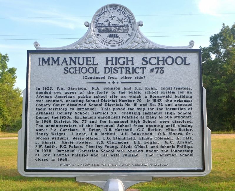
On Immanuel Road 0.5 miles east of Arkansas Route 33, on the left when traveling east.
The Immanuel Industrial Institute, a rural boarding school, was established in 1910 by the White River District Association of Missionary Baptist Churches to educate the African American children of the White River District. The first building was . . . — — Map (db m225240) HM
Near Old Post Road 0.8 miles south of State Route 169.
When Napoleon I became Emperor of France in 1799, he envisioned the establishment of a vast "French Empire in America". He began in 1800 when he won control of Louisiana from Spain.
Constant threat of war with England soon forced him to . . . — — Map (db m108650) HM
Near Old Post Road 0.7 miles south of State Route 169.
This Stone Was Taken
from
Ruins of Old Bank, built
at
Arkansas Post, 1839.
Arkansas Post State Park.
Created by Act of Legislature 1929.
Introduced by Ballard Deane,
Representative, Arkansas County.
Act . . . — — Map (db m108550) HM
Near Old Post Road 0.8 miles south of State Route 169.
The land passed from France to the United States in 1803 with the Louisiana Purchase. Arkansas then became a territory on March 2, 1819: the Post of Arkansas was designated its capital.
The Territorial Secretary Robert Crittendon, acting in . . . — — Map (db m108651) HM
The United States and several European powers vied for control of the lower Mississippi Valley. Arkansas Post was the key to that control.
In 1541 Hernando de Soto explored the territory which is now Arkansas. Sieur de La Salle further . . . — — Map (db m108647) HM
Near Old Post Road 0.7 miles south of State Route 169.
The Regent of France authorized a settlement at the Post of Arkansas in 1722. These early settlers were on good terms with the Quapaw Indians who "exhibited a great spirit of friendliness and hospitality toward the French". Cotton was introduced . . . — — Map (db m108648) HM
On Old Post Road at State Route 169, on the right when traveling south on Old Post Road.
Here on the Grand Prairie you tread on
soil laid down over the centuries as the
mighty Mississippi and Arkansas Rivers
brought down their precious cargoes of
silt from the northern uplands.
The footprints of many were pressed into
this . . . — — Map (db m108486) HM
Near Old Post Road 0.7 miles south of State Route 169.
In 1763 the Post of Arkansas became
Spanish territory when, by the Treaty of
Paris, the French King ceded Louisiana
to Spain. For several years after the
transfer, French officers and soldiers
remained at Arkansas Post.
In 1771 the . . . — — Map (db m108551) HM
Near Old Post Road 0.4 miles south of State Route 169.
A bitter winter rain had turned the ground to mud. But the Confederate
soldiers had to keep digging. These rifle pits, lying just a few feet from where
you stand, were far from finished. Though exhausted and hungry, the soldiers
were ordered to . . . — — Map (db m107874) HM
Near Old Post Road 0.5 miles south of State Route 169.
The Confederate scouts were alarmed. Looking down river to your right, one exclaimed, "One could hardly see anything in the background but smokestacks."
Union soldiers disembarked from their transports. All night, knee deep in mud, they . . . — — Map (db m108509) HM
On Old Post Road 0.5 miles south of State Route 169, on the left when traveling south.
You wouldn't have got us had it not been for your damned gunboats.
John Dunnington, colonel, chief of ordnance
Fort Hindman's cannon fired at the nine gunboats
bearing down on them. Confederate gunners had . . . — — Map (db m108072) HM
Near Old Post Road 0.4 miles south of State Route 169.
Half the Yankees in the West [were coming].
Confederate scout
I expected Mary would be a widow before I got 10 rods [55 yards]. . . . — — Map (db m107858) HM
Near Old Post Road 0.8 miles south of State Route 169.
In the early 1800's the land in front of you was an important
center of trade and government on the edge of the Arkansas River
wilderness. Here were the homes, stores, taverns, mills,
docks, and busy streets of the Post of Arkansas. This . . . — — Map (db m108428) HM
Near Old Post Road 0.8 miles south of State Route 169.
The succession of outposts here, remote from centers of New
World empire, symbolized a dream of the imperial age: to
connect the Gulf of Mexico to North America's vast interior
by the great rivers that drained it.
Following British . . . — — Map (db m108485) HM
Near Old Post Road 0.8 miles south of State Route 169.
Spanish Explorer Hernan de Soto passed this way in 1542. Nearly
130 years later Father Marquette, the French missionary and explorer,
reached the nearby mouth of the Arkansas. In 1682 Robert Cavelier,
Sieur de la Salle, claimed this territory for . . . — — Map (db m108407) HM
Near Old Post Road 0.8 miles south of State Route 169.
Arkansas Post was not a single fort and trading center. From
1686 until 1863 there were no fewer than seven posts on the
Arkansas River between here and the Missişsippi. The flags
of five nations flew over them.
The 1686 post . . . — — Map (db m108464) HM
Near Old Post Road 0.8 miles south of State Route 169.
During the American Revolution, Arkansas Post
belonged to the Spanish, allies of the American
patriots. In 1783, British partisans led by James
Colbert raided the Spanish village and fort here.
It was one of the last engagements of the . . . — — Map (db m108483) HM
Near Old Post Road 0.5 miles south of State Route 169.
Standing here in January 1863, you would have seen
Confederate Fort Hindman. In what is now the water, the
fort stood atop a 25-foot high bluff The fort's cannon could
fire a mile up or down the river to protect the breadbasket
of Arkansas. The . . . — — Map (db m108511) HM
On State Highway 276 0.2 miles east of Riley Lane (State Highway 276 Spur), on the right when traveling east.
Bayou Meto Cemetery was established in 1876 after Allen "Uncle Gip" Gibson donated one acre of land to the local community for use as a cemetery. Gibson, a former Union soldier, was an early settler of the Bayou Meto Community. A skilled . . . — — Map (db m178029) HM
On State Highway 276 just east of Lumsden Road, on the left when traveling east.
Listed in the Arkansas Register of Historic Places in 2003, the Bayou Meto Schoolhouse is one of the last remaining historic school buildings in the area. The first Bayou Meto school was established in 1875, within the Pampas School District. It . . . — — Map (db m178030) HM
On State Highway 276 0.1 miles east of Riley Lane (Highway 276 Spur), on the left when traveling east.
Thirteen charter members founded Mount Zion Methodist Episcopal Church South in 1881 and constructed a small, wooden church building in the southwest corner of the Bayou Meto Cemetery. The structure contained handmade pews, oil lamps, and
a wood . . . — — Map (db m178026) HM
On Arkansas Route 153 1 mile north of Route 1, on the left when traveling north.
On this site from September 1862 to January 1863 was the encampment of a celebrated Texas cavalry company. Captain Alf Johnson's Spy company was active in conducting reconnaissance and small unit actions near Helena while maintaining vigilance on . . . — — Map (db m107804) HM
On Arkansas Route 153 north of Starks Lane, on the right when traveling north. Reported permanently removed.
Named for Captain Robert Crockett, grandson of the famous David (Davey) Crockett, this community was a flourishing river port during the second half of the 19th century. The Crockett Rifles (Company H, 1st Arkansas Infantry), first Confederate . . . — — Map (db m107807) HM
On Arkansas Route 153, on the right when traveling north.
Named for resident William Finley Crockett, son of frontiersman Davy Crockett, this community was once a flourishing river port during the second half of the 19th century and into the early years of the 20th century. Steamboats loaded with cotton, . . . — — Map (db m201389) HM
On U.S. 165 near Post Bayou Lane, on the right when traveling north.
From the 19th century to present day, the economy of Arkansas County has been based on agriculture, especially rice farming. An essential part of rice farming
is having enough water at the right time to flood the fields. Natural water sources . . . — — Map (db m192660) HM
On U.S. 165 0.1 miles south of Gander Street Road, on the right when traveling north.
Founded by France in 1686, Arkansas Post was the first European settlement in what is now the state of Arkansas. It was located along the Arkansas River at various sites near here over the years. The Spanish occupied it after 1763 until the . . . — — Map (db m294844) HM
On U.S. 165 at State Route 169, on the right when traveling north on U.S. 165.
On January 9, 1863, Gen. John McClernand and Adm. David D. Porter led a 30,000 man army and a flotilla of Union gunboats up the Arkansas River to confront Gen. T.J. Churchill's 5,000 Confederates at Arkansas Post. The gunboats bombarded Fort Hindman . . . — — Map (db m107701) HM
On Belnap Avenue at NCC Camp Road, on the right when traveling east on Belnap Avenue.
Here on June 17, 1862 a Federal fleet of eight vessels attempted to force its way upstream past Confederate shore defenses commanded by Captain Joseph Fry. The Confederates disabled the Union gunboat Mound City with heavy casualties before . . . — — Map (db m107918) HM
On Broadway Avenue at Main Street, on the right when traveling east on Broadway Avenue.
J. Deane and Son was a hardware store that
served this area beginning in 1890. During the
steamboat era, St. Charles was a thriving river
boat community and this was its largest retail
outlet.
Founded by Joe Deane, who arrived here . . . — — Map (db m108563) HM
On West Broadway Avenue at Arkansas Street, in the median on West Broadway Avenue.
[Northeast face]
Officers and men killed on
the U.S.S. Mound City
{List of 124 dead}
[Northwest face]
Near this spot, on June 17, 1862,
a decisive engagement was
fought between the Conf-
ederates entrenched and
the . . . — — Map (db m108071) WM
On North Buerkle Street (U.S. 63/165) just north of Madison Street, on the left when traveling north.
In August and September, 1862, General Mosby M. Parsons
and 800 men of the Missouri State Guard encamped here,
after a perilous crossing of the Mississippi River into Desha
County. This small force of infantry and artillery blocked
enemy . . . — — Map (db m167369) HM
On South Grand Avenue at East 7th Street, on the right when traveling north on South Grand Avenue.
[south side] The Grand Avenue United Methodist Church was organized in 1887 with seventy-four members as a congregation of the Methodist Episcopal Church and became the first Methodist congregation organized in Stuttgart. This . . . — — Map (db m262900) HM
On Buerkle Street, on the left when traveling south.
Named for educator Leroy Davis Holman, North Carolina-born educator who began teaching Stuttgart’s African American children in 1907. The school, first located at Porter and Lincoln Streets, was rebuilt in 1924 with Rosenwald Foundation funding. . . . — — Map (db m201392) HM
On Michigan Avenue (U.S. 79), on the right when traveling east.
Green Grove Cemetery got its official beginning when Martin and Minnie Buerkle sold two acres of property to the Trustees of Green Grove Cemetery Association in September of 1903. This cemetery was likely the first burial ground dedicated to serving . . . — — Map (db m234960) HM
On 321 South Main Street near East 4th Street, on the left when traveling north.
Rev. Adam Buerkle brought a
colony of German Lutherans to
this area in 1878. In 1880 he named the post office
Stuttgart in honor of his native city. Stuttgart was
platted in 1884 and incorporated in 1889. Col. Bob Crockett,
a grandson of Davy . . . — — Map (db m191876) HM
On South Main Street south of Fourth Street, on the right when traveling south.
The citzens at this time paused and reflected on those pioneers who with sweat and tears gave this community its heritage and traditions. This memorial recognizes the dedication and efforts of all those who made this centennial a year to remember . . . — — Map (db m167630) HM
On Arkansas Route 44 0.5 miles north of Tichnor Blacktop Rd., on the left when traveling south.
First Lieutenant Lloyd Leslie “Scooter” Burke, born 29 September 1924 at Tichnor, served in the 1st Cavalry Division, U.S. Army. In action near Chong-dong, Korea, 28 October 1951, Lt. Burke exhibited conspicuous gallantry above and beyond the call . . . — — Map (db m289705) HM
On North Arkansas Street at East Iowa Street, on the right when traveling north on North Arkansas Street.
The first railroad through this area was the Mississippi, Ouachita and Red River, begun in 1854 and extending westward from the Mississippi River. In 1875 it became the Little Rock, Mississippi and Texas railroad. In 1887 the north-south main line . . . — — Map (db m229488) HM
On Grand Lake Loop (Arkansas Route 8) at Cariola Road when traveling south on Grand Lake Loop.
From the close of
the Civil War to
the beginning of the twentieth century, Cariola
Landing at Grand Lake was one of the largest
shipping points on the Mississippi River south
of Helena, Arkansas. Cotton from a large area
west and south of . . . — — Map (db m159402) HM
On East Lee Street 0.5 miles south of South Main Street, on the right when traveling south.
Site of the Eudora settlement's first business district. After a ferry across Bayou Macon was established in 1846, Cariola Landing was accessible to Arkansas Communities to the west and Louisiana towns to the south. Merchants built stores along the . . . — — Map (db m158053) HM
On Gum Street 0.5 miles south of South Archer Street (State Highway 159).
Site of Mount Carmel, the first organized community in the Eudora area. John Booth donated land for a Presbyterian Church and a seminary for girls. Rev. Benjamin Shaw was director and pastor. Booth and Shaw are buried in Mount Carmel Cemetery. The . . . — — Map (db m158466) HM
Near Main Street at North Lakeshore Drive ( Highway 144).
The county seat of Chicot County was located at Columbia in 1823, where it remained until 1855. The county took its name from Point Chicot, on the Mississippi. — — Map (db m89773) HM
On North Lakeshore Drive (State Highway 144) at Main Street, in the median on North Lakeshore Drive.
Front (West side)
"To the Confederate
soldiers of Chicot
County, the record
of whose sublime
self sacrifice and
undying devotion is
the proud heritage
of a loyal posterity."
Rear (East side)
We care not . . . — — Map (db m90255) WM
On North Lakeshore Drive 0.8 miles south of Club Drive, on the right when traveling south.
In April 1923 Lindbergh, then an unknown 21-year-old mail pilot, experienced engine trouble and landed his airplane on the now-abandoned golf course behind this site of the old Lake Village County Club. He remained in Lake Village overnight. During . . . — — Map (db m89779) HM
On Highway 257 near Bluebird Lane, on the right when traveling south.
The town of Columbia was located on the Mississippi River about two miles east of this point. In 1833 the Chicot County seat was moved to Columbia from Villemont due to river bank erosion. Columbia became a thriving port and the location of a . . . — — Map (db m167545) HM
On Sunnyside Road 2 miles east of Causeway Road, on the left when traveling east.
In Memoriam Hyner Cemetery established in 1898 marks the site of those devout, courageous Italian immigrants who came to America in 1895 settling and working at Sunnyside Plantation and throughout the Delta area. They established schools, . . . — — Map (db m168476) HM
On South Lakeshore Drive at St. Marys Street ( Highway 144), on the right when traveling south on South Lakeshore Drive.
In 1895 Austin Corbin, a New York banker and land developer, working with immigration officials brought 100 families from north central Italy to grow cotton at Sunnyside, a plantation located between the Mississippi River and Lake Chicot. These . . . — — Map (db m89774) HM
Near State Highway 142 0.9 miles east of Robert Mazzanti Road (Parish Road 505).
When Arkansas went to war in 1861, Lycurgus and Lydia Johnson and their family stayed with their home at Lakeport. By 1862, U.S. gunboats were common on the Mississippi River, and on Sept. 6, 1862, Confederate troops burned 158 bales of cotton at . . . — — Map (db m89797) HM
Near State Highway 142 0.9 miles Robert Mazzanti Road (Parish Road 505).
Side 1
The Lakeport Plantation house was constructed circa 1859 for Lycurgus and Lydia Taylor Johnson. The skilled craftsmanship and lasting character are testaments to those who built the house. It is preserved in remembrance of all who . . . — — Map (db m90491) HM
On St. Marys Street (State Highway 144) at Commerce Street, on the right when traveling west on St. Marys Street.
Jim Kelley, a slave, organized this church in 1860. His owner allowed the use of this plot of this plot of ground on which to build a church. On May 15, 1873, Mr. and Mrs. William B. Street deeded the property to the trustees of the church. New Hope . . . — — Map (db m89777) HM
On U.S. 278 0.4 miles east of U.S. 65, on the right when traveling east.
This home was built about the year 1848 for John H. Saunders and his wife Martha A. Pettit Saunders. During the Civil War engagement at Ditch Bayou in 1864 the house was used as a hospital for soldiers of both armies. A number of military dead were . . . — — Map (db m107737) HM
On U.S. 82 at Pugh Circle, on the right when traveling west on U.S. 82.
It is the morning of June 6, 1864. Rain has created a muddy mess. To your left are four cannon. To your right are 600 cavalrymen and two more cannon. These men served under Confederate Colonel Colten Greene. To your front is Ditch Bayou, and 700 . . . — — Map (db m90432) HM
On U.S. 82 0.1 miles west of Pugh Circle, on the right when traveling west.
The battle at Ditch Bayou was a Federal effort to drive Confederates away from the Mississippi River, where the Confederates had been harassing Union shipping. Even though the Confederates were outnumbered here, they were able to inflict heavy . . . — — Map (db m90418) HM
On Desoto Avenue at Sprague Street, on the right when traveling east on Desoto Avenue.
Between the years of 1873 and 1927, Arkansas
City had one of the most important ports on the
Mississippi River. Before being an established
port, a steamboat landing was located at this
site as early as 1834, This port was also known
as the . . . — — Map (db m299004) HM
On Robert S Moore Avenue at Natchez Street, on the left when traveling east on Robert S Moore Avenue.
The county seat of Desha County, named for Captain Ben Desha. Was located in 1838, soon after the creation of the county, at Napoleon where it remained until 1874. — — Map (db m299001) HM
On Capitol Street near Kate Adams Avenue, on the right when traveling east.
Accompanied by Henri de Tonti on their way down the Mississippi River in 1682. Landed near the mouth of the Arkansas River. They spent several days at a nearby village of Quapaw or Arkansas Indians. — — Map (db m299688) HM
On Capitol Street close to Kate Adams Avenue, on the left when traveling south.
The Flood of 1927 was the greatest disaster
ever suffered by the county. Breaks in the
Arkansas and Mississippi River levees, within
the county covered the land with water from
4 to 30 feet in depth in April and part
remained until summer. Most . . . — — Map (db m299003) HM
On Morning Star Avenue, on the right when traveling west.
Johnny Johnson was born January 19,
1918 to Leroy and Gertrude Johnson in
Arkansas City, Arkansas. This house is his
boyhood home. Johnny Johnson and his
mother relocated to Chicago, Illinois in
1933. He was a renowned
entrepreneur , . . . — — Map (db m299919) HM
On Capitol Street at Kate Adams Avenue on Capitol Street.
The X.O. Pindall Law Office was built
Circa 1882 and is on the National Register of Historic Places.
The law office of the former Arkansas Governor was given to the
University of Arkansas at Monticello by Robert and Beverly Moore on December 13, . . . — — Map (db m299918) HM
On Pickens Street (U.S. 165) east of Jack Dante Drive, on the right when traveling east.
The Arkansas Indians (the down stream people), a branch of the Quapaw tribe, lived in Desha County. Their presence was first recorded by Marquette and Joliet, French explorers, in 1673. They were known as les Beaux Hommes. La Salle while . . . — — Map (db m107809) HM
This important river port, county seat of Desha County from 1838 to 1874, was located 24 miles east at the junction of the Arkansas River with the Mississippi. The town was finally abandoned after most of it washed into the Mississippi River. — — Map (db m107758) HM
On Kelso Road 0.3 miles east of State Route 1, on the right when traveling east.
In mid-February 1863, Confederate troops at Cypress Bend fired on Union transports on the Mississippi River. On Feb. 19, a force of Union cavalry and mule-mounted infantry set out in pursuit. The Union troops drove off enemy pickets before . . . — — Map (db m107693) HM
On North 2nd Street just north of Oak Street, on the left when traveling north.
The first school in McGehee was started about 1903 in a one room frame building at this location, with Miss Puntney as teacher. In 1905, in this building Reverend J. L. Cannon organized the McGehee First Methodist Episcopal Church. There were ten . . . — — Map (db m229500) HM
On North First Street (U.S. 278) at East Seamans Drive, on the right when traveling north on North First Street.
In memory of each serviceman in Desha County, who gave their lives for their country in World War II. The American Legion Auxiliary Unit of the Claude E. Jaynes American Legion Post 79, passed a resolution to make Seamans Drive the site for this . . . — — Map (db m229497) WM
Near State Highway 1 0.5 miles north of Rohwer Road, on the left when traveling north.
Where you now see cotton fields, 432 barracks once housed about 8,000 Japanese Americans.The Camp was surrounded by a barbed wire fence linking eight guard towers from which armed guards watched the camp and internees. The cam was divided by . . . — — Map (db m170077) HM
Near State Highway 1 0.5 miles north of Rohwer Road, on the left when traveling north.
Years of discrimination and the Japanese attack on Pearl Harbor led to the forced removal and imprisonment of Japanese Americans. All Japanese Americans on the West Coast were affected by the forced evacuation - including women and . . . — — Map (db m169429) HM
Near State Highway 1 0.5 miles north of Rohwer Road, on the left when traveling north.
Internees tried to re-create a life they might have lived
outside of confinement.
Earning money in camp was a constant struggle for internees, bills still had
to be paid on property left behind and everyone needed to buy clothes, . . . — — Map (db m169434) HM
Near State Highway 1 0.5 miles north of Rohwer Road, on the left when traveling north.
Dedicated to the Patriotic Japanese-American men from Rohwer Internment Camp who sacrificed their lives in the service of their country in World War II.
U.S. Fifth Army - 100 Battalion - 442 Regiment
Cassino Anzio . . . — — Map (db m170092) HM WM
Near State Highway 1 north of Rohwer Road, on the left when traveling north.
The Rohwer internment camp included a 500-acre area for internee living quarters and more than 10,000 acres of surrounding land for farming and timber harvesting. Officially labeled a relocation center, the internment camps for Japanese . . . — — Map (db m167628) HM
Near Arkansas Route 1 north of Rohwer Road, on the left when traveling north.
The U.S. entry into World War II led to the forced removal of-
nearly 120,000 Japanese Americans from the West Coast
The Japanese Navy attacked Pearl Harbor, Hawaii on December 7,
1941, and America declared war on Japan the next day. . . . — — Map (db m167967) HM
Near State Highway 1 0.5 miles north of Rohwer Road, on the left when traveling north.
Babies were born, children went to school, adults had jobs, and some people died here during the three years that the Rohwer camp operated. The traditional Japanese family structure was threatened by the camp's communal living conditions: . . . — — Map (db m170078) HM
Near State Highway 1 0.5 miles north of Rohwer Road, on the left when traveling north.
"Let's teach (our children) that even in a life such as this, our hearts do not despair, that,
although wwe left behind many material things, we did not leave our courage, our fortitude,
and our ability to do the best with the least." . . . — — Map (db m169055) HM
Near State Highway 1 0.5 miles north of Rohwer Road, on the left when traveling north.
The relocation center sites were chosen because of their distance from the West
Coast and for their suitability and isolation as secured, closed camps. Inside The Relocation Center The loss of their former lives was profound for the . . . — — Map (db m169430) HM
Local Ingenuity
Most communities along today's Delta Heritage Trail were once railway town-settlements created near rail routes where none existed before. One exception is Laconia Circle, an area close to Snow Lake with an
18-mile levee . . . — — Map (db m299923) HM
A Brief History of this Railroad
1873 New York financier Jay Gould purchases Union Pacific Railroad stock.
1879 Gould buys controlling interest in Missouri Pacific Railroad.
1881 Missouri Pacific buys control of St . . . — — Map (db m299926) HM
Walk or bike this trail
into the heart of the
Arkansas Delta.
Your journey on this
historic rail route
transports you through
time, connects you with
communities, and reveals
rich Delta heritage.
The State of Arkansas acquired this . . . — — Map (db m299927) HM
Era Ends, Era Begins
Large-scale farm and businesses were established here during the early 1800s, when people relied heavily on riverboats for transportation. As a formal community, Snow Lake was established with the arrival of the railroad . . . — — Map (db m299922) HM
On Arkansas Route 1 at Front Street, on the right when traveling east on Arkansas Route 1.
Watson became the county seat of Desha County after Napoleon was abandoned to the Mississippi River. Lewis W. Watson donated the land and built the courthouse near this site. The county seat was moved to Arkansas City in 1880. Watson remained the . . . — — Map (db m107757) HM
On U.S. 165 near Ellington Farm Road (County Road 210), on the right when traveling north.
On February 19, 1942, Pres. Franklin
Roosevelt signed into law Executive
Order No. 9066, interning over 120,000
persons of Japanese ancestry, and
this act irrevocably changed their
lives. The majority of these people
were American citizens. As . . . — — Map (db m170318) HM
Near South Main Street (State Highway 83) south of East Shelton Avenue, on the right when traveling south.
Drew County, named for Governor Thomas S. Drew, was organized in 1845 and Monticello was laid out in 1849 as the county seat. Many pioneer families whose sons and daughters became prominent in the affairs of State and Nation lived here. — — Map (db m85085) HM
On South Main Street (State Highway 83) south of East Shelton Street, on the right when traveling south.
(side 1)
Sixteen Confederate companies were raised in Drew County during the Civil War. Two, the "Confederate Stars" and "Selma Rifles," joined the 3rd Arkansas Infantry and fought with the Army of Northern Virginia. Three, the "Cut-off . . . — — Map (db m85087) HM
Near West Oakland Avenue at North Hyatt Street, in the median.
To the
Confederate
Soldiers
of Drew County.
1861—1865
Furl that banner! True,
'tis gory,
yet 'tis wreathed around
with glory,
and 'twill live in song
and story,
though its folds are
in the dust.
Father Ryan . . . — — Map (db m85093) WM
Erected by the citizens of Drew County in honor of all who served or who may serve and dedicated to those who gave their lives that we might be free. Veterans Day 1988.
World War I
B.C. Bast, George F. Cater, Chisley Garrison, Forrest . . . — — Map (db m85089) WM
On West Barraque Street close to North Main Street, on the right when traveling west.
To honor Auguste La noir de Serville Hero of the American Revolution French Marine served under Count de Grasse Wounded Yorktown, VA Oct. 14, 1781 Died Jefferson Co. Ark. Dec. 30, 1828 — — Map (db m30579) HM
On West Barraque Street at North Pine Street, on the right when traveling west on West Barraque Street.
This street was named for Antoine Barraque (1773-1858), native of France, soldier of Napoleon, and one of this area's earliest settlers. Founder of New Gascony in this county, he was a man of property and Indian sub-agent. Trusted and liked by the . . . — — Map (db m30577) HM
On West Barraque Street just west of North Main Street, on the right when traveling west.
During the morning and early afternoon of October 25, 1863, Colonel Powell Clayton commander of federal troops occupying Pine Bluff, successfully repulsed a three-pronged confederate attack of forces of General John S. Marmaduke. Cotton bales . . . — — Map (db m30578) HM
On South Main Street at South Olive Street (Business U.S. 63), on the right when traveling north on South Main Street.
Beginning 10 miles northwest of Pine Bluff, this storied bayou flows 300 miles through 6 Arkansas counties and 2 Louisiana parishes before emptying into the Ouachita River in north Louisiana. Indian mounds dotted its banks. Immigrants travelled it . . . — — Map (db m30581) HM
On West 4th Avenue east of South Oak Street, on the right when traveling east.
Boone-Murphy House
Following the Union capture of Little Rock on Sept. 10, 1863, citizens of Pine Bluff asked that a Union garrison be stationed there for their protection. Gen. Frederick Steele sent the veteran 5th Kansas Cavalry and 1st . . . — — Map (db m170444) HM
Miss Willie K. Hocker, author, educator, member of
Pine Bluff Chapter, National Society, Daughters
of the American Revolution and designer of
the Arkansas Flag. The flag design was adopted
in 1913 by the General Assembly. The twenty-five stars . . . — — Map (db m305311) HM
Miss Willie K. Hocker, author, educator, member of
Pine Bluff Chapter, National Society, Daughters
of the American Revolution and designer of
the Arkansas Flag. The flag design was adopted
in 1913 by the General Assembly. The twenty-five stars . . . — — Map (db m305312) HM
On West Barraque Street just east of North Main Street, on the right when traveling west.
The first court house in Jefferson County created in 1829 and named for President Thomas Jefferson was erected on this site at (Pine Bluff) in 1833. Meanwhile, sessions of the county court had been held first at the house of Joseph Bonne and second . . . — — Map (db m30580) HM
On South Cherry Street at West 36th Avenue, on the left when traveling south on South Cherry Street.
has been listed in the National Register of Historic Places by the United States Department of the Interior.
Erected in 1937
Restored in 2007 — — Map (db m305509) HM
On West Barraque Street at North Chestnut Street, on the right when traveling west on West Barraque Street.
In 1818 a French trapper, Joseph Bonne landed on the south bank of the Arkansas River with his dog and gun near the location of the original Jefferson County Courthouse. Driven to this high bluff after flood waters had threatened his homesite at . . . — — Map (db m30576) HM
On University Drive (U.S. 79) 0.2 miles south of Watson Boulevard, on the right when traveling south.
In 1875, Joseph Corbin the son of former slaves, became the founder and principal of Branch Normal College (now UAPB) where he served until 1902. A profound mathematician, outstanding musician, linguist, and holder of bachelor and masters degrees . . . — — Map (db m70701) HM
426 entries matched your criteria. The first 100 are listed above. Next 100 ⊳