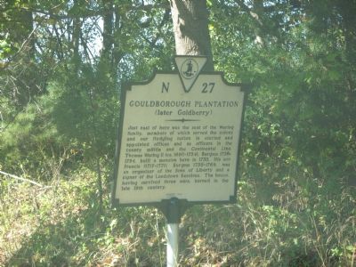
On Tidewater Trail (U.S. 17) south of Gold Berry Lane (County Route 689).
Just east of here was the seat of the Waring family, members of which served the colony and our fledgling nation in elected and appointed offices and as officers in the county militia and the Continental Line. Thomas Waring II (ca. 1690–1754), . . . — — Map (db m86179) HM
On Tidewater Trail (U.S. 17) north of Old Courthouse Road, on the right when traveling north. Reported permanently removed.
About half a mile northeast stood the old courthouse and clerk’s office of Rappahannock County, 1665–1693. To this courthouse Thomas Goodrich and Benjamin Goodrich, ordered to appear with halters around their necks, came to express their . . . — — Map (db m3084) HM
On US 17 at Quarter Hill Road, on the right when traveling north on US 17.
Along the Rappahannock River near here lived the Portobacco Indians, who may have been part of the Portobaccos of Maryland. After moving to Virginia in the 1650's, they lived here in peace with their Indian neighbors, who spoke a similar dialect and . . . — — Map (db m7406) HM
On Historyland Highway (U.S. 17) north of Gwynnfield Road (County Route 703), on the right when traveling north.
West of here, on the ridge between the Mattaponi and Rappahannock Rivers, the Rappahannock Indians built a fort to defend themselves from hostile settlers and other Indians during Bacon’s Rebellion in 1676. An order of the colonial Virginia Council . . . — — Map (db m3082) HM
On Tidewater Trail (U.S. 17) west of Forest Grove Road (Virginia Route 718), on the right when traveling east.
Thomas Washington, an African American man, was lynched on 23 March 1896 for allegedly attempting to assault the young daughter of a prominent white citizen. A boy found Washington’s body hanging from a tree about 1/8 mile southwest of here. A . . . — — Map (db m191126) HM
On US 17 at VA 631 Lloyd's Road, on the right when traveling south on US 17. Reported permanently removed.
A mile and a half west stands Fonthill, built in 1832 by Robert Mercer Taliaferro Hunter. He served variously as United States senator, Confederate secretary of state, Confederate States senator, and as a member of the peace commission that met with . . . — — Map (db m7409) HM
On Tidewater Trail (U.S. 17) 0.3 miles north of Layton’s Landing Road (Virginia Route 637), on the right when traveling north.
Two miles northeast on the Rappahannock River, at
Coleman's Town, George Southern was operating a ferry by 1679. In the early 1700s, the Ley and Layton families ran the ferry, an ordinary, and a wharf. By midcentury, the community had become
a hub . . . — — Map (db m214590) HM
On Tidewater Trail (U.S. 17) north of Laytons Landing Road, on the right when traveling north.
Two miles east near the river, Richard Coleman planted a frontier settlement and trading post in 1652. By 1660 a church was built, to which every man was required to come armed for protection against the Indians. — — Map (db m3085) HM
On Tidewater Trail (U.S. 17) at Muddy Gut Road (Virginia Route 607), on the right when traveling south on Tidewater Trail.
Angel Visit Baptist Church, one of the oldest African American churches in Essex County, was formed in 1866 when African American members withdrew from white-led Ephesus Baptist Church after Emancipation. The congregation purchased land here in 1867 . . . — — Map (db m194986) HM
On River Place (Virginia Route 680) 0.3 miles north of Shellfield Road ( Route 666), on the right when traveling north.
Here in 1861 Confederates constructed an eight gun "water battery" principally for the defense of Fredericksburg. The guns were manned by the 55th Infantry Regiment located 500 yards N.W. The cannons were moved and the fort abandoned March 1862 . . . — — Map (db m25231) HM
On Tidewater Trail (U.S. 17) at Johnville Road ( Route 611), on the right when traveling east on Tidewater Trail.
Located two miles N.E. on Rappahannock River at Lowry’s Point was a Confederate eight gun “water battery” constructed in 1861. Here at Dunnsville was located Camp Byron, home of Company F (Essex Light Dragoons), Ninth Cavalry, C.S.A.; the company . . . — — Map (db m3081) HM
On Tidewater Trail (U.S. 17) near Boston Road ( Route 610), on the right when traveling north.
Founded by
Southside Rappahannock Baptist Association
Education - The Hope of a Glorious Future
Original Trustees
Willis Brook • Ned Fitzgerald • C. H. Newman • D.R. Page • Thomas Pollard • J. R. Ruffin • N.A. Wiggins • W. E. Robinson - . . . — — Map (db m191128) HM
On Tidewater Trail (U.S. 17) 0.2 miles north of Boston Road, on the right when traveling north.
The Woman’s Baptist District Missionary Convention conceived the Old Folks Home in 1894 and opened it here ca. 1909 to care for aged, destitute Black people, some of whom had been enslaved. Under the supervision of a live-in matron and an all-woman . . . — — Map (db m269170) HM
On Tidewater Trail (U.S. 17) 0.2 miles north of Boston Road ( Route 610), on the right when traveling north.
The Southside Rappahannock Baptist Association opened the Rappahannock Industrial Academy here in 1902 to provide secondary education for African Americans at a time when no public high schools were available to them in the area. Supported by . . . — — Map (db m198433) HM
On Sadlers Hill Road at Sadler Hill Road, on the right when traveling south on Sadlers Hill Road.
Middlesex County. Area 146 square miles. Formed in 1673 from Lancaster, and named for an English County. Rosegill frequented by Colonial Governors, is here.
Essex County. Area 258 square miles. Formed in . . . — — Map (db m7494) HM
On Tidewater Trail (U.S. 17) at Wheatland Road ( Route 638), on the right when traveling west on Tidewater Trail.
One mile north, on the Rappahannock River, is Saunders's Wharf, a center of transportation and commerce from the mid-1800s until 1937. Steamboats on the busy route that linked Fredericksburg and Baltimore picked up crops, livestock, raw . . . — — Map (db m214593) HM
On US 17 north of Spindle Shop Road, on the right when traveling north.
This was the principal church of St. Anne's Parish, which was formed in 1704 from Sittenburne Parish and encompassed Essex County. According to tradition, part of the present church was built about 1719 with an addition constructed in 1731, but . . . — — Map (db m7407) HM
At Piscataway, near here, the northern followers of Bacon the Rebel assembled in 1676. On July 10, 1676, an action was fought with Governor Berkeley's supporters, some of whom were killed and wounded. Several houses were burned. Passing here, the . . . — — Map (db m7489) HM
King and Queen County. Area 320 Square Miles. Formed in 1691 from New Kent, and named for King William III and Queen Mary. The family of George Rogers Clark long lived in this county.
Essex County. Area 258 Square . . . — — Map (db m7492) HM
To the north, after the 1644-1646 conflict between colonists and groups still loyal to the Powhatan chiefdom, the Mattaponi Indians found refuge on the headwaters of Piscataway Creek. Officers of then Old Rappahannock County signed a treaty with the . . . — — Map (db m7491) HM
Founded nearby as Piscataway Baptist Church on 13 Mar. 1774, Mt. Zion Baptist Church was the first Baptist church in the region. Endeavoring to stop the spread of the Baptist movement, local authorities arrested Baptist ministers John Waller, John . . . — — Map (db m7493) HM
On Tidewater Trail (U.S. 17) north of Ashdale Road, on the right when traveling north.
Just to the East stood Mann Meeting House, the first Methodist Episcopal Church in this region. It was built before 1794 and abandoned about 1880. The site is now occupied by the Macedonia Colored Baptist Church. — — Map (db m3080) HM
On Water Lane just south of Queen Street (U.S. 360), on the left when traveling south.
This was the family burying ground of Benjamin and Elizabeth Blake who lived nearby on Prince Street. Their graves on the left-hand (north) side date to the early 1830s. Their daughter, Frances Blake married eminent physician and Virginia Delegate, . . . — — Map (db m176100) HM
Near Tidewater Trail (U.S. 17) 1 mile north of Airport Road ( Route 627), on the left when traveling north.
(panel 1)
Bountiful Marshes
Meandering stretches of area rivers, such as this section of the Rappahannock, produce large freshwater marshes. Virginia Indians valued them as rich sources of food, often locating settlements nearby. . . . — — Map (db m97182) HM
On Queen Street (U.S. 360) at Newbill Drive (County Route T-1013), on the right when traveling west on Queen Street.
British Raid on Tappahannock. On 2 Dec. 1814, British naval forces commanded by Capt. Robert Barrie shelled and seized the town of Tappahannock during the War of 1812. Aiding the British were three companies of African American Colonial . . . — — Map (db m97117) HM
On Newbill Drive (County Route T-1013) north of Prince Street, on the left when traveling north.
(panel 1)
Enduring Records
Smith explored the Rappahannock River in 1607 and 1608. He wrote of his encounters with local tribes in colorful stories of skirmishes and other adventures. Many of these accounts, some published 16 years . . . — — Map (db m97129) HM
On Prince Street 0.1 miles west of Cross Street, in the median.
Erected to soldiers of Essex and those who fought with them. They fought for the principles of state sovereignty and in defense of their homes. To maintain these rights the gallant sons of this
gallant county marched gladly to the front and did . . . — — Map (db m278250) WM
On Queen Street (U.S. 360) at Newbill Drive ( Route T-1013), on the left when traveling east on Queen Street.
The town was founded in 1680 under the name of Hobbs His Hole. In 1682, a port was established here and called New Plymouth. In 1808, the name was changed to Tappahannock. The British Admiral Cockburn shelled the town, December 1, 1814. An old . . . — — Map (db m25248) HM
The Hutchinson Tract of the Rappahannock River Valley National Wildlife Refuge consists of 727 acres of restored grasslands and mixed hardwood forests which complement the forests that buffer Mount Landing Creek. The attentive visitor may enjoy . . . — — Map (db m97196) HM
On Prince Street east of Water Lane, on the left when traveling east.
At seventeen years of age, Mechel Silber waved goodbye to Zapytow, Ukraine. It was 1909 and with little more than a dream of America, he arrived at Ellis Island. But a tireless work ethic, a reputation for unwavering integrity, and the heartfelt . . . — — Map (db m235825) HM
The National Wildlife Refuge System is a collection of United States lands and waters managed specifically for wildlife. Units of the system stretch across the continent, from the icy north shore of Alaska to the balmy Florida Keys, and beyond to . . . — — Map (db m97197) HM
How easy it is to celebrate large spectacular forms of wildlife such as the bald eagle. Yet there are thousands and perhaps millions of vital wildlife species on this refuge, each of which could easily fit in a teaspoon. Among these important . . . — — Map (db m97190) HM
On Cross Street 0.1 miles north of Prince Street, on the right when traveling north.
Here was born Thomas Ritchie, November 5, 1778. In 1804, he established the Richmond Enquirer, which ran until 1877, the most noted of Virginia newspapers. Ritchie was a political leader in Virginia and an editor of national fame. In 1845, he became . . . — — Map (db m25253) HM
High-Quality Housing These rare habitats, dominated by native warn-season grasses such as little bluestem, Indian grass, and eastern gamma grass, provide food and cove for wildlife year around—even standing up to snow and ice. . . . — — Map (db m97192) HM
On Prince Street just east of North Church Lane (U.S. 17/360), on the right when traveling west.
This willow oak tree was planted on November 6, 1980, by the XYZ Fellowship Club (Senior Citizens) of Essex County in commemorating the tricentennial of the foundation of the Town of Tappahannock in 1680, and the formation of Essex County in 1692, . . . — — Map (db m176102) HM
On Prince Street east of Water Lane, on the left when traveling east.
Tobacco was currency and the cash crop at the heart of the colonial Virginia economy when Captain Richard Hobbs of the ship Elizabeth and Mary anchored here in the 1660s and received a land patent for 800 acres. Colonel Benjamin Goodrich was . . . — — Map (db m235824) HM
On Prince Street east of Water Lane, on the left when traveling east.
On this spot for many years stood the home of William Silas "Bill" Manning and his family. Born into slavery in King George County about 1856, the son of Sampson and Winnie Hampton Manning, William was the pilot of a tugboat on the Rappahannock, a . . . — — Map (db m235823) HM
On U.S. 17 0.2 miles south of Daingerfield Road, on the right when traveling north.
In this region near the Rappahannock River once stood the Rappahannock Indian village of Toppahanock. When John Smith explored this region in 1607 and 1608, he found fourteen Rappahannock villages along both banks of the river. The river was the . . . — — Map (db m7410) HM
On US 17 just south of Parker Place, on the right when traveling south.
William “Bill” Moore was born in Georgia in 1893. Nearby stood his home and barbershop. Paramount recorded Moore in Chicago in 1928 and released eight songs, some of the earliest by an African American folk performer from Virginia. They . . . — — Map (db m7411) HM
On Main Street (Business U.S. 17) at John Clayton Memorial Highway ( Route 3/14), on the right when traveling west on Main Street.
The Texas Corporation was founded in Beaumont, Texas, in 1901; by 1948, it became the first gas company to have locations in all 48 United States. The Texaco brand thrived throughout the twentieth century and in 2001 merged with Chevron to create . . . — — Map (db m175998) HM
On Main Street (Business U.S. 17) just west of John Lemon Lane, on the right when traveling west.
Along York River's Purtan Pay in Gloucester County lies perhaps the most significant American Indian landscape in the eastern United States. Captain John Smith describes visiting Werowocomoco below where the York divides into the Mattaponi and . . . — — Map (db m175984) HM
On Hickory Fork Road (Virginia Route 614) 0.2 miles west of Ark Road (Route 606), on the left when traveling west.
Bethel Baptist Church is one of the oldest African American congregations in Gloucester County. Founded nearby in 1867, it was originally known as the Old Sassafras Stage Church. Members of the congregation built a wooden structure here in 1889, . . . — — Map (db m30098) HM
On Business US 17 at Belroi Road, in the median on Business US 17.
Seven and one-half miles southwest is Cappahosic, where a ferry was established early in the eighteenth century. On the old charts, this indian district lay between Werowocomoco and Timberneck Creek. Powhatan is said to have offered it to Capt. John . . . — — Map (db m7518) HM
On Cappahosic Road (Virginia Route 618) at Almondsville Road (Route 662), on the left when traveling south on Cappahosic Road.
Here is Cappahosic, where a ferry was established early in the eighteenth century. On the old charts, this Indian district lay between Werowocomoco and Timberneck Creek. Powhatan is said to have offered it to Capt. John Smith for "two great guns and . . . — — Map (db m30106) HM
County of Gloucester, VA. Re-erected 1766 on site of building destroyed by fire. Restored, remodeled and clerks office building added 1956.
Carl M. Lindner & Son A.I.A. Architects, Richmond, Virginia Wray & Richardson, General Contractors, . . . — — Map (db m7524) HM
On Main Street (Business U.S. 17) just west of John Lemon Lane, on the right when traveling west.
Native to parts of Europe and Northern Africa, daffodils were introduced to Britain by the Romans after they invaded and captured the country in AD 43. Daffodils (also known as "Lent Lilies") spread naturally and eventually became the favorite . . . — — Map (db m175990) HM
On George Washington Memorial Highway (U.S. 17) south of Hickory Fork Road. Reported missing.
Dr. Walter Reed, U.S. Army medical officer and bacteriologist, was born on 13 Sept. 1851 in a nearby cottage at Belroi. He received medical degrees from the University of Virginia medical school and Bellevue Hospital College in New York City. In . . . — — Map (db m248784) HM
On Old Rosewell Lane at Rosewell Plantation Road, on the right when traveling east on Old Rosewell Lane.
Before you is the pavilion that occupied the center of the east wall between the chimneys. The pavilion was one of two matching projections that accommodated the interior stairways on the east and west sides of the mansion. The unique arrangement . . . — — Map (db m297972) HM
On George Washington Memorial Highway (U.S. 17) south of Piney Swamp Road, on the right when traveling north.
Two miles west stood Fairfield, also called Carter's Creek plantation, one of the most distinguished of Virginia's early brick homes. Built about 1694 for Lewis Burwell (ca.1651–1710), the house was a grand T-shaped structure, with distinctive . . . — — Map (db m297643) HM
On Cappahosic Road (Virginia Route 618) 0.1 miles north of Foxhaven Drive, on the right when traveling south.
On this site stood the Gloucester Agricultural and Industrial School, commonly known as Capahosic Academy, a private high school built for African Americans before public high schools were available to them. Founded in 1888 by local alumni of . . . — — Map (db m30104) HM
On Main Street (Business U.S. 17) just west of John Lemon Lane, on the right when traveling west.
In 1938 the Garden Club of Gloucester held the first annual Daffodil Show, sponsored by the American Daffodil Society. Growers competed for awards. The show continues to this day.
The same year, the first local daffodil tour was proposed by . . . — — Map (db m175988) HM
On Main Street (Business U.S. 17) west of John Lemon Lane, on the right when traveling west.
⚫ Historical Points of Interest
1. Abingdon Episcopal Church
2. Rosewell
3. Bethel Baptist Church
4. Walter Reed's Birthplace
5. Woodville Rosenwald School
6. Zion Poplars Baptist Church
7. Ware Episcopal Church . . . — — Map (db m309531) HM
On Main Street (Business U.S. 17) just east of Justice Drive, on the right when traveling west.
Gloucester County was formed from York County in 1651. Its first brick courthouse, one of Virginia's earliest, was erected by 1685. The county built a new courthouse in 1766, and the Virginia General Assembly established Botetourt Town around it in . . . — — Map (db m175983) HM
On Main Street (Business U.S. 17) at Belroi Road, on the right when traveling east on Main Street.
The courthouse was built in 1766. The debtors prison is also old. A skirmish occurred near here between Confederate and Union cavalry, January 29, 1864. — — Map (db m248726) HM
On Main Street (Business U.S. 17) west of John Lemon Lane, on the right when traveling west.
Botetourt Town becomes Gloucester Courthouse
In the early days of the county, Gloucester Town, now known as Gloucester Point, served as the main population center. This began to change in 1769 when Botetourt Town was established to the . . . — — Map (db m309529) HM
On Main Street (Business U.S. 17) at John Clayton Memorial Highway ( Route 3/14), on the right when traveling west on Main Street.
You are standing at the east end of the Gloucester Downtown Historic District, which extends down Main Street to the historic court circle. The district was listed on the National Register of Historic Places in 2010 and includes 57 contributing . . . — — Map (db m175996) HM
On George Washington Memorial Highway (U.S. 17) at Bacons Lane, on the right when traveling west on George Washington Memorial Highway.
Near here stood Gloucester Hall (built ca. 1660s), where Bacon’s Rebellion effectively ended with the fatal illness of its leader, Nathaniel Bacon, in 1676. In 1684, this house served as the first Virginia residence of Royal Governor Francis Howard, . . . — — Map (db m74702) HM
Near Main Street (Business U.S. 17), on the right when traveling north.
Confederate authorities frequently stored arms and supplies in civilian warehouses, commercial buildings, and depots. County seats, with their commodious courthouses, jails, and offices, also were used, and Federal authorities routinely raided . . . — — Map (db m44389) HM
On T C Walker Road (Virginia Route 629) 0.1 miles south of Seawell Avenue ( Route 1411), on the left when traveling south.
Built on this site in 1921 the Gloucester Training School became the first public high school for African Americans in Gloucester County. Thomas Calhoun Walker, Jr. and others constructed a wooden building with gifts from the Rosenwald Fund and . . . — — Map (db m30114) HM
On George Washington Memorial Highway (U.S. 17) at T C Walker Road (Route 629), on the right when traveling south on George Washington Memorial Highway. Reported missing.
John Page, planter, scholar, and Revolutionary patriot, was born in 1743 at Rosewell, three miles west of here. He attended the College of William and Mary with Thomas Jefferson. The two men developed a lifelong friendship and shared an interest . . . — — Map (db m297641) HM
On Main Street (Business U.S. 17) at John Clayton Memorial Highway ( Route 3/14), on the right when traveling west on Main Street.
You are standing at the intersection of John Clayton Memorial Highway, leading to Mathews County, and George Washington Memorial Highway, which connects Gloucester to the Lower Peninsula and has been a main thoroughfare since the colonial . . . — — Map (db m176006) HM
The Garden Club, Gloucester, VA, planted a live oak tree, April 2, 1957 near old clerk's office on Court Green in honor of the internationally revered botanist and for 51 years, 1722-1773, Clerk of Gloucester County, VA.
Scientiae Artis . . . — — Map (db m7525) HM
Near Main Street (Business U.S. 17) just west of John Lemon Lane, in the median.
The Garden Club, Gloucester, VA. planted a live oak tree, April 2, 1957 near old clerk's office on court green in honor of this internationally revered botanist and for 51 years, 1722-1773, clerk of Gloucester County, VA.
Scientiae artis . . . — — Map (db m175981) HM
On Main Street (Business U.S. 17) west of John Lemon Lane, on the right when traveling west.
Captain John Smith explored the Chesapeake Bay in the early 1600s seeking precious metals and a passage to the Pacific. He traveled the James, Chickahominy and York rivers in 1607, and led two major expeditions on the Chesapeake from Jamestown in . . . — — Map (db m309523) HM
On Main Street (Virginia Route 14) west of John Lemon Lane, on the right when traveling west.
Explore the places John Smith and the English colonists traveled in the early 1600s. Learn about the thriving American Indian communities and the bountiful richness that still exists in the region today.
For more than 3,000 miles, the . . . — — Map (db m309525) HM
On U.S. 17 0.1 miles north of Enos Road (Route 613), on the right when traveling south.
A mile and a half west is the site of Marlfield, an eighteenth-century dwelling built by the Buckner family. It was purchased in 1782 by William Jones, who gave the house its name. Jones was among the first Virginia planters to use marl in his . . . — — Map (db m7515) HM
Near Old Rosewell Lane at Rosewell Plantation Road, on the right when traveling east.
You are standing before the north front of the Rosewell mansion, the home for over a century of the influential Page family, leaders of government and society in Virginia from the mid-1600s to America's Federal period. Begun about 1725, by Mann . . . — — Map (db m297974) HM
On Main Street (Business U.S. 17) at John Clayton Memorial Highway ( Route 3/14), on the right when traveling west on Main Street.
The land on which the Edge Hill Service Station now stands was onced in the early 1900s by Thomas Calhoun Walker, a prominent African American in the community. He was the first African-American lawyer in Gloucester County and in 1888 founded the . . . — — Map (db m176009) HM
On George Washington Memorial Highway (U.S. 17) south of Chesapeake Road, on the right when traveling south.
Petsworth Parish, one of the four parishes of colonial Gloucester County, was established in the middle of the 17th century. The first parish church was located some four miles southwest near Purtan Bay on the York River. Across Route 17 were built . . . — — Map (db m52645) HM
On George Washington Memorial Highway (U.S. 17) south of Chesapeake Road, on the right when traveling south. Reported permanently removed.
This is the site of Poplar Spring Church of Petsworth Parish. In 1694, Old Petsworth Church was abandoned in favor of this church. It was considered the finest church of colonial Virginia. In 1676, the followers of Bacon, the Rebel, interred here a . . . — — Map (db m116063) HM
Near Gloucester Courthouse Grounds, in the median.
36th U.S. Colored Troops Sept. 16, 1839 - Sept. 29, 1905 Served during the Civil War as a private in Company 1, 36th United States Colored Troops. He was awarded the Medal of Honor for his bravery at the Battle of Chapins Farm, Virginia on September . . . — — Map (db m7522) WM
On Main Street (Business U.S. 17) just west of John Clayton Memorial Highway ( Route 14), on the right when traveling west.
The Fairfield Foundation, a non-profit organization, acquired the station in 2010. The building now serves as the Center for Archaeology, Preservation, and Education, or the CAPE, and is used as a museum, library, and center for . . . — — Map (db m175994) HM
On George Washington Memorial Highway (U.S. 17) south of Piney Swamp Road, on the right when traveling north.
Three miles west, on Carter’s Creek, stand the ruins of Rosewell, a grand mansion with the finest brickwork in the English colonies. Begun in 1725 by Mann Page I, and home to the Page family for more than one hundred years, Rosewell stood three . . . — — Map (db m297642) HM
On George Washington Memorial Highway (U.S. 17) south of Hickory Fork Road, on the right when traveling north. Reported missing.
Several miles west is Rosewell, built about 1750, home of the Page family, and the largest of Colonial Virginia houses. On York River, probably at Puritan Bay some miles west of Rosewell, was Werowocomoco, Chief town of the Indian ruler Powhatan in . . . — — Map (db m248780) HM
Near Old Rosewell Lane at Rosewell Plantation Road, on the right when traveling east.
You are standing in the formal garden facing the south doorway. Although little is known about the plantings, archaeologists have found evidence of well spaced borders in the style of an English design. The south facade departed from the nearly . . . — — Map (db m297973) HM
On Main Street at the Courthouse Circle (Virginia Route 14), on the right when traveling west.
This building is dedicated to Dr. David E. Birdsall and his brother Gilbert, Dr. Alton G. Birdsall, Jr.
This building housed their veterinary clinic from 1965 to 1979. Together with their partners and staff, they have offered . . . — — Map (db m99488) HM
On Main Street (Business U.S. 17) just west of John Lemon Lane, on the right when traveling west.
In 1890 Eleanor Linthicum Smith, of Toddsbury, decided there might be an opportunity to turn the abundant local naturalized daffodils into a money-making proposition. She started buying up cut daffodils from local property owners and sending them . . . — — Map (db m175985) HM
On Main Street (Business U.S. 17) 0.1 miles west of Ware House Road ( Route 621), on the right when traveling west.
Edge Hill House, circa 1750, is a colonial building in Gloucester Court House. John Field raised the two story frame structure onto a brick first floor circa 1833. During its earlier history it was used for mercantile, carriage and wagon building, . . . — — Map (db m176010) HM
On Main Street (Business U.S. 17) just west of Ware House Road ( Route 621), on the right when traveling west.
The Edge Hill House showcases three centuries of Gloucester County, from frontier settlements of tobacco plantations to a bustling 21st-century village and county seat. This historic landmark and archaeological site was initially a private . . . — — Map (db m176013) HM
On Main Street (Business U.S. 17) west of John Lemon Lane, on the right when traveling west.
Virginia Indians and English Colonists
Native Americans lived in Virginia for thousands of years prior to the arrival of English colonists at Jamestown in 1607. The stronghold of Chief Wahunsenacawh was located nearby along the York River . . . — — Map (db m309527) HM
On Main Street (Business U.S. 17) west of John Clayton Memorial Highway ( Route 14), on the right when traveling west.
① The honey-pod tree, which once stood near Gloucester Court House in the middle of Main Street, shaded the slave block where many of Walker's own relatives had been sold. Walker's autobiography, published in 1958, was titled "The Honey-Pod . . . — — Map (db m309520) HM
On Business US 17 at Calhoun Street, on the left when traveling south on Business US 17.
Here lived Thomas Calhoun Walker, the first black to practice law in Gloucester County and a civil rights spokesman who vigorously advocated education and land ownership for blacks. Mr. Walker was elected for two terms to Gloucester's Board of . . . — — Map (db m7582) HM
On John Clayton Memorail Highway (Virginia Route 3) at Main Street ( Route 14), on the right when traveling north on John Clayton Memorail Highway.
Two miles east is Toddsbury, home of the Todd family, built in 1722. Farther east, in Mathews County, are the old homes, Green Plains, Auburn, and Midlothian. Some miles beyond them is Gwynn's Island, where General Andrew Lewis drove the last royal . . . — — Map (db m30111) HM
Erected by their surviving comrades and friends. Plant the fair column o'er the vacant grave, a soldier's honors let a soldier have. 1889 — — Map (db m7527) WM
On Main Street (Business U.S. 17) at John Clayton Memorial Highway ( Route 3/14), on the right when traveling west on Main Street.
People have traversed the Gloucester County landscape for thousands of years. Native Americans moved between their settlements by water and on foot. Their routes later became important pathways for European colonists.
Settlers established . . . — — Map (db m176007) HM
Near Hickory Fork Road (Truck Route Virginia Route 614) at Belroi Road ( Route 616).
Dr. Walter Reed
Conqueror of Yellow Fever
born here 1851
given by
The Medical Society of Virginia
in 1968 to
Association for
The Preservation of Virginia Antiquities. — — Map (db m270866) HM
On Hickory Fork Road at South Belroi Road, on the right when traveling west on Hickory Fork Road.
The Belroi Landscape
Francis Stubbs opened a store at this Hickory Fork Road intersection between 1811 and 1818. Later, a tavern was built across the street. Behind the business places, a simple house exhibited a style common throughout . . . — — Map (db m270883) HM
On John Clayton Memorail Highway (Virginia Route 3) at Main Street ( Route 14), on the right when traveling north on John Clayton Memorail Highway.
A mile east is Ware Church, built about 1693. Near by is Church Hill, another relic of colonial days. Not far distant is White Hall, a colonial mansion built by the Willis family. — — Map (db m30110) HM
On Main Street (Business U.S. 17) just west of John Clayton Memorial Highway ( Route 3/14), on the right when traveling west.
Since 1930, the Edge Hill Service Station has been a landmark in Gloucester, marking the entrance to Main Street. The owners of the station prided themselves on cleanliness and customer satisfaction, and the station was a popular stop for locals . . . — — Map (db m176002) HM
On Main Street at the Courthouse Circle (Virginia Route 14), on the right when traveling west.
The site of Werowocomoco is located nearby at Purtan Bay. This Algonquian Indian settlement was the center of power of the Powhatan paramount chiefdom when the English established James Fort in 1607. Captain John Smith was brought to Werowocomoco as . . . — — Map (db m99485) HM
On Ware Neck Road (Virginia Route 623) at Flat Iron Road ( Route 690), on the left when traveling south on Ware Neck Road.
The Women Airforce Service Pilots (WASP), including Gloucester resident Margaret Ann Hamilton Tunner (1917-2009), transported and flight tested aircraft and towed targets for the U.S. military during World War II. More than 25,000 female pilots . . . — — Map (db m63188) HM
350 entries matched your criteria. The first 100 are listed above. Next 100 ⊳