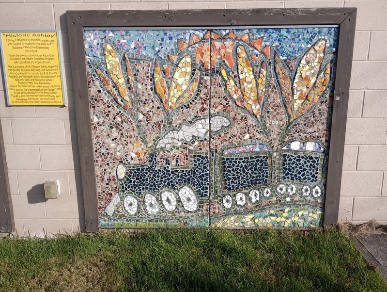
On South Main Street at East High Street (Ohio Route 229), on the right when traveling north on South Main Street.
A project designed by the third grade class, and created by students in grades K-4th, Buckeye Valley East Elementary 2013 - 2014.
Under the direction of art teacher Robin Clay as a part of the Artist-in-Residence Program with Lynda Elias and . . . — — Map (db m236808) HM
On Dublin Road (Ohio Route 257) at Bellpoint Road, on the right when traveling north on Dublin Road.
Bellpoint Buccaneers
In the early part of the twentieth century, most small villages in Ohio focused community pride on the accomplishments of their high school's athletic teams. The Bellpoint basketball teams of the 1920s were a great example. . . . — — Map (db m12812) HM
On Dublin Road (Ohio Route 257) at Front Street (County Route 150), on the right when traveling north on Dublin Road.
This plaque is set here
in memory of those people
from Concord Township who
served in the armed forces of
the United States of America
erected by
Concord Township Trustees — — Map (db m89534) WM
On Washington Street at Fountain Avenue, on the left when traveling north on Washington Street.
This was the first residence of movie director Vincente Minnelli when his family moved to Delaware. At that time Vincente was eleven years old, and the home belonged to his grandparents, Vince and Nina Minnelli.
Vincente credited pleasant . . . — — Map (db m18250) HM
On North Sandusky Street north of East William Street (U.S. 36), on the right when traveling north.
African-American Civil War soldiers lined on Sandusky Street in November of 1863. Having been trained at Camp Delaware one mile to the south, they were designated the 127th Ohio Volunteer Infantry and later the 5th United States Colored Troops. . . . — — Map (db m203312) HM
Near South Sandusky Street 0.1 miles north of Park Avenue, on the right when traveling north.
This sculpture recreates the dimensions of the back porch on the original Butler A. Jones House of Black Culture. This was a space of respite, socializing, and community for Black students at OWU. Back Porch is intended to serve as a new performance . . . — — Map (db m203315) HM
On South Henry Street 0.2 miles north of Wilmer Street, on the right when traveling north.
• Athlete, teacher, coach, lawyer, baseball legend, and humanitarian
• Credited with breaking the color barrier in Major League Baseball by signing Jackie Robinson
• Responsible for the formation of the All-American Women's Baseball League . . . — — Map (db m203330) HM
On Sandusky Street at Olentangy Avenue, on the right when traveling south on Sandusky Street.
Near this site, the Union army established two camps on either side of the Olentangy River during the Civil War. Both were known as Camp Delaware. The first camp, situated on the west side of the river in the summer of 1862, was where the white . . . — — Map (db m12816) HM
IN LOVING MEMORY
OF OUR FRIENDS
Douglas MacMillan Cherry '85
Ann Campana Judge '73
and
Edward Hobbs Luckett '84
who lost their lives September 11, 2001.
These gardens and benches are given in
their honor by The OWU Friends Fund . . . — — Map (db m224095) HM
On East Lincoln Avenue near Blymer Street, on the left when traveling east.
In the late days of September, 1776, negotiators William Wilson and Joseph Nicholson left Fort Pitt which is today Pittsburgh. Their goal was to convince the tribes north and west of the Ohio not to join forces with the British. For support, the . . . — — Map (db m93221) HM
On Central Avenue (Ohio Route 37), on the right when traveling west.
(Side A):
Courthouse Hill
In the early years of Delaware, this area was known as Briar Hill. It is the highest elevation in the city. Situated facing south and approximately at the center of the existing Courthouse, was the site of the first . . . — — Map (db m18247) HM
On Court Street at North Sandusky Street, on the right when traveling east on Court Street.
Korea
Dwight C. Adams •
Douglas N. Blair •
James H. Budd •
Donald E. Clark •
Charles L. Gordon •
Morgan B. Hansel •
Gerald L. Hansen •
Darvin A. Lillie •
Fred B. Lowe •
Harry L. Spearman
Vietnam
Norman R. . . . — — Map (db m203288) WM
On Sandusky Street, on the left when traveling north.
In memory of the soldiers and sailors of Delaware County, Ohio, who served in the War of 1861 to 1865 “Their heroic valor ensured our lasting peace” — — Map (db m18227) HM
On Sandusky Street, on the left when traveling north.
Dedicated by the people of Delaware County in memory of those who gave the ultimate sacrifice and those who are still fighting to keep us free. Sept 11 2001 - — — Map (db m18241) WM
On Sandusky Street, on the left when traveling north.
In Honored Memory of Our Heroes Who Gave Their Lives
Dedicated to the men and women of Delaware County who served their country in World War II 1941 - 1945 — — Map (db m18244) WM
On William Street at Columbus Pike (U.S. 23), on the right when traveling west on William Street.
Delaware County: Anti-Slavery Stronghold
A unique combintation of strong-principled religous communities, free black settlements, and tightly knit extended families fostered a wide-spread attitude of willful defiance that made Delaware one of . . . — — Map (db m12829) HM
Near South Sandusky Street just north of Spring Street, on the right when traveling north.
This storm net structure was developed as a student research project in cooperation with Ohio Wesleyan University, the City of Delaware Public Utilities Department, and StormX Water Systems. The purpose of this project is to determine if the . . . — — Map (db m203320) HM
On Sandusky Street, on the right when traveling north.
In Memoriam
This rock and these three flowering crab trees are placed here in loving memory of three Ohio Wesleyan University students, who died in an auto accident while attending a conference on Russian studies at Oberlin College on September . . . — — Map (db m12833) HM
On Sandusky Street at Park Avenue, on the right when traveling north on Sandusky Street.
Edwards Gymnasium
The gym was dedicated February 22, 1906. It is named in memory of OWU Trustee John Edwards whose initial gift made its construction possible. At the time of its completion it was considered the largest and finest basketball . . . — — Map (db m12854) HM
Built in 1833 as a health resort named the Mansion House Hotel, Elliott Hall is noted as Ohio's oldest collegiate Greek Revival building. The closure of the Bank of the United States and an economic panic in 1837 created nation-wide financial . . . — — Map (db m12822) HM
On North Sandusky Street north of Marysville Road (U.S. 36), on the left when traveling north.
Frederick Douglass, African-American orator and abolitionist, spoke here on June 6, 1856. His speech on the issue of slavery was delivered on the third floor known as Templar Hall. The cost of admission was 25 cents with all proceeds going to the . . . — — Map (db m203314) HM
On South Henry Street 0.2 miles north of Wilmer Street, on the right when traveling north.
• Instrumental in the early development of OWU athletics, particularly football
• Responsible for OWU's involvement in the Buckeye Athletic Conference (conference founder)
• OWU beat Michigan and Syracuse in football in 1928 under his . . . — — Map (db m203344) HM
On West Winter Street at Elizabeth Street, on the right when traveling west on West Winter Street.
George W. Campbell originally built this highly picturesque structure in 1854. Designed with Romanesque and Norman Revival architectural features - a round tower, arched windows and doorways - and constructed of locally mined blue limestone, the . . . — — Map (db m12817) HM
On South Sandusky Street at Spring Street, on the right when traveling north on South Sandusky Street.
Professor of psychology & Ohio Wesleyan's first director of information systems. A fierce proponent of the value of a liberal arts education & rigorous scientific inquiry. A respected friend to OWU, Roy is missed & remembered with love. — — Map (db m203318) HM
On South Henry Street 0.2 miles north of Wilmer Street, on the right when traveling north.
• Legend in collegiate soccer
• OWU gained national NCAA division III recognition in numerous sports during his tenure
• OWU recorded five national top 25 finishes in Sears Directors' Cup standings during his tenure
• Four NCAA . . . — — Map (db m203367) HM
On Olentangy River Road (Ohio Route 315) at Home Road, on the left when traveling north on Olentangy River Road.
Liberty Presbyterian Church
Founded in 1810
The first religious society organized in Liberty Township was formed in 1810 by Elders Thomas Cellar, Josiah McKinnie, and Leonard Monroe. Cellar and McKinnie came to Delaware in 1802. In 1820, The . . . — — Map (db m179476) HM
On South Henry Street 0.1 miles north of Wilmer Street, on the right when traveling north.
• Nationally renowned as a leader in the development of athletics
• After OWU, served for 35 years as director of athletics at the Ohio State University — — Map (db m203341) HM
On North Franklin Street just north of East William Street (U.S. 36).
In the mid-19th century
Mrs. Joan Hills Murray conducted
a school in this building.
Among her students was
Rutherford B. Hayes. although
generally known as
“Mrs. Murray’s School” this
edifice was originally built
for Sophia Moore in 1821 as . . . — — Map (db m228240) HM
On Sandusky Street, on the right when traveling south.
In 1850, this eighty acre tract known as the Kilbourne farm was purchased for use as a cemetery. The “Old Burial Grounds,” located where Ohio Wesleyan's Selby Stadium now stands, had deteriorated and most of those remains were removed to . . . — — Map (db m12851) HM
On Sandusky Street at William Street (U.S. 36), on the right when traveling north on Sandusky Street.
The old city hall opened in 1882. Its clock tower rose to a height of 92ft. The first floor housed administrative offices, the police department, the jail, and the fire department. A 1,050 seat auditorium known as the Opera House graced the second . . . — — Map (db m12852) HM
On Columbus Pike (U.S. 23) at the Delaware Golf Club entrance road, on the right when traveling north on Columbus Pike.
Pioneer Radio Telescope
One-half mile east is the site of the former BIG EAR radio telescope. Designed by Dr. John D. Kraus, pioneering radio astronomer at Ohio State University, it had a collecting area of 340 by 70 feet (104 by 21 meters). . . . — — Map (db m12813) HM
Near South Sandusky Street at Park Avenue, on the right when traveling north.
Ohio Wesleyan University was established in 1842, in one building (Elliot Hall) which at the time was located a short distance from the proposed location for the bioretention cell. Elliot was built near a sulphur spring, which flowed into the . . . — — Map (db m203316) HM
On East Williams Street (U.S. 36) east of North Sandusky Street. Reported permanently removed.
President
Hayes
Memorial
This tablet marks the birthplace
of
Rutherford B. Hayes
Nineteenth President of
The United States
Born October 4th, 1822
Placed by The Delaware City Chapter
Daughters of American Revolution . . . — — Map (db m241651) HM
On South Henry Street 0.2 miles north of Wilmer Street, on the right when traveling north.
• Legend in collegiate golf
• Longest tenure of any coach in any sport in OWU's history (39 years, 1954-93)
• Assistant to the president for athletics (1991-93)
• A founder of the North Coast Athletic Conference
• Instrumental in the . . . — — Map (db m203347) HM
On South Henry Street 0.2 miles north of Wilmer Street, on the right when traveling north.
• A leader in the Ohio Athletic Conference Administration
• Started and expanded many sports at OWU including soccer, wrestling, and lacrosse
• Started the OWU Athletic Hall of Fame (1961), instrumental in the inclusion of women (1976)
. . . — — Map (db m203346) HM
On West William Street (U.S. 36) at South Sandusky Street, on the left when traveling west on West William Street.
1817 • Rutherford and Sophia Hayes move to Delaware from Dummerston, Vermont
July 1822 • Rutherford Hayes dies from a fever
October 4, 1822 • Rutherford Birchard Hayes is born in the family home at 17 East William Street
1823 • The Hayes . . . — — Map (db m239852) HM
On East William Street (U.S. 36) east of North Sandusky Street, on the right when traveling west.
At this site on October 4, 1822, Rutherford B. Hayes was born to Sophia Hayes. Hayes’ father, Rutherford, had passed away from a fever three months prior to the birth of his son. The Hayes family were renters on the property, originally owned by . . . — — Map (db m277693) HM
On Marysville Rd (U.S. 36), on the left when traveling west.
The McClure Road or Wilderness Way crossed
a permanent stream at this point. An “S”
bridge has been placed here for utility, flood
and wash control. Originally the bridge
consisted of large granite boulders as buttress
walls, over . . . — — Map (db m89680) HM
On Marysville Rd (U.S. 36), on the left when traveling west.
The Atkinson Farm was located at this location since the McClure Road
ran by this site approximately 500 feet north of here. The holding had
ready access to a main road and was not hampered by being isolated deep
in the fields as it is today. The . . . — — Map (db m89681) HM
On Marysville Rd (U.S. 36), on the left when traveling west.
Passing this point in the eighteen hundreds
was a major road. It was a more direct route
from Delaware than the more indirect #36 to
this point. Here it was a four corner crossing
the Atkinson Lane and the lane leading north to
one of the . . . — — Map (db m89682) HM
On Marysville Rd (U.S. 36), on the left when traveling west.
From the early 1800’s until the early
1900’s a stagecoach road, coming
directly from Delaware, passed this
point on it’s way to (Millville)
Warrensburg, Marysville and Prospect.
It was closed by the property holders
(the McClure Family) as . . . — — Map (db m89683) HM
On East Lincoln Avenue east of Blymer Street, on the left when traveling east.
Near this location was a large Mingo town of significance during the Revolutionary period of the 1770's. The chief was Te-caugh-ye-te-righ-to, known to the settlers as Pluggy. The village consisted of perhaps 300 inhabitants. Among them were . . . — — Map (db m93220) HM
Near South Henry Street south of East William Street (U.S. 36), on the right when traveling south.
On the morning of May 3, 1890, Ohio Wesleyan University and The Ohio State University met at this location for a football game. It was the first game in Ohio State football history. Ohio Wesleyan had invited the newly organized team to a contest as . . . — — Map (db m18316) HM
On West Winter Street west of North Franklin Street, on the left when traveling west.
On May 9, 1817, an Instrument of Parochial Association to form
St. Peter’s Episcopal Church was signed by eleven prominent
citizens of Delaware, Ohio. In 1824, Bishop Philander Chase of
the newly-formed Diocese of Ohio provided a wooden model . . . — — Map (db m228242) HM
Near Pensylvania Avenue at Berne Street, on the right when traveling west.
Side A The Delaware County Fairground June 28, 1833 a meeting of the citizens of Delaware County convened under an act of the Ohio Legislature to establish The Delaware County Agricultural Society. Officers were elected with Milo Pettibone . . . — — Map (db m18301) HM
On Columbus Pike (U.S. 23) just north of Orange Point Drive, on the left when traveling north.
The Gooding House and Tavern
Known as the "Halfway House," the Gooding House and Tavern was built by George B. Gooding halfway between the towns of Worthington and Delaware in 1827. Its location was influenced by construction of the Columbus . . . — — Map (db m12824) HM
Site of Pioneer Tavern
Headquarters of
General
William Henry Harrison
on the march from
Franklinton to Sandusky
February 1813 — — Map (db m155950) HM WM
On William Street (U.S. 36) at Columbus Pike (U.S. 23), on the left when traveling east on William Street.
The rain swollen Olentangy River flowed seven feet
above the William Street Bridge during the March
1913 flood, the greatest natural disaster in Ohio
history. Statewide, the flood claimed 428 lives and
destroyed more than 20,000 homes. In . . . — — Map (db m89362) HM
Ohio Wesleyan owes its location to the initial efforts to establish a resort for healing purposes on the site of the Sulphur Spring. When the business faltered, Adam Poe, a pastor and several citizens purchased it and gave it to the Methodists for a . . . — — Map (db m18313) HM
Near South Sandusky Street at Spring Street, on the right when traveling north.
This tablet and beech tree
Gifts of Ohio Wesleyan Monnett Clubs, commemorate the work of Rev. Joseph H. Creighton Ohio Conference who in 1872 planted the campus arboretum
Prof. Asa Gray, Harvard, his friend presented many trees now adorning the . . . — — Map (db m224096) HM
University Hall was completed in 1893. It is constructed of Amherst Sandstone. The bell tower rises to a height of 148 feet. The structure houses administrative offices, classrooms, and the legendary Gray Chapel. Among the celebrities who have . . . — — Map (db m12845) HM
On South Sandusky Street at Weiser Avenue, on the right when traveling south on South Sandusky Street.
Beneath this sod, lie the remains
of fifteen black Union army soldiers
of the United States Civil War,
who shall forever remain unknown
to all, but God.
These honored dead,
once known but to God,
are now revealed to mankind.
2 Lt . . . — — Map (db m297995) WM
On Sandusky Street, on the left when traveling north.
In recognition of the patriotism of the people of Delaware County who oversubscribed their War Saving Quota in 1918 this tablet is gratefully erected by the Ohio War Savings Committee — — Map (db m18239) HM
Near South Sandusky Street at Spring Street, on the right when traveling north.
The labyrinth is an ancient circular pattern found in many cultures dating back over 5000 years. This design is a replica of the medieval 11-circuit labyrinth embedded in the floor of Chartres Cathedral in France. A single path winds to the . . . — — Map (db m203319) HM
On West Willam Street (Marysville Road) (U.S. 36) at North Franklin Street, on the right when traveling west on West Willam Street (Marysville Road).
William Street United Methodist Church.
The first Methodist class in Delaware was organized
in 1818, later to become William Street United
Methodist Church. The first church building was
dedicated in 1824 directly across N. Franklin . . . — — Map (db m169863) HM
On Washington Street at Bernard Avenue, on the right when traveling south on Washington Street.
Organized in 1845, Zion African Methodist Episcopal Church is the oldest congregation of African descent in Delaware, with Reverend Daniel Winslow serving as the first minister. In 1853 the cornerstone of the first church was laid, which was . . . — — Map (db m12823) HM
Near Warrensburg Road (County Road 172) 0.5 miles west of South Section Line Road (County Road 5), on the right when traveling east.
The Troedrhiwdalar Welsh Congregational Church was organized by Reverend Rees Powell in 1839 for the Welsh pioneers in the southern part of Radnor Township. The first meeting house was built of logs in 1842. Membership grew quickly and the log . . . — — Map (db m246856) HM
On Riverside Drive (Ohio Route 257) at Glick Road, on the right when traveling south on Riverside Drive.
Australian Government Response
This program is the official response to the threat of extinction of the Tasmanian devil due to Devil Facial Tumour Disease (DFTD).
Program Vision...
an enduring and ecologically functional population . . . — — Map (db m310484) HM
On Gorsuch Road (Local Route 27) east of Miller-Paul Road (Local Route 18), on the right when traveling east.
Benajah Cook and the families who settled in Harlem
Township, Delaware County are honored for creating
a community of productive farms. The Benajah
and Cassandra Cook family arrived when the land
was forested and settled on 500 acres of the . . . — — Map (db m117443) HM
On Park Street at Middle Street, on the right when traveling west on Park Street.
David Bricker, Lee Fetherole, Vincent Linkekugel, Andrew McFarland, Jr., and George J. Phillips were indicated as having died while in service. further names were not transcribed. — — Map (db m134146) WM
On Front Street, on the left when traveling south.
Galena sits at the confluence of Big Walnut and Little Walnut Creeks. The village square was once surrounded on all four sides by buildings and commercial properties on stilts once lined the Big Walnut Creek.
Because Columbus considered them . . . — — Map (db m133589) HM
On Cheshire Road at Old State Road/Lackey Old State Road, on the right when traveling west on Cheshire Road.
Berlin School stood on this site from 1915 to 1975. The first graduating class was in 1916, with the first graduate being Mildred Schanck. The last graduating class was in 1953 with 14 members. Over these 38 years, 472 students graduated from . . . — — Map (db m20554) HM
On Fancher Road 1 mile west of New Albany-Condit Road ( Route 605), on the right when traveling west.
Tunes played on fife and drum regulated a soldier's life in camp and
his actions on the battlefield. Heard over the roar of battle and through
the haze of smoke, fifes and drums - field music - communicated orders
to massed troops quickly. . . . — — Map (db m142587) HM
On Fancher Road at Schleppi Road, on the right when traveling west on Fancher Road.
On land owned by the William Fancher family (1810). Earliest burial 1822; currently active cemetery.
The oldest of three sections is closest to Fancher Road. Burial location of many veterans from the Revolutionary War to the present. Cemetery . . . — — Map (db m297986) HM
On Fancher Road at Schleppi Road, on the right when traveling east on Fancher Road.
Established on land owned by R.J. Kern. Earliest burial appears to be 1900. North and South sections; currently active cemetery. Burial location of many veterans from the Civil War to the present. Cemetery and records maintained by Harlem . . . — — Map (db m297987) HM
On Hyatts Road 0.1 miles east of Steitz Road, on the right when traveling east.
In 1985, Hindu immigrants from India formed a celestial organization, The Bharatiya Temple Society of Central Ohio, and through its membership adopted the Constitution and Bylaws and named the place of worship Bharatiya Hindu Temple. Later they . . . — — Map (db m12819) HM
Near Kilbourne Road (Ohio Route 521) 0.1 miles west of Main Street, on the left when traveling east.
In Memorium Paul Leonard Killed In Action World War I Original Planting 1916 Replaced 2019
In Memorium Lloyd Sheets Killed In Action World War I Original Planting 1916 Replaced 2019
In Memorium Lynn Sheets Killed In . . . — — Map (db m239837) WM
On Ohio Route 521, on the left when traveling east.
This bell hung in the Eden Methodist Episcopal Church from 1908 - 1968. The old church was located on Lot 40, near this site. The bell was in active use from its installation in 1908 until 1940 when its use was discontinued due to structural . . . — — Map (db m236801) HM
On State Route 521, on the left when traveling east.
This acorn was on the top of the arch at the front entrance to Brown School. The school was built in 1915. The acorn and the brick columns in front were original to the school. — — Map (db m236805) HM
On State Route 521, on the left when traveling east.
Former Site of Brown Township School
1915 - 2010
1915 School Board A. Humes • J. Wornstaff • H. Cowgill • C. Sheets • F. Plunkett • Wes Ott, Clerk Presented To Brown Township Loyalty Song We're loyal to you Brown Hi
For we . . . — — Map (db m236803) HM
On South Old State Road (County Route 10) at Ashcreek Avenue, on the right when traveling north on South Old State Road.
First Jain Temple in Central Ohio. “Souls render service to one another”. The Jain Center of Central Ohio was established on May 12, 1991. The foundation stone of the Jain temple, the first of its kind in Central Ohio, was laid . . . — — Map (db m105528) HM
Marker Front:
James Kilbourne
and
The Columbus and Sandusky Turnpike
James Kilbourne, an Ohio pioneer who led settlers to the Worthington area in 1803, was born in Connecticut in 1770 and died in Ohio in 1850. In 1805 he was . . . — — Map (db m18251) HM
A convoy of 3 ships and 3 Coast Guard cutters passed through “Torpedo Alley” some 100 miles off the coast of Greenland at about 1 a.m. on February 3, 1943. The submarine U-223 fired 3 torpedoes 1 of which hit the midsection of the . . . — — Map (db m18207) HM WM
Near Lewis Center Road 0.2 miles west of Africa Road, on the right.
Samuel Patterson arrived in East Orange in 1824 and, within a few years, began to hide runaway slaves in his home. He also invited anti-slavery speakers to the pulpit of the East Orange Methodist Church, which brought Patterson and his neighbors . . . — — Map (db m20550) HM
On Old State Road (County Route 10) at Orange Road, on the right when traveling north on Old State Road.
[Armed Services Flags and Emblems]
"This will remain the land of the free
so long as it is the home of the brave."
Elmer Davis
"For love of country they accepted death,
and thus resolved all doubts, and made immortal
their . . . — — Map (db m303071) WM
On Dean Road (County Route 157) at Second Street, on the right when traveling west on Dean Road.
On this site was located the
town pump which was the main
source of water for the village
during the early 1900’s and used
by residents until 1973. — — Map (db m89535) HM
In memory of all Veterans of the
Ostrander area who honorably
served or paid the
supreme sacrifice in
defense of this country.
Dedicated May 29, 1995
donated by Ostrander Senior Citizens
(six logos) — — Map (db m89536) WM
On Riverside Drive (Ohio Route 257) at Glick Road, on the right when traveling south on Riverside Drive.
The magic of the 20th century's Golden Age of Carousels has been recaptured in the restoration of this unique Columbus jewel. Together let's celebrate the treasure and invite children of all ages to experience the wonder of the carousel - the beauty . . . — — Map (db m310519) HM
On West Powell Road (Route 750) at West Olentangy Street, on the right when traveling south on West Powell Road.
Habitat Forests near waterways, wetlands, and coastlines
Nutrition Fish, small mammals, birds, and carrion (animal remains)
Conservation Status Least Concern
Back from the Brink
By 1963, bald eagle . . . — — Map (db m309483) HM
On West Powell Road (Route 750) at West Olentangy Street, on the right when traveling south on West Powell Road.
Habitat Forests near waterways, wetlands, and coastlines
Nutrition Fish, small mammals, birds, and carrion (animal remains)
Conservation Status Least Concern
Back from the Brink
By 1963, bald eagle . . . — — Map (db m309484) HM
1670 entries matched your criteria. The first 100 are listed above. Next 100 ⊳