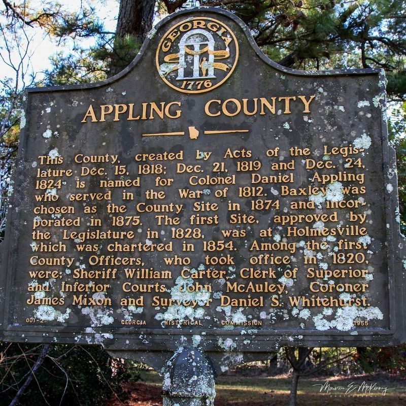
On Post Road at South Main Street (U.S. 1), on the right when traveling west on Post Road.
This County, created by Acts of the Legislature Dec. 15, 1818; Dec. 21, 1819 and Dec. 24, 1824 is named for Colonel Daniel Appling who served in the War of 1812. Baxley was chosen as the County Site in 1874 and incorporated in 1875. The first Site, . . . — — Map (db m156561) HM
On Golden Isles Highway (U.S. 341) at South Oak Street, on the right when traveling east on Golden Isles Highway.
Baxley's Caroline Pafford Miller (1903-1992) was the first Georgia novelist to be awarded the Pulitzer Prize for Literature. The author was born in Waycross and spent her formative years in the South Georgia wiregrass country. After moving to . . . — — Map (db m10079) HM
On South Main Street (U.S. 441) at West Smith Avenue, on the right when traveling south on South Main Street.
Atkinson County was created by an act of the Georgia legislature in 1917, out of lands previously in Clinch and Coffee Counties.
The county was organized Jan. 1, 1918. The first officers were J.W. Roberts, Ordinary; Wiley M. Sumner, Clerk . . . — — Map (db m106274) HM
On U.S. 221 at Kinnaird Trail (County Road 29), on the right when traveling south on U.S. 221.
Kinnaird Trail, considered the oldest public road in Wiregrass Georgia, follows an Indian trail used before white men came to this country. In Revolutionary days, it was named Kinnaird Trail as the route was used by Indians and traders travelling . . . — — Map (db m26019) HM
On East Carter Avenue at North Church Street, on the left when traveling east on East Carter Avenue.
Here, about 1873, on Lot No. 1, S.J. Henderson built the first residence in Pearson, then the terminus of the Brunswick and Albany R. R. Successively the home of prominent families in early Pearson history, in 1905 it became the residence of Martin . . . — — Map (db m53174) HM
On Salem Church Road (County Route 29) 0.5 miles east of U.S. 221, on the left when traveling east.
Salem Church was built in 1889 on the Kinnaird Trail -– an Indian pathway that later became a stagecoach relay station. Martin S. Corbett was born here on 5-12-1840 and married cousin, Leonora Wealtha Pafford on 11-26-1867. Their home was . . . — — Map (db m53290) HM
On South Pierce Street (U.S. 1/23) 0.4 miles south of Williams Avenue, on the right when traveling north.
Welcome to Alma — Bacon County, Georgia Home of Congressional Medal of Honor Recipient 2nd Lt. Daniel Warnell Lee, Sr. Awarded January 23, 1946 — — Map (db m245985) WM
On Dixon Street (State Highway 4) at East 12th Street, on the right when traveling south on Dixon Street.
This County, created by Act of the Legislature July 27, 1914, is named for Augustus O. Bacon, four times U.S. Senator, who died in office Feb. 15, 1914. An expert on Mexican affairs, his death was a great loss coming at a time of critical relations . . . — — Map (db m24292) HM
On Georgia Route 37 at Clear Lake Road (County Route 121), on the right when traveling north on Georgia Route 37.
Near here in Chickasawachee Swamp a decisive battle of the Southern Indian Wars was fought July 3, 1836. About 300 warriors were entrenched on an island in the swamp, after a raid in which they killed several settlers. A force of militia under . . . — — Map (db m218683) HM
Near Millford Church Road 0.3 miles north of Route 216, on the left when traveling north.
Milford Baptist Church stood on this site for more than 120 years from about 1880 until February 2002. These rocks served as pillars for that building just as Milford Baptist Church has been the foundation of this community since 1834. The . . . — — Map (db m218688) HM
On Main Street at Court Avenue, on the right when traveling north on Main Street.
This County, created by Acts of the Legislature Dec. 12 & 24, 1825, is named for Col. John Baker of Revolutionary fame. The original County Site was at Byron but an Act of Dec. 26, 1831, established a new Site which was named Newton for Sgt. John . . . — — Map (db m26981) HM
On South Sheridan Street south of East Central Avenue (U.S. 319), on the right when traveling north.
Ben Hill County, created by Act of July 31, 1906 from Irwin and Wilcox Counties, was named for Benjamin Harvey Hill (1823-1882), “one of America’s greatest orators.” A staunch supporter of the administration in the Confederate Senate, after the War . . . — — Map (db m40263) HM
On West Central Avenue (U.S. 319) at Main Street, in the median on West Central Avenue.
“You triumphed over obstacles which would have overcome men less brave and determined”
President McKinley
(On base of soldier):
Hiker of ‘98
Dedicated to the Veterans of 1898 -1902
By the Camps and Auxiliaries . . . — — Map (db m62952) WM
On Merrimac Drive at Jessamine Street, on the left when traveling south on Merrimac Drive.
This bell was awarded to the First Baptist Church by Governor William J. Northen (1833-1913) to honor the first church built in the Colony City of Fitzgerald. Governor Northen was an outstanding Baptist layman who graduated from Mercer University at . . . — — Map (db m11705) HM
On West Central Avenue (U.S. 319) at North Grant Street (U.S. 129), in the median on West Central Avenue.
Founded at Swan in 1895 by Mr. Philander H. Fitzgerald, lawyer, veteran and publisher of the AMERICAN TRIBUNE of Indianapolis, as a soldiers’ colony in the South. Fitzgerald was settled by Union veterans who, tired of Northern winters, flocked from . . . — — Map (db m40377) HM
On East Pine Street at South Main Street, on the right when traveling east on East Pine Street.
The Rotary Club of Fitzgerald was chartered on December 21, 1936, through the sponsorship of the Columbus Rotary Club. The organizational meeting was held December 1, 1936 in the office of J. C. McDonald. There were twenty-six charter members. S. . . . — — Map (db m191137) HM
On West Suwanee Street 0 miles west of North Gordon Street, on the left when traveling west.
This was the home of General William Jordan Bush, last survivor of the 125,000 heroes from Georgia who fought for the South. Gen. Bush was born near Gordon, Ga. July 10, 1845, and died here Nov. 11, 1952. In the War Between the States he was a . . . — — Map (db m40168) HM
On West Central Avenue (U.S. 319) at Grant Street (U.S. 129), in the median on West Central Avenue.
On May 4, 1865, Jefferson Davis arrived in Washington, Georgia (178 miles NE of the Park), where he performed his last duties as President of the Confederate States of America. Shortly thereafter, with a small staff and escort, he departed enroute . . . — — Map (db m40378) HM
On Bethlehem Church Road 0.1 miles south of Broom Road, on the left when traveling south.
Ozias Primitive Baptist Church was constituted July 14, 1832. Elders Wilson Conner and John Martial were the Presbytery. Members were John McDonald, Randall McDonald, Elijah Hunter, Penelope Hunter, Catherine McCall, Mary McDonald, Elizabeth . . . — — Map (db m57153) HM
On East Pine Street just east of South Sheridan Street, on the right when traveling west.
This historical portable confinement cage was purchased by Ben Hill County from Manly Steel in the year 1913 for the purpose of transporting and housing the chain gang convicts while working on county roads. — — Map (db m164784) HM
On North Railroad Street just east of North Davis Street (U.S. 129), on the left when traveling east.
Original bank building est. 1905 Occupied by bank until 1917 When the new office was built later known as Alapaha Post Office Building Renovated and dedicated by Bank of Alapaha – 2016 — — Map (db m191175) HM
On North Davis Street (U.S. 129) at West Marion Avenue, on the left when traveling south on North Davis Street.
Following the United States' entry into World War I (1917-1918), more than 100,000 Georgians were involved in the war effort, with the state suffering over 1,000 casualties. The rural community of Berrien County experienced an extraordinary high . . . — — Map (db m175073) HM
On South Davis Street (U.S. 129) at East Washington Avenue, on the right when traveling north on South Davis Street.
Berrien County, created by Act of Feb. 25, 1856, was named for John MacPherson Berrien, “the American Cicero,” who was born Aug. 23, 1781 and died Jan. 1, 1856. He was Judge of the Eastern Circuit, U.S. Senator and U.S. Attorney General. The county . . . — — Map (db m40122) HM
On West Washington Avenue at South Davis Street ( Route 76/125), on the right when traveling west on West Washington Avenue.
Dedicated to the honor and in memory
of the patriotic men and women from
Berrien County who gallantly served
their country during World War II.
Without their bravery, we would not
have maintained a nation created by
God with freedom and . . . — — Map (db m267222) WM
On North Main Street (U.S. 129) at Flat Creek Church Road, on the left when traveling north on North Main Street. Reported missing.
Flat Creek Mills was a trading post and election precinct many years before the present Berrien County was created in 1856. Officers of the new county were sworn in here, and there being no court house, the first Inferior Court was held here in the . . . — — Map (db m50534) HM
Near South Bartow Street at Johnson Alley, on the left when traveling north.
has been placed on the National Register of Historic Places by the United States Department of the Interior on January 30, 1995 — — Map (db m164639) HM
On South Davis Street (U.S. 129) at East Washington Street, on the right when traveling north on South Davis Street.
In the summer of 1836, a company of militia under Capt. Levi J. Knight of near Ray City was sent to protect the settlers from marauding Indians on their way to join the Seminoles in Florida. When a party of Indians plundered the plantation of . . . — — Map (db m40123) HM
On Jefferson Street near West Washington Avenue, on the right when traveling south.
(center panel)
In memory of the Korean War Veterans from Berrien County
(left panel)
Baldree,Thomas •
Bennett, Joseph •
Bennett, Kenneth •
Blanton, Charlie •
Blanton, Talmadge •
Blount, Henry •
Boyd, Robert . . . — — Map (db m267224) WM
On North Davis Street (U.S. 129) at East Marion Street ( Route 76), on the right when traveling north on North Davis Street.
The Old Coffee Road, earliest vehicular and postal route of this section, running southwestward from the Ocmulgee River to the Florida Line, passed through today’s Lax, Nashville, Cecil, Barwick and Thomasville. The thoroughfare was opened by . . . — — Map (db m40124) HM
On Jefferson Street just south of East Marion Avenue (State Route 76), on the right when traveling south.
[east]This monument is erected in honor and memory of all Confederate soldiers who defended our constitutional freedoms. [north]C.S.A. President Jefferson Davis C.S.A. Vice-President Alexander H. Stephens Georgia Governor Joseph E. . . . — — Map (db m164797) WM
On South Davis Street (Georgia Route 76/125) at West Washington Avenue, on the left when traveling south on South Davis Street.
(center panel)
Dedicated to the men that served in the Southeast Asian War, and to all servicemen that supported their fight for freedom.
James E Jones
USA • SMAJ
Laos • 10-03-66
5th Special Forces
Prisoner Of War . . . — — Map (db m267220) WM
This County, created by an act of the Georgia Legislature
July 30, 1912, is named for Chief Justice Logan E. Bleckley, of
the Georgia Supreme Court, one of the greatest jurists in the
history of this State. Born in Rabun County in 1827, he . . . — — Map (db m47553) HM
On North Second Street at East Dykes Street ( Road 26/112), on the right when traveling north on North Second Street.
City of Cochran was chartered
on March 19, 1869.
Cochran is named for
Judge Arthur E. Cochran (1820-1865)
who served as a State Legislator
and as President of the
Macon & Brunswick Railroad. — — Map (db m197982) HM
On North Second Street at East Dykes Street ( Road 26/112) on North Second Street.
(Side A)
In memory of
our
Confederate
soldiers
(Side B)
Erected by the
Cochran Chapter
No. 764 U.D.C.
to the
Confederate veterans
of Pulaski County, 1910
“When the last trumpet
is sounded, may each one . . . — — Map (db m197980) WM
On North Second Street at East Dykes Street ( Road 26/112), on the right when traveling north on North Second Street.
First settled as the community of Dykesboro in the 1830s, the City of Cochran was incorporated in 1869. The town was named after Judge Arthur E. Cochran, a prominent figure in local justice and railroad affairs, and founded on land donated by early . . . — — Map (db m197970) HM
On North 2nd Street (Business U.S. 23) 0 miles east of Cherry Street, on the left when traveling east.
Beloved lifelong citizen of Cochran and Bleckley County, he was a banker, farmer, mayor, Rotarian, Mason, Shriner and a never failing friend to all. His example to do all men good helped shape the lives and destiny of this county. His Christian . . . — — Map (db m57925) HM
On Golden Isles Highway (U.S. 23) 0.3 miles north of Coley Station Road ( Route 112), on the right when traveling north.
Evergreen Baptist Church, built in 1844, was split off from old Mt. Horeb Baptist Church, constituted October 15, 1809, which stood at or near the site of the Centenary Methodist Church. On February 14, 1844, the congregation and pastor found . . . — — Map (db m40312) HM
On North 2nd Street (Business U.S. 23) 0 miles east of Cherry Street, on the left when traveling east.
July 21, 1908 – October 8, 1986
In memory of Perry L. Johnson, of Bleckley County, Georgia who at age 36 while serving as a Corporal in the United States Army during WW II, single handedly captured fifteen German soldiers at St. Malo, . . . — — Map (db m57624) HM
On Longstreet Church Road 0.5 miles south of Broadhead Road, on the left when traveling north.
Longstreet Methodist Church was organized around 1812 and the original building is still in use. Land for the church was given by Charles Walker, one of the five sons of George Walker, Revolutionary soldier and early settler. The sons built on a . . . — — Map (db m40313) HM
On North 2nd Street (Business U.S. 23) 0 miles east of Cherry Street, on the left when traveling east.
Attorney, Statesman, and Educator of Cochran, Bleckley County, for more than seventy years. This plaque is erected to commemorate the 100th birthday of Col. Whipple and his contributions to this community. — — Map (db m57948) HM
On North 2nd Street (Business U.S. 23) 0 miles east of Cherry Street, on the left when traveling east.
In Memory of Sgt. John F. Conner, Sr.
Who gave his life in line of duty.
“Greater love hath no man than this that a man lay down his life for his friends.”
St. John 15:13 — — Map (db m57947) HM
On Dykes Street SE (Georgia Route 26) north of 8th Street SE, on the right when traveling north.
This highway coincides closely with a segment of a noted east-west Indian route called the Lower Uchee Path. Beginning at Old Town on the Ogeechee, the trail led this way by Carr’s Shoals, on the Oconee, above Dublin, thence via Cochran, . . . — — Map (db m40267) HM
On U.S. 82 0.4 miles west of Petty Crossing Road, on the right when traveling east.
This ridge, interrupted only by major streams, extends south from the Altamaha River in Georgia to the Santa Fe River in Florida, a distance of 130 miles. It is an ancient barrier beach formerly many miles off-shore in the sea which covered this . . . — — Map (db m12423) HM
On Main Street (U.S. 301) near Brantley Street, on the right when traveling north.
This County, created by Act of the Legislature Aug. 14, 1920, is named for Benjamin D. Brantley. It is said that the old B. & W. Railroad, which was partly destroyed, marked the most southern point of advance of Sherman's Army. Among the first . . . — — Map (db m24045) HM
On 1st Avenue 0.1 miles south of Strickland Road, on the right when traveling south.
Barney Colored Elementary School was part of the Rosenwald school building program that matched funds from philanthropist Julius Rosenwaid with community donations to build rural Southern schools during the era of segregation. An example of a . . . — — Map (db m234828) HM
On Beasley Road (County Route 79) 0 miles Grooverville Road (County Route 275), on the left when traveling north.
This church had its beginning in 1832, on the plantation of William H. Ramsey, about 4½ miles Southwest of here. There being no Methodist services in the vicinity at the time he and his family moved to this area. Mr. Ramsey built a brush-arbor . . . — — Map (db m10025) HM
Near Liberty Church Road (County Route 94) 0 miles north of Grooverville Road (County Route 275), on the right when traveling west.
Between 1837 - 1841 the Baptists in this section were stirred on Missions, Sunday Schools and ministerial support. In 1841 the Ocklochnee anti-Missionary Baptist Assn. passed a ruling to dismiss members believing in the “new fangled . . . — — Map (db m10172) HM
On Campground Road 0 miles east of Adel Highway ( Route 76), on the left when traveling south.
The first Camp Meeting was held on this site in 1828 by a "few scattered Methodists" before any Methodist Church in the area was organized. William Hendry, William Blair and Hamilton W. Sharpe, as a committee, selected the site. Rev. Adam Wyrick was . . . — — Map (db m14761) HM
On Adel Highway (Georgia Route 76) at Coffee Road, on the right when traveling north on Adel Highway.
The Old Coffee Road, first vehicular and postal route of this area, passed here running southwestward from the Ocmulgee River via today's Lax, Nashville, Cecil, Barwick, and Thomasville to the Florida line above Tallahassee. The thoroughfare was . . . — — Map (db m14751) HM
On 2nd Street just north of Main Street, on the right when traveling north.
Home schooling prevailed in Morven District among early families. After 1865, small academies were supported by private means, with limited public funds. Morven Academy, founded by Dr. Robert Hitch, had local and boarding students for twenty years. . . . — — Map (db m164634) HM
On Radford Road (County Route 114) 0.8 miles west of Madison Highway ( Route 333), on the left when traveling west.
Columbia Primitive Baptist Church was formally constituted on the first Sunday in October, 1833, after serving as an arm of Bethany Church more than a year. Moses Dees was the first delegate from Columbia to the annual meeting of the mother church, . . . — — Map (db m14749) HM
On Bethel Church Road 1.5 miles south of Route 122, on the left when traveling south.
Bethel Primitive Baptist Church, the second Baptist Church to be organized in the area of old Lowndes County, was constituted September 2, 1826. The
organizing Presbytery were: Elders Benjamin Manning. Matthew Albritton and Henry Melton, with . . . — — Map (db m51514) HM
On Bethlehem Church Road at Grooverville Road, on the left when traveling south on Bethlehem Church Road.
Bethlehem Primitive Baptist Church about 4 miles Southwest of here, was constituted November 29, 1834. The charter members included: William T.
Rushing, his wife, Belinda; Asa Geiger, his wife, Nancy; William Jones, his wife, Elizabeth; James . . . — — Map (db m14747) HM
On East Screven Street (U.S. 84) at South Court Street (U.S. 221), on the right when traveling west on East Screven Street.
This county created by Act of the Legislature Dec. 11, 1858, is named for Preston Smith Brooks, zealous defender of States Rights. Born in S.C. Aug. 6, 1819, Brooks served in the Mexican War & in Congress. He died June 27, 1857. The first County . . . — — Map (db m26977) HM
On South Court Street (U.S. 221) at West Screven Street (U.S. 84), on the right when traveling south on South Court Street.
In August 1864, during the American Civil War, four men were executed in Brooks County, Georgia, for conspiring to plot a slave insurrection. The conspirators – led by a local white man, John Vickery, and three slaves named Nelson, George, and . . . — — Map (db m40368) HM
On Moultrie Highway (Georgia Route 333) at Coffee Road, on the left when traveling south on Moultrie Highway.
The Old Coffee Road, earliest vehicular and postal route of this area, crossed here, leading southwestward from the Ocmulgee River via today's Lax,
Nashville, Cecil, Barwick and Thomasville to the Florida Line. The thoroughfare was opened by . . . — — Map (db m14763) HM
On E. Screven Street at S. Court Street, on the right when traveling west on E. Screven Street.
To Those Who Gave Much. To Those Who Gave All
Quitman and Brooks County Dedicates This Memorial
November 11, 1921
Erected by Quitman Chapter
United Daughters of The Confederacy
1st Lt. Wilbur Oglesby
Privates
Arthur Culpepper · . . . — — Map (db m102345) WM
On Thomasville Road (U.S. 84) 0 miles west of South Laurel Street, on the right when traveling east.
In this cemetery, during the last year of the War Between the States, a number of Confederate soldiers, 17 of them unknown, were buried. Memorial services for these soldiers were held as early as 1869. In 1871, on Memorial Day, April 26, a group of . . . — — Map (db m26978) HM
On Nov. 15, 1864, after destroying Atlanta and cutting his communications with the North, Maj. Gen. W. T. Sherman, USA, began his destructive Campaign for Savannah -- the March to the Sea. He divided his army [US] into two wings. The Left Wing (14th . . . — — Map (db m11957) HM
On U.S. 80 near U.S. 280, on the right when traveling south.
The highway northward is the Old River Road, one of the earliest routes west of the Ogeechee and a leading way from Savannah to Georgia's western frontier. It followed an old Indian trial [sic] along the Ogeechee to a point west of Bartow, . . . — — Map (db m12474) HM
On U.S. 280 at Black Creek Church Road, on the left when traveling south on U.S. 280.
On Dec. 6, 1864, the 15th Corps (US), the extreme right of Gen. Sherman's army on its destructive March to the Sea, camped near Jenk's Bridge on Great Ogeechee River, east of Blitchton. On the 7th, Oliver's brigade was sent in advance of Hazen's . . . — — Map (db m11939) HM
On Belfast-Keller Rd, on the left when traveling west.
This church, the oldest congregation in lower Bryan County, was certified by the Presbytery of Georgia in 1830. Its founders included rice planters on Bryan Neck, among them Thomas Savage Clay, Richard James Arnold and George Washington McAllister. . . . — — Map (db m18648) HM
On South College Street (Georgia Route 67) near Courthouse Street, on the right when traveling north.
This County created by Act of the Legislature Dec. 19, 1793, is named for Jonathan Bryan, Revolutionary patriot and member of the Executive Council in 1777. The "lost town" of Hardwick on the Ogeechee River was the first temporary County Site. Laid . . . — — Map (db m14952) HM
On W. Gibson St. at S. College St., on the right when traveling east on W. Gibson St..
Built in 1912, this structure was originally
a simple one-room brick cube with barred
windows and an armored door. It was used
to house offenders for short periods for
fighting, public drunkenness and similar
minor offenses.
In 1928, the . . . — — Map (db m15816) HM
On Ford Avenue (State Highway 144) at Coastal Highway (U.S. 17), on the right when traveling east on Ford Avenue.
On May 10, 1754 GEORGE TOWN was established at the "Elbow" of Great Ogeechee River, eight miles east. In February, 1755, Gov. Reynolds, dissatisfied with Savannah as a capital and as a port, chose this new site because it has a . . . — — Map (db m8364) HM
In memory of
Antonio J. Waring, Jr. M.D.
1915 - 1964
This plaque erected by his admirers
in recognition of his memorable work
in Archaeology
and the field of Indian Civilization
and in appreciation of his devoted . . . — — Map (db m250488) HM
On Bryan Neck Road (Georgia Route 144) at Carver School Road, on the left when traveling south on Bryan Neck Road.
Organized in 1869, this is the oldest African-American church congregation in lower Bryan County. The first structure for the church, a Prayer House, was built in 1870 on this site near the white Presbyterian Church (Burnt Church). London Harris, a . . . — — Map (db m54193) HM
On Bryan Neck Road (Georgia Route 144) 0.1 miles south of Belfast River Road, on the right when traveling south.
Near this site in 1830 the Bryan Neck Presbyterian Church was established, being the oldest organized congregation in Bryan County. The church served the numerous planter families of lower Bryan, which had become one of the most productive . . . — — Map (db m54354) HM
Built by William Collyer in New York City. She was
ordered by New York merchants and launched September
22, 1853. Her maiden voyage was from New York to
Charleston, South Carolina, under the name United States
Mail Steamship . . . — — Map (db m12868) HM
On Henry Ford Avenue (Georgia Route 144) at Pinecrest Avenue, on the right when traveling east on Henry Ford Avenue.
The congregation of the Canaan Baptist Church, primarily African-American, was organized in 1913 by Rev. David Boles, Sr., who was pastor, and Brother Fred Gilbert, Deacon. It was the only organized denominational church in what is now Richmond Hill . . . — — Map (db m59957) HM
Near Fort McAllister Road, on the right when traveling east.
Charlestonian, a student of Agassiz at Harvard, then professor of mathematics at the College of Charleston, he resigned his position at the outbreak of the war and became an officer in the Confederate engineers. Transferred to Savannah he spent his . . . — — Map (db m12711) HM
When called upon by a Union officer to surrender during Sherman's assault, December 13, 1864, Clinch responded with a blow of his sword. After three sabre, six bayonet, and two gunshot wounds, he was taken. — — Map (db m13075) HM
From the roof of Cheves' rice mill (2 1/2 miles across the Ogeechee in the direction of the arrow) General Sherman and his staff watched the reduction of Fort McAllister, sunset, December 13, 1864. — — Map (db m12914) HM
This replica of a coast defence cannon known as the columbiad was manufactured, 1964, by Savannah Machine and Foundry Company as a public service. A similar cannon was positioned here during Union naval attacks, 1863. The columbiad fired 87-lb. . . . — — Map (db m12776) HM
On Henry Ford Avenue (Georgia Route 144) at Hill Street, on the right when traveling south on Henry Ford Avenue.
Outside of their expansive home on the Ogeechee River, this is the single most imposing structure built by Henry and Clara Ford during their sojourn in Richmond Hill from 1926 to 1951. Built by local labor in 1936 near the Ways Station School, the . . . — — Map (db m228173) HM
Land mines or torpedoes buried along the western approaches to the fort caused most of the casualties to the Union troops in the assault on December 13, 1864. After the taking of the fort, General Sherman personally gave orders that the captured . . . — — Map (db m13071) HM
On Henry Ford Avenue (Georgia Route 144) at Ellis Drive, on the right when traveling south on Henry Ford Avenue.
This wood-frame structure, situated on a site known since the creation of Bryan County in 1793 as “the Crossroads”, was built in 1939 with funding provided by Henry Ford. The building came to be familiarly called “the . . . — — Map (db m54142) HM
The largest naval guns used against land fortifications were fired on Fort McAllister in 1863 from monitor-type Union ironclads. 15 in. shells penetrated 17 ft. of sand, digging craters 8 ft. in diameter and 7 ft. deep on exploding, but all damage . . . — — Map (db m13037) HM
The swift Confederate blockade runner Nashville
(renamed Rattlesnake) was destroyed
by the monitor Montauk, February 28, 1863,
after she went aground on a sandbar in a hairpin bend
of the Ogeechee River. The engagement was . . . — — Map (db m11474) HM
On Ford Avenue (Georgia Route 144) south of Ivey Street, on the right when traveling south.
Henry Ford implemented the construction of the Bakery building in 1941 to provide fresh baked goods for the employees of his Richmond Hill Plantation. The Bakery was operated in tandem with the adjacent Commissary and Post Office buildings, thus . . . — — Map (db m148754) HM
On Ford Avenue (Georgia Route 144) at Cherry Street, on the right when traveling south on Ford Avenue.
The Commissary building and complex was built by Henry Ford in 1941 to serve the local community and the employees of Ford's Richmond Hill Plantation. It sold groceries, dry goods and general merchandise at reasonable prices and specialized in fresh . . . — — Map (db m148753) HM
On U.S. 144 at State Road 67, on the left when traveling south on U.S. 144.
Near here, on the West bank of the Ogeechee River, Fort Argyle was built in 1733, to command one of the main passes by which enemy Indians had recently invaded South Carolina, and to give protection to the settlers of Savannah from anticipated raids . . . — — Map (db m29523) HM
On Fort McAllister Road (State Highway 144 Spur) at Bryan Neck Road (State Highway 144), on the right when traveling east on Fort McAllister Road. Reported permanently removed.
East 4.5 miles, on Great Ogeechee River, Fort McAllister was built 1861-62 to guard the "back door" to Savannah. During 1862-63, it repulsed 7 attacks by armored vessels, some mounting 15-inch guns. Dec. 13, 1864, its small garrison of 230 . . . — — Map (db m29452) HM
On Fort McAllister Road (State Highway 144 Spur) at Bryan Neck Road (State Highway 144) when traveling east on Fort McAllister Road.
Fort McAllister was built on the Ogeechee River 4.5 miles east of here, to guard the "back door" to
Savannah. During 1862-63, it repulsed seven attacks by armored vessels, some mounting 15-inch guns. On December 13, 1864, its small garrison of . . . — — Map (db m279180) HM
On Ford Avenue (State Highway 144) at Coastal Highway (U.S. 17), on the right when traveling east on Ford Avenue.
Situated at Genesis Point, 10 miles east on the right bank of the Great Ogeechee River below the "lost town" of Hardwick, this fort was the right of the exterior line designed for the defense of Savannah. It denied the use of the river to Union . . . — — Map (db m8387) HM
Dec. 1864. Fort McAllister, built 1861-62 to close the Great Ogeechee River to enemy ships, mounted 11 siege guns, 12 field pieces and 1 10-inch mortar. Below it, piles and torpedoes obstructed the channel. As the Union forces neared Savannah, the . . . — — Map (db m16103) HM
On July 1st and 29th, 1862, the fort was shelled by Union gunboats and on Nov. 19th by the ironclad "Wissahickon" and two escort craft. Hit below the waterline, "Wissahickon" withdrew after firing 17 11-inch and 25 other shells. The escorts withdrew . . . — — Map (db m16102) HM
On Bryan Neck Road (Georgia Route 144) 0.1 miles south of Belfast River Road, on the right when traveling south.
Buried here is George Washington McAllister (1781-1850), a prominent planter of Bryan County. In 1817, McAllister acquired Strathy Hall Plantation on the Ogeechee River where he cultivated rice and was one of the largest slave owners on Bryan Neck. . . . — — Map (db m59985) HM
On Bryan Neck Road (Georgia Route 144) 0 miles north of Carver School Road, on the left when traveling south.
On these grounds in 1939, Henry Ford built a school to serve the educational needs of the African-American children of lower Bryan County. Professor Herman Cooper was appointed as the Principal when the school opened later that year, originally with . . . — — Map (db m54321) HM
Near Fort McAllister Road (Georgia Route 144 Spur) at Savage Island Road.
Across the Ogeechee River from this point was the northernmost town of the Province of Guale, the village of Satuache. Spanish records place Satuache about 10 miles northeast of Guale’s provincial capital at Mission Santa Catalina (St. Catherines . . . — — Map (db m60008) HM
On Fort McAllister Road (State Highway 144 Spur) 2.1 miles east of Bryan Neck Road (State Route 144), on the left when traveling east.
This site on the Great Ogeechee, 14 miles from the Atlantic, was selected in 1755 by Governor John Reynolds for the capital of Georgia. He named it for his kinsman, Lord High Chancellor of England, Phillip Yorke Hardwicke. Reynolds said: "Hardwicke . . . — — Map (db m11225) HM
On State Highway 144 at County Route 67, on the right when traveling west on State Highway 144.
On Dec. 6, 1864, the 15th Corps (US), Maj. Gen. P. J. Osterhaus, USA the extreme right of Gen. Sherman's army on its destructive March to the Sea, camped near Jenk's Bridge, on Great Ogeechee River east of Blichton. On the 7th, Oliver's brigade of . . . — — Map (db m15812) HM
1997 entries matched your criteria. The first 100 are listed above. Next 100 ⊳