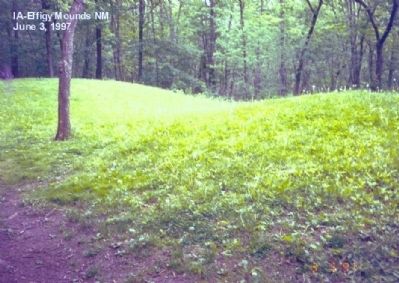
On State Highway 76. Reported permanently removed.
In 1766, English and French Canadian traders wintered near this site. They must have puzzled over these strange earthen shapes-or others even nearer their cabin. The traders could not have known that the humble grave markers were vestiges of a . . . — — Map (db m61987) HM
On Allamakee Street, on the right when traveling north.
This building was completed in 1861 by the firm of Hale, Jenkins and Pratt at a cost of $13,655. The 40-acre townsite, including the place where the building stands, was donated by the Shattuck Family. The Allamakee County Board of Supervisors . . . — — Map (db m69527) HM
On Allamakee Street Northwest (Iowa Route 9) 0.1 miles north of 1st Avenue Northwest, on the right when traveling north.
The Norwegian-American Gjefle log house was built in 1870, and an addition in 1886, in Center Township. It was moved to this site in 1990. — — Map (db m272713) HM
Near Rossville Road (State Highway 9) just north of 13th Avenue Southeast (Park Road), on the left when traveling north.
The Allamakee County Freedom Rock The Allamakee County Freedom Rock project was started in 2016 with an application submitted to the Freedom Rock artist, Ray "Bubba" Sorensen to have Allamakee County placed on his waiting list. . . . — — Map (db m232607) HM WM
On Main Street at 9th Avenue, on the right when traveling east on Main Street.
Founded in 1862, Belle Plaine possesses a rich and dramatic history filled with people and events of local, state, national, and international significance. Highlights from that history are captured in this 19' by 29' sculpted brick mural. . . . — — Map (db m251109) HM
On Main Street East just west of Pearl Street, on the left when traveling west.
John M. Fishel June 30, 1943 Lyle T. Rozell Aug. 29, 1943 Richard L. Lint Nov. 1, 1943 Homer D. Woodson Jan. 26, 1944 Louie E. Popenhagen June 1, 1944 Donald R. Peacock Dec. 24, 1944 Mark R. Reynolds Jr. Mar. 24, 1945 Alfred C. Moody . . . — — Map (db m291688) WM
On Pearl Street just south of Main Street East, on the right when traveling south.
Created around 1900 by Thomas Cusack and Company, Chicago Repainted by Don Wilson of Shellsburg, 1993 Restored by Ed Callan of Shellsburg, 2024, with funding provided by Shellsburg residents, businesses and friends, organized by Shellsburg Area . . . — — Map (db m291697) HM
On Pearl Street (County Road E36) at Jones Street East, on the right when traveling south on Pearl Street.
Built in 1915 by the Iowa Highway Commission. Placed on the National Register of Historic Places in 1998. Retired to pedestrian duty in 2023. To see a video on the history of the bridge and to learn more, scan the code at left or visit . . . — — Map (db m291687) HM
On Main Street East just west of Pearl Street, on the left when traveling west.
Lt. Col. Calvin P. Titus United States Army Calvin Pearl Titus, son of Calvin and Cora Elsadine (Smith) Titus of Vinton, Iowa, moved to Oklahoma with his dad after his mother had died; later living with his Aunt Florence and Uncle . . . — — Map (db m291700) HM
Near A Avenue at West 1st Street, on the right when traveling north.
In the beginning… The plan was to create a resort drawing people to Vinton. In the early days, it was thought that there were 3 Indian Mounds in the area of the town, and because of that, he named the resort, "Park Minne Estema". . . . — — Map (db m239626) HM
Near A Avenue at West 1st Street, on the right when traveling north.
8,500 B.C. Mound Builders The varying cultures collectively called Mound Builders were inhabitants of North America who, during a 5,000-year period, constructed various styles of earthen mounds for religious and ceremonial, burial, . . . — — Map (db m239651) HM
Near A Avenue at West 1st Street, on the right when traveling north.
Points of Interest If you are planning any exploration, please be respectful of private property. 1. BURMEISTER’S ISLAND: Located at Benton/Black Hawk County line, this privately owned island is a haven for numerous wildlife and . . . — — Map (db m239656) HM
On A Avenue just north of West 4th Street, on the right when traveling north.
When ground was broken in November of 1879 for the S.H. Watson Canning Company, it was the beginning of Vinton's identity as the "Corn Canning Capital of the World". Eventually, the Vinton canning industry grew to be the largest in the Midwest. It . . . — — Map (db m176268) HM
Near A Avenue at West 1st Street, on the right when traveling north.
Prior to bridges, anyone living north of Vinton had to cross the Red Cedar by boat to “come to town.” A ferry was established June, 1852 to help with cargo. The county judge established the rates for passage: Foot passenger 5¢; man, horse & vehicle . . . — — Map (db m239636) HM
On A Avenue just south of West 3rd Street (State Highway 150), on the right when traveling south.
Samuel H. Watson, pioneer Vinton banker built the opera house in 1870 at a cost of 20,000 to $25,000. It seated 800 persons and featured live performances in drama, music, and comedy. It was the center of entertainment for the Vinton community. . . . — — Map (db m239697) HM
On 73rd Street 0.3 miles east of U.S. 218, on the right when traveling east.
The Lincoln Highway
The Lincoln Highway became the first transcontinental highway in the nation. It opened the way for motorists to explore the country from the coastline of New York City all the way to the shoreline of San Francisco. . . . — — Map (db m251136) HM
On Lime Street at Branard Street, on the right when traveling east on Lime Street.
Historic Transportation Corridor
From 1912 to 1973, the Waterloo, Cedar Falls, & Northern Railway operated the Cedar Valley Road (CVR) as an electronic rail line providing passenger and freight service between Cedar Rapids, Cedar Falls, and . . . — — Map (db m278882) HM
On Main Street at West Street, on the right when traveling west on Main Street.
The Fryin' Pan was built in 2004 by several local men to promote Brandon's Cowboy Breakfast. It took 41 hours of volunteer labor hours to construct, and was modeled (to scale) after a 10 inch cast iron frying pan. Iowa's Largest Fryin' Pan has an . . . — — Map (db m278383) HM
On Swan Lake Boulevard 0.4 miles west of Iowa Avenue (State Highway 248).
Welcome to the Buchanan County Freedom Rock at Heartland Acres. Thank you for visiting. While visiting this memorial, please enjoy the art and take a lot of pictures. As you enjoy this memorial, please also be conscious of what it represents in . . . — — Map (db m292600) HM
On 2nd Avenue Northwest just north of 1st Street West (County Highway D22), on the right when traveling north.
History of the Wapsipinicon Mill March 7, 1867 the Independence Mills Co. was organized for the purpose of buying water power and building a custom and merchants flouring mill. Work began immediately and began operation as a flouring mill . . . — — Map (db m162161) HM
On Main Street at Washington Avenue, on the right when traveling east on Main Street.
This site is along the original route of the Herbert Hoover Highway, a 42-mile series of local, state and county roads that run between the foot of old capitol in Iowa City and the Cedar County community of Lowden. The Hoover Highway was . . . — — Map (db m251088) HM
On Poplar Street near Wetherell Street, on the right when traveling north.
The four houses on this Poplar Street block were here in the 1870s and 1880s when Herbert Hoover was a boy. Families built the houses on lots they bought from John Wetherell, a Quaker real-estate developer who had subdivided 5 acres. The Hoover's . . . — — Map (db m162572) HM
On Wetherell Street at South Downey Street, on the left when traveling west on Wetherell Street.
Born in a modest two-room cottage, Herbert Hoover spent most of his first 11 years in West branch. He went on to become the President of the United States-the first one born west of the Mississippi River. Here Hoover's parents and neighbors . . . — — Map (db m163143) HM
Near S Downey Street, on the right when traveling south.
“It was here that I was given that tender care of mind and body, those first steps in education, that knowledge of poverty and struggle for family betterment which contribute to understanding of American life.” President . . . — — Map (db m87749) HM
Near S Downey Street, on the left when traveling north.
“My country owes me nothing. It gave me, as it gives every boy and girl, a chance . . . In no other land could a boy from a country village, without inheritance or influential friends, look forward with unbounded hope.” . . . — — Map (db m87751) HM
On Wetherell Street at Downey Street, on the right when traveling east on Wetherell Street.
“My country owes me nothing. It gave me, as it gives every boy and girl, a chance...in no other land could a boy from a country village, without inheritance or influential friends, look forward with unbounded . . . — — Map (db m162568) HM
On South Downey Street at Penn Street, on the left when traveling north on South Downey Street.
This cottage where I was born is physical proof of the unbounded opportunity of American life. In no other land could a boy from a country village, without inheritance or influential friends, look forward with unbounded hope. . . . — — Map (db m162634) HM
On South Downey Street south of West Main Street, on the right when traveling south.
Charles E. Smith, a Civil War veteran and carpenter, moved in the 1880s to West Branch with his wife, Deborah. In 1903 he finished this dream house on top of Cook’s Hill, down the road to your left, where each spring he tapped his maple trees to . . . — — Map (db m162619) HM
On Penn Street at Downey Street, on the left when traveling west on Penn Street.
Visit the West Branch Commercial Historic District, just a block up the street. Buildings from the late 1800s and early 1900s, now listed in the National Register of Historic places, show how downtown West Branch changed from modest wood structures . . . — — Map (db m162607) HM
As a boy Herbert Hoover liked to watch his father, Jesse, shoe horses and repair plows, but he was not always careful. "Playing barefoot around the blacksmith shop," he recalled, "I stepped on a chip of hot iron and carry the brand of Iowa on my . . . — — Map (db m162555) HM
The Hoover family worshipped in this building along with neighbors and relatives who were members of the Religious Society of Friends, or Quakers as they are often called. West Branch was predominately a Quaker community in the 1850's when this . . . — — Map (db m48312) HM
On South Downey Street near Penn Street, on the left when traveling south.
Herbert Clark Hoover was born on August 10, 1874, in this two-room cottage. He spent his early boyhood years on the edge of the village Surrounded by farmland. His parents, relatives, and many neighbors were Quakers whose daily lives were . . . — — Map (db m163144) HM
On Downey Street, on the right when traveling south.
Amanda Garvin was single and 35 when she bought this lot for $90 in 1870 and had the cottage built. She was renting the house by 1878 but lost it to foreclosure in 1885. With its gingerbread trim and ornamental arches, the cottage is a wonderful . . . — — Map (db m162642) HM
The Statue of Isis, Egyptian goddess of life, symbolizes Herbert Hoover's humanitarian efforts. Belgians gave Hoover the bronze statue to thank him for his help and staving off famine in their country in World War I. Hoover, a wealthy mining . . . — — Map (db m162581) HM
This site commemorates the life and accomplishments of Herbert Hover, 31st President (1929-1932). The first president born west of the Mississippi River. Hoover grew up in a tradition that deeply influenced his ideals and long life of public . . . — — Map (db m48307) HM
On Wetherell Street at Poplar Street, on the left when traveling west on Wetherell Street.
Herbert Hoover, the first president born west of the Mississippi, spent his formative years in this neighborhood, which is preserved as Herbert Hoover National Historic Site. You may visit his birthplace and other buildings he remembered from his . . . — — Map (db m162574) HM
On North Downey Street. Reported permanently removed.
"This cottage where I was born is physical proof of the unbounded opportunity of American life."
In 1871, Jesse Hoover built this two-room cottage near his blacksmith shop and moved in with his wife, Hulda, and young son, Theodore. . . . — — Map (db m162633) HM
On Parkside Drive, on the right when traveling east.
President Herbert Hoover died in New York City on October 20, 1964, at the age of 90. Five days later his body was interred on this hillside overlooking his birthplace and presidential library-a symbolic vista of his journey from birth to death. . . . — — Map (db m162637) HM
The Hoovers bought a home on this site in 1879. During the winter Theodore, Herbert and Mary enjoyed sledding with the Peter Smith youngsters who lived in the green house just south of here. Jesse Hoover died in 1880. Hulda passed away three years . . . — — Map (db m48316) HM
Near Parkside Drive. Reported permanently removed.
You are viewing 76 acres of partially restored tall grass prairie, planted in 1971. Extending from the historic Miles Farm, at the hilltop on your left, it provides a south western boundary for the historic site. Prior to the . . . — — Map (db m163147) HM
On South Downey Street at Wetherell Street, on the left when traveling south on South Downey Street.
This was the home of Herbert Hoover's aunt and uncle, Agnes and Laban Miles, before they moved in 1878 to Oklahoma Territory. Laban served as agent on the Osage and Kaw Indian Reservation. Hoover, age eight, stayed with them for several months after . . . — — Map (db m162579) HM
On Penn Street at Poplar Street, on the right when traveling west on Penn Street.
Quakers, including the Hoovers, believe strongly in educating both boys and girls equally, and by 1853 West Branch's population was large enough to build this one-room schoolhouse. Because the Quakers had raised much of the funds, they also used it . . . — — Map (db m162554) HM
Near South Downey Street, on the left when traveling south.
Dr. Lewis J. Leech built and moved into this house in 1920. Before that he hosted ice cream socials and Fourth of July parties on the lot. When Dr. Leech died in 1937 at age 91, former President Hoover praised his “long life of usefulness...to . . . — — Map (db m162610) HM
On South Downey Street, on the left when traveling south.
In this meetinghouse, the Religious Society of Friends, or Quakers, practiced principles of simplicity, honesty, equality, peace, and service to others. These values shaped young Hoover's character and were evident in his humanitarian endeavors . . . — — Map (db m162636) HM
The early settlers of West Branch had a strong regard for education, and in 1853 they built this school. It was used not only as a school but as a place of worship for the members of the Society of Friends. Originally the building housed all of the . . . — — Map (db m162553) HM
Near Parkside Drive, on the right when traveling south.
As a boy Herbert Hoover visited his relatives at their farm on the top of this hill. Issac and Esther Miles' 100-acre property was typical of the self-sufficient farms that surrounded West Branch. In 1880 they had 73 acres under cultivation with . . . — — Map (db m163148) HM
Near Parkside Drive, on the right when traveling south.
This landscape offers a glimpse of the tallgrass prairie that once covered 85 percent of Iowa. By the time of Herbert Hoover's birth in 1874, farmers were converting much of the state's prairie to cropland. When Hoover was a boy, Isaac Miles . . . — — Map (db m163149) HM
On Downey Street at Wetherell Street, on the left when traveling east on Downey Street. Reported permanently removed.
Miss Amanda Garvin purchased this lot in 1870 and by 1872 had this small frame cottage built. She resided here until 1878. Herbert Hoover was familiar with this house and would have passed it often to and from school. The Garvin Cottage is . . . — — Map (db m162640) HM
On Downey Street south of Wetherell Street, on the left when traveling north. Reported permanently removed.
Charles Smith moved to West Branch in the 1880’s and pursued his trade as a carpenter and contractor. In 1903 Smith built this retirement dream home for himself and his wife. They celebrated many special occasions here including their 50th wedding . . . — — Map (db m162618) HM
On Downey Street south of Wetherell Street, on the right when traveling north. Reported permanently removed.
Dr. L.J. Leech opened a medical practice in West Branch in 1882 and practiced here for the next 55 years. For many years he lived in the house one door to the north. In 1920 he moved to this home and lived here until his death in 1937. At his . . . — — Map (db m162609) HM
On Downey Street, on the right when traveling north. Reported permanently removed.
This house was built in 1899 for Hannah Varney. Mrs. Varney lived in the house only about one year, but her daughters Cora and Clara continued to live here until 1915. Although built some thirteen years after Herbert Hoover left West Branch, this . . . — — Map (db m162575) HM
Near East Main Street 0.1 miles east of South Downey Street, on the right when traveling east.
This site is along the original route of the Herbert Hoover Highway, a 42-mile series of local, state and county roads that run between the foot of Old Capitol in Iowa City and the Cedar County community of Lowden. The Hoover Highway was designated . . . — — Map (db m76108) HM
On Downey Street at Wetherell Street, on the right when traveling north on Downey Street. Reported permanently removed.
Herbert Hoover’s distinguished uncle, Laban Miles, owned this house from 1875-1886, and Herbert would have visited the Miles family here on many occasions. In 1878 Laban Miles moved his family to the Oklahoma Territory where he had been appointed . . . — — Map (db m162578) HM
On Poplar Street, on the right when traveling north.
David Mackey, a local carpenter, built this house between 1868 and 1871. He lived in this home until 1876. Mackey also ran a butcher shop and served as mayor of West Branch in 1879 and postmaster in 1885. Built several years before his birth, this . . . — — Map (db m87736) HM
Hannah Varney built this house in 1899 after divorcing her husband. She lived here with her six children less than a year, moved to Iowa City, and left the house to her daughters Cora and Clara, who lived here until 1915.
Photo . . . — — Map (db m162577) HM
On Wetherell Street at Poplar Street, on the left when traveling west on Wetherell Street. Reported permanently removed.
Many of the commercial buildings in West Branch are included in a historic district on the National Register of Historic Places. It commemorates the “Golden Age of American Agriculture” (1895-1916). A variety of shops and services are . . . — — Map (db m162573) HM
Near Interstate 80 at milepost 270, 1 miles west of Rose Avenue (County Highway X64), on the right when traveling west.
Historic Iowa City
The land on which Iowa City is located was a wilderness when it was selected and surveyed for the capital of the Territory of Iowa in 1839. The cornerstone of the new capitol building was laid by Governor Lucas on July 4, . . . — — Map (db m224357) HM
Near Interstate 80 at milepost 270, 1 miles west of Rose Avenue (County Highway X64), on the right when traveling west.
The Herbert Hoover National Historic Site, located in nearby West Branch, honors a distinguished son of Iowa, citizen of the world, and the 31st president of the United States. Established in 1965, the Site’s foundations were laid earlier when in . . . — — Map (db m224358) HM
On River Bluffs Scenic Highway/Hiawatha Pioneer Trail (U.S. 52) at Ivory Rd (County Highway B60), on the right when traveling north on River Bluffs Scenic Highway/Hiawatha Pioneer Trail.
Dedicated June 13, 1954
In memory of deceased members of Post 27
Memorials for
Cyrill Matt and Arthur Meyer
have made this park possible — — Map (db m202889) WM
On Great River Road Hiawatha Pioneer Trail (U.S. 52), on the right when traveling north.
The valley of the Mississippi River is one of the most distinctive landscape features of the central United States. Set in a geologic framework of ancient sea floors and glacial flood waters, this rock-lined corridor hosts interesting . . . — — Map (db m202873) HM
Near Great River Road (State Highway 76) 2 miles north of U.S. 18, on the right when traveling north.
This rock marks the beginning of the Old Military Trail first used in the summer of 1840 by troops from Fort Crawford in Wisconsin when building Fort Atkinson in Iowa. It served as a highway for the movement of troops and supplies from Fort Crawford . . . — — Map (db m44190) HM
Near River Street (Business U.S. 18) 0.4 miles north of Front Street, on the left when traveling north.
Cave History
Workers for the Hagensieck brewery created these cave openings around 1867 using picks, shovels and blasting powder. They used the caves to store ice and beer until the brewery closed in 1888. Hundreds of bats used the caves . . . — — Map (db m46742) HM
John Froelich invented the very first successful gasoline powered tractor able to proplel itself backward and forward, in 1892, right here in this village named after the Froelich family. The blacksmith, William Mann, assisted with the creation of . . . — — Map (db m203106) HM
On Froelich Road, on the left when traveling east.
In this village, John Froelich built the first gasoline tractor that propelled itself backward as well as forward. Far-reaching in its effect on modern agricultural history. It moved out of this village and into the world in 1892.
Later that . . . — — Map (db m202935) HM
On A Street / Dr. Clifford Smith Street west of Main Street ( Highway 76), on the right when traveling west.
McGregor
"Royal is my race," was the motto of Clan MacGregor of which McGregor's founder, Alexander MacGregor, was a descendant. It was 1837 when Alexander began a ferry boat operation on "MacGregor's Landing" that became a thriving town of . . . — — Map (db m44758) HM
On Pikes Peak Road 0.5 miles east of County Highway X56.
Across this impressive gorge of the Mississippi River is the mouth of the Wisconsin River. The steeply notched valleys of both rivers are carved into sedimentary bedrock which underlies the level, plateau-like uplands and forms the abrupt, . . . — — Map (db m46138) HM
Near Pikes Peak Road 0.5 miles east of Highway X56.
Across the Mississippi is the mouth of the Wisconsin River. This is the point where on June 17, 1673 Pere Marquette and Louis Joliet, in two small canoes entered the mighty Mississippi. They were the first white men to discover the Upper Mississippi . . . — — Map (db m44797) HM
On Froelich Road, on the right when traveling south.
The original Froelich Train Depot had been a large building located just to the north of the present location of our current depot. It was located on the west side of the old highway 18 & 52. In 1872, the railroad came through what became known . . . — — Map (db m203108) HM
On Froelich Road, on the left when traveling east.
This store was built in 1891 by Edwin Froelich, after the previous general store burned down that had been located where the Frolelich Monument is currently located. It was called the Iron Clad Store for the exterior was covered with fire-proof . . . — — Map (db m203105) HM
On 6th Avenue (Old U.S. 61) north of 6th Street, on the right when traveling north.
Regional artist John Bloom, a Dewitt
native, spent much of his career
drawing, painting and printing scenes
from the DeWitt area. Bloom studied
at Grant Wood's Stone City and at
the Chicago Art Institute. His work
was influenced by Wood, . . . — — Map (db m251084) HM
On Park Street 0.1 miles east of 3rd Street, on the left when traveling south.
Medal of Honor
WWII Iwo Jima Campaign
15-16 March 1945
Pharmacist's Mate 1st Class
2d Battalion, 24th Marines, 4th Marine Division
U.S. Navy — — Map (db m22944) WM
Built in 1882 by J.K. Graves for his own convenience; and rebuilt after a fire in 1884. It was then opened as public transport.
Originally operated by steam, then by electricity in 1893, the elevator was incorporated as the Fenelon Place . . . — — Map (db m43133) HM
On Iowa Street at West 13th Street, on the right when traveling north on Iowa Street.
Abraham Lincoln Dedicated to the Grand Army of the Republic and The Women Who Served by Dubuque Memorial and Historical Assn
Lincoln’s Address Delivered at the dedication of the cemetery at Gettysburg, November 19, 1863.
Fourscore . . . — — Map (db m128961) WM
On South Locust Street (State Highway 946) at Dodge Street (U.S. 20), on the right when traveling north on South Locust Street.
Jolliet and Marquette, journeying on the Father of Waters, passed here June 16, 1673. Here in 1690, Nicholas Perrot built his trading post. Here in 1788, at the site of the city, incorporated in 1833, bearing his name, Julien Dubuque founded his . . . — — Map (db m202829) HM WM
On East Commercial Street 0.3 miles east of East 7th Street, on the left when traveling east.
Built in 1856. Used for making lead shot and bullets. In use commercially for three years. Later used as a watchtower by a lumber company to guard against fire. The interior woodwork and the top were destroyed by fire in 1911. Restored in 1961 by . . . — — Map (db m43129) HM
Dubuque's Mines of Spain
The city of Dubuque was named for Julien Dubuque, a swarthy French Canadian who came to this area around 1785. Dubuque wooed Potosa, the daughter of Peosta, a Fox Indian chief whose village stood at the mouth of . . . — — Map (db m231312) HM
Dubuque's Mines of Spain
The city of Dubuque was named for Julien
Dubuque, a swarthy French-Canadian who came
to this area around 1785. Dubuque wooed
Potosa, the daughter of Peosta, a Fox Indian
chief whose village stood at the mouth . . . — — Map (db m231298) HM
On Main Street north of West 4th Street, on the right when traveling south.
4th and Main Streets has hosted public entertainment since the 1840’s. Designed by America’s premier theater architects, CW and George Rapp, the Majestic is a Renaissance Revival style with French and Italian influences. The original structure, the . . . — — Map (db m126600) HM
On Monument Drive 0.2 miles east of Mines of Spain Road, on the left when traveling east.
Historic Dubuque - the Key City of Iowa - formed a part of what became French Louisiana when Joliet and Marquette paddled by in 1673. Perrot taught the Miami Indians how to mine lead here in 1690. France ceded Louisiana west of the Mississippi . . . — — Map (db m224587) HM
On Main Street south of West 12th Street, on the right when traveling south.
St. Luke’s United Methodist Church is the outcome of the first church organized in what is now the State of Iowa.
Reverend Barton Randle was appointed to the Dubuque circuit and mission and preached his first sermon in the Bell tavern on . . . — — Map (db m128952) HM
On Central Avenue (U.S. 52) at East 8th Street, on the left when traveling south on Central Avenue.
Dubuque’s first jail stood on this site (1836) and was superseded by this building which has been in continuous use since 1857 as sheriff’s residence and jail. Its design is the finest example of Egyptian architecture to survive the classical . . . — — Map (db m126598) HM
Julien Dubuque was born on January 10, 1762 at Trios Rivieres near Quebec, Canada. In 1788, he established a trading post and lead mining smelter at the mouth of Catfish Creek. He was active in fur trading and lead mining with the Mesquakie . . . — — Map (db m133496) HM
Oldest log cabin in Dubuque County.
About 1827.
Occupied by the pioneer settler William Newman.
1834.
Brought to this site and restored
through the efforts of
Frederick E. Bissell, Sr.
Aided by interested citizens
and members of
the . . . — — Map (db m43131) HM
On Locust Street at Sixth Street, on the left when traveling north on Locust Street.
On this site a Methodist Chapel was constructed in 1834.
As the first church in Iowa, it served not only as a place of worship but as a community center in an early spirit of civic concern, ecumenism and racial integration. At various times . . . — — Map (db m22957) HM
On Central Avenue (U.S. 52) north of East 8th Street, on the left when traveling north.
Old Dubuque County Jail was built in 1857 by architect John Francis Rague. The Old Jail is one of only three surviving Egyptian Revival buildings in the entire United States. It is listed on the National Register of Historic Places and is also an . . . — — Map (db m126597) HM
The Shot Tower was constructed in 1856 to manufacture lead shot ammunition. Molten lead was poured from the top of the tower and passed through a series of sieves to form the shot into its proper size. The shot then landed in a tank of cold water . . . — — Map (db m43645) HM
On Main Street at West 1st Street, on the left when traveling south on Main Street.
Terminus of the Old Military Road from Dubuque to the Northern boundary of Missouri Authorized by Congress 1839 Marked by Iowa Daughters of the American Revolution 1937 — — Map (db m150707) HM
On Mines of Spain Road 0.3 miles east of Monument Drive.
The burned and "dug-out" canoe and the bent and stitched together birch-bark canoe are surely close to the "wheel" as one of the most important inventions of man. Paddling south of the great Mississippi River from the Wisconsin River were the . . . — — Map (db m133495) HM
Mines of Spain Recreation Area
There is evidence of prehistoric Native American cultures, some dating back as many as 8,000 years. Mounds, village sites, rock shelters, trading post sites, and campsites dot the landscape of this region. . . . — — Map (db m133497) HM
405 entries matched your criteria. The first 100 are listed above. Next 100 ⊳