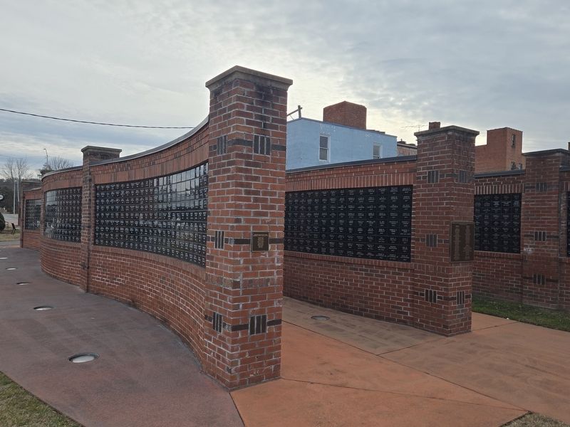
On East E Street at Armed Forces Drive, on the left when traveling west on East E Street.
World War I
Orville Lewis
World War II
George M. Ammons •
Bernie Birchfield •
Irick I. Birchfield •
Carl W. Boyd •
Fred L. Cable •
Henry Calloway •
Frank Verran Carver (MIA) •
John R. Clark •
Thomas Coleman •
John R. . . . — — Map (db m294326) WM
On State Highway 91 at Broad Street, on the right when traveling east on State Highway 91.
About 1 mile S.W., at the home of a daughter, Mary Johnson Stover, Andrew Johnson died in 1875. He had been a senator from Tennessee; governor of Tennessee; military governor under Federal occupation; vice-president of the United States and 17th . . . — — Map (db m157912) HM
On South Sycamore Street at Hattie Avenue, on the right when traveling south on South Sycamore Street.
This 1921 T Model fire engine carried chemicals rather than water for extinguishing fires. Several years ago firemen and friends restored the vehicle to its present "cherry" red condition. — — Map (db m306549) HM
On East Elk Avenue at Academy Street, on the right when traveling west on East Elk Avenue.
The Riverview Building was built in the late 1930's atop the foundation of what was originally the tavern where it is said
former President Andrew Johnson took his last drink, in 1875. Later that night he died from a stroke. — — Map (db m293562) HM
On East Elk Avenue just west of Post Office Street, on the left when traveling east.
Barnes Boring was officially established as a corporation on February 26, 1900 with J. M. Barnes and J. R. Boring as principal stockholders. The two gentlemen died just months from each other nearly 30 years after beginning their partnership. — — Map (db m192800) HM
On West Elk Avenue (U.S. 321) 0.1 miles east of Hudson Drive, on the right when traveling east.
In the 1920s, German and Dutch investors established two factories for the production of rayon in Elizabethton: American Bemberg Corporation and North American Rayon Corporation. The East Tennessee and Western North Carolina Railroad (ET&WNC), . . . — — Map (db m135498) HM
On West Elk Avenue (U.S. 321) west of Bemberg Road, on the right when traveling east.
These concrete footings held the Bemberg Water Tower which supplied water to the ET&WNC (Tweetsie) steam engines in the early 1900’s. Project funded by www.cartercountyhistory.com website and the alumni of the 2014-2015 Carter County Adult . . . — — Map (db m135497) HM
On East Elk Avenue east of South Sycamore Street, on the right when traveling east.
This walkway now exists where once the Grand Theater, the first theater in Elizabethton, stood. The theater had a balcony for blacks only, but legend has it that sometimes white men snuck up the stairs to join them and smoke cigars. — — Map (db m192802) HM
On South Sycamore Street south of East Elk Avenue, on the right when traveling south.
The Bonnie Kate Theater was built in the classic revival style of
architecture. It was named after Miss Katherine Sherrill Sevier
the wife of the first governor of Tennessee, John Sevier. The theater
opened to a house of 500 from the 1920's to . . . — — Map (db m306548) HM
Near West G Street (Tennessee Route 67) at West Elk Avenue (U.S. 321), on the right when traveling west.
Nearby Buffalo Creek is one of numerous place names in the Southern Appalachian mountains that serve as reminders that the buffalo, or American bison, was once plentiful in the region. In 1769 Daniel Boone narrowly escaped being trampled by a . . . — — Map (db m184052) HM
On East Elk Avenue east of South Sycamore Street, on the right when traveling east.
Established in 1892 by Harry Burgie, Burgie Drug, a revered establishment which was visited frequently by Elizabethton residents, served the community as a pharmacy and convenience store. — — Map (db m192801) HM
On East Elk Avenue east of South Main Street, on the right when traveling east.
This clapboard-sided Greek Revival style home was built by Henderson Folsom around 1861 on what were the tracks #48 and #49 of the original 77 lots laid out in 1796. Elizabethton incorporated in 1799. — — Map (db m293373) HM
On North Main Street at East Elk Avenue, on the right when traveling north on North Main Street.
Originally built during the 1850's. It survived severe wind storm damage in March of 1901 and flood damage during the great flood that year wiping out twenty-three Elizabethton dwellings and all bridges except the covered bridge. — — Map (db m293376) HM
On North Main Street at East Elk Avenue, in the median on North Main Street.
In Memory of Mary Patton who made the powder that fought the King’s M’T’N’ Battle placed by her great grand son. T.Y. Patton
Built in honor of all soldiers of Carter County in all the wars from the revolution down to this date, 1912, by . . . — — Map (db m135496) HM WM
Carter County’s railroad history is the story of three trains – the East Tennessee and Western North Carolina, better known as Tweetsie (1881-1951); the Southern Railroad (1911-1940); and the North American Rayon Steam Engine (1936-1992). The . . . — — Map (db m46561) HM
John Carter
- 1781
Chairman of Watauga Association and of the five commissioners who established that first written compact for civil government by American-born freemen. Chairman of Committee of Safety. In Revolution, colonel of militia . . . — — Map (db m157908) HM
On Southside Road, on the right when traveling east.
Cedar Grove Cemetery was originally established as a "colored cemetery" in the early nineteenth century on a tract of land adjacent to a trail that became known as Gap Creek Road. The remote and rocky terrain often required the use of dynamite to . . . — — Map (db m81370) HM
Near East Elk Avenue east of South Sycamore Street, on the right when traveling east.
On this location the citizens of Elizabethton, Tennessee have dedicated a Time Capsule as the finale of their year long celebration of Elizabethton’s 200 Years. The capsule buried here is to be opened in the year 2099 AD. With this . . . — — Map (db m192864) HM
On South Riverside Drive at 3rd Street, on the right when traveling north on South Riverside Drive.
This bridge over Doe River was built early in 1882 at a cost to the county of $3000 for the bridge and $300 for the approaches. The site was chosen by J.J. McCorkle, Wiley Christian and H.M. Rentfro. The committee were Thomas E. Matson, Engineer, . . . — — Map (db m46706) HM
Near West Elk Avenue (U.S. 321) west of Franklin Springs Circle, on the right when traveling west.
"Be always sure you are right, then go
ahead!" David Crockett
In the 49 years that David Crockett called Tennessee his home he migrated from one end of the Volunteer state to the other. From his birthplace near Limestone on the . . . — — Map (db m268085) HM
On East E Street at Armed Forces Drive, on the left when traveling west on East E Street.
World War One
Robert B. Cable •
Nathaniel W. Ellis •
Lynn H. Folsom •
Robert H. Goodwin •
John B. White
World War Two
Stokes M. Taylor
Korean War
Buster Shell — — Map (db m294327) WM
On Academy Street 0.1 miles south of Broad Street (U.S. 19E).
These stones are from the foundation of the academy established Sept. 13, 1806, with Maj. George Duffield, Chairman, Nathaniel Taylor, George Williams, Alexander Doran & John Greer, Trustees. In 1807, Andrew Taylor, Abraham Henry and Reuben Thornton . . . — — Map (db m46607) HM
On Academy Street north of 1st Street, on the left when traveling north.
Duffield Academy, named for attorney George Duffield, was established
September 13, 1806. The original brick building was erected in 1838. The school for many years was operated as an elementary school. — — Map (db m293553) HM
On Hattie Avenue west of South Riverside Drive, on the right when traveling west.
The Dungan House, was constructed by Judge W. P. Dungan in 1892, band is believed to be the first house built in the New Town. It was the first house in Elizabethton to have electric lights, a residential
telephone, and its own private water . . . — — Map (db m306553) HM
On Church Street at South Lynn Avenue, on the right when traveling east on Church Street.
This independent semi-professional barnstorming Negro baseball team consisted of young men from Elizabethton, Johnson City, Kingsport, Greeneville, Middle Tennessee, Kentucky, Bristol, and Martinsville, Virginia. Because of segregation, their . . . — — Map (db m157901) HM
On East Elk Avenue at Armed Forces Drive, on the left when traveling east on East Elk Avenue.
The Elizabethton- Carter County Veterans Walk of Honor was dedicated on November 10, 2007 in grateful recognition of 6,700-plus Carter Couuty veterans now serving or who have served in the military with honor and valor.
Donors for the . . . — — Map (db m294325) WM
On South Riverside Drive north of Hattie Avenue, on the right when traveling north.
In 1772 the first court west of the Alleghanies was held under this tree
Additional marker:
In 1772, four years before the Declaration of Independence, settlers in the Watauga Valley adopted the “Articles of the Watauga . . . — — Map (db m157905) HM
On West Elk Avenue (U.S. 321) west of Franklin Springs Circle, on the right when traveling west.
In May 1776 the Cherokee chiefs, alarmed by the expansion of white settlers onto their land, gave the Wataugans twenty days to leave their lands or face war. The Wataugans asked for more time and built Fort Watauga (also called Fort Caswell) near . . . — — Map (db m268366) HM
On Monument Place at G Street, on the right when traveling west on Monument Place.
To the memory of the patriots who on their way to King's Mountain under Sevier, Shelby and Campbell assembled here September 25, 1780
Fort Watauga, First (Settlers) Fort Built West of the Alleghanies. 1770 . . . — — Map (db m268070) HM WM
On South Riverside Drive at Johnson Avenue, on the right when traveling south on South Riverside Drive.
Both the Franklin House and Hunter Cottage were built by Dr, E. E. Hunter for his children. Neither of the houses originally included a kitchen since the daughters and their families were expected to take meals at the "big house". — — Map (db m293866) HM
On East Elk Avenue near South Main Street, on the right when traveling east.
The 86-foot Fraser Fir located next to the Folsom House is the tallest Fraser Fir in Tennessee and second tallest in the U.S. The tree was one of two planted by Major H. M. Folsom, Civil War veteran. — — Map (db m293374) HM
On West G Street at Mary Patton Highway ( Route 362), on the right when traveling west on West G Street.
This project focused on one mile of the stream that you see above this sign. It was coordinated by the Boone Watershed Partnership, a non-profit organization in
northeast Tennessee that is dedicated to improving the quality of water resources. . . . — — Map (db m268068) HM
On West Elk Avenue (U.S. 321) at West Mill Street on West Elk Avenue.
The Tipton family cemetery, it stood near the homesite of Samuel Tipton (1752-1833) and Susannah Reneau (1767-1853). Col. John Tipton, father of Samuel, deeded it to him in 1784. The house was later the home of a nephew, Isaac P. Tipton, whose . . . — — Map (db m81371) HM
On North Riverside Drive at East Street, on the right when traveling north on North Riverside Drive.
The Race of the Doe River
A mill race is a current of water that turns a water wheel, or the channel conducting water to or from a water wheel. Shown above is the Mill Race of the Doe River. This body of water was diverted from a broader . . . — — Map (db m293703) HM
On South Riverside Drive just north of Johnson Avenue, on the right when traveling south.
Built in 1902, Hunter Cottage displays an English architectural influence in the barley twist spindles that line the lovely oak staircase and in the pocket doors which lead into the dining room. — — Map (db m294332) HM
Near West Elk Avenue (U.S. 321) west of Franklin Springs Circle, on the right when traveling west.
"My father's name was John Crockett, and he was of Irish descent. I have learned that he was a soldier in the revolutionary war, and took part in that bloody struggle. He fought, according to my information, in the battle at Kings Mountain . . . — — Map (db m268101) HM
Near Sparks Road just north of Milligan Highway ( Route 359), on the right when traveling north.
During the early years of European settlement in this valley, Mary McKeechan Patton (1751-1836) operated a gunpowder mill along Powder Branch not far to the south of this spot. Mary McKeechan was born in England and her family immigrated to . . . — — Map (db m183985) HM
On Milligan Highway (State Highway 359) at Blowers Boulevard (State Highway 2530), on the left when traveling south on Milligan Highway.
Buffalo Creek Christian Church organized here in 1830. In 1867 Buffalo Male & Female Institute was established by Rev. W.G. Barker on land given by Joshua Williams. Josephus Hopgood of Ky. purchased it in 1875, naming it Milligan College in 1882, . . . — — Map (db m157861) HM
Near State Highway 67 just north of Monument Place, on the left when traveling north.
The stone obelisk on the hill to the south, erected in 1909 by the Daughters of the American Revolution, is dedicated "To the memory of the patriots who, on their way to King's Mountain under Sevier, Shelby, and Campbell, assembled here September . . . — — Map (db m183937) HM
On West Elk Avenue (U.S. 321) west of Franklin Springs Circle, on the right when traveling west.
After the British captured Charleston in May 1780, the Watauga country became a base from which the Patriots marched against the British and Loyalists in the east. British General Lord Cornwallis knew he must defeat these and other partisans and, on . . . — — Map (db m268379) HM
On East Elk Avenue just west of Post Office Street, on the left when traveling east. Reported missing.
At least one account has it that in 1908 the post office moved into this building which was owned by Postmaster E. C. Alexander. In July 1920, Dr. C. C. Hacker opened medical offices in this building. — — Map (db m293704) HM
On U.S. 19E at Valley Forge Christian Church Road, on the right when traveling south on U.S. 19E.
At Valley Forge, Dan Ellis usually assembled for Federal regiments whom he guided over obscure mountain trails to Kentucky, while East Tennessee was under Confederate control. Born 1827 and a veteran of the Mexican War, he was subsequently Captain . . . — — Map (db m135595) HM
On Horace Leftwich Lane at S Watauga Ave, on the right when traveling east on Horace Leftwich Lane.
In 1867, the Rev. Horace Leftwich, a former slave, founded the Elizabethton Colored Baptist Church. The next year, it was one of the five original churches that established the Watauga Baptist Association. In 1869, after joining the Bethel District . . . — — Map (db m263908) HM
Near East Elk Avenue at North Main Street, in the median.
Post World War II Army Reserve Unit
3299th Ordnance Maint. Co. U.S.A.R.
1st Reserve Unit in Tenn.
In memory of those who served
Capt. J. I. Cornett C.O. •
Capt. Carl Gross E.X.O. •
Fst/Sgt. Dale M. Bendetto •
M/Sgt. Blaine Hartley . . . — — Map (db m293550) WM
On Milligan Highway (State Highway 359) at Powder Branch Road (State Highway 2558), on the right when traveling east on Milligan Highway.
100 yards upstream at a falls stood an old powder mill, where Mary McKeehan Patton made powder for the soldiers who went to King's Mountain, Oct. 7, 1780. Michael Hyder, Sr., signer of the Halifax Petition in 1776 lived here and is buried on the . . . — — Map (db m157864) HM
On North Sycamore Street just north of East E Street, on the left when traveling north.
The older (eastmost) portion of this building, Classical Revival in design, originally served as Elizabethton’s main post office. James A. Wetmore, working for the WPA, designed the building in 1931, and it was constructed in 1933. — — Map (db m183929) HM
Near West G Street (Tennessee Route 67) 0.1 miles west of Sabine Street, on the left when traveling west.
Bringing Sabine Hill Back to Life Sabine Hill remained in the Taylor family through the latter 1940s. In August 1936, W. Jeter Eason with the Historic American Buildings Survey (HABS) visited Sabine Hill and took detailed photographs . . . — — Map (db m174641) HM
On North Riverside Drive at East Street, on the right when traveling north on North Riverside Drive.
At the turn of the 20th century, the Mill Race was a healthy stream with naturally vegetated banks. Over the years, as industries supported by the Mill Race came and went, the stream deteriorated to a condition of stagnant flow and siltation. In . . . — — Map (db m293702) HM
On West Elk Avenue (U.S. 321) west of Franklin Springs Circle, on the right when traveling west.
This marker commemorates the
men and women who achieved
American independence
These Patriots, believing in the
noble cause of liberty, fought
valiantly to found a new nation
1775-1783 — — Map (db m268373) WM
Near West Elk Avenue (U.S. 321), on the left when traveling north.
This marker commemorates the men and women who achieved American independence. These Patriots, believing in the noble cause of liberty, fought valiantly to found a new nation.
1775-1783
Presented by Tennessee State Society Daughter of the . . . — — Map (db m309938) WM
On Hattie Avenue west of South Riverside Drive, on the right when traveling west.
This handsome house was built by Capt. L. H. Rhudy and Carrie Dungan Rhudy in 1894 and remained in the family until 1992. Two other original buildings remain on the property: a four-person, two-door brick outhouse and the carriage house. — — Map (db m306551) HM
On East Elk Avenue west of North Sycamore Street, on the left when traveling east.
Originally one of four movie theaters in downtown Elizabethton, this building was constructed in the late 1920's by local building contractor, Thomas Construction Company. The Art Nouveau style building is the only one of its type in Elizabethton. — — Map (db m293855) HM
On East Elk Avenue east of Elm Street, on the left when traveling east.
S. H. Kress & Co. was the trading name of a chain of "five and dime" retail department stores in the United States, established by Samuel Henry Kress, which operated from 1896 to 1981. The Kress chain was known for the architecture of its buildings. — — Map (db m293862) HM
Near West G Street (Tennessee Route 67) at U.S. 321, on the left when traveling west.
Sabine Hill, the large Federal-style structure on the knoll to the south, is one of the oldest surviving homes in Carter County. General Nathaniel Taylor (1771-1816), a veteran, of the War of 1812, began the construction of Sabine Hill shortly after . . . — — Map (db m174643) HM
On New Elizabethton Highway (Tennessee Route 67) 0.3 miles north of Buck Van Huss Drive, on the right when traveling north.
Built about 1818 by Mary (“Polly”) Patton Taylor, widow of Gen. Nathaniel Taylor, of the War of 1812. Both are buried in the cemetery nearby. Among their great-grandsons were Governors Alfred A. and Robert L. Taylor, of Tennessee, and Nathaniel . . . — — Map (db m46387) HM
On North Main Street at East Elk Avenue, on the right when traveling north on North Main Street. Reported permanently removed.
Although Tennessee voted to secede from the Union in June 1861, East Tennessee remained staunchly loyal. The residents of Carter County voted against secession, 1,343 to 86.
One of those residents, Admiral and General Samuel P. Carter (born . . . — — Map (db m293369) HM
On North Main Street at East Elk Avenue, on the right when traveling north on North Main Street.
Although Tennessee voted to secede from the Union in June 1861, East Tennessee remained staunchly loyal. The residents of Carter County voted against secession, 1,343 to 86.
One of those residents, Admiral and General Samuel P. Carter (born . . . — — Map (db m293370) HM
On East Elk Avenue 0.1 miles west of Veterans Memorial Parkway (U.S. 19E), on the right when traveling west.
Born in this house. After attending Washington College and Princeton, graduated from U.S. Naval Academy; serving in the Navy until May 1, 1862, he was appointed brigadier general, U.S. Volunteers. His most conspicuous service was a raid into East . . . — — Map (db m46749) HM
On East Elk Avenue east of South Sycamore Street, on the right when traveling east.
This plaque is dedicated to Samuel Tipton, founder of Elizabethton. Born in 1752, Samuel Tipton was the eldest son of Col. John and Mary Butler Tipton. A Revolutionary War soldier, he owned the land on which Elizabethton is now located. His Green . . . — — Map (db m157907) HM
On Academy Street at 1st Street, on the right when traveling south on Academy Street.
Built sometime before 1894, this house was constructed by the builder/owners of an overall factory. The basement still includes the river rock from which it was originally built. — — Map (db m293560) HM
On East Elk Avenue at North Main Street, in the median on East Elk Avenue.
The Soldiers' Monument was constructed in 1912 and dedicated in 1913 to all soldiers from the Revolution to that time. The monument was refurbished in 1989 and dedicated to Carter County soldiers serving in all wars. — — Map (db m293377) HM WM
On East Elk Avenue at South Main Street, in the median on East Elk Avenue.
Let it be remembered that on this day Oct. 12, 2013 loyal citizens of Carter County
once again came together as one to honor our soldiers of all wars and to celebrate
the centennial of the soldiers monument. — — Map (db m293378) WM
On East 2nd Street at North East Street, on the left when traveling east on East 2nd Street.
St. Thomas Episcopal Church was formerly the Southern Methodist Church. The United Methodists were among the first organized
religious believers in the city, dating back to 1833. The building was started in 1861 and completed in 1867. — — Map (db m293549) HM
On West Elk Avenue (U.S. 321) 0.1 miles south of Williams Avenue, on the right when traveling north.
Sycamore Shoals, located just to the north of this spot, was a significant place in early American history. The site is named for a stretch of shallow rapids along the Watauga River and for the abundant sycamore trees along its banks. The shoals . . . — — Map (db m157870) HM
On West Elk Avenue (U.S. 321) west of Franklin Club Drive, on the right when traveling west.
In this neighborhood, on Sept. 26, 1780, Rev. Samuel Doak conducted religious services for the frontiersmen from Virginia and North Carolina, including the Watauga and other settlements in what is now Tennessee, upon the start of their decisive . . . — — Map (db m268077) HM
On West Elk Avenue (U.S. 321) west of Franklin Springs Circle, on the right when traveling west.
Sycamore Shoals, a rapids on the Watauga River, and the Sycamore Flats were the hub of the Watauga settlements. These settlements were among the earliest permanent Anglo-American colonies beyond the Indian boundary line and the birthplace of . . . — — Map (db m268377) HM
Near West Elk Avenue west of Franklin Springs Circle, on the right when traveling west.
Sycamore Shoals and its adjoining Flats is one of the most significant areas in the history of Tennessee. It was the center of the Watauga Settlement, the first permanent settlement west of the thirteen original colonies. During the struggle for . . . — — Map (db m268284) HM
On South Riverside Drive north of Hattie Avenue, on the right when traveling north.
The first republic established west of the Appalachians was the Watauga Association, which was formed in May 1772 under the shade of an old Sycamore tree, located on the banks of the Doe River. The famed tree, was cut down in 1987, after efforts to . . . — — Map (db m306554) HM
On South Riverside Drive at Hattie Avenue, on the right when traveling north on South Riverside Drive.
Built in 1882, the Covered Bridge is believed to be the oldest such
bridge in the state that is still in use. It is one of two bridges in
Tennessee identified by a Tennessee historical marker and is
included on the National Registry of Historic . . . — — Map (db m306556) HM
On Laurels Road (Tennessee Route 361) 0.1 miles west of Scioto Road, on the left when traveling north.
Once known as Dry Creek Camp Ground, this park was developed during the mid-1930s under the New Deal's Emergency Relief Act. Many of the features you see, including the shelters and wading area, were completed in 1937.
Until the early 1940s, . . . — — Map (db m293720) HM
Near Broad Street 0.1 miles east of Circle Drive, on the left when traveling east.
“The Mansion” was built before 1780 by John Carter and his son Landon. John Carter was chairman of the Watauga Association, a court of five men elected by the settlers of the Watauga Count in May 1772, “to govern and direct for the . . . — — Map (db m47102) HM
Near West G Street (Tennessee Route 67) 0.1 miles west of Sabine Street, on the left when traveling west.
"Happy Valley" and Sabine Hill (1778-1853) In 1778, during the Revolutionary War, Andrew Taylor traveled from Virginia to what would later become eastern Tennessee. Taylor settled near this location on the Powder Branch of Buffalo . . . — — Map (db m174640) HM
On West Elk Avenue (U.S. 321) west of Franklin Club Drive, on the right when traveling west.
The Tipton family was among the earliest and largest landowners in the Watauga Settlement. The first Tiptons arrived by 1775. Four years later they owned nearly 3,000 acres in Carter County with major landowners being Major Jonathan Tipton, . . . — — Map (db m268072) HM
On West Elk Avenue (U.S. 321) west of Franklin Club Drive, on the right when traveling west.
In this valley, March 17, 1775, the Transylvania Company, led by Richard Henderson, John Williams and Nathaniel Hart, bought from the Cherokee, led by Chief Oconostota, all the lands between the Kentucky and Cumberland Rivers. Over 20 million acres . . . — — Map (db m268080) HM
Near West G Street (Tennessee Route 67) 0.1 miles west of Sabine Street, on the left when traveling west.
Understanding Early Inhabitants East Tennessee has been the site of continuous human occupation for thousands of years. Archaeology is an important tool for understanding the early inhabitants of Sabine Hill. Through the study of . . . — — Map (db m174639) HM
On Franklin Club Drive 0.2 miles West Elk Avenue (U.S. 321), on the left when traveling west.
After the July 21, 1776 attack, the second fort was built on land owned by Sevier, and joining the historic shoals on the Watauga River he and his family played a major role in the Watauga Association and the early settlement of Tennessee. . . . — — Map (db m157866) HM
On East Elk Avenue at Armed Forces Drive, on the right when traveling west on East Elk Avenue.
The Veterans Walkway is a commemorative monument dedicated to the men and women from Carter County who served in the armed forces. Military personnel names are
engraved in each panel making up the walkway. — — Map (db m293730) WM
On West Elk Avenue (U.S. 321) west of Franklin Club Drive, on the right when traveling west.
400 yards northward and ½ mile northeast of the mouth of Gap Creek, stood Watauga Fort. Here, July 21, 1776, the settlers under Captain James Robertson repulsed the Cherokees under Old Abraham of Chilhowee, and Lt. John Sevier rescued “Bonny Kate” . . . — — Map (db m268078) HM
On East Elk Avenue at North Main Street, on the right when traveling west on East Elk Avenue.
Where the Watauga Association was formed in 1772, being the first place west of the Alleghenies where men joined together in a written compact for civil government and for the preservation of their ideals of liberty.
The Thirteen . . . — — Map (db m135499) HM
On West Elk Avenue (U.S. 321) west of Franklin Club Drive, on the right when traveling west.
Here, March 19, 1775, at the Sycamore Shoals, the Watauga Association, Charles Robertson, Trustee, bought from the Cherokee, with Oconostota as chief, lands along the Watauga, Holston and Great Canaway (now New) Rivers. The consideration for the . . . — — Map (db m268079) HM
On North Main Street at East 2nd Street, on the left when traveling north on North Main Street.
Formerly a Presbyterian Church, this Greek Revival Style building is probably the oldest church in the city, dating back to 1836. The Civil War almost forced the church to close as many of the leading
families were slave owners, and moved away. — — Map (db m293552) HM
On East Elk Avenue at North Main Street, on the right when traveling west on East Elk Avenue.
Since World War I, more than 92,000 American soldiers are unaccounted for.
This unoccupied seat is dedicated to the memory of those brave men and women and to the sacrifices each made in serving their country.
God Bless You. God Bless . . . — — Map (db m293372) WM
On U.S. 19E at Mill Pond Road, on the right when traveling south on U.S. 19E. Reported missing.
1/2 mile E. of Valley Forge on Doe River are the ruins of an iron furnace built in 1820 by William B. Carter of Elizabethton. It was purchased in 1824 by James, John, and Joseph O'Brien and William Gott. They owned 9000 acres of land and operated . . . — — Map (db m219553) HM
Near U.S. 19E 0.1 miles south of Spring Street, on the right when traveling south. Reported missing.
The East Tennessee & Western North Carolina Railroad was chartered in 1866 as a 5 ft “broad gauge” line from Johnson’s Depot (now Johnson City) to the Cranberry Iron Works in North Carolina. Construction began in 1868 but was halted in 1870 at . . . — — Map (db m286978) HM
On Elizabethton Highway (Tennessee Route 91) at Fleming Road, on the right when traveling west on Elizabethton Highway.
[Front] Established 1796 named in honor of
Landon Carter
Treasurer of Washington and Hamilton Districts. Speaker of the first State of Franklin Senate, later its Secretary of State, also Lieutenant Colonel of the Washington . . . — — Map (db m45948) HM
Near Happy Valley Road just north of Milligan Highway ( Route 359), on the left when traveling north.
Railroads were a major force in developing southern Appalachia, bringing jobs, commerce, industry, and transportation to local communities. However, the mountainous terrain presented unique challenges to their construction. The East Tennessee and . . . — — Map (db m184200) HM
Near Happy Valley Road just north of Milligan Highway ( Route 359), on the left when traveling north.
In 1902, the Cranberry Furnace Company opened this quarry to provide lime for the Johnson City iron foundry. The quarry featured a crusher and a 924' railroad siding to load the crushed lime on to the ET&WNC train for transportation to Johnson . . . — — Map (db m184199) HM
On Elizabethton Highway (Tennessee Route 91) at Smalling Road, on the right when traveling east on Elizabethton Highway.
6.5 miles northwest, at the mouth of Brush Creek, is a mill built by Jeremiah Dungan in 1779, and continuously operated since then. East of it was a stone fort erected by pioneers of the Watauga Settlement.
Dungan and other pioneers are buried . . . — — Map (db m45997) HM
Near Greenlee Road at Cedar Grove Road, on the right when traveling north.
"Gandy dancer" is a term that came to be used for the laborers who built and maintained railroad tracks prior to the mechanization of most of those tasks. The origin of the term is uncertain, although some suggest that it referred to the movement . . . — — Map (db m184189) HM
Near Happy Valley Road just north of Milligan Highway ( Route 359), on the left when traveling north.
High grade magnetite iron ore was found at the base of Roan Mountain near Cranberry, NC after the War of 1812. A "bloomery", or iron smelter, was built at Cranberry in 1820 to process the ore and supply iron to the Confederacy during the Civil War. . . . — — Map (db m184266) HM
On Tool Branch Road (Tennessee Route 2530) at Odom Acres Drive, on the right when traveling north on Tool Branch Road.
One of that heroic band who established a civilization in the wilderness. She made the powder used by John Sevier's troops in the battle of King's Mountain. — — Map (db m293726) HM
Near Cedar Grove Road 0.1 miles west of Milligan Highway ( Route 359), on the right when traveling north.
Not far from this spot stood the Milligan College Flag Stop, which from 1896 until 1934 provided shade and shelter for passengers who waited for the East Tennessee and Western North Carolina Railroad — the "Tweetsie" — to take them either west to . . . — — Map (db m184193) HM
Near Emmanuel Drive north of Cedar Grove Road, on the left when traveling north.
Washington County, then part of North Carolina, was established in 1777 during the height of the American Revolution, replacing the earlier Washington District (1776) and Watauga Association (1772). On February 23, 1778, the first court of the new . . . — — Map (db m184139) HM
Near Greenlee Road at Cedar Grove Road, on the right when traveling north.
The East Tennessee and Western NC Railroad (ET&WNC) became affectionately known as the "Tweetsie" because of the distinctive sound of its steam whistle. In addition, the railroad was famous for its small-town charm, earning the nickname of "the . . . — — Map (db m184162) HM
On Governor Alf Taylor Road east of Country Garden Road, on the left when traveling east.
The Edmund Williams family, pioneers of
the area. owned the original log cabin at
this site. Owner Joshua Williams (1808-1895)
enlarged the house and in 1866 gave land
for Buffalo Institute. Now Milligan College,
it was established by Col. W. . . . — — Map (db m157849) HM
Near Roan Road (Tennessee Route 143) 1 mile north of Cove Creek Road, on the left when traveling north.
Carter County, especially the area around Roan Mountain, suffered from the effects of occupation during the war. Residents were divided in their support of the Union and the Confederacy, and raids were commonplace.
Union General Samuel P. . . . — — Map (db m286979) HM
On Hwy 143 0.1 miles north of Smith Branch Road, on the left when traveling north.
First Night's Encampment of King's Mountain Men. Sept. 26, 1780 They trusted in God and kept their powder dry Placed by John Sevier Chapter DAR 1910 Reset 1965 — — Map (db m221241) HM