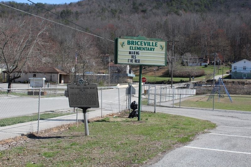
On Slatestone Road, on the left when traveling north.
Coal Creek valley was the scene of an armed rebellion against the state by free miners seeking an end to the common practice of leasing convicts to coal companies. On Oct. 31, 1891 the convict laborers at Briceville were freed by armed miners. The . . . — — Map (db m102292) HM
On Briceville Highway (Tennessee Route 116), on the right when traveling south.
Built in 1888 by Welsh coal miners, the church and its cemetery are listed on the National Register of Historic Places. Miners who fought the Tennessee National Guard over the use of convict labor during the Coal Creek War and the church was a . . . — — Map (db m102331) HM
On Briceville Highway (Tennessee Route 116), on the right when traveling south.
The Cross Mountain Mine opened in 1888 approximately one mile up Slatestone Road to the west. By 1911, it had two power plants to generate electricity, providing incandescent light for the main entries. Coal was cut by electric chain machines and . . . — — Map (db m102329) HM
On Slatestone Road, on the left when traveling north.
Powell Harmon wrote a farewell letter before suffocating in the Fraterville Mine in 1902 that said, "My boys, never work in the coal mines.: His eldest son, Briceville student Condy Harmon, knew that honoring such a request would subject his family . . . — — Map (db m102425) HM
On Briceville Highway (Tennessee Route 116) at ircle Cemetery Road, on the left when traveling south on Briceville Highway.
Thirty-one of the 84 miners who perished in the December 9, 1911 explosion of the Cross Mountain Mine are buried in concentric circles around a monument beside Circle Cemetery Road. The arrangement of headstones may be rooted in the Welsh ancestry . . . — — Map (db m102427) HM
On Slatestone Road, on the left when traveling north.
In the last half of the 1800s, the Welsh in America published books in their native language at a time when it was illegal to do so in Great Britain. Coal Creek miners Rees R. Thomas and his son David R. Thomas donated a rare collection of those . . . — — Map (db m102333) HM
On North Hicks Street, on the left when traveling north.
The second location of the state-sponsored Union Academy was built on this location in 1868 after the first structure on South Main Street was burned during the Civil War. The city of Clinton took over operations of the academy upon the . . . — — Map (db m215085) HM
On North Main Street, on the right when traveling north.
Anderson County was created on November 6, 1801, from portions of Grainger and Knox counties. The county was named in honor of Senator Joseph Anderson, a former judge who oversaw the Southwestern Territory prior to the county's founding. There have . . . — — Map (db m214987) HM
On Eagle Bend Lane, on the right when traveling south.
Featuring a unique cherry paneled study, this traditional cottage home was built in 1949 for Judge William Buford Lewallen (1920-2003) & Celdon Medaris Lewallen (1921-2012). Judge Lewallen, son of William Everett & Annette Stansberry Lewallen, was . . . — — Map (db m215088) HM
On Edgemoor Road (Tennessee Route 170) 0.1 miles east of Lakeview Circle, on the right when traveling east.
Electric power in the Tennessee Valley is one product of the Multiple Resource Development Program of TVA. It is produced economically and sold at low rates so it can be widely used as a “tool” of economic growth. Vital defense . . . — — Map (db m165943) HM
On Gilliam Street, on the left when traveling north.
The first Clinton High School football team was formed during the 1923-24 school year. They were originally known as the Orange and Black "Tornadoes” and then became the "Dragons” some time before the 1930s. The field was reached by crossing Town . . . — — Map (db m215001) HM
On Market Place, on the right when traveling east.
In 1895, Sam Hendrickson (pictured) started Clinton's pearling industry. Clinton's citizens used braille boats (pictured) with braille hooks (pictured) to drag the bottom of the Clinch River for mussel shells (pictured). Young's Island (pictured) . . . — — Map (db m112097) HM
On North Main Street (U.S. 25W), on the left when traveling north.
The first meeting of the Clinton Church of Christ occurred during the uncertain times of World War II. Temporary dwellings dotted the landscape of Anderson County as families moved to the area to work on the secret Manhattan Project. The first . . . — — Map (db m215086) HM
On North Bowling Street at West Broad Street, on the left when traveling north on North Bowling Street.
The city of Clinton was incorporated on October 9, 1890, although it has been in existence since the establishment of Anderson County in 1801. The legislature appointed commissioners to locate a county seat "as near the river Clinch, on the north . . . — — Map (db m214988) HM
On North Main Street at Market Street, on the right when traveling north on North Main Street.
Ethelbert Crozier "E.C." Cross was proprietor of Clinton Hardware Company in 1927 when construction of this building commenced. Prior to this location, Clinton Hardware was located in the D.K. Young Building between the Taylor & Son Building and . . . — — Map (db m290897) HM
On North Hicks Street at Leinart Street, on the left when traveling north on North Hicks Street.
Following a court order by Federal District Judge Robert L. Taylor, on August 27, 1956, 12 black students, now known as "The Clinton 12", enrolled in Clinton High School without incident, making it one of the first desegregated public high schools . . . — — Map (db m121331) HM
On West Broad Street, on the right when traveling west.
The structure currently home to Clinton Middle School was built in 1927 as the new Clinton High School. When Anderson County Schools took over operation of Clinton High School from Clinton City Schools in the mid 1920's, a new CHS was completed here . . . — — Map (db m215003) HM
On North Main Street (U.S. 25W), on the left when traveling north.
Designed by Barber-McMurry architects, this center hall Colonial style home was built in 1938 for Mrs. Cora Medaris (1885-1970), widow of Glenn C. Medaris, owner of Clinton Drug Store and mayor of Clinton from 1924 until his death in 1929. The old . . . — — Map (db m215087) HM
On Edgemoor Road (Tennessee Route 170) at New Henderson Road, on the right when traveling east on Edgemoor Road.
David Hall, a revolutionary War veteran, purchased a plantation near here in 1803. Seven years later he opened a tavern and inn on the property. Granville Arnold purchased the site in 1854, operating the inn for the remainder of the 19th century. . . . — — Map (db m165936) HM
On Market Street west of Collum Street, on the left when traveling east.
Dr. Samuel Black Hall (1864-1933) practiced medicine in Clinton for nearly half a century. The grandson of David Hall, a soldier in the American Revolution and one of Anderson County’s earliest settlers, Dr. Hall was committed to serving the . . . — — Map (db m254755) HM
On Market Street at Cullum Street, on the left when traveling east on Market Street.
The 1,000 acre farm of Judge David King Young and Elizabeth Woodson Young was called "Eagle Bend". The mansion was constructed in the 1860s and was home to members of the Young family for over a century. Judge Young was a soldier in the Union Army, . . . — — Map (db m214978) HM
On West Broad Street at Hillcrest Street, on the right when traveling west on West Broad Street.
A segregated elementary school for African American children existed on this hill since at least 1895. A wooden structure originally built here was replaced in 1935 by the current brick building. The school was renamed to honor Green L. McAdoo . . . — — Map (db m214990) HM
On Eagle Bend Road, on the left when traveling east.
Although this home has had numerous owners throughout its history, its most famous owner was world-renowned writer Alex Haley (1921-1992), author of the 1976 book Roots: The Saga of an American Family and The Autobiography of Malcolm X. Haley and . . . — — Map (db m214983) HM
On North Main Street (U.S. 25w) north of North Broad Street, on the right when traveling north.
Hoskins Drug Store first opened on Market Street in 1930. Owner R. C. Hoskins opened a second location on Main Street in 1934 a few doors down from the current location. Starting in 1945, the former Peak & Seeber building, built in 1928 as a car . . . — — Map (db m254756) HM
On Market Street, on the left when traveling east.
In 1909, this property was purchased by The Leinart Company composed of T.H. Leinart, J.O. Leinart, and R.E. Leinart. A smaller wooden post office building existed here prior to the big 1908 Market Street fire, but was soon replaced with this iconic . . . — — Map (db m214975) HM
On Market Street at North Main Street, on the right when traveling east on Market Street.
Formerly known as Depot Street, a business district developed near the depot after the first train passed through Clinton in 1869. Market Street boomed in the 1880's, welcoming travelers and citizens alike with its variety of stores, taverns, . . . — — Map (db m214920) HM
On North Main Street at Market Street, on the left when traveling north on North Main Street.
In 1923, Glenn Medaris, mayor of Clinton and owner of Clinton Drug Store, began purchasing the lots necessary to construct this building. Some records indicate the foundation may have been laid in 1927. After his unexpected passing in 1929, his . . . — — Map (db m254759) HM
On North Main Street (U.S. 25W), on the left when traveling north.
First organized in 1831, the church was known as the Methodist Episcopal Church. At the General Conference of 1844, the Methodist Episcopal Church officially split into two groups over the issue of slavery. The first Methodist Episcopal church was . . . — — Map (db m215084) HM
Freedman's Hill, or Foley Hill as it came to be known, has long been an educational site for the African American community, whether in the schoolhouse built by the Freedman's Bureau after the Civil War, later destroyed by fire, or the churches of . . . — — Map (db m70646) HM
On Market Street west of Collum Street, on the right when traveling east.
After the Market Street fire of 1908 leveled the majority of the wooden buildings on the street, new brick storehouses were constructed at a rapid pace. The city council of Clinton passed an ordinance requiring all buildings in the “fire district” . . . — — Map (db m254754) HM
On Market Street, on the right when traveling east.
In the weeks following Market Street's "big fire" of 1908, new brick buildings were built at a rapid pace. This building, built by R. Rutherford, and its "twin" on the corner, built by C.J. Sawyer, were completed and occupied before the end of 1908. . . . — — Map (db m214921) HM
On Market Street at North Main Street (U.S. 25W), on the right when traveling east on Market Street.
Merchants in Clinton wasted no time in rebuilding after the big Market Street fire of 1908. This corner building, built by Colonel Calvin J. Sawyer, and its “twin” next door, the Rutherford Building, were completed before the end of 1908. The Sawyer . . . — — Map (db m254757) HM
On North Main Street (U.S. 25W) at Market Street, on the left when traveling north on North Main Street.
Silas Taylor and his son George opened Taylor & Son general store in 1890, offering merchandise such as plows, barrels, harnesses, men's and women's clothing, and hats. The millinery department was on the second floor and all hats were designed and . . . — — Map (db m214919) HM
On North Main Street, on the right when traveling north.
After Mayor Glenn Medaris’ unexpected passing in 1929, his widow, Mrs. Cora Medaris, continued the development of the family real estate. This building, completed in 1931, one of several she had constructed shortly after his death, was home to the . . . — — Map (db m254758) HM
Near South Hicks Street, on the right when traveling north.
The area that is now South Main Street was home to several significant buildings in the early 1800s including the Cullom House, Union Academy, Clinton Grove Academy, and Clinton Seminary. Main Street stopped at Three Point - the Broad Street . . . — — Map (db m215083) HM
On Market Place, on the right when traveling east.
From about 1895 to 1936 Tennessee was one of the nation's six leading states in marketing pearls. Clinton was listed as one of three Tennessee towns known as centers of the pearling industry. New York dealers came regularly to Clinton during the . . . — — Map (db m112098) HM
On North Charles G Seivers Boulevard (Tennessee Route 61) north of Kincaid Street, on the left when traveling north.
Upset by segregationists who intimidated 12 African American pupils at Clinton High School who refused to return to classes, the Reverend Paul Turner, pastor of Clinton's First Baptist Church, met with the pupils on December 4, 1956, when he and two . . . — — Map (db m254760) HM
On North Main Street (U.S. 25W) at Cedar Street, on the right when traveling north on North Main Street.
Upset by segregationists who intimidated 12 African American pupils at Clinton High School who refused to return to classes, the Reverend Paul Turner, pastor of Clinton's First Baptist Church, met with the pupils on December 4. 1956, when he and two . . . — — Map (db m254761) HM
On Edgemoor Road (Tennessee Route 170) 4 miles east of Lakeview Circle, on the right when traveling east.
The Tennessee River has its headwaters in the mountains of Tennessee, Virginia, North Carolina, and Georgia. The main stream forms at Knoxville, where the Holston and the French Broad Rivers join.
The Valley, 41,000 square miles in area, . . . — — Map (db m166056) HM
On Eagle Bend Road, on the right when traveling east.
Thomas Brown (1883-1946) purchased this lot in 1938 from Sam Hendrickson, Clinton's most prolific pearl hunter. Mr. Brown was a telegraph operator for Southern Railway and built this home in 1940 so that he could walk home for lunch from his work . . . — — Map (db m214986) HM
On Gilliam Street, on the left when traveling north.
One of the natural springs that provided water to the newly established county seat of Anderson County, Town Springs was a source of drinking water for the earliest settlers and for Native Americans, explorers, and scouts before that. Water was . . . — — Map (db m215002) HM
On Market Street, on the left when traveling east.
Trains were first brought to Clinton in the late 1850s by the Knoxville & Kentucky Company, but they were destroyed during the Civil War. The first train passed through Clinton in 1869, operated by the Knoxville & Ohio Company, which would . . . — — Map (db m214982) HM
On Market Street, on the right when traveling east.
Union Bank - 1901
The Union Bank of Clinton was chartered in 1894. The bank building, constructed on this site in 1901, survived both the 1905 and 1908 Market Street fires, even acting as a block that prevented the fire from burning . . . — — Map (db m214969) HM
On Blockhouse Valley Road at Old Emory Road, on the right when traveling west on Blockhouse Valley Road.
Established March 7, 1895, on a 390-acre farm purchased from Bradley Farm descendent, Sallie Kincaid, the farm provided housing, clothing, food, and healthcare to the county's poor for almost 7 decades. As a working farm, it generated revenue . . . — — Map (db m227436) HM
On Briceville Highway (Tennessee Route 116) at Andy's Ridge Road, on the left when traveling north on Briceville Highway.
The Fraterville Mine exploded on May 19, 1902, killing all 216 miners. Poignant farewell messages were found on the bodies of Jacob Vowell, Powell Harmon, John Hendren, Harry Beach, Scott Chapman, James Brooks, R.S. Brooks, George Hutson, Frank . . . — — Map (db m102428) HM
On Briceville Highway (Tennessee Route 116) near Andy's Ridge Road, on the left when traveling north.
Itinerant miners worked in the Fraterville Mine alongside miners with long-term contracts and strong local ties. Bodies of the itinerant miners were not claimed after the 1902 explosion and were buried adjacent to the railroad spur that led to the . . . — — Map (db m102429) HM
On Briceville Highway (Tennessee Route 116) at Andy's Ridge Road, on the left when traveling north on Briceville Highway.
Sergeant major Eldad Cicero Camp, a Civil War Union veteran, U.S. District Attorney, and businessman, never used convicts in his mines. Instead, he established contracts with experienced miners. Fraterville, the name of Major Camp's first mine and . . . — — Map (db m231050) HM
On Lower Clear Creek Road east of U.S. 441, on the right when traveling east.
Caleb Crosby originally built the barn and threshing machine on the north side of the Holston River, in what later was called the Crosby Settlement in Noeton community. Both are built entirely from wood by hand. Oxen generated power was transmitted . . . — — Map (db m259109) HM
On Norris Freeway (U.S. 441) 0.1 miles south of Clear Creek Road, on the left when traveling south.
Divided loyalties in Anderson County, as elsewhere in East Tennessee, often erupted in violence. It was commonplace for guerillas on both sides to raid farms and capture opposing sympathizers. In the county seat of Clinton, Confederates . . . — — Map (db m119021) HM
Near Norris Freeway (Tennessee Route 441), on the left when traveling north.
Named for George W. Norris
United States Senator from Nebraska in recognition of his public services.
Built for the people of The United States of America by the Tennessee Valley Authority under direction of the Congress and the President. . . . — — Map (db m102771) HM
On Lower Clear Creek Road east of U.S. 441, on the right when traveling east.
Originally constructed along Lost Creek, Union County, this mill was built by James Rice. After migrating from North Carolina to Sharp’s Station in 1790, “Uncle Jim” and his sons completed construction of the grist mill in the autumn of 1798. . . . — — Map (db m259108) HM
On Lower Clear Creek Road east of U.S. 441, on the right when traveling east.
Humans have relied on grains for millennia as the main staple of their diet. People must thresh wheat and grind corn in grist mills to make flour for eating. "Threshing" refers to removing the edible grains from the end of the cut and dried plant . . . — — Map (db m258988) HM
Near Norris Freeway (Tennessee Route 441), on the left when traveling north.
The American Institute of Certified Planners has designated The Tennessee Valley Authority as a National Planning Landmark
Founded in 1933 and encompassing a multi-state region of more than 40,000 square miles, T.V.A. was the first large-scale . . . — — Map (db m101833) HM
Near Norris Freeway (Tennessee Route 441), on the left when traveling south.
The Tennessee River has its headwaters in the mountains of Tennessee, Virginia, North Carolina and Georgia. The main stream forms at Knoxville, where the Holston and the French Broad Rivers join.
The valley, 41,000 square miles in area, receives . . . — — Map (db m101834) HM
On Lower Clear Creek Road east of U.S. 441, on the right when traveling east.
The TRIGONIA ELM, a slice of which stands beside you here, was declared to be the largest American Elm in the United States (and probably in the world) on page 39 of The NEW YORKER Magazine for July 15, 1961. It was called the Trigonia Elm
because . . . — — Map (db m259110) HM
On Oak Ridge Turnpike (Tennessee Route 95) at South Tulane Avenue, on the right when traveling east on Oak Ridge Turnpike.
The war years during the first part of the year was dreadful. German submarines were wreaking havoc with our shipping in the Atlantic; the Japanese were winning in the Pacific, and the Germans were driving across North Africa. In late May, a . . . — — Map (db m112276) HM
On Oak Ridge Turnpike (Tennessee Route 95) at South Tulane Avenue, on the right when traveling east on Oak Ridge Turnpike.
The year opened with fierce fighting on battlefronts all over the world – Stalingrad, North Africa, the South Pacific. Here, February saw groundbreaking for Oak Ridge’s Y-12 Plant and the X-10 Graphite Reactor. Starting April 1, armed guards . . . — — Map (db m112277) HM
On Oak Ridge Turnpike (Tennessee Route 95) at South Tulane Avenue, on the right when traveling east on Oak Ridge Turnpike.
New arrivals to this fenced in area called the Clinton Engineer Works were amazed at the extensive construction at every turn – more Cemestos “alphabet” homes were going up on Black Oak Ridge, as were more “flattops” in . . . — — Map (db m112278) HM
On Oak Ridge Turnpike (Tennessee Route 95) at South Tulane Avenue, on the right when traveling east on Oak Ridge Turnpike.
The new city was crowded – all 90 dorms of singles, housing for families at a premium. In May the population peaked at 75,000. Y-12 had 22,400 workers; K-25, 11,000; X-10, 1,500. People at the plants were urged to work harder than ever at . . . — — Map (db m112548) HM
On Oak Ridge Turnpike (Tennessee Route 95) at South Tulane Avenue, on the right when traveling east on Oak Ridge Turnpike.
This was the world’s first fully peacetime year since 1938. Cities everywhere began struggling to change things back to normal; Oak Ridge was different – we had never been normal. Things here were also in a state of flux because the success of . . . — — Map (db m112280) HM
On Oak Ridge Turnpike (Tennessee Route 95) at South Tulane Avenue, on the right when traveling east on Oak Ridge Turnpike.
Although many residents still felt Oak Ridge was a wartime town, they were now encouraged to view their city as possibly becoming a permanent community. This transition was kicked off January 1 when the Manhattan Engineering District handed off . . . — — Map (db m112281) HM
On Oak Ridge Turnpike (Tennessee Route 95) at South Tulane Avenue, on the right when traveling east on Oak Ridge Turnpike.
Union Carbide agreed to manage X-10 as well as the Y-12 plant with their new defense mission, and the K-25 uranium enrichment plant. Carbide named Nelson Rucker as X-10 executive director who with Alvin Weinberg instilling a sense of stability as . . . — — Map (db m112282) HM
On Oak Ridge Turnpike (Tennessee Route 95) at South Tulane Avenue, on the right when traveling east on Oak Ridge Turnpike.
On January 20 “The Oak Ridger” published its first edition. It told the city’s stories for decades, like a favorite talk about colorful, hard-driving General Leslie Groves, Manhattan Engineering District commandant. When he had needed . . . — — Map (db m112283) HM
On Scarboro Road at D O E N Patrol Rd, on the right when traveling south on Scarboro Road.
Known as the "Gate House", the checking station that you see before you was constructed in the post WWII years. It was operated by the United States Atomic Energy Commission, and controlled access to the Y-12 plant from 1949-1953. As the city of Oak . . . — — Map (db m263873) HM
On Oak Ridge Turnpike (Tennessee Route 95), on the right when traveling east.
The Administration Building for the Clinton Engineering Works opened March 15, 1943. Dubbed "The Castle", it became headquarters for the Manhattan Engineering District, U.S. Army Corps of Engineers, from which all Manhattan Project construction was . . . — — Map (db m112099) HM
On Michigan Avenue at Kentucky Ave, on the right when traveling south on Michigan Avenue.
White children in America's Secret City had to contend with the everyday challenges of
childhood, from scraped knees to learning their ABCs, while living under the secrecy of a
highly classified military project. They would learn about the war in . . . — — Map (db m293573) HM
On E. Madison Lane west of Kentucky Ave, on the left when traveling north.
In the early days of the Manhattan Project, people gathered in theaters, cafeterias, and schools
to attend religious services. Leaders of these groups appealed to administrators to provide
dedicated places of worship. Completed in October 1943, a . . . — — Map (db m293571) HM
On Oak Ridge Turnpike (Tennessee Route 95) at South Tulane Avenue, on the right when traveling east on Oak Ridge Turnpike.
Starting with farmland in November 1942, 110,000 construction workers in two-and-a-half years built two huge uranium-235 production plants, Y-12 and K-25, at a cost of $759 million; X-10 and S-50, at a cost of $23 million; and the town for those who . . . — — Map (db m112348) HM
On South Tulane Avenue, on the right when traveling south.
1942 - 1992
Samuel Karl Asher •
Michael Roger Baker •
James Edward Barlow •
Jeff Thomas Barnett, Jr. •
Martin Owen Boone •
Joseph Keith Bradley •
Gerald Wayne Davidson •
Luther E. Davis •
Ronald Edward Hibbard •
David William . . . — — Map (db m112461) WM
On Outer Drive at Michigan Avenue, on the right when traveling south on Outer Drive.
Across the road lies the grave of Elijah Wood, who served in the United States Colored Troops during the Civil War and became a community leader after the guns fell silent.
Born into slavery in 1834 in Robertsville (now Oak Ridge), Tennessee, . . . — — Map (db m293575) HM
On Oak Ridge Turnpike, on the right when traveling north.
From April 1943 to March 1949, Elza Gate was one of seven gates allowing access to Oak
Ridge, and the main gate to the townsite area of the "Secret City." Operating 24-hours a day
by armed guards, all personnel entering these gates were subject to . . . — — Map (db m293568) HM
On Oak Ridge Turnpike (U.S. 95) at Melton Lake Drive, on the right when traveling east on Oak Ridge Turnpike.
From April 1, 1943, until March 19, 1949, this was the site of Elza Gate. Elza Gate was the primary entrance to the secret community of Oak Ridge and along with six other entry points, it was manned by armed guards. Elza Gate took its name from a . . . — — Map (db m88625) HM
On Bethel Valley Road 0.1 miles west of Melton Valley Access Road, on the right when traveling west.
Opened 1851 - Closed 1942
Church building Stood 47 feet in front of this stone
In Memory of our Dead
And God shall wipe away all tears from their eyes, and there shall be no more death, neither sorrow nor crying, neither shall there be . . . — — Map (db m70485) HM
Following the American Civil War the 13th Amendment was ratified in 1865, abolishing slavery in the United States. During the post-Reconstruction era, leaders of southern states created a separate and second-class status for Black Americans, which . . . — — Map (db m264115) HM
Following the American Civil War the 13th Amendment was ratified in 1865, abolishing slavery in the United States. During the post-Reconstruction era, leaders of southern states created a separate and second-class status for Black Americans, . . . — — Map (db m264293) HM
On Kentucky Avenue at Broadway Ave, on the left when traveling north on Kentucky Avenue.
In 1943 the Recreation and Welfare Association (RWA) was established to provide
actional programs for the residents of Oak Ridge. The Association's range of activities was
extensive such as managing bowling and volleyball leagues, organizing a . . . — — Map (db m293578) HM
Centrally located between Jackson Square and Jefferson Center, Grove Center was one of three large commercial areas built for residents of Clinton Engineer Works in need of a place to run everyday errands and escape from the stressful demands of . . . — — Map (db m215323) HM
One of the oldest continuously operating community theatres in the Southeastern United States. Oak Ridge Playhouse began in 1943 as the Little Theatre of Oak Ridge when the city was being built for the World War II top-secret Manhattan Project. The . . . — — Map (db m176893) HM
On Broadway Ave at Towne Road, on the left when traveling east on Broadway Ave.
In 1953, Dr. Waldo Cohn, a Manhattan Project scientist and chairperson of the elected
town advisory board, attempted to integrate Oak Ridge High School as part of President
Eisenhower's order to integrate schools on military bases. Cohn circulated . . . — — Map (db m293576) HM
At nearly seven feet tall and five feet wide, the 8,300-pound bronze bell symbolizes peace and reconciliation between the United States and Japan. The concept of the bell came about when Oak Ridge residents Dr Ram Uppuluri and his wife, Shigeko . . . — — Map (db m215325) HM
On Jackson Square at Broadway Ave, on the right when traveling east on Jackson Square.
Town Center No. 1, later renamed Jackson Square, in 1945, served as the town's primary
commercial center and social hub for off-duty residents. It provided 24-hour shopping.
banking, entertainment, and a barbershop to a non-stop population. . . . — — Map (db m293579) HM
On Oak Ridge Turnpike (Tennessee Route 95) at South Tulane Avenue, on the right when traveling east on Oak Ridge Turnpike.
In 1940 Columbia University scientists led by John Dunning began their research to beat Germany to the atomic bomb. But it took four years before they learned how to make the key to the gaseous diffusion process – a very porous, strong “barrier” . . . — — Map (db m112350) HM
On Oak Ridge Turnpike (Tennessee Route 95) at South Tulane Avenue, on the right when traveling east on Oak Ridge Turnpike.
In 1943, General Leslie R. Groves, commander of the Manhattan Project, delegated to Colonel Kenneth D. Nichols the responsibility for administering what was to become a $2.2 billion effort. The Colonel had his headquarters here in a rambling, . . . — — Map (db m112345) HM
On Oak Ridge Turnpike 0.1 miles west of S Tulane Ave, on the right when traveling east.
Housing the 75,000 Manhattan Project workers and residents came with challenges, including a shortage of building materials and construction workers. Solutions were found; the use of alternative building materials such as gypsum board instead of . . . — — Map (db m264295) HM
The Midtown Community Center first opened on February 2, 1945, in support of the World War II Manhattan Project workers and residents. The building's first use was a meeting place and recreation hall for the Middletown area, which included . . . — — Map (db m215324) HM
On South Illinois Avenue (State Highway 62), on the right when traveling north.
In 1943, Oak Ridge was created as the residential center for the Clinton Engineering Works. Located on the northeast corner of a 59,000-acre reservation acquired by the government in 1942, the community was designed by Skidmore, Owings, and Merrill, . . . — — Map (db m81358) HM
On Oak Ridge Turnpike (Tennessee Route 95), on the right when traveling east.
In November 1942, Army Engineers were ordered to build a town for 13,000 people. A year later their target grew to 42,000, and the actual population reached 75,000 in September 1945 – almost three times the city’s 2005 population. Shown on no . . . — — Map (db m112549) HM
On Oak Ridge Turnpike (Tennessee Route 95) at South Tulane Avenue, on the right when traveling east on Oak Ridge Turnpike.
In August 1945, citizens of this Secret City learned, most of them for the first time, that their hard work had made possible a weapon that was instrumental in bringing peace to a world anguished by the brutal, six-year war in which 54 million . . . — — Map (db m112346) HM
Near Wilberforce Avenue south of Woodbury Lane, on the left when traveling south.
During World War II, one of the few organized recreational opportunities available to African American men in Oak Ridge was baseball. In early August 1944, an African American baseball league was formed of six teams named after Clinton Engineer . . . — — Map (db m263876) HM
On Oak Ridge Turnpike (Tennessee Route 95) at South Tulane Avenue, on the right when traveling east on Oak Ridge Turnpike.
The medical director responsible for the nationwide Manhattan Project, Colonel Stafford L. Warren, M.D., had his headquarters in Oak ridge. A professor of radiology at the University of Rochester School of Medicine, Warren was recruited specifically . . . — — Map (db m112352) HM
On Vermont Avenue at East Vance Road, on the left when traveling north on Vermont Avenue.
The Oak Ridge Institute of Nuclear Studies Medical Division was one of three hospitals the Atomic Energy Commission set up after World War II to explore the use of radiation in cancer treatment. Physicians and scientists-built scanners and . . . — — Map (db m263880) HM
This large spring-fed swimming pool was once a watering hole on Tollunteeskee's Trail, later Emery Road, first road cut and cleared through this area In 1787. In 1944, the Manhattan Project improved and opened the new swimming pool on July 29, . . . — — Map (db m215322) HM
On Oak Ridge Turnpike (Tennessee Route 95) at South Tulane Avenue, on the right when traveling east on Oak Ridge Turnpike.
The need for good schools here posed special problems. The large transplanted population wanted schools at least as good as those they left behind, and the school population was destined to skyrocket from 830 in October 1943 to 8,223 in October 1945 . . . — — Map (db m112550) HM
The rapidly increasing population of Oak Ridge during the early 1940s led to a high demand for housing. At one point, homes within the Secret City were being completed every 30 minutes. Oak Ridge needed a school system to meet the educational needs . . . — — Map (db m215320) HM
On Oak Ridge Turnpike (Tennessee Route 95) at South Tulane Avenue, on the right when traveling east on Oak Ridge Turnpike.
In 1946, 14 southern universities formed the Oak Ridge Institute of Nuclear Studies (ORINS) – the first peacetime institution of this Secret City – to help faculty and students benefit from the outstanding research staff and facilities . . . — — Map (db m112344) HM
On Hampton Road 0.1 miles south of Tuskegee Dr, on the right when traveling south.
During the war, African American families were separated and segregated in drafty plywood-walled one-room hutments near today's Illinois Avenue. After the war, couples were reunited and allowed to move into housing euphemistically named "Victory . . . — — Map (db m264301) HM
On South Tulane Avenue, on the right when traveling south.
In wartime 1943, realizing that unhappiness with living conditions would imperil the already fragile prognosis for producing uranium-235, the Army overseers of Oak Ridge strove to make life as pleasant as possible for the uprooted professionals sent . . . — — Map (db m112457) HM
On South Tulane Avenue, on the right when traveling south.
What most branded Oak Ridge as a temporary wartime community was its housing, almost half of which was added in a great rush during 1944-1945 as the town grew to five times the originally planned population of 13,000. Many thousands of the later . . . — — Map (db m112458) HM
On South Tulane Avenue, on the right when traveling south.
At the same time the Government was starting large construction programs in 1948 to build permanent housing, work started to replace the hurriedly built wartime schools. The first permanent school finished was Willowbrook Elementary in September . . . — — Map (db m112459) HM
On South Tulane Avenue, on the right when traveling south.
In 1948, the Atomic Energy Commission (AEC) assigned the task of transforming the “Secret City” into an incorporated city to Frederick W. “Fred” Ford, the AEC’s new Community Affairs Director. In addition to managing the . . . — — Map (db m112460) HM
8626 entries matched your criteria. The first 100 are listed above. Next 100 ⊳