52 entries match your criteria.
Historical Markers in Newfoundland and Labrador
By Barry Swackhamer, June 22, 2014
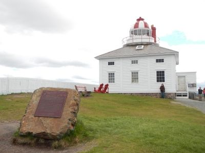
Cape Spear Lighthouse Marker
| 1 ► Newfoundland and Labrador, Avalon Peninsula, Newfoundland, Blackhead — Cape Spear Lighthouse — Le Phare du Cap Spear — |
| On Blackhead Road. | |||
| 2 ► Newfoundland and Labrador, Avalon Peninsula, Newfoundland, Blackhead — World War II Battery — Batterie del a IIième Guerre mondaile — Fort Cape Spear / Le fort du cap Spear — |
| Near Blackhead Road. | |||
| 3 ► Newfoundland and Labrador, Avalon Peninsula, Newfoundland, Ferryland — Colony of Avalon — La colonie d’Avalon — Sir David Kirke, c. 1597-1654 — |
| Near Newfoundland and Labrador Route 10, on the right when traveling north. | |||
| 4 ► Newfoundland and Labrador, Avalon Peninsula, Newfoundland, Ferryland — Ferryland — Population 717 (1996) — Settled 1621 • Inc. 1971 — |
| On Newfoundland and Labrador Route 10, on the left when traveling north. | |||
| 5 ► Newfoundland and Labrador, Avalon Peninsula, Newfoundland, Ferryland — The French Attack Ferryland — Les Français attaquent Ferryland — |
| Near Newfoundland and Labrador Route 10, on the right when traveling north. | |||
| 6 ► Newfoundland and Labrador, Avalon Peninsula, Newfoundland, Placentia — (Fort Royal) — Outer Defences / Défenses avancées — |
| Near Castle Hill Road. | |||
| 7 ► Newfoundland and Labrador, Avalon Peninsula, Newfoundland, Placentia — Castle Hill — |
| On Castle Hill Road close to Route 100 South. | |||
| 8 ► Newfoundland and Labrador, Avalon Peninsula, Newfoundland, Placentia — Castle Hill — |
| On Castle Hill Road close to Route 100 South. | |||
| 9 ► Newfoundland and Labrador, Avalon Peninsula, Newfoundland, Placentia — Fort Frederick — |
| On Main Street (Route 100 South) close to Orcan Drive, on the left when traveling south. | |||
| 10 ► Newfoundland and Labrador, Avalon Peninsula, Newfoundland, Placentia — Fort Royal (Plaisance) — le fort Royal — |
| Near Castle Hill Road. | |||
| 11 ► Newfoundland and Labrador, Avalon Peninsula, Newfoundland, Placentia — Port Royal and Castle Graves — Port Royal et Castle Graves — |
| Near Castle Hill Road. | |||
| 12 ► Newfoundland and Labrador, Avalon Peninsula, Newfoundland, St John's — First Transatlantic Wireless Signal — |
| On Signal Hill Road. | |||
| 13 ► Newfoundland and Labrador, Avalon Peninsula, Newfoundland, St. John's — (Royal Newfoundland Constabulary Monument) — |
| On Queens Road at Gower Street, in the median on Queens Road. | |||
| 14 ► Newfoundland and Labrador, Avalon Peninsula, Newfoundland, St. John's — 1892: The Great Fire — 1892: Le grand incendie — |
| Near Signal Hill Road. | |||
| 15 ► Newfoundland and Labrador, Avalon Peninsula, Newfoundland, St. John's — Bank of British North America — 1849 — |
| On Duckworth Street close to Soloman's Lane, on the left when traveling north. | |||
| 16 ► Newfoundland and Labrador, Avalon Peninsula, Newfoundland, St. John's — Battle of Signal Hill — La bataille de Signal Hill — |
| Near Signal Hill Road. | |||
| 17 ► Newfoundland and Labrador, Avalon Peninsula, Newfoundland, St. John's — Cabot Tower — La Tour Cabot — |
| Near Signal Hill Road. | |||
| 18 ► Newfoundland and Labrador, Avalon Peninsula, Newfoundland, St. John's — Fever Hospital — L’hôpital des maladies contagieuses — |
| On Signal Hill Road. | |||
| 19 ► Newfoundland and Labrador, Avalon Peninsula, Newfoundland, St. John's — Fishery — Le pêche — |
| Near Signal Hill Road. | |||
| 20 ► Newfoundland and Labrador, Avalon Peninsula, Newfoundland, St. John's — Former Bank of British North America — L’ancienne Bank of North America — |
| On Duckworth Street close to Soloman's Lane, on the left when traveling north. | |||
| 21 ► Newfoundland and Labrador, Avalon Peninsula, Newfoundland, St. John's — Former Newfoundland Railway Headquarters — L’ancien siège social du chemin de fer de Terre-Neuve — |
| On Water Street close to Job Street, on the left when traveling south. | |||
| 22 ► Newfoundland and Labrador, Avalon Peninsula, Newfoundland, St. John's — Herbert J. Russell, C.B.E. — |
| On Water Street close to Job Street, on the left when traveling south. | |||
| 23 ► Newfoundland and Labrador, Avalon Peninsula, Newfoundland, St. John's — Ice — Les Glaces — |
| Near Signal Hill Road. | |||
| 24 ► Newfoundland and Labrador, Avalon Peninsula, Newfoundland, St. John's — Mary Meager Southcott — (1862-1943) — |
| On Forest Road close to Taaffe's Lane, on the right when traveling west. | |||
| 25 ► Newfoundland and Labrador, Avalon Peninsula, Newfoundland, St. John's — Masonic Temple — 1894-1897 — |
| On Cathedral Street close to Gower Street, on the right when traveling west. | |||
| 26 ► Newfoundland and Labrador, Avalon Peninsula, Newfoundland, St. John's — Noon Day Gun — Canon de midi — |
| Near Signal Hill Road. | |||
| 27 ► Newfoundland and Labrador, Avalon Peninsula, Newfoundland, St. John's — O’Dwyer Block — 1847 — |
| On Water Street close to Beck's Cove, on the right when traveling north. | |||
| 28 ► Newfoundland and Labrador, Avalon Peninsula, Newfoundland, St. John's — Peacetime Use — Utilisation en temps de paix — |
| Near Signal Hill Road. | |||
| 29 ► Newfoundland and Labrador, Avalon Peninsula, Newfoundland, St. John's — Sir Robert Gillespie Reid — |
| On Water Street close to Job Street, on the left when traveling south. | |||
| 30 ► Newfoundland and Labrador, Avalon Peninsula, Newfoundland, St. John's — St. John the Baptist Anglican Cathedral — Cathédrale Anglicane St. John the Baptist — |
| On Church Hill close to Gower Street, on the right when traveling north. | |||
| 31 ► Newfoundland and Labrador, Avalon Peninsula, Newfoundland, St. John's — St. John’s Court House — Le Palais de justice de St. John’s — |
| On Water Street close to McMurdo's Lane, on the left when traveling north. | |||
| 32 ► Newfoundland and Labrador, Avalon Peninsula, Newfoundland, St. John's — Swiling — La chasse au phoque — |
| Near Signal Hill Road. | |||
| 33 ► Newfoundland and Labrador, Avalon Peninsula, Newfoundland, St. John's — Thompson Building — c 1847 — |
| On Water Street close to Beck's Cove, on the right when traveling north. | |||
| 34 ► Newfoundland and Labrador, Avalon Peninsula, Newfoundland, St. John's — Transatlantic Radio Signals — Le premier message radiotélégraphique transatlantique — |
| On Signal Hill Road. | |||
| 35 ► Newfoundland and Labrador, Avalon Peninsula, Newfoundland, St. John's — William Carson — 1770-1843 — |
| On Duckworth Street at Cathedral Street, on the left when traveling north on Duckworth Street. | |||
| 36 ► Newfoundland and Labrador, Central Newfoundland, Gander — Arrow Air Crash — The Silent Witness Memorial — Cross of Sacrifice — |
| On unnamed dirt road close to Trans-Canada Highway (Route 1), on the right when traveling south. | |||
| 37 ► Newfoundland and Labrador, Great Northern Peninsula, Newfoundland, Flower's Cove — Thrombolites or Living Rocks — |
| Near Newfoundland and Labrador Route 430, on the left when traveling north. | |||
| 38 ► Newfoundland and Labrador, Great Northern Peninsula, Newfoundland, Sally's Cove — Green Point — Cambrian-Ordovician Boundary / La limite Cambrien-Ordovicien — |
| Near unnamed road close to Newfoundland and Labrador Route 430. | |||
| 39 ► Newfoundland and Labrador, Great Northern Peninsula, Newfoundland, St Lunaire-Griquet — L’Anse aux Meadows — |
| Near Newfoundland and Labrador Route 436 close to Newfoundland and Labrador Route 430. | |||
| 40 ► Newfoundland and Labrador, Great Northern Peninsula, Newfoundland, St Lunaire-Griquet — The End of a Quest: L’aboutissement d’une quête — Fishing for the Past: À la recherche du passé — |
| Near unnamed road close to Newfoundland and Labrador Route 43. | |||
| 41 ► Newfoundland and Labrador, Great Northern Peninsula, Newfoundland, St. Anthony — Fox Point Lightouse — (Fishing Point) — |
| On West Street, on the left when traveling east. | |||
| 42 ► Newfoundland and Labrador, Great Northern Peninsula, Newfoundland, St. Anthony — Sir Wilfred Thomason Grenfell — 1865-1940 — |
| On West Street close to Hospital Road, on the right when traveling east. | |||
| 43 ► Newfoundland and Labrador, Great Northern Peninsula, Newfoundland, St. Anthony — St. Anthony — Population 2,996 (1996) — |
| On West Street, in the median. | |||
| 44 ► Newfoundland and Labrador, Humber Valley, Newfoundland, Corner Brook — Captain James Cook, R.N. — Le capitaine James Cook — |
| Near Mayfair Avenue. | |||
| 45 ► Newfoundland and Labrador, Humber Valley, Newfoundland, Corner Brook — Cook comes to Canada — |
| Near Mayfair Avenue. | |||
| 46 ► Newfoundland and Labrador, Labrador, L'Anse-au-Loup — L’Anse Amour Burial — Site funéraire de l’anse Amour — |
| On L'Anse Amour Branch Road close to Trans-Labrador Highway (Newfoundland and Labrador Route 510), on the right when traveling south. | |||
| 47 ► Newfoundland and Labrador, Labrador, L'Anse-au-Loup — The Diaphone — Lighthouse Trail — |
| Near L'Anse Amour Branch Road close to Trans-Labrador Highway (Newfoundland and Labrador Route 510), on the right when traveling east. | |||
| 48 ► Newfoundland and Labrador, Labrador, L'Anse-au-Loup — The Marconi Station — Lighthouse Trail — |
| On L'Anse Amour Branch Road close to Trans-Labrador Highway (Newfoundland and Labrador Route 510). | |||
| 49 ► Newfoundland and Labrador, Labrador, Red Bay — (The Moores Family Home) — |
| Near Trans-Labrador Highway (Newfoundland and Labrador Route 510), on the right when traveling north. | |||
| 50 ► Newfoundland and Labrador, Labrador, Red Bay — Basque Whalers in the Strait of Belle Isle — Les baleiners Basques dans la détroit de Belle Isle — |
| Near unnamed road. | |||
| 51 ► Newfoundland and Labrador, Notre Dame Bay, Newfoundland, Twillingate — Twillingate — Population 3,366 (1996) — |
| On Main Street close to Blanfords Lane, on the left when traveling east. | |||
| 52 ► Newfoundland and Labrador, Nunatukavut, Labrador, Channel-Port aux Basques — Port aux Basques - North Sydney — 1898 - 100 - 1998 — |
| On Trans Canada Highway (Newfoundland and Labrador Route 1), on the right when traveling south. | |||