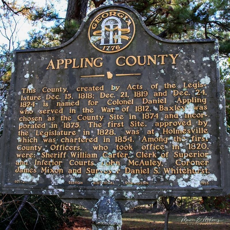
By Maureen McKinney, October 28, 2023
Appling County Marker
GEOGRAPHIC SORT Title Sort Marker Number Sort Marker Number Sort for Trails Publication Order Sort Publication Order Sort A Erected Year Sort Most Viewed Sort Most Recent-Interest Sort Most Recently Changed Sort SEE FAQ #33 FOR DESCRIPTIONS
On Post Road at South Main Street (U.S. 1), on the right when traveling west on Post Road.
On Golden Isles Highway (U.S. 341) at South Oak Street, on the right when traveling east on Golden Isles Highway.
On South Main Street (U.S. 441) at West Smith Avenue, on the right when traveling south on South Main Street.
On South Main Street (U.S. 221/441) just south of West Roberts Avenue, on the right when traveling south.
On U.S. 221 at Kinnaird Trail (County Road 29), on the right when traveling south on U.S. 221.
On East Carter Avenue at North Church Street, on the left when traveling east on East Carter Avenue.
On Salem Church Road (County Route 29) 0.5 miles east of U.S. 221, on the left when traveling east.
On South Pierce Street (U.S. 1/23) 0.4 miles south of Williams Avenue, on the right when traveling north.
On Dixon Street (State Highway 4) at East 12th Street, on the right when traveling south on Dixon Street.
On Georgia Route 37 at Clear Lake Road (County Route 121), on the right when traveling north on Georgia Route 37.
Near Millford Church Road 0.3 miles north of Route 216, on the left when traveling north.
On Main Street at Court Avenue, on the right when traveling north on Main Street.
On South Sheridan Street south of East Central Avenue (U.S. 319), on the right when traveling north.
On West Central Avenue (U.S. 319) at Main Street, in the median on West Central Avenue.
On Merrimac Drive at Jessamine Street, on the left when traveling south on Merrimac Drive.
Paid Advertisement
On West Central Avenue (U.S. 319) at North Grant Street (U.S. 129), in the median on West Central Avenue.
On East Pine Street at South Main Street, on the right when traveling east on East Pine Street.
On West Suwanee Street 0 miles west of North Gordon Street, on the left when traveling west.
On East Central Avenue (U.S. 319) at South Sheridan Street, on the right when traveling east on East Central Avenue.
On West Central Avenue (U.S. 319) at Grant Street (U.S. 129), in the median on West Central Avenue.
On Bethlehem Church Road 0.1 miles south of Broom Road, on the left when traveling south.
On East Pine Street just east of South Sheridan Street, on the right when traveling west.
On North Railroad Street just east of North Davis Street (U.S. 129), on the left when traveling east.
On North Davis Street (U.S. 129) at West Marion Avenue, on the left when traveling south on North Davis Street.
On South Davis Street (U.S. 129) at East Washington Avenue, on the right when traveling north on South Davis Street.
On West Washington Avenue at South Davis Street ( Route 76/125), on the right when traveling west on West Washington Avenue.
On North Main Street (U.S. 129) at Flat Creek Church Road, on the left when traveling north on North Main Street. Reported missing.
Near South Bartow Street at Johnson Alley, on the left when traveling north.
On South Davis Street (U.S. 129) at East Washington Street, on the right when traveling north on South Davis Street.
On Jefferson Street near West Washington Avenue, on the right when traveling south.
On North Davis Street (U.S. 129) at East Marion Street ( Route 76), on the right when traveling north on North Davis Street.
Paid Advertisement
On Jefferson Street just south of East Marion Avenue (State Route 76), on the right when traveling south.
On South Davis Street (Georgia Route 76/125) at West Washington Avenue, on the left when traveling south on South Davis Street.
On North Second Street at East Dykes Street ( Road 26/112), on the right when traveling north on North Second Street.
On North Second Street at East Dykes Street ( Road 26/112) on North Second Street.
On North Second Street at East Dykes Street ( Road 26/112), on the right when traveling north on North Second Street.
On North 2nd Street (Business U.S. 23) 0 miles east of Cherry Street, on the left when traveling east.
On Golden Isles Highway (U.S. 23) 0.3 miles north of Coley Station Road ( Route 112), on the right when traveling north.
On North 2nd Street (Business U.S. 23) 0 miles east of Cherry Street, on the left when traveling east.
On Longstreet Church Road 0.5 miles south of Broadhead Road, on the left when traveling north.
On North 2nd Street (Business U.S. 23) 0 miles east of Cherry Street, on the left when traveling east.
On North 2nd Street (Business U.S. 23) 0 miles east of Cherry Street, on the left when traveling east.
On Dykes Street SE (Georgia Route 26) north of 8th Street SE, on the right when traveling north.
On U.S. 82 0.4 miles west of Petty Crossing Road, on the right when traveling east.
On Main Street (U.S. 301) near Brantley Street, on the right when traveling north.
Near George Kirkland Road/Mineral Springs Road 0.1 miles east of Browntown Road, on the left when traveling east.
Paid Advertisement
On 1st Avenue 0.1 miles south of Strickland Road, on the right when traveling south.
On Beasley Road (County Route 79) 0 miles Grooverville Road (County Route 275), on the left when traveling north.
Near Liberty Church Road (County Route 94) 0 miles north of Grooverville Road (County Route 275), on the right when traveling west.
On Campground Road 0 miles east of Adel Highway ( Route 76), on the left when traveling south.
On Adel Highway (Georgia Route 76) at Coffee Road, on the right when traveling north on Adel Highway.
On 2nd Street just north of Main Street, on the right when traveling north.
On Radford Road (County Route 114) 0.8 miles west of Madison Highway ( Route 333), on the left when traveling west.
On Bethel Church Road 1.5 miles south of Route 122, on the left when traveling south.
On Bethlehem Church Road at Grooverville Road, on the left when traveling south on Bethlehem Church Road.
On East Screven Street (U.S. 84) at South Court Street (U.S. 221), on the right when traveling west on East Screven Street.
On East Screven Street at South Court Street, on the right when traveling west on East Screven Street.
On E. Screven Street at S. Court Street, on the right when traveling west on E. Screven Street.
On South Court Street (U.S. 221) at West Screven Street (U.S. 84), on the right when traveling south on South Court Street.
On Moultrie Highway (Georgia Route 333) at Coffee Road, on the left when traveling south on Moultrie Highway.
On E. Screven Street at S. Court Street, on the right when traveling west on E. Screven Street.
On East Screven Street (U.S. 221) just east of South Jefferson Street, on the right when traveling east.
Paid Advertisement
On E. Screven Street at S. Court Street, on the right when traveling west on E. Screven Street.
On Thomasville Road (U.S. 84) 0 miles west of South Laurel Street, on the right when traveling east.
On U.S. 80, on the right when traveling east.
On U.S. 80 near U.S. 280, on the right when traveling south.
On U.S. 280 at Black Creek Church Road, on the left when traveling south on U.S. 280.
On Belfast-Keller Rd, on the left when traveling west.
On South College Street (Georgia Route 67) near Courthouse Street, on the right when traveling north.
On South College Street (Georgia Route 67) near Courthouse Street, on the right when traveling north.
On W. Gibson St. at S. College St., on the right when traveling east on W. Gibson St..
On Ford Avenue (State Highway 144) at Coastal Highway (U.S. 17), on the right when traveling east on Ford Avenue.
Near Fort McAllister Road at Savage Island Road.
On Bryan Neck Road (Georgia Route 144) at Carver School Road, on the left when traveling south on Bryan Neck Road.
On Bryan Neck Road (Georgia Route 144) 0.1 miles south of Belfast River Road, on the right when traveling south.
Near Fort McAllister Road.
On Henry Ford Avenue (Georgia Route 144) at Pinecrest Avenue, on the right when traveling east on Henry Ford Avenue.
Near Fort McAllister Road, on the right when traveling east.
Paid Advertisement
Near Fort McAllister Road.
Near Fort McAllister Road.
Near Fort McAllister Road.
On Henry Ford Avenue (Georgia Route 144) at Hill Street, on the right when traveling south on Henry Ford Avenue.
On Henry Ford Avenue (Georgia Route 144) at Ellis Drive, on the right when traveling south on Henry Ford Avenue.
Near Fort McAllister Road.
On Ford Avenue (Georgia Route 144) south of Ivey Street, on the right when traveling south.
On Ford Avenue (Georgia Route 144) at Cherry Street, on the right when traveling south on Ford Avenue.
On U.S. 144 at State Road 67, on the left when traveling south on U.S. 144.
On Fort McAllister Road (State Highway 144 Spur) at Bryan Neck Road (State Highway 144), on the right when traveling east on Fort McAllister Road. Reported permanently removed.
On Fort McAllister Road (State Highway 144 Spur) at Bryan Neck Road (State Highway 144) when traveling east on Fort McAllister Road.
On Ford Avenue (State Highway 144) at Coastal Highway (U.S. 17), on the right when traveling east on Ford Avenue.
Near Fort McAllister Road.
Near Fort McAllister Road.
Paid Advertisement
On Bryan Neck Road (Georgia Route 144) 0.1 miles south of Belfast River Road, on the right when traveling south.
On Bryan Neck Road (Georgia Route 144) 0 miles north of Carver School Road, on the left when traveling south.
Near Fort McAllister Road (Georgia Route 144 Spur) at Savage Island Road.
On Fort McAllister Road (State Highway 144 Spur) 2.1 miles east of Bryan Neck Road (State Route 144), on the left when traveling east.
On State Highway 144 at County Route 67, on the right when traveling west on State Highway 144.
︽
2009 entries matched your criteria. The first 100 are listed above.
Next 100 ⊳