(The Oregon Trail kiosk houses thirteen panels which deal with Native Americans, the Fur Trade, the Oregon Question, Oregon Fever, and trials of the Oregon Trail.)
Pathway to the "Garden of the World"
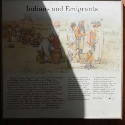
Excitement filled the . . . — — Map (db m107234) HM
About 60 feet above this marker a line of rocks marks the old Trappers and Emigrants Trail from Trinity River to Scott Valley. This route may have been used as early as 1829 by Hudson’s Bay trappers and others prior to the building of this road in . . . — — Map (db m57898) HM
(Twelve panels dealing with Oregon Trail related topics are found at this kiosk)
Pathway to the "Garden of the World"
Excitement filled the air May 22, 1843 as nearly one thousand Americans left Missouri toward new . . . — — Map (db m112193) HM
World War I plaque
In Memory of
Earl Blackden
Owen Johnson
R K Wilmot
Foresters Who
Fell in the
World War
1917-1918
World War II plaque
In Memory Of O. S. C.
Foresters
Who Lost Their Lives
In World War II . . . — — Map (db m113266) WM
Many of Oregon’s early transportation routes resulted from the efforts of enterprising pioneers like the Boone family of Clackamas County. In 1846 Alphonso Boone, grandson of Daniel Boone, emigrated to Oregon via the Applegate Trail with his large . . . — — Map (db m127162) HM
Seaside
Devastating waves called “tsunamis” can strike Oregon’s coast at any time. These giant waves are caused by great undersea earthquakes. Such earthquakes can occur along the Cascadia Subduction Zone, one of the largest . . . — — Map (db m113871) HM
The Hammond Marina was featured in the final scene of the movie when young Jesse helps free his killer whale friend, Willy, by leading the orca to jump over the harbor wall to freedom and into the ocean beyond.
Did You Know?
Keiko, a 13 . . . — — Map (db m246644) HM
The Devon privateer took his flotilla from Plymouth Harbor August 5, 1577 bound for the River Plate.
He raided Spanish shipping and treasure houses around South America, including Valparaiso, Peru and Acapulco roads.
June 5, 1579 the renamed 78 . . . — — Map (db m114250) HM
Jedediah Smith's explorations in the American West began when he was 21 and lasted until his death at age 32. He crisscrossed the region in search of beaver pelts and new travel routes. His travel journals became a foundation for the first . . . — — Map (db m176970) HM
Smith, Jackson & Sublette Beaver Trappers
-- In Memory of --
Thomas Daws · John Gaither · John Hanna · Abraham Laplant · Joseph Lapoint · Emmanuel Lazarus · Toussaint Marechal · Martin McCoy · Joseph Palmer · Peter Ranne · . . . — — Map (db m237193) HM
Long before the first Euro-American emigrants trekked westward, this road was a trail used by the Takelma and Shasta Peoples as a trade route. With the arrival of settlers and gold-seekers, the trail quickly became a wagon road called ‘Indian . . . — — Map (db m244111) HM
In memory of
Burrell M. Baucom
an officer and soldier, brave of heart, sincere of purpose and faithful to trust who fell here July 1, 1933 in performance of his duty.
This tablet is inscribed by his fellow members of the
Oregon . . . — — Map (db m112853) HM
In 1845 Elijah Bristow and his wife (Susannah Gabbart Bristow) left their home in Illinois and traveled overland to California. They came to Oregon in the spring of 1846, following the Hudson's Bay trappers' route to the northern Willamette Valley. . . . — — Map (db m99220) HM
About 18 September 1860, 26 survivors of the Utter disaster arrived south of here. Only 10 remained when an army relief expedition arrived 5 weeks later.
On September 9 & 10, in Idaho, the Elijah P. Utter wagon train suffered a two-day . . . — — Map (db m106943) HM
The prominent monolith across the river was named Beacon Rock by Lewis and Clark, November 2, 1805. It marked the beginning of tidewater for early river explorers who used it for a landmark in their journeys. The Indians say that when the Chinook . . . — — Map (db m34643) HM
Captain George Vancouver in a voyage of exploration to the Northwest coast of America ordered by the British Admiralty Office assigned Lieutenant William Robert Broughton, Commander of H.M.S. Chatham, to explore the navigable waters of the Columbia . . . — — Map (db m34495) HM
On October 30, 1792 off the point in the Columbia River where the Sandy empties its waters, the boat crew from the H.M.S. Chatham (Vancouver's Voyages) were the first white men to sight the snowclad peak which Lt. Wm. R. Broughton named Mt. Hood in . . . — — Map (db m38388) HM
The Oregon Trail crossed the hazardous Deschutes River at this point by floating the prairie schooners and swimming the livestock. An island at the river mouth was often utilized when the water was high and the ford dangerous. Pioneer women and . . . — — Map (db m34575) HM
Before a network of dams controlled the Columbia River it was a raging torrent. Here at Wyam Falls, known today as Celilo Falls, a vertical drop of more than 20 feet and sheer basalt bluffs on either shore forced the river into seething, boiling . . . — — Map (db m34581) HM
"From the numerous miners and settlers that are pressing into their country they are suffering many grievous wrongs that call for the immediate interference of the Government. Within the last six months four of their villages have . . . — — Map (db m176836) HM
Dedicated to the travelers on Old Oregon Trail 1832-1843 when it passed thru
Walla Walla Valley. Robert Newell and Joe Meek brought wagons to Fort Walla Walla in 1840. White, Lovejoy & Hastings led the first emigrants in 1842. Whitman, Applegate . . . — — Map (db m126012) HM
January 25, 1951 Coos Bay, Oregon May 30, 1975 Eugene, Oregon American records held by Steve Prefontaine at the time of his death May 30, 1975: National Prep Record 2 Miles — 8:41.5, April 25, 1969, Corvallis, Oregon Outdoor 2,000 Meters . . . — — Map (db m157709) HM
Mount Union Cemetery is situated on Reuben and Mary Jane Shipley, one of Oregon's earliest Black pioneer couples. Reuben was born into slavery in Kentucky and was brought to Oregon by his enslaver, Robert Shipley, in 1853. In return for driving . . . — — Map (db m234513) HM
Oregon City - supply point for pioneer emigrants was first located as a claim by Dr. John McLoughlin in 1829. The first provisional legislature of the Oregon Country was held here in 1843 and land and tax laws formulated. Oregon City was the . . . — — Map (db m8700) HM
Chief factor of the Hudson’s Bay Company at Fort Vancouver, philanthropist, and founder of Oregon City. The land on the east bank of the Willamette River at the falls was claimed by Dr. McLoughlin and the Hudson’s Bay Co. in 1828-29. First called . . . — — Map (db m8669) HM
(Note: marker is comprised of four panels)(top left panel)
The rugged shore of the Central and Northern Oregon Coast is backed by the Coast Range Mountains, remnants of a chain of volcanic islands that collided with the North . . . — — Map (db m177132) HM
Entering California over the Applegate and Lassen trails, a party of Oregonians, captained by Peter H. Burnett, arrived here in autumn of 1848 to establish the town of Oregon City. Burnett, little more than a year later, became the first civil . . . — — Map (db m100600) HM
In 1864 the Strang family moved to Oregon City. The institution date of the Oregon City Cemetery is unknown, the oldest grave is believed to be August 16, 1878. William H. Strang granted to the inhabitants of Oregon City and vicinity this piece of . . . — — Map (db m61706) HM
Constructed in 1858, this was the route of the Crescent City Turnpike. Following the present Elk Valley Road to Old Camp Lincoln, it then crossed the ridge, forded Smith River to low divide, and continued to Jacksonville, Oregon, by way of various . . . — — Map (db m176819) HM
Erected
by
the crew of the
U.S.S. Oregon
In memory of
their shipmate privates
Harry Fisher,
Albert Turner,
Robert E. Thomas,
Charles B. King,
U.S. Marine Corps
killed in action on the
Tartar Wall
of
Peking, . . . — — Map (db m91852) HM WM
“The pioneers in their journeys marked the roads and trails so that others recognizing them might safely follow.”
This spot marks the location of the California – Oregon Road, main artery of travel of the pioneers blazed by them in the . . . — — Map (db m70338) HM
A pack trail in 1851, Greathouse & Co. muled passengers by 1854. James E. Carr contracted by the California Stage Co., finished the last six miles of road from Trinity River to here, Sept. 14, 1860. The first daily mail and passenger stage, driven . . . — — Map (db m56234) HM
Built in 1860, the Oregon Creek Covered Bridge was floated from its foundations by the flood waters from the breaking of English Dam in 1883. It was restored to place by using ox teams and log rollers, but turned end for end in the process. — — Map (db m65967) HM
We Were Always Here, 2012
Old-growth Western red cedar, Port Orford cedar, old-growth Douglas fir, oak, maple, stain, sealer
Commissioned from the artist 2011 (26/8852)
In creating these two poles from a single old-growth cedar . . . — — Map (db m113974) HM
Along this historic trail, from 1841 to 1861, traveled the greatest land migration in history. Nearly half a million pioneers came to settle America's Northwest. One out of every eight would perish along the way. — — Map (db m125859) HM
Between 1843 and 1869 over 300,000 emigrants fulfilled Americas's Manifest Destiny by voluntarily relocating to Oregon and California. Their nearly 2,000 mile journey along game trails long used by the early Native Americans would become known as . . . — — Map (db m119239) HM
Indians, trappers, and emigrants who came this way before 1900 used a more direct route to get between Boise and Glenns Ferry. Their road still can be seen at Bonneville Point 5 miles from here. Following close to a line of hills bordering a . . . — — Map (db m22181) HM
Placed here by Ezra Meeker on May 9, 1906
Pioneer • Preservationist • Visionary
Ezra Meeker was largely responsible for locating and preserving the Old Oregon Trail. To commemorate the centennial of this monument, a time capsule of . . . — — Map (db m128544) HM
The Oregon Trail is still clearly visible coming off the rimrock across the river. Here the west bound emigrants after 1840 came gratefully down into this green valley.
The first cart passed here with Spalding and Whitman, pioneer missionaries, . . . — — Map (db m22639) HM
(Five panels in the kiosk deal with the history of Goodale's Cutoff and the surrounding area)
Idaho's Emigrant Trails
Westward-bound emigrants entered Idaho after crossing Thomas Fork Valley. They soon encountered the climb . . . — — Map (db m110138) HM
After the arrival of the first settlers of Chesterfield in 1875, covered wagon trains continued to use the Old Oregon Traill of 1846 which passed this point. Tired discouraged and ill, travelers arrived here from early spring to late autumn. Local . . . — — Map (db m124580) HM
A perilous ford at Three Island State Park was a formidable Oregon Trail barrier. Those who could not cross here faced a longer, more difficult southern route. No other ford between Missouri and Oregon troubled them so much. This was their largest . . . — — Map (db m31677) HM
Thursday August 14 "...We had a squally time ascending the bluffs, which are severaly hundred feet high. We passed from a hill to the side of a bluff, upon a high narrow ridge of just sufficient width upon the top for the wagon road, the . . . — — Map (db m125733) HM
Directly in front of you, the Oregon Trail descends the steep bluff to the Snake River. The trail lies parallel to and directly above the major road scar that is easily seen. On sunny days, the trail is visible to the keen eye.
While the . . . — — Map (db m125725) HM
(There are five historical panels in this kiosk:)
Idaho's Emigrant Trail
Westward-bound emigrants entered Idaho after crossing Thomas Fork Valley. They soon encountered the climb and descent of Big Hill, witnessed nature's . . . — — Map (db m124029) HM
In this defile on August 10, 1862 a band of Shoshone Indians ambushed an Immigrant Train bound for Oregon killing nine white men and wounding six. — — Map (db m124159) HM
Immediately west of here you will cross a small canyon that Oregon Trail emigrants regarded as their most dangerous exposure to Indians.
After 1854, they had good reason to be alarmed. Wagon traffic has ruined important traditional Indian . . . — — Map (db m124148) HM
(There are five historical panels in this kiosk:)
Idaho's Emigrant Trails
Westward-bound emigrants entered Idaho after crossing Thomas Fork Valley. They soon encountered the climb and descent of Big Hill, witnessed . . . — — Map (db m124037) HM
From the early 1840s to 1865 the Oregon-California Trail was the most important route for settlers traveling west. Wagon trains camped at the Iowa, Sac and Fox Mission to take advantage of the spring and the blacksmith. They were followed in the . . . — — Map (db m47930) HM
Beginning in 1849, there plodded up the southern slope of Mount Oread a vast emigration bound for the golden land of California. One branch of the great California and Oregon Trail thus passed over the very ground now part of the university . . . — — Map (db m77573) HM
Both the Santa Fe and Oregon Trails crossed here, northeast to southwest, beginning 1821. The trails took separate courses farther west. A route through Kansas Territory was opened north of here in the 1830's after the founding of Westport, Mo. Long . . . — — Map (db m20213) HM
Westport
Westport, along with Independence, was a major outfitting point for the Santa Fe, Oregon, and California Trails. Founded in 1834 by John C. McCoy and platted around the trading post he built the previous year, Westport's early . . . — — Map (db m50723) HM
This cut is part of the old Santa Fe Trail. Many years ago the Missouri River came near this site and thousands of early settlers were ferried here. Their wagons and teams climbed this hill and headed west toward Santa Fe and the Oregon . . . — — Map (db m66712) HM
The stone monuments to the west mark the trace of the original road leading up from the river. For many pioneers, traders, settlers and soldiers, this was the beginning of the Oregon and Santa Fe Trails leading to the Far West. The steamboat and . . . — — Map (db m66713) HM
Six miles northwest is Alcove Springs, named in 1846 by appreciative travelers on the Oregon trail who carved the name on the surrounding rocks and trees. One described the Springs as "a beautiful cascade of water... altogether one of the most . . . — — Map (db m79113) HM
Dedicated to
Gregory M. Franzwa
1926 - 2009
Friend of Alcove Spring
Historian-Writer-Publisher
Founder of the
Oregon-California Trails Association — — Map (db m79119) HM
Historians have estimated that between 250,000 and 300,000 emigrants used the Oregon Trail between 1840 and 1869. At least 30,000 emigrants died along the Oregon Trail, leaving an average of 15 graves for every mile of the trail. Disease, . . . — — Map (db m80946) HM
From the 1830's to the 1870's, the 2,000-mile road connecting Missouri river towns with California and Oregon was America's greatest transcontinental highway. Several routes led west from the river, converging into one trail by the time the Fort . . . — — Map (db m80927) HM
Warwick/Oregon Warwick flourished for some 50 years and was succeeded by Oregon. Both were early shipping ports. Flatboats, during Warwick era, and later steamboats, at Oregon, ran regularly between here and New Orleans. This point was at head . . . — — Map (db m105463) HM
[top panel]
500 million years ago limestone was forming in ancient seas. No plants or animals were found on the land at that time. Primitive plants and animals did live in the earth's oceans, and the molecular building locks for our very own . . . — — Map (db m219250) HM
The property comprising the present day Oregon Ridge Park was first patented in the early l8th century and was primarily used for agricultural purposes. During the 1830's iron ore and marble stone were discovered on the property and its agricultural . . . — — Map (db m219132) HM
The history of the National Institutes of Health and the mission of the Lister Hill National Center for Biomedical Communications inspired artist Kenneth Snelson to create this elegantly angular metal sculpture. The artwork's modular . . . — — Map (db m234876) HM
Each spring thousands of emigrants camped in these hills and meadows waiting for new grass to support their teams along the trail. Wagons lined St. Joseph streets to the east waiting for two to three days to be ferried from this point. The settlers . . . — — Map (db m47467) HM
This monument honors
the pioneer spirit of
those courageous men
and women who by
their heroic trek across
the continent established
homes and civilization
in the Far Northwest — — Map (db m34753) HM
From the late 1830s and into the 1860s, thousands of traders, emigrants, and gold prospectors passed this way. After crossing the Big Blue River, covered wagons struggled up this hill due to the mud left behind from torrential spring downpours. Over . . . — — Map (db m199357) HM
Oregon and California National Historical Trails
The Oregon and California Trails were pathways to the Pacific for fur traders, gold seekers, missionaries, and emigrants. For 20 years, beginning in 1841, an estimated 300,00 emigrants . . . — — Map (db m206802) HM
[side 1] Here in the extreme southern Missouri Ozarks, Oregon County was organized in 1845, and named for the Oregon Territory of the Far West. One of 11 counties along the Arkansas border, Oregon is in a region long roamed . . . — — Map (db m179894) HM
Named for the year it was built, the Oregon Short Line 1903 was constructed for $16,685 as an executive rail car for the Vice President of the Union Pacific. In reference to E.H. Harriman's Presidential rail car, the Arden, which was built in 1900, . . . — — Map (db m123346) HM
In 1905 Union Pacific officials began construction of a branch line in the pine-forested wilderness from Ashton, Idaho, to the western edge of Yellowstone Park. As the final tracks were laid in 1907, Samuel P. Eagle, Alex Stuart, Charles Arnet and . . . — — Map (db m123342) HM
Byway 136 was designated the Heritage Highway in part because of the many historic trails that are now part of it. You are standing on the historic De Roin Trail. The De Roin Trail began at the Missouri River port town of Brownville on the eastern . . . — — Map (db m47623) HM
Travelers reached this point over the trail you see stretching out across the prairie to the southeast. They left the last real settlement at Westport Landing or at Independence, some 600 miles from here. Most of them took about 40 days to . . . — — Map (db m87332) HM
Scotts Bluff, the dramatic series of clay and sandstone highlands surrounding you, is known chiefly as a landmark on the old Oregon Trail. Emigrants heading west encountered the bluffs after a six to eight-week trek across the monotonously flat . . . — — Map (db m174254) HM
Honoring these and all the thousands who lie in nameless graves along the trail. Faith and courage such as theirs made America. May ours preserve it. — — Map (db m78704) HM
From Independence and Westport (Kansas City) Missouri to the Columbia River. Route of the first Oregon Colonists, the trail of trappers and traders as early as 1830. A main road to the gold fields and western military posts. The path of the Pony . . . — — Map (db m206998) HM
Was a manufacturing center. Two creeks powered a grist mill in the 18th century; wire, fulling, and paper mills in the 19th century. — — Map (db m119204) HM
1852 entries matched your criteria. The first 100 are listed above. Next 100 ⊳
* Inflectional forms of words are their plurals, singulars, and possessives as well as gramatical tenses and similar variations.