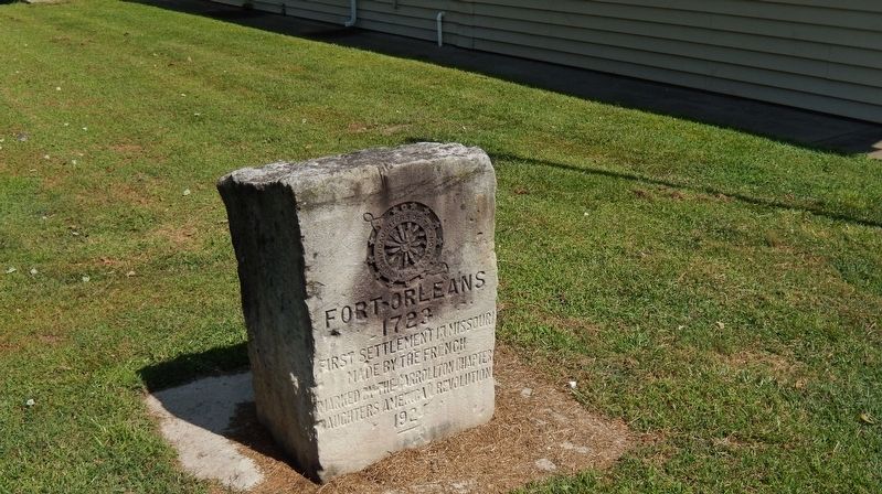
On Jefferson Street at 7th Street, on the right when traveling west on Jefferson Street.
Fort Orleans, first European post in the Missouri Valley, was built by the French explorer Etienne Véniard De Bourgmond on the Missouri River close by, a few miles above the mouth of the Grand, 1723-24. The exact location of the fort is not . . . — — Map (db m132000) HM
On Oct. 23, 1838, about 800 Potawatomi Indians camped near here on the forced removal from Indiana to Kansas. They camped at Thomas' encampment. Having marched 10 miles after ferrying the Grand River. Wet bottom lands and severe cold made the march . . . — — Map (db m198473) HM
On West Broadway Street (U.S. 24) east of South Polk Street, on the left when traveling east.
The World's Largest Pecan was built by George and Elizabeth James, in 1982. It was a tribute to a large, hardy, northern pecan that they found on their farm, James Pecan Farm, Inc. in the early 1950's. This patented nut, the starking hardy giant, . . . — — Map (db m198479) HM
Near South Polk Street near East Mulberry Street, on the right.
On Oct. 22, 1838, about 800 Potawatomi Indians began ferrying the Grand River as they walked from Indiana to Kansas on the forced removal. By dark all the Indians and many of the wagons were over the river and ferried the rest the next day. — — Map (db m198471) HM
Near West Bridge Street east of North Park Street, on the left when traveling east.
Born in Prince Edward County, Virginia September 11, 1809 Resided in Chariton County Missouri 1831-1865 Speaker Of the House of Representatives Of Missouri General Assembly 1840-1844 Elected to Congress 1844 Participated in War with Mexico 1846-1848 . . . — — Map (db m131899) HM WM
On West Jackson Street (U.S. 24) east of South Cherry Street, on the right when traveling east.
Founded, 1832, by Englishman James Keyte, Keytesville is the judicial seat of Chariton County. First seat of the county, organized in 1820, was "Old" Chariton laid out, 1817, near the mouth of the Chariton River by Duff Green, editor, politician. . . . — — Map (db m131898) HM
Near South Broadway 0.1 miles north of East 9th Street, on the right when traveling north.
With the faith and courage of
their forefathers who made
possible the freedom of these
United States
The Boy Scouts of America
dedicate this copy of the
Statue of Liberty as a pledge
of everlasting fidelity and
and loyalty
40th . . . — — Map (db m89550)
Within two hours, Col. David Moore's pro-Union Home Guard claimed victory over Col. Martin Green's pro-secessionist State Guard. After a short pursuit, Moore's men returned to care for their 23 casualties. That afternoon, the State Guard returned . . . — — Map (db m149960) HM
In the early 1860s, the prospect of war divided Missouri. Many of Missouri's settlers came from Southern states. Some owned enslaved people and many held strong views favoring slavery or "Southern rights." Despite this, a statewide convention held . . . — — Map (db m149943) HM
Isaac Gray platted the town of Athens in 1844 and built the first grist and flour mill on the Des Moines River under the management of Charles Toms. Arthur Thome purchased the mill in 1846 and added a sawmill operation. In 1849, Thomes sold . . . — — Map (db m149836) HM
On County Road CC at County Road 81 on County Road CC.
Aug. 5, 1861
Northernmost battle west
of Mississippi River
"Only when man's differences
have been resolved can he
rise to his rightful place"
Robert Eisenhart — — Map (db m149834) HM WM
Near County Road 81 (County Highway 81) at County Highway CC, on the right when traveling west.
By the 1850s the town had expanded and commercial buildings were being constructed on top of the bluff at Athens. A list of businesses and organizations (circa 1853-1860) reveals the extent of the town's growth.
Wm.B. Armstrong, general . . . — — Map (db m150597) HM
Home Guards were groups of pro-Union men who stayed close to their communities to protect against secessionists. These men seldom had army-issued weapons and served without pay.
David Moore recruited and trained the First Northeast Missouri . . . — — Map (db m149939) HM
Near County Road 81 0.2 miles east of County Road CC, on the right.
Some of the heaviest fighting during the Battle of Athens on Aug. 5, 1861, occurred around Jane Gray's house and the nearby cornfield. According to eyewitnesses, several bullets struck the home during the fighting.
Gray's house stood on this . . . — — Map (db m149832) HM
In the spring of 1861, pro-Southern Missouri Gov. Claiborne F. Jackson called up the Missouri State Guard to oppose pro-Union Home Guard and U.S. Army troops. Martin Green, a Lewis County judge, farmer and sawmill operator, answered the call by . . . — — Map (db m149961) HM
Located at the northwest corner of Thome and Spring streets, the store was one of six general stores operating in Athens prior to the Civil War. It was an ideal commercial site because of its location in the Spring Street business area on the Thome . . . — — Map (db m149935) HM
Arthur Thome, an immigrant from Kentucky, built this house in 1853. Joseph Benning acquired it in 1858.
A cannonball fired from the artillery of the pro-Confederate Missouri State Guard hit the house during the Aug. 5, 1861 Battle of Athens. . . . — — Map (db m149835) HM
On State Highway CC at County Road 81, on the left when traveling north on State Highway CC.
A. 5:30 a.m.: The roar of State Guard cannons began the Battle of Athens. Most of the shot flew over the heads of the Home Guard troops, though one struck the home of Joseph Benning and another blasted the depot across the river at Croton, Iowa. . . . — — Map (db m149946) HM
On North Johnson Street (Missouri Route 81) north of East Court Street, on the right when traveling north.
Missouri's first northern border county, organized in 1836, is named for explorer William Clark. In 1839, Iowa Territory and the State of Missouri mobilized troops on the nearby border in a boundary dispute called the Honey War for the bee trees . . . — — Map (db m144553) HM
Near County Road 188 north of County Road 200, on the right when traveling north.
Archaeological investigations at the Iliniwek Village are critical for a number of reasons. While several known Illinois villages have been excavated, Iliniwek is the earliest and provides information unique to the earliest phases of culture . . . — — Map (db m290817) HM
Near County Road 188 north of County Road 200, on the right when traveling north.
Historic Accounts
Several early explorers left accounts of Illinois lifeways. Foremost among these was Sieur Pierre Deliette, nephew of Henri de Tonti, who lived in the Illinois Country for over 3o years between 1687 and ca. 1721. His memoir . . . — — Map (db m290884) HM
Near County Road 188 north of County Road 200, on the right when traveling north.
On this property is the site of a village once inhabited by Indians of the Iliniwek Tribe. The liniwek, or Illinois, were one of the three most significant Indian groups occupying Missouri at the time of first European contact. It is the only . . . — — Map (db m290815) HM
Near County Road 188 north of County Road 200, on the right when traveling north.
For many years, the Indians of the interior had spoken to Europeans of "a great river named Mesippi." In 1672, Jean Talon, assistant to the Governor-General of New France, authorized an expedition to find and explore the unknown river. He . . . — — Map (db m290886) HM
Near County Road 188 north of County Road 200, on the right when traveling north.
Where Did The Illinois Originate?
We know little about the Illinois before their early encounters with Europeans. They belong to the same language family (Central Algonquian) as the Miami, Sac, Fox, Kickapoo, Pottawatomi, and Mascouten. We . . . — — Map (db m290813) HM
Near County Road 188 north of County Road 200, on the right when traveling north.
When first contacted by Europeans in their own territories, the Illinois numbered about 12,500 and were located in several villages scattered from Lake Superior to the Arkansas River. The largest of these was the village site you are . . . — — Map (db m290811) HM
Near County Road 188 north of County Road 200, on the right when traveling north.
Imagine living in a long, wide house with 26 relatives. Perhaps your parents, brothers and sisters, grandparents, aunts and uncles and cousins all live under the same roof.
The members of the Illinois at Iliniwek lived in just this manner in . . . — — Map (db m286623) HM
On Cherry Street north of 3rd Street, on the right when traveling north.
Placed here on March 17, 1981 by Frank McQuinn, John Pete O'Connell, and Jim O'Connor in celebration of the 1st Annual St. Patrick's Day Parade as a symbol dedicated to honor the Irish families that helped settle this area of Missouri. — — Map (db m67374) HM
On North Walnut Street (Business Interstate 35) at East 2nd Street, on the left when traveling south on North Walnut Street.
Abraham Lincoln
1809 - 1865
16th President of the United States
In 1859, the Hannibal & St. Joseph Railroad was the first to cross Missouri. That same year a little-known attorney from Illinois was traveling through Missouri by train. . . . — — Map (db m221274) HM
On U.S. 69 north of 1st Street, on the right when traveling north.
In the 1920's Cameron boasted over 40 trains a day and three active stations, including the elaborate Cameron Junction, described as one of the most popular and elegant eating houses in the West.
Two Cameron men are credited with initiating the . . . — — Map (db m86717) HM
On North Cherry Street north of West 3rd Street, on the right when traveling north.
In 1928, here at the Rock Island Railroad Depot, the Republican nominee for President was in Cameron. Local bridge builder J.C. Dildine and wife Rose, a member of the Republican State Committee, encouraged Hoover make a rear platform talk. But after . . . — — Map (db m221293) HM
On Cherry Street at 3rd Street, on the right when traveling south on Cherry Street.
The memorial tree planted nearby
is dedicated by the Rock Island
in affectionate memory of
John T. Walker
who by his industry courage and
loyalty through every vicissitude
signally aided in the development
of the
Chicago Rock . . . — — Map (db m67375) HM
On North Chestnut Street north of West 3rd Street, on the left when traveling north.
Lee Purcell
Actress, Producer
Lee Purcell was just beginning her acting career in 1969 when she landed her first starring role in a film titled ”Adam at 6 A.M.” Produced by legendary actor Steve McQueen’s Solar Productions, McQueen himself . . . — — Map (db m223040) HM
On Park Avenue 0.4 miles west of South Chestnut Street, on the right when traveling north.
Rutherford B. Hayes
1822—1893
19th President of the United States
In 1879, things were different when the sitting President Rutherford B. Hayes and his friend General William Tecumseh Sherman stopped at the Junction Depot near Second and . . . — — Map (db m223033) HM
On Park Avenue at Seminary Avenue, on the right when traveling north on Park Avenue.
William Jennings Bryan
1860 - 1925
Attorney, Politician, Orator,
Three-Time Presidential Nominee
The Chautauqua movement of the early 20th century brought internationally known
figures to rural America. One such notable at Cameron’s . . . — — Map (db m223042) HM
On S. Chestnut Street at Seminary Street, on the right when traveling north on S. Chestnut Street.
Harry S. Truman
1884-1972
33rd President of the United States
Harry S. Truman first came to Cameron while campaigning for Senate in 1934. His stage was a flatbed truck on Third Street. A few years later, in 1940, Truman spoke before . . . — — Map (db m223048) HM
On Third Street at Walnut Street (aka Hwy 69 or business route I-35), on the left when traveling west on Third Street.
Jesse James
1847 - 1882
Outlaw
In the years following the Civil War, Jesse James visited crime and mayhem on this territory. Banks and trains were favorite targets. The outlaw was a frequent visitor to Cameron, but never committed a . . . — — Map (db m223051) HM
On North Main Street south of East Maple Street, on the right when traveling north.
Once forming part of Missouri's western boundary, Clinton County was organized in 1833 and named for N.Y. Governor DeWitt Clinton. It lost its boundary status in 1837 when the Indian Platte Purchase territory extended the State border to the . . . — — Map (db m198965) HM
On North Main Street at East Locust Street, on the right when traveling north on North Main Street.
To those from Clinton County who have served and are serving in the Armed Forces of the United States. Also in memory of those who served in wars and conflicts prior to and inbetween those listed below.
Revolutionary War
War of 1812
Mexican . . . — — Map (db m198961) WM
On Northwest Reservoir Road (Route 332) south of Northwest Brethren Church Road, on the right when traveling south.
The Jefferson Highway was an automobile highway stretching through the central United States from New Orleans, Louisiana, to Winnipeg, Manitoba, Canada. The Jefferson Highway was replaced with the new numbered US Highway system in the late . . . — — Map (db m247730) HM
On Main Street (Missouri Route 13) south of Jackson Street, on the right when traveling south.
This Grand River town, platted in 1837 as the seat of Daviess County, is named in honor of Albert Gallatin, Secretary of the Treasury, 1801-1813. Settlers were in the area as early as 1830 and in 1836 the county was formed.
Adam-ondi-Ahman, 5 . . . — — Map (db m67339) HM
On Main Street (Missouri Route 13) at Jackson Street, on the right when traveling south on Main Street.
Dedicated to
Veterans of All
United States Armed Forces
Past - Present - Future
3 Inch Ordnance Rifle
Forged 1862 by
Phoenix Iron Company
Phoenixville, Pennsylvania
Inspected by
Theodore Thadeus
Sobieski Laidley . . . — — Map (db m67341) HM WM
On Broadway (Missouri Route 190) at Bailey Street, on the right when traveling north on Broadway.
Built by Jesse and Polly Embry Harris four miles East of Jamesport between 1830 and 1836. They arrived with ten children and one slave. Reconstructed by the Harris family in 1985. The last Harris owners were Dr. George Dowe Harris, a Jamesport . . . — — Map (db m67337) HM
On Front Street (Missouri Route 190) at 1st Street, on the right when traveling west on Front Street.
U.S. House of
Representatives
1972 - 1976
Happy are those who dream dreams
and are ready to pay the price to
make them come true... — — Map (db m67317) HM
On Main Street (Missouri Route 6) at Polk Street ( Highway A), on the right when traveling west on Main Street.
DeKalb County, 270,720 acres of rolling prairie land, is one of 19 Missouri counties organized in February, 1845. The name is for German-born Johann Kalb, member of the French army and general in the American Revolution, known as Baron de Kalb. . . . — — Map (db m88146) HM
On Main Street (Missouri Route 6) at Washington Street, on the left when traveling east on Main Street.
Honoring and remembering all of the men and women of DeKalb County who have served their country in the Armed Forces of the United States of America — — Map (db m88143) WM
On U.S. 136/169 at State Route H, on the right when traveling east on U.S. 136/169.
Gentry County, first formed in 1841, and fully organized in 1845, is named for Mo. Militia Maj. Gen. Richard Gentry, Colonel of Volunteers in the Florida War, hero of the Battle of Lake Okeechobee, 1837, in which he was killed. A roadside park in . . . — — Map (db m66516) HM
On Wood Street at Polk Street, on the right when traveling west on Wood Street.
Erected in honor of the
Citizens of Gentry County
who served as Soldiers,
Sailors or Marines
in the war against
Germany and her Allies
In Memoriam
[Roll of Honored Dead] — — Map (db m66586) WM
On 1st Street west of Park Street, on the left when traveling west.
According to tradition, the city of Stanberry derived its name from that of John Jefferson Stansbury
City of Stanberry
Founded Sept. 25, 1879 — — Map (db m66514) HM
On Locust Street at 1st Street, on the left when traveling south on Locust Street.
In memory of all
Stanberry War Veterans
who died in battle
Civil War • Spanish-American War • World Wars I & II • Korean & Vietnam Conflicts • Persian Gulf War
and all other members of the
Armed Forces who served their country . . . — — Map (db m66513) WM
On Main Street (State Highway 6) just north of East 7th Street, on the right when traveling north.
Trenton, Settled in 1834, became the seat of Grundy County in 1841, when James S. Lomax gave 80 acres for a townsite. The county is named for Felix Grundy, United States Attorney General 1838-1839. The town name is from Trenton, N.J. Important . . . — — Map (db m179714) HM
On East 9th Street (State Highway 6) just west of Washington Street, on the left when traveling west.
This Fire Bell was located in the bell tower of the City Hall Building constructed on this site in 1896. Upon the reporting of a fire, the bell was rung for fifteen seconds followed by one, two, three or four strokes to indicate the Ward location of . . . — — Map (db m216894) HM
On Main Street at 10th Street, in the median on Main Street.
Commemorates Trenton’s founding and the significance of “Five Points” in Trenton’s development. The original pole was erected in 1872. The fourth pole was erected in 2012. — — Map (db m216937) HM
On U.S. 136 at 192nd Avenue, on the right when traveling west on U.S. 136.
Here in the undulating glacial plains of north central Missouri, Harrison is one of 9 counties forming the State's border with Iowa. Twenty-sixth in size of Missouri's 114 counties, and second largest on the border, it was organized 1845, and . . . — — Map (db m66588) HM
On Beekman Street just west of South 15th Street, on the right when traveling west.
This park is named in memory of General Prentiss, former resident of Bethany and General in the Union Army during the Civil War. General Prentiss is recognized as “The Hero of the Battle of Shiloh.” Date of birth: November 23, 1819 Date of death: . . . — — Map (db m216804) HM WM
On Main Street (State Highway W) at North 16th Street, on the left when traveling east on Main Street.
[north side]Corporal Frank Woodruff Buckles February 1, 1901 – February 27, 2011 Harrison County Native Last surviving American veteran of World War I. In his final years he came to represent the entire generation . . . — — Map (db m216800) HM
Near State Park Road west of Lake Shore Drive ( Route 111).
'In the first bend to the left [location of present-day Big Lake State Park is Situated a Butifull & extensive plain, Cover'd with Grass resembling Timothy except the Seed which resembles Flax Seed, this plain also abounds in Grapes . . . — — Map (db m288218) HM
Near State Park Road west of Lake Shore Drive ( Route 111).
"at [blank] P M we met a Mr. Alexander La fass and three french men from St. Louis in a Small perogue on his way to the River Platt to trade with the Pania Luup or Wolf Indians. This man was extreemly friendly to us he offered us . . . — — Map (db m288223) HM
On Insbrook Road just south of State Highway 118 when traveling south.
You're standing on a refuge that is 7,440 acres of diverse habitat along the eastern edge of the Missouri River floodplain. With a distance of more than 2,341 miles, the Missouri River is America's Longest River and flows from the Rocky Mountains . . . — — Map (db m216822) HM
On West Nodaway Street (Missouri Route 111) just east of South Washington Street, on the right when traveling east.
One of 6 counties formed in the Indian Platte Purchase Territory, annexed to the State 1837, Holt County was organized in 1841 and named for State legislator David Rice Holt. The county's 456 square miles, bounded west and south by the Missouri, . . . — — Map (db m179434) HM
On West Nodaway Street (Missouri Route 111) just east of South Washington Street, on the right when traveling east.
Louisiana Purchase 1803Numerous states emerged including Missouri in 1821, doubling the size of the United States. Acquisition of the Platte Purchase Indian Territory in 1836 extended the State boundary westward to the Missouri . . . — — Map (db m179439) HM
On South 4th Street at Marion Street, on the right when traveling north on South 4th Street.
Side A:
Here on the Mississippi, where wooded hills rise above the plains along the river, Edward White, Robert Sinclair, and Isaac Bland founded Canton, probably named for Canton, Ohio, in February of 1830. On the pioneer Salt River . . . — — Map (db m55407) HM
On South 4th Street (State Highway B) south of Green Street, on the right when traveling north.
Canton, Missouri
"Most westerly Missouri town on Mississippi bank"
Founded May 30, 1830
—
Culver-Stockton
First coeducational college west of Mississippi. Overlooks river bluffs.
Established 1853
—
Federal Lock and Dam No. . . . — — Map (db m150341) HM
On Green Street at South 3rd Street, on the right when traveling east on Green Street.
Lincoln School was established in 1880 to provide education for African-American children in the Canton area. It served that purpose until 1955. One of a handful of red brick school houses of it's kind, it remains as a tribute to rural education in . . . — — Map (db m55406) HM
Near Main Street (Business U.S. 61) east of West South Street, on the right when traveling north.
This well, 800 feet deep, was drilled in 1887 in search for fuel to fire large local steel rolling mill. Its bottled waters were famous in early 1900's, and shipped commercially pause to refresh.
"Know therefore this day, and . . . — — Map (db m150199) HM
On State Highway C 0.6 miles east of U.S. 61, on the right when traveling east.
(front side)
Originally a milling settlement known as Wyaconda, the town named LaGrange was settled by John S. Marlow in 1828, and incorporated as a city in Marion County in 1832. A popular steamboat landing until after the Civil War, . . . — — Map (db m150196) HM
On North Main Street (Missouri Route 11) at West John Street, in the median on North Main Street.
Founded in 1859 and named for John Wood Brooks, who surveyed the town. First incorporated in 1865. The town became division headquarters for the Hannibal and St. Joseph Railroad in 1859. — — Map (db m144456) HM
On Main Street (State Highway 11) south of Clayton Street, on the left when traveling south.
This tablet is placed
in grateful recognition of
a gift of
Rev. Walter Tormey
whose generosity made
possible this park
to the City of Brookfield
Aug. 31, 1925
2023-2024
Tormey Park Renovation
and Joy Tree made . . . — — Map (db m294953) HM
Near East Park Street at North Main Street (State Highway 11).
In 1859, while laying out plans for Brookfield, John Wood Brooks, surveyor for the Hannibal and St. Joseph Railroad and native of Boston, included a park reminiscent of his hometown Boston Commons. Though it began as one large park, as the town grew . . . — — Map (db m198798) HM
On Main Street north of John Street, on the right when traveling north.
In memory of those from the Brookfield area who gave their lives in freedom's cause this memorial is hereby dedicated
[Roll of Honored Dead] — — Map (db m67172) WM
Truss Structures
Kingpost
The kingpost was the first and simplest truss structure used in America. Its basic idea consists of a center post, the kingpost, with compression beams slanting downward and outward toward each shore. The . . . — — Map (db m67182) HM
On Prairie Street just west of Olive Street, on the right when traveling west.
The Ainse-Marne American Cemetery adjoins the site of the Battle of Belleau Woods. In this early engagement for US troops in France, US troops stopped a sudden German advance along the Marne River. In this battle (June 1-26, 1918), U.S. Marine . . . — — Map (db m293991) HM
On Pershing Drive at Warlow Street, on the left when traveling north on Pershing Drive.
Dr. Nathaniel Harris built the house now known as the Pershing Boyhood Home in 1858. It is approximately 3,800 square feet and is of Rural Gothic gingerbread, Victorian-era styling. The foundation is native limestone and the exterior walls are . . . — — Map (db m292695) HM
On Prairie Street just west of Olive Street, on the right when traveling west.
Brookwood American Cemetery honors the American sailors and civilians lost at sea and those who died in England away from the battlefields. When the U.S. entered World War I in April 1917, the Navy took command of the U.S. Coast Guard for the . . . — — Map (db m293995) HM
On Prairie Street just west of Olive Street, on the right when traveling west.
General Pershing dedicated much of his postwar efforts memorializing those who served and sacrificed in the Great War. It is in that spirit that we honor his commitment to duty completing the “last detail.” While approximately 35,000 American . . . — — Map (db m293999) HM
On Prairie Street just west of Olive Street, on the right when traveling west.
Flanders Field is one of the best known of the American cemeteries due to John McCrae’s poem “In Flanders Fields” written in 1916. In Flanders Fields by John McCrae In Flanders fields the poppies blow Between the crosses, row . . . — — Map (db m293996) HM
On Pershing Drive at Worlow Street, on the left when traveling north on Pershing Drive.
has been designated a
National Historic Landmark
This site possesses national significance in commemorating the history of the
United States of America — — Map (db m67051) HM
On Pershing Drive north of Worlow Street, on the left when traveling north.
General of the Armies of
the United States 1914-1924
In 1917 General Pershing organized in Europe the 2,000,000 men of the American Expeditionary Force and led them to Allied victory in November 1918
Born in Laclede, Missouri, General . . . — — Map (db m67050) HM WM
Laclede is distinguished as the boyhood home of John Joseph Pershing, Commander of the American Expeditionary Force in Europe during World War I. He was born near Laclede in Linn County, Sept. 13, 1860. At the time, his parents, John Fletcher and . . . — — Map (db m67004) HM
On Pershing Drive at Vernon Street, on the right when traveling south on Pershing Drive.
Birthplace and boyhood home of General John J. Pershing, Commander-in-Chief of the American Expeditionary Forces in the World War. — — Map (db m67052) HM
On Pershing Drive north of Front Street, on the left when traveling north.
Laclede, Mo. was established in 1853. Conveniently located with access from the railroads, Laclede was at one time quite a prosperous town. general stores, banks, factory work, appliance retail, implement dealerships, upholstery, beauticians, . . . — — Map (db m67078) HM
Water is the lifeblood of natural wetlands. The life of the wetlands at Pershing State Park depends upon Locust Creek, which flows under this bridge. Think of the water in this creek as the blood in your body's own circulatory system. Just as in . . . — — Map (db m288493) HM
Though its present setting suggests otherwise, this bridge was part of "Route 8," the first transcontinental highway in the United States and the primary east-west artery in Linn County. Prior to that designation, "Route 8" played an important . . . — — Map (db m67180) HM
On Prairie Street just west of Olive Street, on the right when traveling west.
The Meuse-Argonne battle was the largest single battle American forces ever fought. Over 1.2 million American soldiers fought alongside French and British soldiers for 47 days. The battle culminated in the war’s armistice on Nov. 11, 1918. Over . . . — — Map (db m293997) HM
On Prairie Street just west of Olive Street, on the right when traveling west.
Most of the troops buried in the Oise-Aisne American Cemetery lost their lives fighting in eastern France in 1918. The United States Army practiced segregation during World War I. African American troops generally performed non-combat duties . . . — — Map (db m293994) HM
On Ellen Road west of Route 130, on the left when traveling south.
Welcome to Pershing State Park. This state park commemorates a significant figure in U.S. military history and preserves an important remnant of our natural history.
The park was acquired in 1937 as a tribute to Gen. John J. Pershing, leader . . . — — Map (db m288494) HM