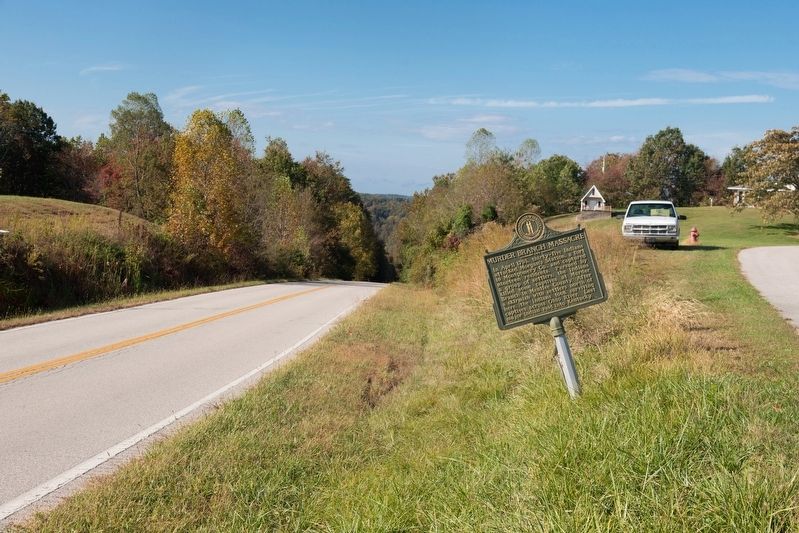
In April 1793, thirty-five Indians
attacked Morgan’s Station, a fort
in Montgomery County, and captured
nineteen residents. Pursued by
a group of settlers, the Indians
killed some captives at Murder
Branch in Menifee County. After
a skirmish . . . — — Map (db m146651) HM
These U.S. prisoners of war of the Japanese were on the island of Palawan, P.I. as slave laborers building an airfield for the Japanese military. Believing that an invasion by the U.S. forces was imminent, the prisoners were forced into three tunnel . . . — — Map (db m124984) HM WM
An early morning attack on a train of 12 wagons at this spot resulted in the death of 11 men and the capture of Mrs. Thomas Morton and 9 year old Danny Marble. The attack was by Indian “Dog Soldiers” of the Cheyenne Tribe led by Chief Bull Bear. . . . — — Map (db m294411) HM
The fate of the Nelson Buck survey party lies
sealed forever in the dust of this meandering
valley. Theirs was a hard life with a tragic ending.
Nelson Buck was commissioned in 1869 to
survey in southwest Nebraska while encamped
about 1 . . . — — Map (db m251285) HM
Confederate attack on U.S. troops, April 1864 led to killing of Black soldiers and civilians. Atrocity diminished the placement of Black troops in N.C. — — Map (db m276290) HM
In memory of
Henry and Barbara Dilbone
who were killed by the Indians
on their farm to the north
August 18th, 1813
Buried at this place — — Map (db m29840) HM
Following the American Revolution, the new Federal government, in need of operating funds, sold millions of acres of western lands to land companies. One such company, the Ohio Company of Associates, brought settlement to Marietta in 1788. Two years . . . — — Map (db m16713) HM
During the Battle of the Bulge on December 17, 1944, a German Spearhead of SS Sturmbannfuhrer Joachim Peiper's group approached Baugnez crossroads, two miles
southeast of Malmedy in Belgium. At the same time, an American convoy of about 30 vehicles . . . — — Map (db m303037) HM
Near here at Harwood, on Sept. 10, 1897, immigrant coal miners on strike began a march for higher wages and equal rights. Unarmed, they were fired upon at Lattimer by sheriff's deputies. Nineteen marchers--Polish, Slovak, and Lithuanian--were . . . — — Map (db m32151) HM
Here on September 10, 1897, nearly 400 immigrant coal miners on strike were met and fired upon by sheriff's deputies. Unarmed, they were marching from Harwood to Lattimer in support of higher wages and more equitable working conditions. Nineteen of . . . — — Map (db m44043) HM
October 16, 1755, a band of Indians ambushed and killed, wounded, or took captive some 26 settlers of this region. The attack was just west along Penns Creek, and first to follow Braddock's defeat. — — Map (db m43293) HM
On April 2, 1891, at the nearby Morewood Mines of the H.C. Frick Coke Company, sheriff's deputies killed seven strikers; two more died later. These were among some 16,000 workers striking for higher wages in the coke region. Thousands of mourners . . . — — Map (db m55591) HM
On February 8, 1968, after three nights of escalating
racial tension over efforts by S.C. State College
students and others to desegregate the All Star
Bowling Lanes, 3 students died and 27 others were
wounded on this campus. S.C. Highway . . . — — Map (db m25299) HM
Following Emancipation, Federal Union soldiers arrived in Millican, along with the Freedmen's Bureau, to assist in the transition to Reconstruction. At the same time, the Ku Klux Klan first appeared in Millican, parading through Black . . . — — Map (db m267494) HM
A famous tragedy of the 1830s. While able-bodied men were away fighting Indians, six or seven women, some young children, and four elderly men - most of them relatives – were at home of John Edens (2.4 mi. SW of here). Indians attacked, killing . . . — — Map (db m245625) HM
Porvenir was a community in remote northwest Presidio County on the Rio Grande. In the midst of military conflicts and raids across and along the international border and in the immediate area during the Mexican Revolution, the small farming and . . . — — Map (db m141382) HM
In 1920 area miners went on strike to gain recognition of UMWA. On May 19 of the same year, twelve Baldwin-Felts Agency guards came from Bluefield to evict the miners from company houses. As guards left town, they argued with town . . . — — Map (db m169678) HM
Anglo-European Coal Miners Near Rock Springs, Wyoming... killed 26 Chinese on Thursday afternoon, September 3, 1885, and torched their nearby settlement. More than 550 other Orientals fled into the hills. Two days later, Fort Fred Steele's . . . — — Map (db m89829) HM
In 1840 and 1842, Texas pioneers McBain Jamison and Jeremiah Muncey settled near this site. They were part of the post-Texas revolution wave of settlers. As with much of the West during that era, Texas was a wild and often savage place. While . . . — — Map (db m295818) HM
In early September, 1857, the train arrived in a valley known as Mountain Meadows in southwestern Utah. Beginning early on the morning of September 7, the emigrants' camp was attacked by a group of Mormon militiamen and some Paiute Indians whom the . . . — — Map (db m225250) HM
Reconstruction Era Lynchings in Union County
After the Civil War, Black Americans were emancipated after more than two centuries of chattel slavery. Formerly enslaved people purchased land, built churches and schools, and eligible Black men . . . — — Map (db m196452) HM
In this vicinity
on a bank of the Colorado
October 21, 1840
a Comanche Indian village
was completely destroyed and much
stolen property recovered
including 500 horses
128 Indians were killed
34 were captured
The expedition . . . — — Map (db m73318) HM
From 1769-1776 Boston was the flashpoint for events leading up to the American Revolution. On February 22, 1770, a crowd gathered around the house and shop of a Tory sympathizer and customs agent, Ebenezer Richardson. When they started pelting the . . . — — Map (db m18766) HM
2 miles S.E., along Battle Creek in Jan. 1780, settlers fleeing from Renfro's Station on Red River about 17 miles away, were caught by Indians and massacred. The sole survivor was a widow named Jones who made her way 4 days later into a Settlements . . . — — Map (db m123306) HM
Only 2 young boys survived the Indian attack on Alexander Ward's 20 member party, Oregon bound on August 20, 1854.
Military retaliation for the slaughter so enraged the Indians that Hudson's Bay Co. posts Fort Boise and Fort Hall had to . . . — — Map (db m22328) HM
Tradition is woven of fact and fiction. Two islands in the Lake of the Woods are named “Massacre,” one on the Canadian, one on the American side of the boundary. The Canadian island, the larger of the two, is heavily wooded. The American island . . . — — Map (db m207138) HM
This marks the spot where the first Indian massacre took place in this immediate locality August 20th 1862. For further information see Kandiyohi County history. This immemorial erected by P. Broberg being one of the remnants of the massacre. — — Map (db m199592) HM
Major John Lee and his entire family, with the exception of a son Robert, were massacred near here by an Indian war party of August 16, 1782. — — Map (db m70663) HM
Mountain Meadows Massacre
In early September 1857, about 140 people camped in this valley. Most of them were families from northwest Arkansas. Led by Captains John T. Baker and Alexander Fancher, they were headed to new opportunities in . . . — — Map (db m284152) HM
The Butler Massacre. On March 20, 1818, Capt. William Butler, Capt. James Saffold, William Gardener, Daniel Shaw and John Hinson left Fort Bibb to meet Col. Sam Dale. They were attacked near Pine Barren Creek by Savannah Jack and his . . . — — Map (db m83259) HM
On January 1, 1923 a massacre was carried out in a small, predominantly Black town of Rosewood in Central Florida. The massacre was instigated by the rumor that a white woman, Fanny Taylor, had been sexually assaulted by a black man in her home . . . — — Map (db m179269) HM
The History of Brownsville. The origins of Brownsville began as the 12-year period of Reconstruction was ending following the Civil War. The Reconstruction era was a period of legal, political, and social recreation, during which Black . . . — — Map (db m227410) HM
Here, on May 5, 1813, Colonel Dudley's troops spiked the British artillery besieging Fort Meigs; but, in the enthusiasm of victory they were led into an ambush where over 600 were lost. — — Map (db m18774) HM
Ambrose Ripley and his wife Rachel (Wood) brought their family to Texas in 1837, settling near here in what was then Red River County. They established their home near the Nacogdoches Road (Cherokee Trace) and a stream now known as Ripley Creek. . . . — — Map (db m293983) HM
Here sleep
the victims of the
"Webster Massacre"
of August 27, 1839. About thirty homeseekers headed by John Webster enroute to what is now Burnet County, were attacked by a band of Comanche Indians After attempting to flee under cover of . . . — — Map (db m290711) HM
In memory of those who were killed in the Mountain Meadows Massacre, in September of 1857. Dedicated in 2020.
Modern historical research has yielded information which was not readily available to those who designed the 1955 monument. . . . — — Map (db m225251) HM
In the closing phases of the First Seminole War (1817-1818), a U.S. supply boat was attacked by Creek Indians. The boat was ascending the Escambia River from Pensacola in Spanish West Florida, and was bound for Fort Crawford in the American Alabama . . . — — Map (db m242608) HM
In 1918, Poland regained her independence, after enduring three partitions and domination for 123 years by Russia, Prussia, and Austria. Barely 21 years later, on September 1, 1939 Nazi Germany invaded Poland from the west, triggering the Second . . . — — Map (db m183378) HM
Boston Massacre 1770
Many Bostonians resented the presence and abuses of such a large military force in their midst, hostility grew rapidly, and there were frequent brawls between workers and soldiers. On the night of March 5, 1770, Captain . . . — — Map (db m215503) HM
These reported incidents of Shoshone Indian attacks on emigrant wagon trains in this gap and surrounding area between 1851 and August 10, 1862, led to the naming of these rock outcrop as "Massacre Rocks."
The granite marker was dedicated by . . . — — Map (db m124160) HM
In 1853, Captain John W. Gunnison was selected to lead an expedition to find a trans-continental railroad route. He followed the Old Spanish Trail through Salina Canyon, over the mountains to Pahvant Valley, and upon reaching Fillmore, visited . . . — — Map (db m69536) HM
A War of 1812 military action occurred in September 1812 three miles west/southwest of here. While escorting supplies from Fort Knox near Vincennes to Fort Harrison at Terre Haute, Sergeant Nathan Fairbanks and approximately a dozen soldiers were . . . — — Map (db m21761) HM
Masacre de Lod
La Masacre de Lod representa el estallido de un nuevo tipo de terrorismo asesmo, marcada por un completa indefrencia hacia el ser humano, más allá de los confictos sociales, políticos, o religiosas, dando comienzo . . . — — Map (db m226099) HM
Here, on a Sunday morning in July, 1832, seven members of the Wildes Settlement were murdered by an Indian raiding party from the Okefenokee Swamp. Six of the victims were of the Wildes family, one was a 12-year-old girl of the Wilkinsons. Five . . . — — Map (db m53057) HM
Dedicated to the memory of those who lost their lives in a most horrible Indian massacre 1861. Three hundred immigrants west bound. Only five escaped. — — Map (db m119536) HM
Headquartered in Fort Scott, Union Major General James G. Blunt was the highly recognized commander of the District of the Frontier. In 1863, Blunt decided his force needed to be closer to the gathering Confederate forces in the South and headed out . . . — — Map (db m170743) HM
Three miles west. Reputedly scene of one of last massacres in Ky. McClures and Kennedy's lived on hills above Bullocks pen creek and the Bran family occupied cabin on creek at foot of hills. Around 1805, party of Indians burned the Bran home after . . . — — Map (db m82149) HM
In memory of American soldiers killed during the Revolutionary War in the “Baylor Massacre” on September 28, 1778. Lt. Col. George Baylor’s 3rd Regiment of Continental Dragoons took quarters for the night on several nearby farms. Tories betrayed . . . — — Map (db m7874) HM
October 25, 1782, a British vessel ran aground near Barnegat City and was captured by patriot militiamen under Capt. Andrew Steelman. That night, while sleeping on the beach, Steelman and his men were massacred by Tory raiders led by John Bacon. — — Map (db m34603) HM
In commemoration of the patriots massacred in the Hancock House March 21, 1778. Erected by the Patriotic Order Sons of America of Salem County July 2, 1932. — — Map (db m21592) HM
The Cherry Valley Massacre of 1778
was led by British Captain Walter Butler
and Mohawk Chief Joseph Brant
on this strategically important
frontier settlement. — — Map (db m33655) HM
Around the spring nearby, was perpetrated, on April 20, 1781, the massacre of 20 Indians by Col. Daniel Broadhead's army of 300. This slaying was committed following destruction, the same day, of the two villages, Goschachgunk, (Coshocton) and . . . — — Map (db m14707) HM
Massacre Farm North To E. Whiteland Included A Site. Southwest of This Marker. The 19th Century House and Springhouse, Headwater of Crum Creek. Were torn down in 1989 — — Map (db m48226) HM
The Hamburg Massacre, which occurred nearby on July 8, 1876, was one of the most
notable incidents of racial and political violence in S.C. during Reconstruction. White Democrats across the state organized “rifle clubs” to intimidate black and . . . — — Map (db m238696) HM
This monument erected by surviving relatives and other Ogallala and Cheyenne River Sioux Indians in memory of the Chief Big Foot Massacre December 29, 1890. Col. Forsyth was in command of the U.S. Troops. Big Foot was a great chief of the Sioux . . . — — Map (db m122747) WM
This monument replaces one previously erected (that crumbled through weather conditions) by Langley A. Bailey, Sr., Jacob Bowers and Henry Knowles in memory of the following pioneers: Jens Jergensen and wife, Jens Terkelsen and Christian E. Kjerulf . . . — — Map (db m75247) HM
Near this spot on Tuesday, October 17, 1865, Black Hawk, a Ute chief, led his warriors out of Cottonwood Canyon foraging for cattle. They stole the entire Ephraim herd. Settlers who were working in the fields were massacred and lie buried in one . . . — — Map (db m74951) HM
In early September 1857, about 140 people camped in this valley. Most of them were families from northwest Arkansas. Led by Captains John T. Baker and Alexander Fancher, they were headed to new opportunities in California. Their worldly possessions . . . — — Map (db m284151) HM
Built and maintained by The Church of Jesus Christ of Latter-day Saints out of respect for those who died and were buried here and in the surrounding area following the massacre of 1857. — — Map (db m152387) HM
In early September 1857, about 140 people camped in this valley. Most of them were families from northwest Arkansas. Led by Captains John T. Baker and Alexander Fancher, they were headed to new opportunities in California. Their worldly possessions . . . — — Map (db m284149) HM
Erected by the State of Minnesota
in the year 1909, to the memory of the pioneer setters of Jackson County, whose names are inscribed below, massacred by the Sioux Indians on March 26th, 1857, and August 24th, 1862.
1857 Massacre
William . . . — — Map (db m205190) HM
In the 1830's, local tribes, including the Shoshone, Paiute, and Bannock began trading with Euro-American fur trappers and missionaries passing through southern Idaho. Peaceful exchanges beneficial to both groups increased in 1842 when wagon . . . — — Map (db m22333) HM
Sicilian Immigration to Louisiana. From the 1870s till 1920, approximately 3,000
Sicilians per year immigrated to America via New Orleans. They worked on plantations, railroads, and docks; soon becoming entrepreneurs in importing. shipping. . . . — — Map (db m277491) HM
Cherry Valley
Sacred to the memory
of those who died by
Massacre
in the destruction of this village
at the hands of the Indians & Tories
under Brant & Butler,
Nov. 11. AD. 1778
— — Map (db m154638) HM WM
Bevier Family
Widow Elizabeth Bevier Age 62
Her Sons
Solomon Age 29 • Josiah Age 23
——————
Sax Family
Widow Johannah Sax Age 59 . . . — — Map (db m118476) HM
Gnadenhutten
The Moravian Church in America began missionary work among the Delaware and Mohican tribes of North America in the mid-18th century. David Zeisberger, one of the best-known Moravian missionaries, came to the Ohio country with . . . — — Map (db m224977) HM
Primer marcador: Guatemalteco: Aquí sacrifico su juventud el Br. Cesar Armando Funes, la tarde del 12 de abril de 1962, en defensa de la libertad y la democracia. Guatemala, Sept. de 1962 Segundo marcador: Cesar Armando . . . — — Map (db m98013) HM WM
1968-1993
…Adelante!!
A los compañeros caídos
el 2 de octubre de 1968 en esta plaza
Cuitlahuac Gallegos Bañuelos, 19 años. Ana María Maximiana Mendoza, 19 años. Gilberto Reynoso Ortíz, 21 años. Antonio Solorzano Gaona, 47 años. . . . — — Map (db m91671) HM
In memory of the estimated 400 men, women, and children of the Northwestern Shoshone Nation who were brutally massacred in this vicinity on January 29, 1863, by the United States Army California Volunteers from Fort Douglas, Utah, under the . . . — — Map (db m277311) HM
Fort Jefferson Site Built in 1780 by George Rogers Clark as part of impressive plan of settlement, conceived by Gov. Patrick Henry of Virginia, later pursued by and named for Gov. Thomas Jefferson. The fort was to protect US claim to its . . . — — Map (db m18639) HM
The Palmyra Massacre
The Palmyra Massacre was a grim ending to Confederate Col. Joseph Porter's 1862 recruiting campaign in northeast Missouri. Besides recruiting local men for the Confederate army, Porter attacked Union outposts and patrols . . . — — Map (db m55390) HM
The Massacre was part of a concerted attack by the Sioux, Cheyenne and Arapaho Indians that ranged from Julesburg, Colorado to the valley of the Little Blue River in Nebraska. Ranches, stage stations, homesteaders' cabins and wagon trains were . . . — — Map (db m294412) HM
Giovanni Pedroni Marcellus Locatelli Teodoro Zesta Pompeo Pattini Antonio Canonica
Charcoal Burners Massacred Aug. 18, 1879 By A Sheriff's Posse Southwest Of The Fish Creek Ranch — — Map (db m89510) HM
On November 4, 1791 on this triangle of land between the rivers, Indian forces under Chief Little Turtle (Miamis) and Blue Jacket (Shawnees), surrounded General Arthur St. Clair's troops. Of his 1,200 soldiers, 900 were killed. It was the worst . . . — — Map (db m256972) HM
At this site one Sunday night in November 1836, the family of John Harvey was attacked by an Indian raiding party. Harvey, his wife, and son were all killed, Mrs. Harvey's blood staining the open pages of the family Bible. Their daughter Ann, aged . . . — — Map (db m164650) HM
In the spring of 1865 John Given with his wife Eliza and their four children, John Jr., Mary, Anna, and Martha, settled in the meadow land about 110 feet west of here. They built a cabin and willow shanty. Charles Brown and Charles W. Leah were . . . — — Map (db m139785) HM
In memory of
Col. Archibald Lochry
and the members of the Westmoreland County, Pennsylvania
Militia, who were defeated near here August 24, 1781
by Chief Joseph Brant and a coalition of Ohio Indians.
Killed
Col. Archibald Lochry . . . — — Map (db m222279) WM
Ku Klux Klan members and American Nazis, on Nov. 3. 1979, shot and killed five Communist Workers Party members one-tenth mile north. — — Map (db m219790) HM
In this defile on August 10, 1862 a band of Shoshone Indians ambushed an Immigrant Train bound for Oregon killing nine white men and wounding six. — — Map (db m124159) HM
By October 1860 the Van Ornum party reached Farewell Bend. They were survivors of the Elijah P. Utter wagon train that was attacked by Indians on September 9 and 10, just west of Castle Butte in Owyhee County, Idaho. The survivors had escaped the . . . — — Map (db m107292) HM
The Story of the Waxhaws Immediately after the engagement, reports spread that many were stabbed and killed as they tried to surrender. Many were taken to a local Presbyterian church where local residents cared for them, including a young Andrew . . . — — Map (db m95555) HM
Homenaje de la Comunidad Universitaria a los Martires Caidos en la Masacre del 30 de Julio de 1975 Carlos Fonseca ∙ Carlos Humberto Hernández ∙
Roberto Antonio Miranda ∙ Eber Gómez Mendoza ∙ Balmore Cortez . . . — — Map (db m142522) HM WM
The Spaniard[s]committed a horrible execution... each trying to outdo the other in slaying... I would not find greater cruelty among wild beasts.
Nicolas le Challeux, la Caroline carpenter
At the break of dawn on . . . — — Map (db m310970) HM
In one of the most violent episodes in Reconstruction Georgia, a rally in Mitchell County in September 1868 resulted in about a dozen freedmen being killed and several dozen wounded. Georgia had been re-admitted to the United States just two . . . — — Map (db m218685) HM
Erected to the memory of the
Otter Massacre
1860
Forty four persons ambushed by Shoshoni Indians either killed or scattered. Most awful human experience. Site ten miles east on Sinker Creek. — — Map (db m110210) HM
In memory of the pioneer heroes, Twenty-Two in number, massacred at Pigeon Roost defeat by the Shawnee Indians, Sept. 3, 1812
The Sixty-Third General Assembly of Indiana appropriated Two-Thousand dollars for the erection of this monument. . . . — — Map (db m245539) HM WM
Olson Slaabakken Cabin
Emmet Olson donated this cabin to the city of Jackson in 1926. The cabin is said to have been the first cabin occupied by the family of Engebret Olson when they arrived in Jackson County in 1860. He said that he traded a . . . — — Map (db m205193) HM
“This millstone is the only visible marker of the Baylor Massacre in existence today. On September 28, 1778, a detail of Baylor’s Continental Dragoons camping at Haring’s Tannery in River Vale was betrayed into the hands of the British by a Tory . . . — — Map (db m7876) HM
On this site, Col. Abraham Buford's force of about 350 American patriots, while returning to Hillsborough, N.C., following the fall of Charles Town, were overtaken by British troops commanded by Col. Banastre Tarelton, it is historically told that . . . — — Map (db m23890) HM
On May 1, 2 and 3, 1866, mobs of white men
led by law enforcement attacked black people
in the areas near South St. (aka Calhoun & G.E.
Patterson). By the end of the attack, the mobs
had killed an estimated 46 black people; raped
several . . . — — Map (db m117114) HM
After the fall of the Alamo, March 6, 1836, Colonel James Walker Fannin, with about 400 soldiers, mostly volunteers from the United States in the Texas War for Independence, was ordered by Texas General Sam Houston to retreat from Goliad to . . . — — Map (db m116301) HM
The Massacre of Kerr's Creek took place near the Big Spring a few hundred yards from this spot.
Oct. 10, 1764
A band of Shawnee Indians coming over the mountains from the Ohio surprised the fort and killed from fifty to sixty persons. This was . . . — — Map (db m107985) HM
Scene of massacre, 1792, of daughters of Henry Morris,
early settler and son of first permanent settler
in Great Kanawha Valley. Graves of Henry Morris
and the Indian victims may be seen from the road. — — Map (db m165010) HM
1449 entries matched your criteria. Entries 101 through 200 are listed above. ⊲ Previous 100 — Next 100 ⊳
Thin black lines indicate changes in relevance. Between each pair of lines entries are ordered geographically but all have the same relevance.
* Inflectional forms of words are their plurals, singulars, and possessives as well as gramatical tenses and similar variations.