By Barry Swackhamer, May 3, 2018
The Powerful Payette panel
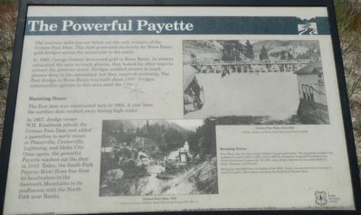
| On Banks Lowman Road (County Highway 17) near Annie Lane, on the left when traveling west. |
| On State Highway 21 at milepost 95,, 1.4 miles north of Grandjean Road, on the right when traveling north. |
| On State Highway 55 at milepost 64, just south of West Boise Street, on the left when traveling south. |
| On Montgomery Street near Wall Street, on the left when traveling north. |
| On Wall Street at Main Street, on the right when traveling east on Wall Street. |
| On Main Street at East Walulla Street, on the right when traveling north on Main Street. |
| Near Main Street at East Walulla Street, on the right when traveling north. |
| On State Highway 21 at milepost 28 at Grimes Creek Road, on the left when traveling north on State Highway 21. |
| On East Walulla Steet near High Street, on the left when traveling north. |
| On State Highway 21 at milepost 38,, 0.1 miles west of Lodgepole Lane, on the left when traveling north. |
| On Wall Street at Commercial Street, on the right when traveling west on Wall Street. |
| On Wall Street at Commercial Street, on the right when traveling west on Wall Street. |
| On Wall Street near Commercial Street, on the right when traveling west. |
| On Main Street near Wall Street, on the right when traveling north. |
| On Montgomery Street near Wall Street, on the left when traveling north. |
| Near East Walulla Steet near High Street, on the left when traveling north. |
| On East Walulla Steet at High Street, on the left when traveling west on East Walulla Steet. |
| On Montgomery Street at Commercial Street, on the right when traveling north on Montgomery Street. |
| On Main Street at Commercial Street, on the right when traveling north on Main Street. |
| On State Highway 21 at milepost 20,, 0.2 miles south of Stewart Way, on the left when traveling north. |
| On Main Street at Wall Street, on the left when traveling north on Main Street. |
| On Main Street at Wall Street, on the left when traveling north on Main Street. |
| On Ponderosa Pine Scenic Route (State Highway 21) at County Highway 558, on the right when traveling east on Ponderosa Pine Scenic Route. |
| On Banks Lowman Road (State Highway 17) near Forest Road 555, on the left when traveling west. |
| On State Highway 21 at milepost 77,, 0.6 miles east of Kirkham Road, on the right when traveling east. |
| On Ponderosa Pines Scenic Byway (State Highway 21) near Forest Road 364, on the left when traveling north. |
| On Ponderosa Pine Scenic Route (State Highway 21), on the right when traveling east on Ponderosa Pine Scenic Route. |
| On State Highway 21 at milepost 72,, 0.2 miles east of Banks Lowman Road, on the right when traveling north. |
| On Granite Street at Standifer Road, on the right when traveling east on Granite Street. |
| Near Granite Street (County Highway 343) near Mespile Road. |
| On Standifer Road at Granite Street, on the right when traveling north on Standifer Road. |
| On Wellington Place, 0.1 miles north of School Street, on the right when traveling south. |
| On State Highway 200, on the right when traveling south. |
| On State Highway 200, on the right when traveling south. |
| On Wellington Place, 0.1 miles north of School Street, on the right when traveling south. |
| On Hope Peninsula Road at 200, on the right when traveling south on Hope Peninsula Road. |
| On State Highway 200, on the right when traveling south. |
| Near U.S. 2, 3 miles east of Le Clerc Road, on the right when traveling east. |
| Near U.S. 2 at Le Clerc Road, on the right when traveling east. |
| On North Fifth Avenue (U.S. 2) near Larch Street, on the right when traveling north. |
| On Central Avenue at Molen Street, on the right when traveling south on Central Avenue. |
| On South 1st East at West 127th South, on the right when traveling south on South 1st East. |
| Near West Broadway Street near River Parkway, on the left when traveling west. |
| On Riverside Drive at Memorial Drive, on the right when traveling south on Riverside Drive. |
| On West Arco Highway (U.S. 20 at milepost 291) near North 135 West, on the left when traveling west. |
| On River Parkway, 0.5 miles north of West Broadway Street, on the right when traveling north. |
| On East 97th South near South 15th East, on the right when traveling west. |
| On Idaho Falls Greenbelt Trail, 0.5 miles north of West Broadway Street, on the right when traveling north. |
| On Idaho Falls Greenbelt Trail, 0.1 miles north of Memorial Drive, on the left when traveling north. |
| On Idaho Falls Greenbelt Trail, 0.2 miles north of West Broadway Street, on the right when traveling north. |
| On River Parkway, on the right when traveling north. |
| On Riverside Drive at Memorial Drive, on the right when traveling south on Riverside Drive. |
| On Memorial Drive at Riverside Drive, on the left when traveling north on Memorial Drive. |
| On North Main Street/Old U.S. 30 at Rockwood Avenue on North Main Street/Old U.S. 30. |
| On North 105 East near U.S. 26. |
| Near North 5th East (Lewisville Highway) near East 113 North, on the right when traveling south. |
| Near Main Street near Riverside Street, on the right when traveling north. |
| On Chinook Street at U.S. 95, on the right when traveling east on Chinook Street. |
| On Main Street near U.S. 95, on the left when traveling west. |
| On U.S. 95 at milepost 504 near Deep Creek Loop (State Highway 2), on the left when traveling north. |
| On Riverside Drive near Main Street, on the right when traveling west. |
| On U.S. 95 at milepost 504 near Deep Creek Loop (State Highway 2), on the left when traveling north. |
| On Main Street near Riverside Street, on the right when traveling north. |
| On Chinook Street at U.S. 95, on the right when traveling east on Chinook Street. |
| On Main Street near Riverside Street. |
| Near Main Street near Riverside Street, on the right when traveling north. |
| On U.S. 2, 0.4 miles south of Old US Highway 2, on the right when traveling south. |
| On Riverside Street (U.S. 2) at Riverside Street, on the left when traveling east on Riverside Street. |
| Near Main Street near Riverside Street, on the right when traveling north. |
| Near Main Street near Riverside Street, on the right when traveling north. |
| On Main Street near Riverside Street. |
| On Riverside Drive near Main Street. |
| Near Main Street near Riverside Street, on the right when traveling north. |
| On U.S. 95 at milepost 504 near Deep Creek Loop (State Highway 2), on the left when traveling north. |
| Near U.S. 20 at milepost 265,, 1.2 miles west of Van Buren Boulevard, on the right when traveling east. |
| On N. Front Street (U.S. 26) at HWY Drive, on the right when traveling west on N. Front Street. |
| On W. Grand Ave south of S. Bingham Street, on the right when traveling north. |
| On U.S. 26/93 near North Laidlaw Park Road, on the right when traveling east. |
| Near U.S. 26, 1 mile west of Van Buren Blvd, on the right when traveling south. |
| On Loop Road near the Park Entrance. |
| On U.S. 26/93 near North Laidlaw Park Road, on the right when traveling east. |
| On S. Front Street (U.S. 26) at HWY Drive, on the right when traveling west on S. Front Street. |
| On U.S. 20, 1.5 miles west of Craters Loop Road, on the right when traveling east. |
| Near U.S. 20 at milepost 265,, 1.2 miles west of Van Buren Boulevard, on the right when traveling east. |
| On S. Front Street (U.S. 26) at HWY Drive, on the right when traveling west on S. Front Street. |
| Near U.S. 20 at milepost 265,, 1.2 miles west of Van Buren Boulevard, on the right when traveling east. |
| On U.S. 20/26 west of Portland Avenue, on the left when traveling west. |
| On U.S. 26/93 near North Laidlaw Park Road, on the right when traveling west. |
| On U.S. 26/93 near North Laidlaw Park Road. |
| On S. Front Street (U.S. 26) near HWY Drive, on the right when traveling west. |
| On S. Front Street (U.S. 26) at HWY Drive, on the right when traveling west on S. Front Street. |
1101 entries matched your criteria. Entries 201 through 300 are listed above.
⊲ Previous 100 —
Next 100 ⊳