Greendale was one of three Greenbelt towns constructed by the Federal Government during the 1930s. The main objectives were to demonstrate a planning concept combining the best of country and city living, to provide good housing for low income . . . — — Map (db m33210) HM
Side A In 1836, surveyors working for the U.S. General Land Office measured out the 6x6 mile grid of the future Town of Greenfield. Arterial roads and streets were later built at half-mile intervals following that pattern. In the days before . . . — — Map (db m35083) HM
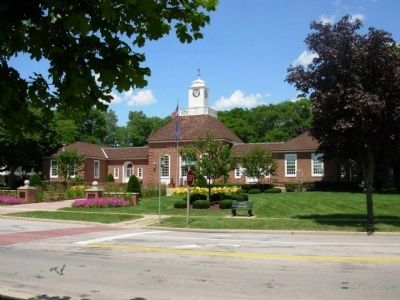
Following the end of World War II, Milwaukee’s rapid urban development forced the seven rural towns of Milwaukee County into annexation or incorporation. When Greenfield incorporated as a city in 1957, the last of Milwaukee County’s towns . . . — — Map (db m34761) HM
The Root River system began forming about 20,000 years ago when Wisconsin’s glaciers began to retreat. Starting in eastern New Berlin, it flows through southwest Milwaukee County before entering Lake Michigan at the city of Racine (French for . . . — — Map (db m81350) HM
Side A:
The Janesville Plank Road was one of 16 privately-owned toll roads authorized by Wisconsin’s Territorial legislature in 1848. The road was specified to follow a 65 mile route from Milwaukee through East Troy to Janesville. Its . . . — — Map (db m33355) HM
The Land Survey of 1836
In 1836 US Government land surveyors measured an approximately six-mile square area described as Township 6 North, Range 21 East and divided it into a nearly-uniform grid of 36 one-mile square sections. By 1841 this area . . . — — Map (db m136420) HM
Of German birth, Pabst became a ship's captain in the 1850s and moved to Milwaukee in the 1860s. He later joined his father-in-law's brewery (founded 1844), which was renamed the Pabst Brewery in 1889. By the 1890s it was the world's largest lager . . . — — Map (db m8306) HM
Mabel Raimey was the first African-American woman attorney in Wisconsin and the first to graduate from the University of Wisconsin-Madison (1918). She attended Marquette University Law School and was admitted to the Wisconsin Bar in 1927. An . . . — — Map (db m95799) HM
From a quiet mid 19th–century farming community to a bustling industrial center along Kinninckinnic Avenue in only twenty years, Bay View’s industrial transformation could not have occurred without the contributions of hundreds of immigrant . . . — — Map (db m34803) HM
Near this site in Bay View stood the Milwaukee Iron Company rolling mill, the first major heavy industry in the region and an important producer of iron and steel for the Midwest. The mill, which opened in 1868, transformed ore from Dodge County and . . . — — Map (db m75452) HM
On October 29, 1926, Milwaukee County purchased the flying field which Thomas Hamilton had established in 1920 on East Layton Avenue in connection with his propeller business. Northwest Airways inaugurated scheduled passenger service here on July 5, . . . — — Map (db m38870) HM
Carl Sandburg (1878-1967), poet, balladeer, biographer of Lincoln, soldier in the Spanish-American War, came from Illinois to Wisconsin in December 1907 as a state organizer for the Social-Democratic party in eastern Wisconsin. After marrying . . . — — Map (db m32619) HM
The UWM Library is named for Golda Meir. Born Goldie Mabowehz in the Ukraine, she migrated to Milwaukee in 1906, was educated at Fourth Street School, North Division High School, and in present Mitchell Hall of Milwaukee Normal School (1916-17). She . . . — — Map (db m32664) HM
On September 14, 1848, Mrs. William L. Parsons, the wife of a Congregational minister, opened the Milwaukee Female Seminary at the corner of Milwaukee and East Wells. Three years later it was chartered by the Legislature, thus placing Wisconsin in . . . — — Map (db m32667) HM
Milwaukee’s State Normal School, which was founded in 1885 on the city’s west side to train teachers, relocated in 1909 to this building, Mitchell Hall, then located on 11–1/2 acres. Designed by Van Ryn and de Gelleke, expanded in 1912, and named . . . — — Map (db m32666) HM
Near here, at the foot of Huron (now Clybourn) Street, the first cargo pier in Milwaukee harbor was built by Horatio Stevens, Richard Owens, Amos Tufts and J.G. Kendall during the winter of 1842-43. The first vessel to dock at North Pier was the . . . — — Map (db m31137) HM
In this station pulverized coal was first successfully burned continuously and at high efficiencies in furnaces of stationary steam boilers November 11-15, 1919. This radical departure from conventional firing methods of the period was vigorously . . . — — Map (db m80527) HM
Designed by Otto Strack and built by Milwaukee brewing magnate Captain Frederick Pabst, the Pabst Theater was constructed on the site of an earlier opera house destroyed by fire in 1895. The Pabst was completed in just six months and opened on . . . — — Map (db m32367) HM
Joshua Glover was a runaway slave who sought freedom in Racine in 1852. In 1854, his Missouri owner used the Fugitive Slave Act to apprehend him. This 1850 law permitted slave catchers to cross state lines to captured escaped slaves. Glover was . . . — — Map (db m33013) HM
The Milwaukee Sentinel has chronicled the events of Milwaukee, Wisconsin, and the world longer than any other newspaper in the state. Founded as a weekly on June 27, 1837 by Solomon Juneau, Milwaukee’s first mayor, the Sentinel was first published . . . — — Map (db m32369) HM
The loss of the sidewheel steamship Lady Elgin was one of Lake Michigan’s most tragic maritime disasters. On September 8th, 1860, the ship, returning to Milwaukee from Chicago, sank following a collision nine miles off Winnetka, Illinois. . . . — — Map (db m37263) HM
On the evening of October 28, 1892, an exploding oil barrel started a small fire in the Union Oil and Paint company warehouse, which was located at 323 N. Water Street. Another fire broke out in a nearby factory in the 300 block of N. Broadway, . . . — — Map (db m105780) HM
The 1871 Wisconsin legislature authorized the City of Milwaukee to finance and build a public water system. By 1873 the Board of Water Commissioners had constructed the old North Point Pumping Station below the bluff with intake from Lake Michigan, . . . — — Map (db m34765) HM
Founded May 15, 1848, with the Daughters of Charity of St. Vincent de Paul providing direction and nursing, St. John’s Infirmary offered Wisconsin’s first public hospital care under the supervision of the patient’s physician. (Prior institutions . . . — — Map (db m37314) HM
Formal nurses training in the United States began in Boston in 1872. In 1888, the Women's Club of Wisconsin organized the Wisconsin Training School for Nurses patterned after the Bellevue School of Nursing in New York.
In 1894, the Daughters of . . . — — Map (db m96213) HM
On Christmas Day 1847, a group of German-speaking settlers, mostly from Pennsylvania, met and founded the German Evangelical Lutheran and Reformed Church of Granville Township. By June 1849, these settlers had built and dedicated a log church on a . . . — — Map (db m68205) HM
In 1879, Sherburn S. Merrill, the General Manager of the Chicago, Milwaukee and St. Paul Railroad, purchased almost half a square mile in the Menomonee Valley to construct a massive railroad shop complex. By the early 1880s, the railroad company . . . — — Map (db m34802) HM
Started in 1848 and completed in 1853, extended 58 miles west from Milwaukee on a course roughly paralleling State Street past the Frederick Miller Plank Road Brewery through Wauwatosa, Pewaukee, and Oconomowoc to Watertown. The $110,000 road of . . . — — Map (db m31123) HM
Near here a Civil War training camp was built in August 1861. Named Camp Holton, Camp Sigel and finally Camp Reno, its boundaries were Prospect and Bartlett Avenues and Lafayette and Royall Places. Six Wisconsin infantry regiments, almost 7,000 men, . . . — — Map (db m37272) HM
The North Point Light Station has a long history of guiding mariners to Milwaukee. Its location was chosen to mark the north point of Milwaukee Bay. Erected in 1887 and first lit in 1888, the 39-foot octagonal cast-iron tower replaced an 1855 . . . — — Map (db m48408) HM
Milwaukee’s first lighthouse was erected in 1837 on a 56 foot bluff at the east end of Wisconsin Ave. It was replaced in 1855 by a 28 foot tower 100 feet east of the present location. Erosion forced the rebuilding in the 1870’s and relocation . . . — — Map (db m34766) HM
Dr. Erastus B. Wolcott was an originator of the idea for a national soldier’s home in Milwaukee.
A spirited leader in medicine, business and government, he was state surgeon-general during the Civil War and an ardent advocate for what is now the . . . — — Map (db m77415) HM
The Wisconsin Soldiers’ Home Association was formed in 1864 by a coalition of women’s charitable organizations led by Lydia Hewitt, Hannah Vedder, and Mrs. E. L. Buttrick of Milwaukee. The Association raised funds to endow a hospital where sick and . . . — — Map (db m95766) HM
Milwaukee is known as “The Cream City” not because of dairies or breweries, but because of its historic pale yellow brick buildings constructed throughout the 19th century. These buildings are a distinctive “cream” color because they are made from . . . — — Map (db m32741) HM
Milwaukee born and educated, lawyer Carl F. Zeidler became Milwaukee’s 33rd mayor in April, 1940, when he defeated Daniel W. Hoan, Socialist mayor since 1916. In April, 1942, Zeidler left office to enter service as a U.S. Navy Lieutenant (j.g.). On . . . — — Map (db m37268) HM
St. Mark African Methodist Episcopal Church, the first African-American church built in Wisconsin, once stood on this site. The property was purchased in 1869, the year the congregation was organized. Construction on the St. Mark A.M.E. church . . . — — Map (db m35201) HM
At 318 State Street, approximately 300 feet northeast of here, C. Latham Sholes perfected the first practical typewriter in September, 1869. Here he worked during the summer with Carlos Glidden, Samuel W. Soule, & Matthias Schwalbach in the machine . . . — — Map (db m31124) HM
In this vicinity, Kilbourntown, one of three original Milwaukee settlements, was founded by surveyor and land speculator Byron Kilbourn in 1835. Kilbourntown’s first residents were entrepreneurs from the East. In 1839, a small group of German . . . — — Map (db m37262) HM
MacArthur Square was designated on September 17, 1945 to honor General of the Army Douglas MacArthur for his leadership of Allied forces in the Pacific during World War II. MacArthur, his father General Arthur MacArthur, and his grandfather Judge . . . — — Map (db m219037) HM
The Milwaukee Electric Railway and Light Company opened its terminal here in 1905. The first car entered this building January 1, 1905.
The first floor was the terminal area, with two waiting rooms and thirteen car tracks; it was then the . . . — — Map (db m80529) HM
In April 1864, women of the former West Side Soldiers’ Aid Society opened a temporary Civil War Soldiers’ Home at this location. By May 1867, the home’s Lady Managers had welcomed 21,550 Union soldiers, given medical care to over 1,000, and provided . . . — — Map (db m77417) HM
This park played a key role in Shorewood’s development. In 1872, Frederick A. Lueddemann opened Lueddemann’s-On-The-River on this site in the Town of Milwaukee. Otto Zwietusch bought the resort in 1876 and renamed it Mineral Springs Park. . . . — — Map (db m30250) HM
The Shorewood Armory, once located near Capitol Drive and Oakland Avenue, was home to the cavalry unit of the Wisconsin National Guard from 1910 to 1930. Originally called the Light Horse Squadron, the cavalry drilled their horses on the thirty-acre . . . — — Map (db m167061) HM
A forerunner in secondary school design, Shorewood High School is modeled on a university campus plan. Constructed between 1924 and 1938 by Milwaukee architects Herbst and Kuenzli, the school includes separate buildings for administration, physical . . . — — Map (db m30248) HM
Shorewood Village Hall was built in 1908 as a four-room school to serve Shorewood, then called East Milwaukee. In 1915 this building became the seat of village government. The building was extensively remodeled in 1937 with Works Progress . . . — — Map (db m30249) HM
From 1919 to 1922, this property housed the Lawson Airplane Company, founded by pioneer aviator Alfred W. Lawson. The company produced the first two commercial passenger airplanes in the U.S. Lawson dubbed these “airliners.” Many features standard . . . — — Map (db m210455) HM
Lake Protestant Cemetery was founded as a farm cemetery in the 1840s on Jared Thompson’s land and was incorporated in 1855. This three-quarter acre cemetery is divided into forty-two lots. The earliest burial dates to 1846, and the most recent . . . — — Map (db m155525) HM
In 1920, the Lakeside Power Plant opened here, becoming the world’s largest plant to exclusively burn pulverized coal. The lighted smokestacks were visible to ship captains and airplane pilots for miles off shore until 1987 when the plant was razed. — — Map (db m185575) HM
One of the earliest publicly–owned airports in the United State was established here on July 3, 1919, by the Milwaukee County Park Commission.
The nation’s first commercial air transport, the Lawson Airliner, took off from this field on August . . . — — Map (db m236877) HM
Patriot James Morgan was born April 5, 1748, in Frederick County, Virginia. At the age of 30, Morgan enlisted in the Revolution for a three-month tour in Colonel John Evan’s Virginia Regiment. He served with General McIntosh’s campaign in the Ohio . . . — — Map (db m31763) HM
At the outbreak of the Spanish-American War in April of 1898, President William McKinley called on the states to gather their military forces. State officials ordered the Wisconsin National Guard to report for duty at Camp Harvey, named for . . . — — Map (db m36393) HM
This tract of land was once a part of the estate on which General William (Billy) Mitchell (1879-1936) lived as a boy. His fearless and inquisitive personality as a youth carried over into his military career when he spoke out against overwhelming . . . — — Map (db m31135) HM
Ho-Chunk histories indicate that this area has long been an important gathering place known as Tee Sisikeja (Bad Waters Village). Here, ancestors of the Ho-Chunk constructed burial sites for loved ones in the form of mounds, a practice that dates . . . — — Map (db m208429) HM
In 1892, this site became the permanent home of the Wisconsin State Fair after its purchase a year earlier by the State Agricultural Society. Until then, the Fair had moved annually since the first one in Janesville in 1851.
Over the years, . . . — — Map (db m8311) HM
This is Mill Bluff, one of many isolated and rocky castle-like hills which rise abruptly from the surrounding plain. This formation is properly called a mesa (Spanish for "table") if large and butte if small.
Mesas and buttes in this driftless . . . — — Map (db m31736) HM
This 32 mile state trail was formerly the mainline of the Chicago and North Western Railway. The conversion from “rail to trail” represented a new concept in recreational development. Utilizing the abandoned railbed, it was the first . . . — — Map (db m18710) HM
Astronaut Deke Slayton was born in Sparta on March 1, 1924. His parents, Victoria and Charles Slayton, lived on a farm in the town of Leon. As a young boy, he attended Leon School in this building, which now serves as the Leon Community Center.
. . . — — Map (db m43574) HM
Several times during the ice ages, glaciers flowed out of Canada, sometimes reaching as far south as the Ohio and Missouri rivers. During recent glaciations, southwestern Wisconsin was untouched, because the glaciers were diverted to the east or . . . — — Map (db m174938) HM
From the hills all around, rugged valleys collect for rivers that feed the mighty Mississippi. The early French called such a valley a coulee. These many valleys, large and small, still are known as coulees, a regional name for a regional landscape. . . . — — Map (db m8921) HM
The Masons constructed this building in 1923, as Sparta's first building devoted entirely to a social organization. The architecture is characterized by an eclectic mix of Classical Revival and Prairie School influences. Noted regional architect and . . . — — Map (db m9037) HM
Monroe County was created in 1854, and Sparta became the county seat. The present building is the third Monroe County courthouse and replaced an 1863 courthouse. It was constructed in 1895 at a cost in excess of $50,000. Chicago architect Mifflin E. . . . — — Map (db m8960) HM
Prior to the construction of this building in 1902, the Sparta Free Library had several homes in the community. Schick and Roth, a LaCrosse architectural firm, designed the library building.
Steel magnate Andrew Carnegie provided construction . . . — — Map (db m9054) HM
Prior to the construction of this building in 1915, Sparta's post office was housed in a variety of buildings such as the nearby Masonic Temple. Although the initial federal appropriation for the post office was secured by Congressman John Esch . . . — — Map (db m9003) HM
When this site was selected for a settlement in 1855, one of its founders read in an old history of the state that the Menominee Chief Tomah had at one time gathered his tribe in this vicinity for a conference.
He suggested the name "Tomah" for . . . — — Map (db m3960) HM
Generally called "Depot Camp," it is the oldest standing lumber camp in Wisconsin. It remains where originally built in 1880, in what was one of the greatest white pine regions of the middle west. Expert woodsmen built the camp as is evidenced by . . . — — Map (db m36898) HM
The Couillardville area covers approximately one and one half miles along the Lower Oconto River Valley. The area is filled with archeological sites extending from Paleo-Indian through the Historic Indian occupations. South of this site on the north . . . — — Map (db m139711) HM
This library, by architect Henry Foeller, was completed in 1903. Oconto lumberman George Farnsworth gifted $15,000 for the building and gave the dedicatory address. The library is a beautiful example of the Neoclassical Revival style and is a vital . . . — — Map (db m139713) HM
This church was organized June 10, 1886. The first service was held here October 31 of the same year. Seven years earlier Mary Baker Eddy, the Discoverer and Founder of Christian Science, had founded the Church of Christ, Scientist, in Boston, . . . — — Map (db m13164) HM
On December 2, 1669, the Eve of St. Francis, Father Claude Allouez arrived at Oconto, then a village of about 600 Indians. Here Allouez founded the Mission of St. Francois Xavier, the first mission in north eastern Wisconsin. Six French fur traders . . . — — Map (db m13440) HM
At this site approximately 4,500 years ago, Wisconsin Indians gathered to bury their dead. Because of their use of copper tools, weapons and ornaments, this group became known as the Old Copper people. They fashioned spearpoints, knives and . . . — — Map (db m58143) HM
This building is all that remains of the once-larger Stanley Toy Company building. Established by Chester Schwedler in 1946, the Stanley Toy Company made cast-metal horse-drawn carriages and bunny toy carts. On December 29, 1949, fire destroyed the . . . — — Map (db m58140) HM
The Mecikalski Stovewood General Store is named for John Mecikalski, who emigrated from Prussia with his parents in the 1870s. John married and purchased land in Oneida County. Together, four Mecikalski brothers supplied valuable services during the . . . — — Map (db m68704) HM
The Oneida County Zoning Ordinance, adopted May 16, 1933, was the first comprehensive rural zoning ordinance in the United States. In the early 1930's, most northern Wisconsin counties were in financial difficulties. The Oneida County Board of . . . — — Map (db m33651) HM
This mythical creature is the official symbol of Rhinelander. It was created in 1896 by "Gene" Shepard, Rhinelander pioneer timber cruiser and famous prankster. Shepard claimed to have discovered the animal in the woods near Rice Creek. He . . . — — Map (db m236886) HM
You are in the original Oneida Purchase Unit that marked the beginning of Nicolet National Forest. The first tract of land, acquired from the Thunder Lake Lumber Company in 1928, contained 12,940 acres. Today there are 640,000 acres rich in scenic, . . . — — Map (db m36011) HM
On this site, Dr. Kate Pelham Newcomb, a well-respected and loved physician, provided medical care from her office and treatment room during the 1940s and 1950s. One of only two doctors for the vast northern Wisconsin area, she treated local . . . — — Map (db m185568) HM
The World’s Largest Penny was dedicated on May 29, 1954 as a tribute to the staff and students of Arbor Vitae-Woodruff School. This monument reflects Dr. Kate Pelham Newcomb‘s dream for a local hospital, as well as the community spirit of Woodruff . . . — — Map (db m177737) HM
On August 16, 1886 the Appleton Electric Street Railway Company began operation of the world’s first commercially successful electric street railway. The cars were driven by Van Depoele direct current motors which received power from a . . . — — Map (db m10457) HM
On September 30, 1882, the H.J. (Henry James) and Cremora Rogers residence was the first home in the world to be lit electrically from a central hydro-electric station using the Thomas Edison system. The station also electrified two paper mills: Van . . . — — Map (db m147184) HM
Oliver Hudson Kelley organized National Grange, Patrons of Husbandry in Washington D.C., December 4, 1867. The Wisconsin State Grange was organized October 24, 1872 by National Deputy J. C. Abbott.
South Greenville Grange No. 225 was organized by . . . — — Map (db m3716) HM
Lawrence University, chartered on January 15, 1847, was the first college in Wisconsin founded as a coeducational institution. Preparatory classes began in 1849; college classes began in 1853. The first collegiate class of seven students – four men . . . — — Map (db m77248) HM
On November 25, 1882, the Vulcan Street Hydroelectric Central Station began operation. The Vulcan Street Plant featured a direct-current Edison “K”-type dynamo and lit the homes of A. L. and H. D. Smith, five or six mills, a blast furnace, and other . . . — — Map (db m180926) HM
Near this site on September 30, 1882, the world's first hydroelectric central station began operation. The station, here reproduced, was known as the Vulcan Street Plant and had a direct current generator capable of lighting 250 sixteen-candle . . . — — Map (db m147251) HM
Horton was born in Connecticut. In 1848, he purchased land in this heavily forested area and built a dam across Black Otter Creek to power a sawmill. Water collecting behind Horton's dam formed Black Otter Lake.
Hortonville, named after its . . . — — Map (db m20657) HM
In this area, part of the Statesburg settlement, are the graves of Hendrick Aupaumut and Jacob Konkapot, Stockbridge Indians of Massachusetts. Captain Aupaumut won the notice of George Washington. Able tribal counselor, he served as envoy to western . . . — — Map (db m22449) HM
The Treaty of the Cedars was concluded on the Fox River near here September 3, 1836. Under the treaty the Menominee Indian nation ceded to the United States about 4,000,000 acres of land for $700,000 (about 17 cents per acre). The area now contains . . . — — Map (db m2490) HM
This farmland was the site of the New London Fairground from 1891-1912. Today’s farmhouse was built to be the dining hall for fairgoers. The 1905 view of the fairgrounds shown here depicts the grandstand, horse barn, racetrack, and judges’ stand. . . . — — Map (db m167373) HM
Many of northeastern Ozaukee County’s prosperous farms, fieldstone houses and outbuildings, and large village churches are characteristic of the Luxembourg immigrant settlement patterns in the area. Beginning in 1845, inexpensive land brought . . . — — Map (db m58532) HM
The source of Cedarburg’s vigor from its birth as a village in 1845 was the power-producing creek that the Irish and German immigrants found here. After building five dams and five mills, the life of the community flowed along the banks of the Cedar . . . — — Map (db m147967) HM
Interurban Bridge
In 1907, the Milwaukee Northern Railway Company constructed this riveted-steel Thru Truss Bridge over Cedar Creek. Manufactured by Carnegie Steel and measuring 159 ft. long by 12 ft. wide by 20 ft. high, the bridge was . . . — — Map (db m80528) HM
This bridge was built by the Town of Cedarburg on petition of neighboring farmers to replace periodically washed out bridges. Pine logs, cut and milled at Baraboo, were fitted and set in place in lattice truss construction with 3 x 10 inch planks . . . — — Map (db m31237) HM
Origin of Cedar Creek
Dropping approximately eighty feet in two and half miles, Cedar Creek’s falling water power provided enough energy to drive Cedarburg’s many mills for over one hundred years. The creek rises from big and Little Cedar . . . — — Map (db m31240) HM
Washington Avenue Historic District
Even before Cedarburg incorporated in 1885, the community thrived with mills, shops, hotels, churches and residences, many of which remain in Cedarburg’s commercial center as part of the Washington Avenue . . . — — Map (db m147968) HM
In early October 1839, approximately 20 families settled near this site to found the colony of Freistadt. Prompted by religious persecution in the homeland, the group sought and found religious haven in Wisconsin. The first log cabin was located . . . — — Map (db m31267) HM
The oldest German settlements in Wisconsin are found in the Town of Mequon. In 1839 a small group of German immigrants from Saxony settled near the Milwaukee River. They were followed that same year by about twenty immigrant families from Pomerania . . . — — Map (db m31219) HM
Charles A. Mueller (1842–1923) emigrated from Germany with his family in 1854 to Detroit, Michigan. He later moved to Wisconsin and learned the tanner's trade in Two Rivers. Mueller worked at Paul Wolf’s Tannery in Port Washington from 1861 to 1863. . . . — — Map (db m176661) HM
Lake Michigan and its feeder tributaries have been continually fished for centuries, first by Indigenous populations and much later by European and American settlers. This peninsula of land, where Sauk Creek empties into Lake Michigan, was the . . . — — Map (db m223749) HM
Jacob Moritz started a brewery on this site in 1847, aging beer in long tunnels dug into the hillside. Gottlieb Biedermann and John Bostwick took ownership in 1881 and named it Lakeside Brewery. In 1905, Louis and Charles Labahn, with brewmaster . . . — — Map (db m189546) HM
Tycoon, industrialist, and politician Leland Stanford moved to Port Washington, Wisconsin, from Albany, New York in 1848, shortly after entering the bar. After Port Washington's 1852 fire destroyed his law office, which was located in the block . . . — — Map (db m79442) HM
During the Civil War, Wisconsin Governor Edward Salomon postponed the draft several times but finally gave authorization for several counties to hold lotteries. In Ozaukee County, Draft Commissioner William A. Pors set Monday, November 10, 1862, . . . — — Map (db m62754) HM
600 entries matched your criteria. Entries 301 through 400 are listed above. ⊲ Previous 100 — Next 100 ⊳