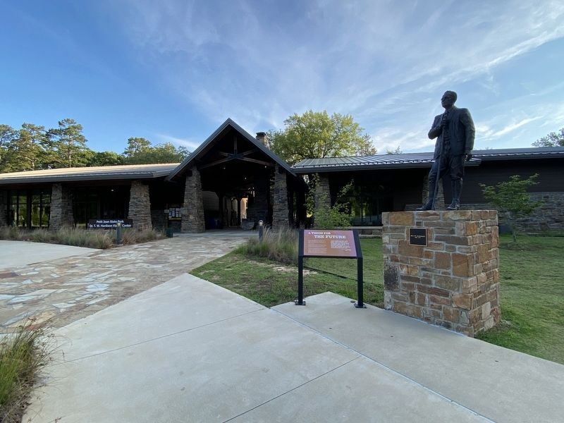
Dr. Thomas William Hardison was a resident of Petit Jean
Mountain for nearly half a century: Struck by the beauty and
natural wonders of the land, he was among the first to
imagine creating a park here to preserve its pristine grandeur
for . . . — — Map (db m233669) HM
They married, raised families, shared hopes and sorrows, and now lie within the hallowed grounds of Bold Pilgrim Cemetery. These were the Bold Pilgrims of Conway County.
[Editor's note: For clarity, only first and last names listed. For . . . — — Map (db m282873) HM
Bold Pilgrim is the final resting place for many courageous African Americans who settled in the Hickory Hill community of Conway County, Arkansas after the Civil War. These early African American settlers were fleeing oppressive conditions in . . . — — Map (db m282877) HM
The seat of justice for Conway County was first established in 1825, at the old town of Cadron, which had been the first county seat of Pulaski County. The County of Conway was named for Congressmen Henry Warton Conway. — — Map (db m237025) HM
Freedom is Not Free
The General William Lewis Chapter DAR
honors
All Veterans of
the Korean War
1950 – 1953
Marker placed December 31, 2002 — — Map (db m237021) WM
In honor of the men and
women of Conway County
who served in the armed
forces and sacrificed
unselfishly for the
freedom of the United
States of America — — Map (db m237019) WM
Vietnam Era
August 5, 1964 May 7, 1975
This plaque is in remembrance and honor of the Vietnam War veterans from Conway County, Arkansas and commemorates the courageous service and dedication these veterans gave for their
country. Special . . . — — Map (db m237005) WM
Erected in 2007 by Chapter 13 Disabled American Veterans
In memory and honor of all who served in World War I.
Doughboys
World War I, The War to End All Wars
The yanks are coming, the yanks are coming
and we won't be back till it's . . . — — Map (db m237004) WM
Erected in 2003 by Chapter 13 Disabled American Veterans
In memory and honor of all who served in World War II
Disabled American Veterans Chapter 13 Officers
Commander Pat Calhoun • Adjutant Rafel Brents • Service Officer Herb . . . — — Map (db m237029) WM
During the Civil War, first Confederate units and later Union units occupied and fought at and near Lewisburg. Confederate units included the Co. A of the 17th Arkansas Infantry, which was enlisted at Lewisburg in Oct. 1861, and the 18th Arkansas . . . — — Map (db m237032) HM
While a Confederate unit, the Conway Mounted Rifles, formed at Lewisburg in May 1861, the town was a Union base for much of the war. A garrison was established Sept. 28, 1863, and Col. Abraham H. Ryan recruited the 3rd Arkansas Cavalry (U.S.) there. . . . — — Map (db m170456) HM
These stones memorialize Old Lewisburg .
First trading post of Conway County .
Established 1825 by Stephen D. Lewis .
Made county seat 1831 to 1850
again 1873 to 1884 .
Incorporated 1844 . — — Map (db m170957) HM
This cabin was built in 1845 by John Walker, the second white settler on Petit Jean Mt. In 1854 it became the home of Owen & Jane West, a young couple who reared a family of 9 children, 5 of whom were born in this cabin without medical aid. . . . — — Map (db m233677) HM
Lewisburg A trading post and steamboat landing was founded near here in 1825 by Major William Lewis, his son Stephen D. Lewis and Dr. Nimrod Manifee. The location gave them land and river access. A town grew up around the trading post and . . . — — Map (db m237068) HM
Conway County in the Civil War
Conway County men served in both the Union and Confederate armies in the Civil War. Co. I, 1st Arkansas Mounted Rifles, Co. B, Carroll’s Cavalry, Co. I, 36th Arkansas Infantry, and several companies of the 10th . . . — — Map (db m96451) HM
The Arkansas River below you has a long history and continues to flow through time.
Bernard de La Harpe, the first European known
to explore the Arkansas River, arrived here in
1722. His expedition was commissioned by France
to establish . . . — — Map (db m233664) HM
Stout's Point provides a dramatic overlook of the Arkansas River, the water route
of the Congressionally-designated Trail of Tears National Historic Trail.
What is the Trail of Tears?
After passage of the Indian Removal Act of 1830, . . . — — Map (db m233662) HM
During the "roaring twenties" and the following decade of the Great Depression, this location on Petit Jean Mountain,
known as Stout's Point, saw changes that would influence the history of Petit Jean State Park.
In 1920, the Morrilton Chamber . . . — — Map (db m233668) HM
William Cummings Stout
(1824-1886)
In 1849, William Cummings Stout
was the first Arkansan ordained as
a priest of the Episcopal Church.
In 1855, he and his wife purchased
5000 acres spanning both sides of
the Arkansas River beginning . . . — — Map (db m233667) HM
One of the most captivating legends in Arkansas folklore
is the romantic tale of the mountain's namesake.
According to local legend, during the 18th century, a French
nobleman named Chavet was granted an expedition to explore
uncharted . . . — — Map (db m233666) HM
You are standing in a place that inspired establishment of
Petit Jean State Park and the entire Arkansas State Parks system.
A Lasting Legacy
Dr. T. W. Hardison is considered the father of
Arkansas State Parks. A long time resident . . . — — Map (db m233680) HM
When the Civilian Conservation Corps worked at Petit Jean in the 1930s, Dionicio Rodríguez, a
Mexican-born artist, sculpted this small bridge above a goldfish pond in a flower garden. He also sculpted a flower basket that is in rubble on the . . . — — Map (db m233676) HM
This statue honors Civilian Conservation Corps
Company V-1781. these skilled veterans of World War
One built Arkansas's first state park. — — Map (db m233674) HM WM
Davies Bridge, a sturdy Rustic-style structure, stands today as an emblem of the park's Civilian
Conservation Corps (CCC) heritage and the Davies family's contributions to Arkansas State Parks.
In 1932, Samuel G. Davies, a graduate of . . . — — Map (db m233672) HM
Through time, Cedar Falls has cut through vast layers of
sandstone, creating Cedar Creek Canyon which reaches a
depth of 400 feet.
The rock layer capping Petit Jean Mountain is sandstone, an
ancient sedimentary formation deposited as sand in a . . . — — Map (db m233681) HM
The prehistoric rock art in Rock House Cave is part of our heritage that can never be replaced. Once it is gone, it is gone forever. It is up to us to preserve these images for as long as possible until the endless forces of wind and water turn . . . — — Map (db m233671) HM
As you explore these unique structures around Petit Jean State Park,
you will find that nature and history are strongly connected here.
Rock House Cave - Explore this sandstone
bluff shelter and look for ancient Native
American . . . — — Map (db m233679) HM
Company V-1781 was the
designation of Petit Jean's CCC.
camp. The "V" indicated the
company employed World War I
veterans. The situation was
relatively unique: only 10 percent
of CCC camps around the United
States were veteran camps. . . . — — Map (db m233675) HM
Formed over eons, this inspiring landscape offers us a sense of wonder.
The landscape of Petit Jean State Park reveals a
story of stone, weather, and time.
Much of Petit Jean's exceptional landscape results from
earthen rock . . . — — Map (db m233687) HM
Exploring the geologic story here connects you with Petit Jean Mountain
Lepidodendron
One of the dominant tree-like plants of
either the Carboniferous Period (359-299
million years ago) or the late
Pennsylvanian Period (323-299 . . . — — Map (db m233678) HM
Following the stock market
crash of 1929, the United States
plunged into the depths of the
Great Depression. By 1932, the
unemployment rate was a
staggering 23%. Over 13 million
Americans had lost their jobs.
In a landslide victory, . . . — — Map (db m233673) HM
In this small log building Albert Pike noted lawyer, poet and mason taught school in 1832. He later went to Little Rock to become editor of the Advocate. — — Map (db m96857) HM
Camp Jesse Turner, located on Pickett Hill on the east side
of Van Buren (Crawford County), was a small, specialized
railroad training camp for soldiers to learn to operate
railroads captured in enemy territory, worldwide, during
World War II. . . . — — Map (db m244063) HM
The companies of soldiers that came out
of Van Buren were formed at this historic
landmark. It is also the site where some
infantry and Calvary units camped and
drilled. There were nine different
companies that were formed in . . . — — Map (db m96864) HM
[Northwest face]
1899
Furled but not forgotten
1861 C.S.A. 1865
Erected by the Mary Lee Chapter
United Daughters of the Confederacy
[Southwest face]
Battles
Oak Hill – Aug. 10, 1861.
Elk Horn – March 6 to 8, 1862. . . . — — Map (db m236850) WM
Remember those who served
and those who died
Killed in Action
Maj. Walter Hugh Moon
Capt. Jimmy Cartwright
LCpl. Roger Dale Cecil
LCpl. Billy Dale Livingston
SSgt. Samuel Ray Nixon
PFC. Jewel Lee Rainwater
GMG1 Arthur C. . . . — — Map (db m100703) WM
On this lawn
was erected our first
Courthouse in 1841 and
has been the scene for many
events during the wars
in which Crawford County boys fought.
Mexican War, 1846.
War Between the States, 1861-1865.
Spanish American War, 1898. . . . — — Map (db m96859) WM
Using advanced technology to understand the past.
Like the methods of Crime Scene Investigators, science provides a variety of ways to look beneath the surface of the Drennen House grounds for evidence of the past. Techniques like . . . — — Map (db m120491) HM
On December 27, 1862, Union columns totaling 8,000 troops and thirty pieces of artillery under the command of Generals James G. Blunt and F.J. Herron marched south from Cane Hill and Prairie Grove to conduct a raid on Rebel-held Van Buren. At . . . — — Map (db m250681) HM
The Battle of Prairie Grove was a grim moment for the Confederate Army. This conflict severed all chances for the South to use Northwest Arkansas as a route to invade Missouri. The shattered and defeated soldiers retreated from Prairie Grove to Van . . . — — Map (db m96617) HM WM
Erected in memory of
our Confederate soldiers
from Ark., Tex., La., Mo., and
Indian territory,
who lost their lives in the
Battles of Oak Hill, Elk Horn,
and Prairie Grove. — — Map (db m96632) WM
In memory of
Merle D. Hay
Thomas Enwright
James B. Gresham
They were the first members of
the Expeditionary Army of the
United States in France to die
that we might live
stricken on the field of glory,
November 3, . . . — — Map (db m96633) WM
Freedom of Speech • Freedom of Worship
Freedom from Want • Freedom from Fear
This park, "Freedom Park" embodies the spirit of "Four Freedoms" by Norman Rockwell. Elements of the park were designed to reflect each of the Freedoms. The . . . — — Map (db m244099) HM
GFWC Women's League of Van Buren
Proudly Dedicates this Clock as a Symbol of our Appreciation to all Veterans.
May it Stand to Honor all the Men and Women of the Military who have Bravely Served
and their Families who have Sacrificed so . . . — — Map (db m244105) WM
There is no doubt that other structures,
demolished at some point in the family's history,
stood on the Drennen-Scott property.
Like many wealthy 19th-century households, this one had privies, a well, smokehouse, carriage house, . . . — — Map (db m120515) HM
Hebe, Greek goddess of youth and happiness was placed in her fountain on the Crawford County Courthouse lawn in 1908 by the Women's Village Improvement Society.
Repairs were made to both Hebe and fountain in memory of Robert Benham who served . . . — — Map (db m97670) HM
The residents of Log Town were witness to the retreat of the Rebel army through Van Buren and onward through their settlement. High on Log Town Hill the community watched as masses of Southern soldiers crowded the hill trying desperately to reach . . . — — Map (db m96614) HM
From the front of his home, John Drennen could overlook the bustling port town of Van Buren, including the wharf originally known as Phillips Landing.
Until after the Civil War, the Arkansas River and the steamboats that plied its . . . — — Map (db m120427) HM
The Butterfield stage route
between Saint Louis and San
Francisco passed through the
main street of Van Buren,
Arkansas and crossed the
river at this point.
— — Map (db m96457) HM
Brig. General Francis J. Herron
Herron was Blunt's aggressive and bold subordinate, "they
cooperate well, and handle the rebels without gloves," declared
a Union officer. He led the Second and Third (Missouri) Divisions,
and was ready . . . — — Map (db m243979) HM
This active and restored railroad depot, completed
around 1902 by the Frisco Railroad Company, stands
as a living memorial to the entrepreneurial spirit and
the great periods of commerce that railroads brought
to our city.
As early as . . . — — Map (db m243970) HM
By a natural turn in the Arkansas River, Van Buren began at
the water's edge in 1818, straight down this hill. So, the first
muddy trail from the river came directly and in directly to this
spot - and became the hub of activity for Van Buren and . . . — — Map (db m243972) HM
The Blue Star Service Flag
The Blue Star Service Flag became a symbol of pride, honor and
service for families during World War I. Each blue star represented
a member of their family who was serving in the armed forces and
the . . . — — Map (db m244103) HM
Sunday, December 28, 1862
The day started like any other cold December Sunday, by nightfall, Van Buren's citizens would know everything had changed. The Civil War had come home.
As they came out of church and made their way toward home . . . — — Map (db m243975) HM
After the Dec. 7, 1862, Battle of Prairie Grove, the Union Frontier Division set out to strike Confederate forces on the Arkansas River. On Dec. 27, 8,000 Union troops headed south through the Boston Mountains. They hit Van Buren on Dec. 28 and . . . — — Map (db m119954) HM
The military history of the United States spans a period of more than two centuries. During these years, the United States evolved from a new nation fighting Great Britain for independence (1775-1783), through the monumental American Civil War . . . — — Map (db m244110) HM WM
John Drennen made profitable choices during his diverse professional life as merchant, bank trustee, plantation owner, and Indian agent.
He linked his future to the fledgling town of Van Buren, and built his family home here, . . . — — Map (db m120426) HM
On July 27, 1954, the Charleston School Board unanimously voted to integrate all grade levels of its public school system, becoming the first in the South to do so. The Board's decision was in response to the May 17, 1954 United States Supreme . . . — — Map (db m198421) HM
Ozark was designated as the county seat of Franklin County in 1837, and the first court house in the county was erected on this site in 1838. — — Map (db m120001) HM
Korea
1950 – 1953
Garlande Darter
Charles McCartney
Otis E. Hutchinson
Vietnam 1965-1975
Rickey Pyle
Otis E. Hutchinson, Jr.
John F. Schaffer
Wayne J. Sanders
Iraq
1990 – 1991
Charleston's . . . — — Map (db m120873) WM
On March 29, 1864, troops of the 30th Texas Cavalry and local partisans attacked the Union post at Roseville south of here, burning 133 bales of cotton and two cotton gins. They returned in force on May 4 and drove the defending troops of the 2nd . . . — — Map (db m119956) HM
[Stone monument]
Trail of Tears
1832-1840
Arkansas River valley
routes
Choctaw – Chickasaw
Muscogee Creek
Seminole – Cherokee
[Panel]
Trail of Tears Routes through Franklin County
1. Northern Route through . . . — — Map (db m236869) HM
The citizens of Franklin County have caused this monument to be erected ·· Not to glorify war but forever to serve the cause of peace ·•·
Here we enshrine forever the glorious memory of the living and the dead who through their valiant efforts . . . — — Map (db m120876) WM
This property
has been placed on the
National Register
of Historic Places
by the United States
Department of the Interior
B. D. Pennington House
circa 1888 — — Map (db m225357) HM
Clarksville in the Civil War
Clarksville was a key point in the defense of the Arkansas River Valley during the Civil War. Confederate troops occupied the town several times before Union forces took Little Rock and Ft. Smith, gaining . . . — — Map (db m96447) HM
Restorations by Dave & Geneva Devazier 1996
[Second plaque]
This property
has been placed on the
National Register
of Historic Places
by the United States
Department of the Interior
115 Grandview Avenue — — Map (db m282689) HM
The first anthracite coal was mined near here on the land of E.B. Alston by a Mr. Walker in 1840. Sample of coal were taken to Little Rock and examined by William E. Woodruff, who pronounced it superior to that found in Pennsylvania. Mr. Walker went . . . — — Map (db m96638) HM
This bell was in use at the school at Lone Pine 1921-1953. The bricks in this monument were made on the site and used to build the Hagarville Academy in 1918. — — Map (db m225423) HM
Erected 1901
and donated to
Logan Co.
at the cost of $5,600
$2,500 paid by
Choctaw Oklahoma and
Gulf Railroad Co.
Balance by citizens — — Map (db m309629) HM
Logan County
Vietnam Veterans
Lost In Service
Dickason, Clyde Leroy
Frost, James Allen
Harper, Larry Neil
Reinecius, Karl Lewis
Sanders, Wayne Jackson
Satterfield, John Stephen
Schluterman, David Frank
Vories, John Lloyd . . . — — Map (db m129529) WM
Eiffel Tower Park was established in 2014 on the West side of the
Paris town square. The Eiffel Tower was a gift to the city by a former
resident and pastor, Don Eubanks. A 7 foot water feature with fountain
was added to the 18 foot tower to . . . — — Map (db m129685) HM
In Honor of those Who Served and Died
WW I
Baldwin, Herbert ·
Cabe, Floyd ·
Carpenter, James ·
Cummens, Forrest ·
Miller, Walter ·
Moore, August ·
Richardson, James ·
Rogers, Lee, ·
Turner, Don ·
Weaver, Clayton
WW . . . — — Map (db m310063) WM
In late September 1863, Confederate Col. J.O. Shelby's cavalry headed north to raid into Missouri. On Sept. 27, 1863, Shelby's scouts found Co. H, 1st Arkansas Infantry (U.S.) camped at Haguewood Prairie near present-day Paris. The Union troops . . . — — Map (db m129518) HM
Scotia was selected as the county seat in 1830, the year after the county was created. When Johnson County was formed in 1833, the county seat in Pope was moved to Dwight Mission, whence it was moved the next year to Morristown, on the north side of . . . — — Map (db m170741) HM
This Bois D'Arc tree is also known as an Osage Orange, Hedge Apple, or Bow Wood tree. Historically, the wood was used by Native Americans to make strong and resilient bows and arrows. The early settlers also used it to make hubs, spokes, fence . . . — — Map (db m225453) HM
Kirkbride Potts built Potts Inn in the 1850s and it served as a Butterfield Stage Route stop. When war began in 1861, Potts joined the Pope County Home Guard. Four sons were in the Confederate army. Thomas, Joseph and Richard Potts enlisted in the . . . — — Map (db m119958) HM
Kirkbride Potts, with help from his wife Pamelia Logan Potts, designed and constructed this large and stately building between 1850 and 1858. He patterned it after the Classical Revival style he knew in his home state of Pennsylvania; however, he . . . — — Map (db m120871) HM
Potts Inn John Kirkbride Potts (1803-1879) was born in Pennsylvania and moved to Arkansas in the 1820s. In 1828 he settled by Galla Creek, eventually acquiring 650 acres of land. Potts went to California in the Gold Rush of 1849: he failed to . . . — — Map (db m225451) HM
Historic stage coach tavern erected by Kirkbride Potts with slave labor. This tavern was a station on the Butterfield-Overland Mail. It was operated as a tavern both before and after the existence of the Butterfield-Overland Mail contract. It has . . . — — Map (db m225477) HM
'The Arkansea' was a land of mystery, wonder and riches...
Back east rumors grew of the Arkansea, a land of vast swamps, gators, buffalo, elk, beaver, and more bear than could be imagined. There were huge flocks of green and yellow . . . — — Map (db m142029) HM
Late in the afternoon of January 17*, 1906, [see note below] a fire started in the Chronister Brothers grocery. Three hours later, twenty-two buildings, valued at two-hundred-fifty thousand dollars, were in ashes. Half of the central business . . . — — Map (db m225443) HM
[First plaque]
This property
has been placed on the
National Register
of Historic Places
by the United States
Department of the Interior
[Second plaque]
In 1885 Rev. G.W. Harkey the first minister of this church had . . . — — Map (db m225446) HM
This property
J. Madison White
has been placed on the
National Register of
Historic Places
by the United States
Department of the Interior — — Map (db m225429) HM
In 1854, Mr. J. L. Shinn established a business at this location in what was then called a cactus prairie. By 1870, other businesses had been established and residence had been built so the community was incorporated and was named Russellville, . . . — — Map (db m225435) HM
This stone is a marker from the old Military Road which extended from Little Rock to Ft. Smith. The marker was found west of Dardanelle in 1940 by Mr. Henry Sellers, District Highway Engineer, while supervising the construction of Arkansas Highway . . . — — Map (db m142032) HM
Pope County in the Civil War
Pope County soldiers served in at least 10 companies that were raised for Confederate service during the Civil War, fighting in battles east of the Mississippi River and in Arkansas. Two companies were . . . — — Map (db m119957) HM
The first steamboat to ascend the Arkansas River, the Comet, arrived at Arkansas Post on March 31, 1820, and river travel was transformed.
Two years later people in the new town of Little Rock were jubilant over the arrival of the first . . . — — Map (db m142031) HM
210 entries matched your criteria. The first 100 are listed above. Next 100 ⊳